


Seneca Falls, New York
Seneca Falls is a community of 6,956 people in Seneca County, New York, founded in April 22, 1831.
Why visit Seneca Falls
Townapedia lists 22 museums and landmarks, 10 parks and trails, 9 places to eat, 3 places to stay and 1 attraction in and around town.
Highlights include Elizabeth Cady Stanton House, Amelia Bloomer House, Suffrage Park and Women's Rights National Historical Park.
July is the warmest month, with average highs of 79°F; January lows average 16°F, and about 57 inches of snow fall in a normal year.
Weather in Seneca Falls
Forecast from the National Weather Service. Full forecast
About Seneca Falls
Seneca Falls is a hamlet and census-designated place in Seneca County, New York, United States. The population was 6,681 at the 2010 census. The 2020 census population of Seneca Falls CDP was 6,809. The hamlet is in the Town of Seneca Falls, east of Geneva.
From the Wikipedia article Seneca Falls (CDP), New York (this version), under CC BY-SA 4.0.
Things to do1

Museums and landmarks22

Elizabeth Cady Stanton House
Monument and historic site · National Register of Historic Places · 0.4 mi
Seneca Falls, New York
32 Washington Street, Seneca Falls

Amelia Bloomer House
Monument and historic site · National Register of Historic Places
Historic home in Seneca Falls, New York

Fourth Ward School
Monument and historic site · National Register of Historic Places · 0.4 mi
School building in Seneca Falls, New York
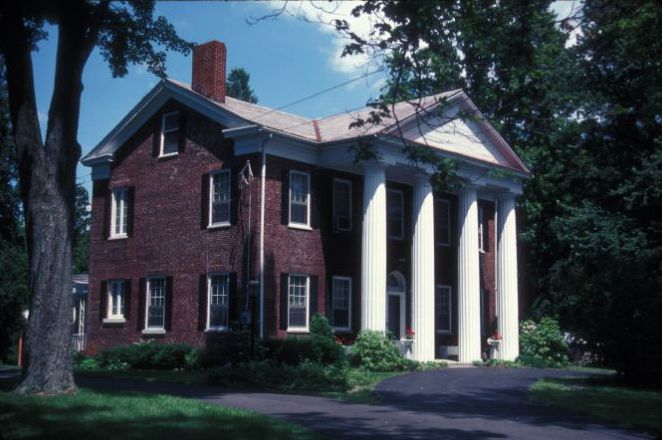
Hunt House
Monument and historic site · National Register of Historic Places · 2.4 mi
Historic house in Waterloo, New York, United States

Hutchinson Homestead
Monument and historic site · National Register of Historic Places · 3.6 mi
Cayuga, New York, NRHP-listed, in Cayuga County

James Russell Webster House
Monument and historic site · National Register of Historic Places · 3.2 mi
Historic house in New York, United States

Julius and Harriet Bull House
Monument and historic site · National Register of Historic Places · 2.4 mi
Historic house in New York, United States

M'Clintock House
Monument and historic site · National Register of Historic Places · 3.3 mi
Historic house in New York, United States

United States Post Office
Monument and historic site · National Register of Historic Places · 3.4 mi
Government building in Waterloo, New York

United States Post Office
Monument and historic site · National Register of Historic Places
Government building in Seneca Falls, New York

Waterloo Library
Monument and historic site · National Register of Historic Places · 3.3 mi
Library in Waterloo, New York


William H. Burton House
Monument and historic site · National Register of Historic Places · 3.3 mi
Historic house in New York, United States
10 more on the map.
Parks, trails and playgrounds10


Restaurants and cafes9

Lin's Kitchen
Restaurant · Chinese
71 Fall Street, Seneca Falls
Tu-Su 11:00-21:00


Where to stay3
Microtel Inn & Suites by Wyndham Seneca Falls
Motel and hotel · 2.0 mi
1966 Route 5 and 20, Seneca Falls
Churches and places of worship9
First Presbyterian Church
Church · National Register of Historic Places · 3.3 mi
Saint Paul's Church
Church · National Register of Historic Places · 3.2 mi
United Methodist Church
Church · National Register of Historic Places · 3.3 mi
Shopping3
Schools, colleges and libraries13
Healthcare2
Map of Seneca Falls
72 places. The map loads OpenStreetMap tiles when you open it.
Climate by month
Monthly table
| Month | High | Low | Rain | Snow |
|---|---|---|---|---|
| Jan | 30°F | 16°F | 1.8 in | 13.5 in |
| Feb | 32°F | 17°F | 1.6 in | 13.3 in |
| Mar | 40°F | 24°F | 2.4 in | 12.8 in |
| Apr | 54°F | 35°F | 2.8 in | 1.8 in |
| May | 67°F | 46°F | 3.3 in | 0.0 in |
| Jun | 75°F | 56°F | 3.6 in | 0.0 in |
| Jul | 79°F | 61°F | 3.7 in | 0.0 in |
| Aug | 78°F | 59°F | 3.5 in | 0.0 in |
| Sep | 71°F | 52°F | 3.3 in | 0.0 in |
| Oct | 58°F | 41°F | 3.8 in | 0.1 in |
| Nov | 46°F | 32°F | 2.5 in | 4.7 in |
| Dec | 36°F | 23°F | 2.3 in | 10.4 in |
U.S. Climate Normals 1991-2020 for Geneva Rsch Farm Hcn (12 mi away), NOAA NCEI.
People and cost of living
American Community Survey 5-year estimates, 2020-2024, U.S. Census Bureau. Estimates have margins of error, larger for small towns.
Disaster history
Seneca County has had 10 federal disaster declarations since 2000, most often for biologicals.
- 2020-03-20: Covid-19 Pandemic (Biological)
- 2020-03-13: Covid-19 (Biological)
- 2018-10-01: Severe Storms And Flooding (Flood)
- 2012-10-28: Hurricane Sandy (Hurricane)
- 2005-09-30: Hurricane Katrina Evacuation (Hurricane)
- 2004-08-03: Severe Storms And Flooding (Severe Storm)
OpenFEMA disaster declarations summaries.
Getting there and nearby towns
Ithaca Tompkins International Airport (ITH) is the nearest airport with scheduled flights listed in OpenStreetMap, 34 miles away.
- Union Springs 7 mi southeast, about 12 min by car
- Geneva 10 mi west, about 16 min by car
- Auburn 12 mi east, about 19 min by car
- Clyde 12 mi north, about 20 min by car
- Phelps 14 mi west, about 22 min by car
- Lyons 14 mi northwest, about 23 min by car
- Melrose Park 14 mi east, about 23 min by car
- Weedsport 15 mi northeast, about 24 min by car
- Clifton Springs 17 mi west, about 28 min by car
- Newark 18 mi northwest, about 28 min by car
Drive times are estimates from straight-line distance, not routes.
Local news
Headlines from INDB, the NEMICO news database.
Reviews, tips and questions
Loading what members have shared...
Sources and licences
- NCES EDGE (Public domain): public schools
- NOAA NCEI U.S. Climate Normals 1991-2020 (Public domain): climate by month
- OpenFEMA (Public domain): disaster declarations
- OpenStreetMap contributors (ODbL 1.0): places, airports, map data
- U.S. Census Bureau (Public domain): population, income, housing, education, commute
- Wikidata (CC0 1.0): elevation, founding date, time zone, website, landmarks and historic places
- Wikimedia Commons (see each image): photos
- Wikipedia (CC BY-SA 4.0): overview and history text
Photo credits
- SF Seneca Can., RochesterNY, Public domain
- U.S. Post Office, Seneca Falls, New York - 20220525, Andre Carrotflower, CC BY-SA 4.0
- US Post Office, Seneca Falls NY corner view 2013, Kenneth C. Zirkel, CC BY-SA 3.0
- US Post Office-Seneca Falls NY Aug 09, Doug Kerr from now in Binghamton, NY, CC BY-SA 2.0
- US Post Office, Seneca Falls NY, Kenneth C. Zirkel, CC BY-SA 3.0
- First Presbyterian Church, Seneca Falls, New York - 20220416, Andre Carrotflower, CC BY-SA 4.0
- Display board about Seneca Falls heritage sites (53857684209), Chris Rycroft from Madison, Wisconsin, United States, CC BY 2.0
- Trinity Church Seneca Falls NY Aug 09, Doug Kerr from now in Binghamton, NY, CC BY-SA 2.0
- Fall Street, Seneca Falls, New York - 20220416, Andre Carrotflower, CC BY-SA 4.0
- Albert Cook Memorial, Seneca Falls, New York - 20220525, Andre Carrotflower, CC BY-SA 4.0
- Wesleyan Methodist Church Seneca Falls NY, Kenneth C. Zirkel, CC BY-SA 3.0
- Wesleyan Methodist Church (Seneca Falls, New York) front view, Kenneth C. Zirkel, CC BY-SA 3.0
- ECStanton house2, J. Carl Burke, Jr., Public domain
- Amelia Bloomer House Seneca Falls NY, Kenneth C. Zirkel, CC BY-SA 3.0
- St Pauls Church Waterloo Aug 09, Doug Kerr from now in Binghamton, NY, CC BY-SA 2.0
- James Russell Webster House ca. 1877, James Russel Webster, Public domain
- First Presbyterian Church Waterloo Aug 09, Doug Kerr from now in Binghamton, NY, CC BY-SA 2.0
- HUNT HOUSE, JERRYE & ROY KLOTZ MD, CC BY-SA 3.0
- SenecaFallsNY JuliusAndHarrietBullHouse, Magicpiano, CC BY-SA 4.0
- United States Post Office Waterloo, New York entrance 2013, Kenneth C. Zirkel, CC BY-SA 3.0
- WesleyanChapel, National Park Service, Public domain
- Waterloo Library Aug 09, Doug Kerr from now in Binghamton, NY, CC BY-SA 2.0
- William H. Burton House Waterloo NY, Kenneth C. Zirkel, CC BY-SA 3.0
- Fourth Ward School Seneca Falls NY corner view, Kenneth C. Zirkel, CC BY-SA 3.0
- Hutchinson Homestead in Cayuga, New York 11 57 52 439000, Doncram, CC BY-SA 4.0
- JANE HUNT HOUSE, JERRYE & ROY KLOTZ MD, CC BY-SA 3.0
- Mynderse Library, SlipperyDude, CC BY-SA 3.0
- Union Street Band -WomensMarch -WomensMarch2018 -SenecaFalls -NY (38908888355), Marc Nozell from Merrimack, New Hampshire, USA, CC BY 2.0
- Love is Love -WomensMarch -WomensMarch2018 -SenecaFalls -NY (39097890474), Marc Nozell from Merrimack, New Hampshire, USA, CC BY 2.0
- Bridge from "It's a Wonderful Life" (53856421032), Chris Rycroft from Madison, Wisconsin, United States, CC BY 2.0
- Seneca Knitting Mills (53857734515), Chris Rycroft from Madison, Wisconsin, United States, CC BY 2.0
- Lima Presbyterian Church OH, Chris Rycroft, CC BY 2.0
- Entrance to Downtown Deli (53857313606), Chris Rycroft from Madison, Wisconsin, United States, CC BY 2.0
- Looking west along Fall Street (53857763620), Chris Rycroft from Madison, Wisconsin, United States, CC BY 2.0
- Brick buildings at the intersection of State Street, Fall Street, and Water Street (53857564243), Chris Rycroft from Madison, Wisconsin, United States, CC BY 2.0
- Bridge from "It's a Wonderful Life" (53857313941), Chris Rycroft from Madison, Wisconsin, United States, CC BY 2.0
- American Hotel of Lima New York, December 2023, Chris Rycroft from Madison, Wisconsin, United States, CC BY 2.0
- Lin's Kitchen Chinese restaurant (53857734075), Chris Rycroft from Madison, Wisconsin, United States, CC BY 2.0
- Shops and restaurants on Fall Street (53857313561), Chris Rycroft from Madison, Wisconsin, United States, CC BY 2.0
- Bridge from "It's a Wonderful Life" (53857683909), Chris Rycroft from Madison, Wisconsin, United States, CC BY 2.0


Page built October 30, 2026. Spotted a mistake? Tell us or suggest a place.