


Simpsonville, South Carolina
Simpsonville is a city of 26,144 people in Greenville County, South Carolina.
Why visit Simpsonville
Townapedia lists 11 museums and landmarks, 14 parks and trails, 129 places to eat, 8 places to stay and 2 attractions in and around town.
Highlights include Regal Simpsonville Stadium & IMAX, CCNB Amphitheatre, First Baptist Simpsonville and Burdette Building.
July is the warmest month, with average highs of 90°F; January lows average 30°F.
Weather in Simpsonville
Forecast from the National Weather Service. Full forecast
About Simpsonville
Simpsonville is a city in Greenville County, South Carolina, United States. It is part of the Greenville, SC Metropolitan Statistical Area. The population is 23,354, according to the 2020 census, up from 18,238 in the 2010 census. The city's 2024 Annual Financial Audit estimates the population to be about 27,500.
From the Wikipedia article Simpsonville, South Carolina (this version), under CC BY-SA 4.0.
Things to do2

Museums and landmarks11
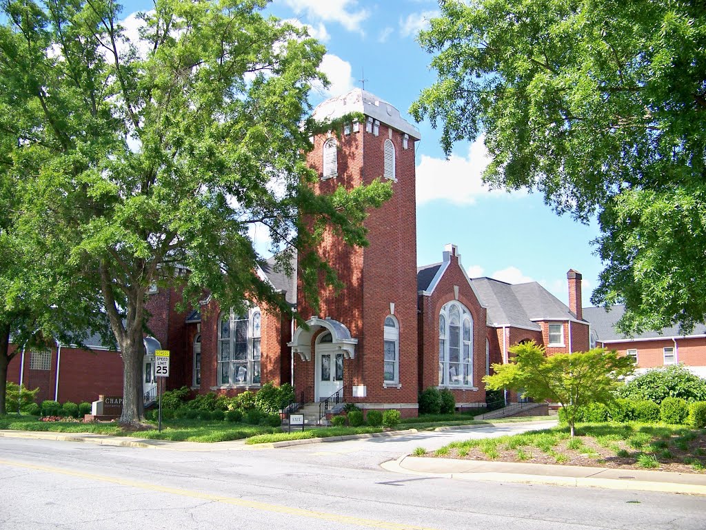
First Baptist Simpsonville
Monument and historic site · Baptist · National Register of Historic Places · 0.8 mi
Church building in Simpsonville, South Carolina, U.S.A.

Burdette Building
Monument and historic site · National Register of Historic Places · 0.6 mi
Building in Simpsonville, South Carolina, U.S.A.

Cannon Building
Monument and historic site · National Register of Historic Places · 4.0 mi
Building in South Carolina, United States

F. W. Welborn House
Monument and historic site · National Register of Historic Places · 3.7 mi
House in Fountain Inn, United States of America

Fountain Inn High School
Monument and historic site · National Register of Historic Places · 3.7 mi
High school in Fountain Inn, South Carolina, United States

Fountain Inn Principal's House and Teacherage
Monument and historic site · National Register of Historic Places · 4.3 mi
Historic house in South Carolina, United States

James A. Fulmer House
Monument and historic site · National Register of Historic Places · 3.8 mi
Historic house in Fountain Inn, South Carolina

McDowell House
Monument and historic site · National Register of Historic Places · 3.6 mi
House in Fountain Inn, South Carolina


Robert Quillen Office and Library
Monument and historic site · National Register of Historic Places · 4.0 mi
Library in Fountain Inn, South Carolina


Parks, trails and playgrounds14



2 more on the map.
Restaurants and cafes129




117 more on the map.
History
Simpsonville was incorporated on August 13, 1901. The city is named after Peter Simpson, a farmer from Laurens County who provided blacksmithing services and became the local postmaster.
The Burdette Building, Cureton-Huff House, Hopkins Farm, and Simpsonville Baptist Church are listed on the National Register of Historic Places.
The oldest brick building in the city is a former pharmacy built in 1886 at 101 East Curtis Street.
Established in 1901, The Woodside Mill, a textile mill, became Simpsonville's largest employer. The Woodside Mill includes an antique water tower.
The Simpsonville Clock Tower was built in 1987 and is the city's main landmark.
In October 2018, a winning lottery ticket for a $1.6 billion Mega Millions jackpot was sold at the #7 KC Mart in Simpsonville.
From the History section of Simpsonville, South Carolina on Wikipedia, under CC BY-SA 4.0.
Where to stay8
Holiday Inn Express & Suites Greenville SE - Simpsonville
Motel and hotel · 1.1 mi
642 Fairview Road, Simpsonville
Churches and places of worship30
The Methodist Church of Simpsonville
Church · Methodist · 0.4 mi
215 Southeast Main Street, Simpsonville
East Georgia Road Independent Baptist Church
Church · Baptist · 1.1 mi
724 East Curtis Street, Simpsonville
Shopping25
Gas and EV charging16
Schools, colleges and libraries30
Brashier Middle College Charter High
School · 3.2 mi
1830 West Georgia Road Building 203, Simpsonville
Golden Strip Career And Technology Center
School · 5.8 mi
1120 East Butler Road, Greenville
Healthcare21
Map of Simpsonville
250 places. The map loads OpenStreetMap tiles when you open it.
Climate by month
Monthly table
| Month | High | Low | Rain |
|---|---|---|---|
| Jan | 53°F | 30°F | 4.3 in |
| Feb | 57°F | 33°F | 4.0 in |
| Mar | 65°F | 38°F | 4.5 in |
| Apr | 73°F | 47°F | 4.2 in |
| May | 80°F | 56°F | 3.7 in |
| Jun | 87°F | 64°F | 4.5 in |
| Jul | 90°F | 68°F | 4.4 in |
| Aug | 88°F | 67°F | 4.9 in |
| Sep | 83°F | 61°F | 3.7 in |
| Oct | 74°F | 49°F | 3.6 in |
| Nov | 64°F | 38°F | 3.9 in |
| Dec | 56°F | 32°F | 4.7 in |
U.S. Climate Normals 1991-2020 for Fountain Inn 2 Sw (4 mi away), NOAA NCEI.
People and cost of living
American Community Survey 5-year estimates, 2020-2024, U.S. Census Bureau. Estimates have margins of error, larger for small towns.
Disaster history
Greenville County has had 25 federal disaster declarations since 2000, most often for hurricanes.
- 2026-04-07: Severe Winter Storm (Winter Storm)
- 2026-01-23: Severe Winter Storm (Winter Storm)
- 2025-03-23: Table Rock Fire Complex (Fire)
- 2024-09-29: Hurricane Helene (Hurricane)
- 2024-09-26: Hurricane Helene (Tropical Storm)
- 2024-08-05: Hurricane Debby (Tropical Storm)
OpenFEMA disaster declarations summaries.
Getting there and nearby towns
Donaldson Field Airport at SCTAC (GDC) is the nearest airport with scheduled flights listed in OpenStreetMap, 7 miles away.
- Fountain Inn 4 mi southeast, about 6 min by car
- Mauldin 5 mi northwest, about 7 min by car
- Five Forks 6 mi north, about 10 min by car
- Gantt 9 mi northwest, about 15 min by car
- Greenville 10 mi northwest, about 15 min by car
- Greer 14 mi north, about 23 min by car
- Parker 14 mi northwest, about 22 min by car
- Powdersville 14 mi west, about 23 min by car
- Berea 16 mi northwest, about 25 min by car
- Easley 20 mi west, about 32 min by car
Drive times are estimates from straight-line distance, not routes.
Local news
Headlines from INDB, the NEMICO news database.
Reviews, tips and questions
Loading what members have shared...
Sources and licences
- NCES EDGE (Public domain): public schools
- NOAA NCEI U.S. Climate Normals 1991-2020 (Public domain): climate by month
- OpenFEMA (Public domain): disaster declarations
- OpenStreetMap contributors (ODbL 1.0): places, airports, map data
- U.S. Census Bureau (Public domain): population, income, housing, education, commute
- Wikidata (CC0 1.0): elevation, founding date, time zone, website, landmarks and historic places
- Wikimedia Commons (see each image): photos
- Wikipedia (CC BY-SA 4.0): overview and history text
Photo credits
- Big Logs Plaza in Simpsonville, SC (30749090490), Mike Kalasnik from Charlotte, USA, CC BY-SA 2.0
- Simpsonville Plaza Shopping Center (30973837702), Mike Kalasnik from Charlotte, USA, CC BY-SA 2.0
- Simpsonville Downtown Clocktower, Jerry Stevens, CC BY-SA 3.0
- Simpsonville Baptist Church, Bill Fitzpatrick, CC BY-SA 3.0
- Dual Flock Camera, S. Pliney Circle, Simpsonville, SC, FROLENIUS, CC0
- Simpsonville Library - panoramio, Tony Crescibene, CC BY-SA 3.0
- Simpsonville Baptist Church - Simpsonville, SC, Upstateherd, CC BY-SA 4.0
- F.W Welborn House, Bill Fitzpatrick, CC BY-SA 3.0
- McDowell House Historic, Bill Fitzpatrick, CC BY-SA 3.0
- Burdette Building, Simpsonville, SC, Upstateherd, CC BY-SA 4.0
- Cannon Building, Bill Fitzpatrick, CC BY-SA 3.0
- James A. Fulmer House, Upstateherd, CC BY-SA 4.0
- Fountain Inn High School, Bill Fitzpatrick, CC BY-SA 3.0
- Robert Quillen Office and Library, Bill Fitzpatrick, CC BY-SA 3.0
- Fountain Inn Principal's House and Teacherage, Bill Fitzpatrick, CC BY-SA 3.0
- Lawrence L. Richardson House, Upstateherd, CC BY-SA 4.0
- Space Shuttle (pinball), Darth-Wiki-Man, CC BY-SA 4.0
- Tron Arcade Game, Darth-Wiki-Man, CC BY-SA 4.0
- Tron Arcade Machine, Darth-Wiki-Man, CC BY-SA 4.0
- 101 E Curtis Street, Bill Fitzpatrick, CC BY-SA 3.0
- Solar eclipse partial 2017-08-21 fl=1600mm f8 iso200 1-320th.sec ND5 filter, Rkinch, CC BY-SA 4.0
- Solar eclipse of 2017-08-21 totality medium exposure, Rkinch, CC BY-SA 4.0
- Solar eclipse of 2017-08-21 totality short exposure, Rkinch, CC BY-SA 4.0
- Heritage Park Railroad Station - panoramio, Tony Crescibene, CC BY-SA 3.0
- Heritage Park Railroad - panoramio, Tony Crescibene, CC BY-SA 3.0
- Heritage Park Office - panoramio, Tony Crescibene, CC BY-SA 3.0
- Heritage Park - panoramio (1), Tony Crescibene, CC BY-SA 3.0
- Baseball Sunset - panoramio, Tony Crescibene, CC BY-SA 3.0
- Baseball - panoramio, Tony Crescibene, CC BY-SA 3.0
- Baseball Field - panoramio (1), Tony Crescibene, CC BY-SA 3.0
- Sparkles - panoramio, Tony Crescibene, CC BY-SA 3.0
- Birthday Bash 2012 - panoramio, Tony Crescibene, CC BY-SA 3.0
- Phidippus clarus 8700, platycryptus, CC BY 2.0
- Phidippus clarus 8682, platycryptus, CC BY 2.0
- Phidippus clarus 8612, platycryptus, CC BY 2.0
- Gazebo in Winter - panoramio, Dan Cleveland, CC BY-SA 3.0
- Phidippus clarus 8630, platycryptus, CC BY 2.0
- Phidippus clarus 8662, platycryptus, CC BY 2.0
- Phidippus clarus 8706, platycryptus, CC BY 2.0


Page built October 30, 2026. Spotted a mistake? Tell us or suggest a place.