
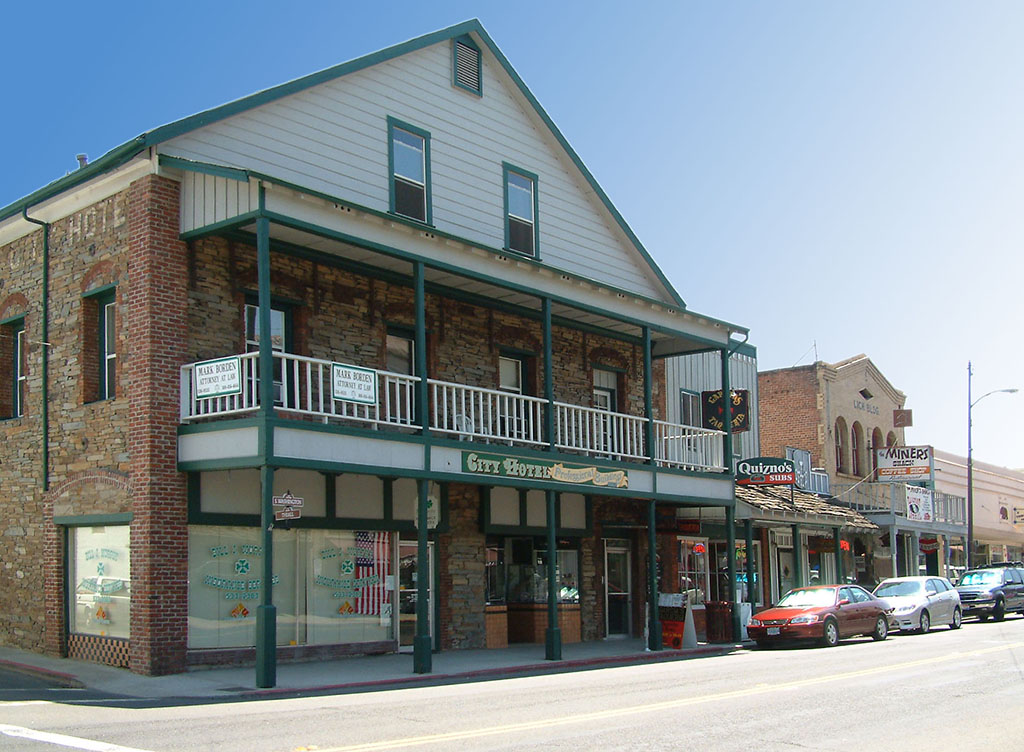

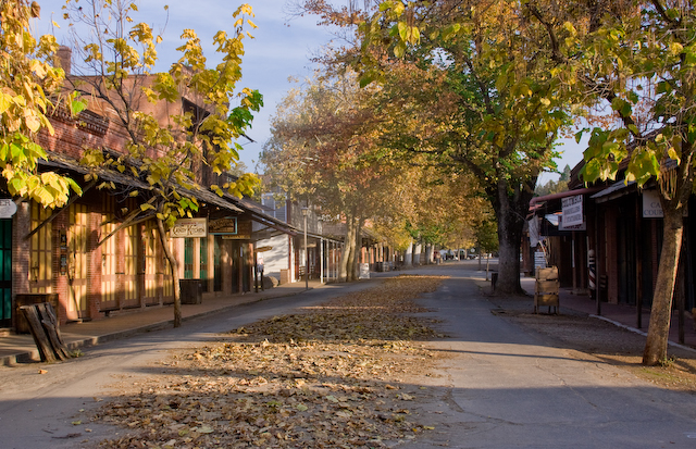


Sonora, California
Sonora is a city of 4,919 people in Tuolumne County, California, founded in 1850.
Why visit Sonora
Townapedia lists 14 museums and landmarks, 8 parks and trails, 48 places to eat, 7 places to stay and 1 attraction in and around town.
Highlights include Regal Sonora Stadium 10, City Hotel, Columbia State Historic Park and Coffils Park.
July is the warmest month, with average highs of 93°F; December lows average 32°F.
Weather in Sonora
Forecast from the National Weather Service. Full forecast
About Sonora
Sonora is the only incorporated city in Tuolumne County, California, United States, of which it is also the county seat. Founded during the California Gold Rush by Mexican miners from Sonora (after which the city is named), the city population was 5,003 during the 2020 census, an increase from the 4,610 counted during the 2010 census.
From the Wikipedia article Sonora, California (this version), under CC BY-SA 4.0.
Things to do1

Museums and landmarks14

City Hotel
Monument and historic site · National Register of Historic Places
Listed on the National Register of Historic Places (NRHP) in Tuolumne County
Columbia State Historic Park
Monument and historic site · National Register of Historic Places · 3.6 mi
California State Historic Park

Emporium
Monument and historic site · National Register of Historic Places · 3.0 mi
Historic building in Jamestown, California, United States

Sugg House
Monument and historic site · National Register of Historic Places
Historic house in Sonora, California, United States


Track Bus No. 19
Monument and historic site · National Register of Historic Places · 2.9 mi
Place in California listed on National Register of Historic Places

Veterans Memorial Military Museum
Museum
9 North Washington Street, Sonora
Mo-Fr 10:00-14:00; Sa 11:00-15:00
2 more on the map.
Parks, trails and playgrounds8


Restaurants and cafes48


Goodness Cafe
Cafe · Coffee Shop, Sandwich, Argentinian · 0.5 mi
230 North Washington Street, Sonora
Mo-Sa 07:30-14:30


Cocina Michocana
Restaurant · Mexican · 0.8 mi
770 Mono Way, Sonora
Mo-Su 11:00-21:00
Escondite De La Torre
Restaurant · Mexican
100 South Washington Street, Sonora
Th-Tu 07:00-14:00,19:00-02:00
Schnoog's Cafe & Espresso
Cafe · Coffee Shop, Sandwich, Dessert · 1.0 mi
36 more on the map.
History
Sonora was founded by Mexican miners during the California gold rush. Sonorans were alongside Chileans among the most experienced miners in the rush. Named after their home state of Sonora, Mexico, it was once a booming center of industry and trade in California's Mother Lode. Most of the gold removable with traditional mining techniques was quickly extracted, leaving miners to use more complex and expensive mining techniques to reach deep pockets of quartz and gold. Sonora as well as other mining towns of the era experienced economic hardship when the value of gold decreased. As "gold fever" died down, Sonora's size and population steadily decreased over the years. In c. 1851, the Sonora Hebrew Cemetery was formed by the Hebrew Benevolent Society and predominantly contains the graves of European-born Jews who emigrated to Gold Country.
The Tuolumne County Museum and History Center preserves the town's Gold Rush legacy.
From the History section of Sonora, California on Wikipedia, under CC BY-SA 4.0.
Where to stay7
Churches and places of worship4
Shopping16
Gas and EV charging4
Schools, colleges and libraries19
Healthcare3
Map of Sonora
124 places. The map loads OpenStreetMap tiles when you open it.
Climate by month
Monthly table
| Month | High | Low | Rain | Snow |
|---|---|---|---|---|
| Jan | 56°F | 33°F | 6.3 in | 0.0 in |
| Feb | 58°F | 34°F | 5.5 in | 0.0 in |
| Mar | 62°F | 37°F | 5.4 in | 0.0 in |
| Apr | 67°F | 40°F | 3.0 in | 0.0 in |
| May | 76°F | 46°F | 1.5 in | 0.0 in |
| Jun | 85°F | 51°F | 0.3 in | 0.0 in |
| Jul | 93°F | 57°F | 0.0 in | 0.0 in |
| Aug | 92°F | 56°F | 0.1 in | 0.0 in |
| Sep | 87°F | 51°F | 0.2 in | 0.0 in |
| Oct | 76°F | 43°F | 1.6 in | 0.0 in |
| Nov | 63°F | 36°F | 3.2 in | 0.0 in |
| Dec | 55°F | 32°F | 5.5 in | 0.0 in |
U.S. Climate Normals 1991-2020 for Sonora (1 mi away), NOAA NCEI.
People and cost of living
American Community Survey 5-year estimates, 2020-2024, U.S. Census Bureau. Estimates have margins of error, larger for small towns.
Disaster history
Tuolumne County has had 15 federal disaster declarations since 2000, most often for fires.
- 2026-07-26: Dove Fire (Fire)
- 2023-04-03: Severe Winter Storms, Straight-Line Winds, Flooding, Landslides, And Mudslides (Severe Storm)
- 2023-03-10: Severe Winter Storms, Flooding, Landslides, And Mudslides (Flood)
- 2023-01-14: Severe Winter Storms, Flooding, Landslides, And Mudslides (Flood)
- 2020-08-22: Wildfires (Fire)
- 2020-03-22: Covid-19 Pandemic (Biological)
OpenFEMA disaster declarations summaries.
Getting there and nearby towns
Columbia Airport (COA) is the nearest airport with scheduled flights listed in OpenStreetMap, 4 miles away.
- Jamestown 2 mi southwest, about 4 min by car
- East Sonora 2 mi east, about 4 min by car
- Columbia 4 mi northwest, about 6 min by car
- Phoenix Lake 5 mi northeast, about 7 min by car
- Mono Vista 7 mi east, about 10 min by car
- Soulsbyville 7 mi east, about 12 min by car
- Tuolumne City 8 mi east, about 12 min by car
- Cedar Ridge 8 mi northeast, about 13 min by car
- Twain Harte 9 mi northeast, about 14 min by car
- Angels 11 mi northwest, about 18 min by car
Drive times are estimates from straight-line distance, not routes.
Local news
Headlines from INDB, the NEMICO news database.
Reviews, tips and questions
Loading what members have shared...
Sources and licences
- NCES EDGE (Public domain): public schools
- NOAA NCEI U.S. Climate Normals 1991-2020 (Public domain): climate by month
- OpenFEMA (Public domain): disaster declarations
- OpenStreetMap contributors (ODbL 1.0): places, airports, map data
- U.S. Census Bureau (Public domain): population, income, housing, education, commute
- Wikidata (CC0 1.0): elevation, founding date, time zone, website, landmarks and historic places
- Wikimedia Commons (see each image): photos
- Wikipedia (CC BY-SA 4.0): overview and history text
Photo credits
- Sonora CA, G.Rogers ( Rodge500 ), CC BY-SA 2.5
- Sugg House, Karl98007, CC BY-SA 3.0
- ColumbiaCAMainSt, Chris Krylov, CC BY 3.0
- Hetch Hetchy Track Bus No. 19, John Crane, CC BY-SA 4.0
- 2009-0724-CA-Jamestown-Emporium, Bobak Ha'Eri, CC BY 3.0
Page built October 30, 2026. Spotted a mistake? Tell us or suggest a place.