


South Berwick, Maine
South Berwick is a community of 3,381 people in York County, Maine.
Why visit South Berwick
Townapedia lists 13 museums and landmarks, 10 parks and trails, 2 places to eat and 4 attractions in and around town.
Highlights include Powderhouse Hill, Cummings Hill, Hamilton House and Berwick Academy.
July is the warmest month, with average highs of 82°F; January lows average 15°F.
Weather in South Berwick
Forecast from the National Weather Service. Full forecast
About South Berwick
South Berwick is a census-designated place (CDP) and the primary village in the town of South Berwick, York County, Maine, United States. It is in southwestern York County, in the northwestern corner of the town of South Berwick. It is bordered to the north by the town of Berwick, and to the southwest, across the Salmon Falls River, by the town of Rollinsford, New Hampshire.
From the Wikipedia article South Berwick (CDP), Maine (this version), under CC BY-SA 4.0.
Things to do4


Museums and landmarks13

Hamilton House
Monument and historic site · National Register of Historic Places · 1.5 mi
Historic house in South Berwick, Maine, United States

Berwick Academy
Monument and historic site · National Register of Historic Places
College preparatory school in South Berwick, Maine, United States
Rollinsford Town Hall
Monument and historic site · National Register of Historic Places · 1.2 mi
Town hall in Rollinsford, New Hampshire, United States
667 Main Street, Rollinsford

Sarah Orne Jewett House
Museum · National Register of Historic Places · 0.4 mi
Building in Maine, United States
5 Portland Street, South Berwick

Conway Junction Railroad Turntable Site
Monument and historic site · National Register of Historic Places · 1.5 mi
Historic site in Maine, USA

Jewett-Eastman House
Monument and historic site · National Register of Historic Places · 0.7 mi
House in South Berwick, Maine
Rollinsford Grade School
Monument and historic site · National Register of Historic Places · 1.3 mi

Salmon Falls Mill Historic District
Monument and historic site · National Register of Historic Places · 1.1 mi
Historic district in New Hampshire, United States
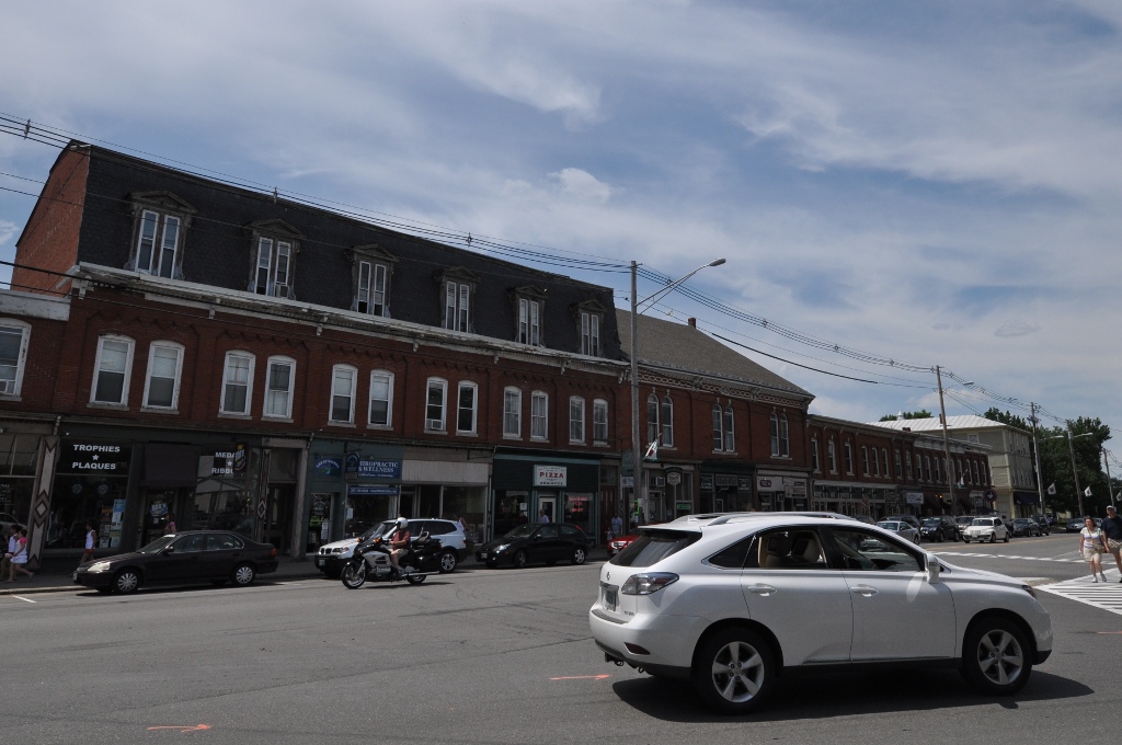
South Berwick Village Historic District
Monument and historic site · National Register of Historic Places · 0.6 mi
Historic district in South Berwick, Maine, United States
Cummings Shoe Factory
Monument and historic site · National Register of Historic Places · 1.3 mi

Portsmouth Company Cotton Mills: Counting House
Monument and historic site · National Register of Historic Places · 0.7 mi
1 more on the map.
Parks, trails and playgrounds10






Restaurants and cafes2


Churches and places of worship2
Gas and EV charging1
Schools, colleges and libraries21
Frances G. Hopkins Elementary School At Horne Street
School · 4.4 mi
78 Horne St., Dover
Map of South Berwick
53 places. The map loads OpenStreetMap tiles when you open it.
Climate by month
Monthly table
| Month | High | Low | Rain |
|---|---|---|---|
| Jan | 33°F | 15°F | 2.5 in |
| Feb | 35°F | 17°F | 2.2 in |
| Mar | 44°F | 25°F | 3.7 in |
| Apr | 57°F | 35°F | 3.7 in |
| May | 67°F | 45°F | 3.5 in |
| Jun | 77°F | 54°F | 3.9 in |
| Jul | 82°F | 60°F | 3.5 in |
| Aug | 81°F | 58°F | 3.2 in |
| Sep | 73°F | 50°F | 3.4 in |
| Oct | 60°F | 39°F | 4.4 in |
| Nov | 48°F | 31°F | 3.9 in |
| Dec | 37°F | 22°F | 3.3 in |
U.S. Climate Normals 1991-2020 for Rochester Skyhaven Ap (7 mi away), NOAA NCEI.
People and cost of living
American Community Survey 5-year estimates, 2020-2024, U.S. Census Bureau. Estimates have margins of error, larger for small towns.
Disaster history
York County has had 26 federal disaster declarations since 2000, most often for severe storms.
- 2024-05-24: Severe Winter Storm (Winter Storm)
- 2024-03-20: Severe Storms And Flooding (Severe Storm)
- 2023-09-14: Hurricane Lee (Hurricane)
- 2023-03-22: Severe Storm And Flooding (Severe Storm)
- 2022-03-15: Severe Storm And Flooding (Coastal Storm)
- 2020-04-04: Covid-19 Pandemic (Biological)
OpenFEMA disaster declarations summaries.
Getting there and nearby towns
Portsmouth International Airport (PSM) is the nearest airport with scheduled flights listed in OpenStreetMap, 11 miles away.
- Berwick 4 mi northwest, about 7 min by car
- Somersworth 5 mi west, about 8 min by car
- Dover 5 mi southwest, about 8 min by car
- North Berwick 6 mi northeast, about 9 min by car
- South Eliot 7 mi south, about 11 min by car
- Durham 9 mi southwest, about 14 min by car
- Rochester 10 mi northwest, about 16 min by car
- Kittery 10 mi south, about 16 min by car
- Cape Neddick 10 mi southeast, about 16 min by car
- Portsmouth 12 mi south, about 19 min by car
Drive times are estimates from straight-line distance, not routes.
Local news
Headlines from INDB, the NEMICO news database.
Reviews, tips and questions
Loading what members have shared...
Sources and licences
- NCES EDGE (Public domain): public schools
- NOAA NCEI U.S. Climate Normals 1991-2020 (Public domain): climate by month
- OpenFEMA (Public domain): disaster declarations
- OpenStreetMap contributors (ODbL 1.0): places, airports, map data
- U.S. Census Bureau (Public domain): population, income, housing, education, commute
- Wikidata (CC0 1.0): elevation, founding date, time zone, website, landmarks and historic places
- Wikimedia Commons (see each image): photos
- Wikipedia (CC BY-SA 4.0): overview and history text
Photo credits
- Main Street, South Berwick ME, John Phelan, CC BY-SA 4.0
- Jackson Library (shadow), Berwick Academy, South Berwick, Maine, Wikiuser100, CC BY-SA 4.0
- Fogg Memorial Building closeup, Berwick Academy, South Berwick, Maine, Wikiuser100, CC BY-SA 4.0
- Porte-cochere at Burleigh-Davidson Building, Berwick Academy, South Berwick, Maine, Wikiuser100, CC BY-SA 4.0
- Fogg Memorial Building, Berwick Academy, South Berwick, Maine, Wikiuser100, CC BY-SA 4.0
- Fogg Memorial Building landscape, Berwick Academy, South Berwick, Maine, Wikiuser100, CC BY-SA 4.0
- Berwick Academy commons, South Berwick, Maine, Wikiuser100, CC BY-SA 4.0
- 1791 Building, Berwick Academy, South Berwick, Maine, Wikiuser100, CC BY-SA 4.0
- Jeppesen Science Center, Berwick Academy, South Berwick, Maine, Wikiuser100, CC BY-SA 4.0
- Jackson Library (sun), Berwick Academy, South Berwick, Maine, Wikiuser100, CC BY-SA 4.0
- South Berwick, Maine, Quintin Soloviev, CC BY 4.0
- Hamilton House in South Berwick, InAweofGod'sCreation, CC BY 2.0
- SouthBerwickME HamiltonHouse, User:Magicpiano, CC BY-SA 4.0
- Salmon Falls Mills, Rollinsford, New Hampshire, Doug Kerr from Albany, NY, United States, CC BY-SA 2.0
- SouthBerwickME JewettEastmanHouse, User:Magicpiano, CC BY-SA 4.0
- SouthBerwickME VillageCenter, User:Magicpiano, CC BY-SA 4.0
- SouthBerwickME ConwayJunctionTurntableFoundation, User:Magicpiano, CC BY-SA 4.0
- SouthBerwickME PortsmouthCompanyCottonMills CountingHouse, User:Magicpiano, CC BY-SA 4.0
- Guard stone at Berwick Academy, Wikiuser100, CC BY-SA 4.0
- SouthBerwickME JewettHouse LeftView, Magicpiano, CC BY-SA 3.0
- SouthBerwickME JewettHouse RightView, Magicpiano, CC BY-SA 3.0
- SouthBerwickME JewettHouse Rear, Magicpiano, CC BY-SA 3.0
- SouthBerwickME JewettHouse Garden, Magicpiano, CC BY-SA 3.0
- SouthBerwickME JewettHouse CarriageHouse, Magicpiano, CC BY-SA 3.0
- Salmon Falls River, Fredlyfish4, CC BY-SA 4.0
- Salmon Falls River dam, Fredlyfish4, CC BY-SA 4.0
- Rollinsford, New Hampshire (cropped), Quintin Soloviev, CC BY 4.0
- Rollinsford, New Hampshire, Quintin Soloviev, CC BY 4.0
- Town Hall, Rollinsford, New Hampshire, Doug Kerr from Albany, NY, United States, CC BY-SA 2.0
- RollinsfordNH GradeSchool, Magicpiano, CC BY-SA 3.0
- ME 236 sb past ME 91, April 2025, Mr. Matté (if there is an issue with this image, contact me using this image's Commons talk page , my Commons user talk page , or my English Wikipedia user talk page ; I'll know about it a lot faster), CC BY-SA 4.0
- Obo II Grave site, RiverBissonnette, CC BY-SA 4.0
- Vaughan Woods State Park 1, InAweofGod'sCreation, CC BY 2.0
- Vaughan Woods State Park 3, InAweofGod'sCreation, CC BY 2.0
- Vaughan Woods Memorial State Park, InAweofGod'sCreation, CC BY 2.0
- Platform on the Trail Vaughan Woods State Park, InAweofGod'sCreation, CC BY 2.0
- Vaughan Woods State Park 2, InAweofGod'sCreation, CC BY 2.0


Page built October 30, 2026. Spotted a mistake? Tell us or suggest a place.