


Sparkill, New York
Sparkill is a community of 1,483 people in Rockland County, New York.
Why visit Sparkill
Townapedia lists 55 museums and landmarks, 10 parks and trails, 25 places to eat, 2 places to stay and 5 attractions in and around town.
Highlights include Mercy University, St. Thomas Aquinas College, Christ Church and DeWint House.
July is the warmest month, with average highs of 86°F; January lows average 23°F, and about 33 inches of snow fall in a normal year.
Weather in Sparkill
Forecast from the National Weather Service. Full forecast
About Sparkill
Sparkill (English pronunciation: /ˈspɑːɹkɪl/ ), formerly known as Tappan Sloat, is a suburban hamlet and census-designated place in Orangetown, New York, United States located north of Palisades; east of Tappan; south of Piermont and west of the Hudson River. As of the 2020 census, Sparkill had a population of 1,581. The hamlet is home to St. Thomas Aquinas College and the Dominican Sisters of Sparkill.
From the Wikipedia article Sparkill, New York (this version), under CC BY-SA 4.0.
Things to do5

St. Thomas Aquinas College
School · 0.9 mi
Liberal arts college in New York

Museums and landmarks55

Christ Church
Monument and historic site · National Register of Historic Places · 0.4 mi
Listed on the NRHP in Sparkill, New York, United States
14 Union Street, Sparkill

DeWint House
Monument and historic site · National Register of Historic Places · 0.9 mi
Historic house in New York, United States

Abner Concklin House
Monument and historic site · National Register of Historic Places · 1.6 mi
Historic house in Palisades, New York

Abraham A. Haring House
Monument and historic site · National Register of Historic Places · 2.2 mi
House in Rockleigh, New Jersey
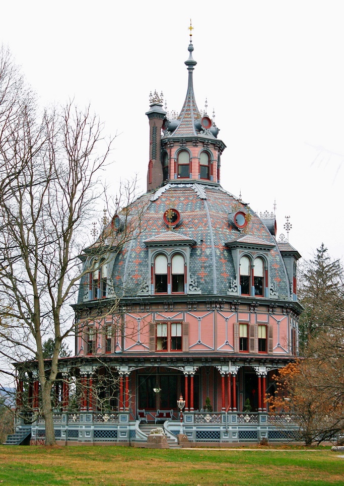
Armour-Stiner House
Monument and historic site · National Register of Historic Places · 3.3 mi
Historic house in Irvington, New York, United States

Big House
Monument and historic site · National Register of Historic Places · 1.5 mi
Historic house in New York, United States

Blauvelt House
Monument and historic site · National Register of Historic Places · 2.9 mi
Historic house in Harrington Park, New Jersey

Blauvelt House
Monument and historic site · National Register of Historic Places · 3.1 mi
Historic house in Norwood, New Jersey

Capt. Thomas Blanch House
Monument and historic site · National Register of Historic Places · 2.9 mi
Historic house in New Jersey, United States


Church of St. Joseph of Arimathea
Monument and historic site · National Register of Historic Places · 3.3 mi
Church building in Irvington, Greenburgh, Westchester County, New York, United States of America
Church of the Holy Communion
Monument and historic site · National Register of Historic Places · 2.7 mi
Church building in New Jersey, United States of America
Cliffside
Monument and historic site · National Register of Historic Places · 2.1 mi
Listed on the National Register of Historic Places
43 more on the map.
Parks, trails and playgrounds10

Tappan Golf Center
Golf course · 0.7 mi
Tappan Golf Center is 26 acres of family fun activities in Tappan, NY. Our miniature golf course features eighteen holes along a...
116 New York 303, Tappan
Mo-Su 07:00-22:00

Tallman Mountain State Park
Hiking and trails · 1.2 mi

Restaurants and cafes25

Bunbury's Coffee Shop
Cafe · Coffee Shop · 1.2 mi
460 Piermont Avenue, Piermont
Mo 08:00-14:00, Tu 07:00-14:00, We-Fr 07:00-16:00, Sa-Su 07:00-17:00

TWK Market Kitchen & Bar
Restaurant · Pizza, Coffee Shop, Burger, Seafood, Fish And Chips · 1.2 mi
485 Piermont Avenue, Piermont
We-Sa 10:00-19:00, Su 10:00-18:00
Sidewalk Bistro
Restaurant · French · 1.2 mi
Mo 12:00-22:00, We-Th 12:00-22:00, Fr-Sa 12:00-23:00, Su 12:00-21:00


Tequila Sal Y Limon
Restaurant · 1.2 mi
468 Piermont Ave., Piermont
13 more on the map.
Where to stay2
Churches and places of worship12
Our Lady of the Sacred Heart Catholic Church
Church · Roman Catholic · 0.7 mi
126 Kings Highway, Tappan
Saint Charles African Methodist Episcopal Zion Church
Church · African Methodist Episcopal Zion · 0.4 mi
432 Valentine Avenue, Sparkill
Shopping8
Gas and EV charging3
Schools, colleges and libraries46
Bergen County Institute For Science And Technology
School · 5.0 mi
162 Knickerbocker Road, Demarest
Map of Sparkill
166 places. The map loads OpenStreetMap tiles when you open it.
Climate by month
Monthly table
| Month | High | Low | Rain | Snow |
|---|---|---|---|---|
| Jan | 40°F | 23°F | 3.9 in | 9.4 in |
| Feb | 43°F | 24°F | 3.3 in | 10.9 in |
| Mar | 51°F | 31°F | 4.4 in | 5.8 in |
| Apr | 63°F | 40°F | 4.3 in | 0.7 in |
| May | 73°F | 50°F | 4.3 in | 0.0 in |
| Jun | 81°F | 59°F | 4.6 in | 0.0 in |
| Jul | 86°F | 64°F | 4.5 in | 0.0 in |
| Aug | 84°F | 63°F | 4.4 in | 0.0 in |
| Sep | 77°F | 56°F | 4.6 in | 0.0 in |
| Oct | 65°F | 45°F | 4.4 in | 0.0 in |
| Nov | 54°F | 36°F | 3.9 in | 0.3 in |
| Dec | 44°F | 29°F | 4.7 in | 5.6 in |
U.S. Climate Normals 1991-2020 for Dobbs Ferry-Ardsley Hcn (5 mi away), NOAA NCEI.
People and cost of living
American Community Survey 5-year estimates, 2020-2024, U.S. Census Bureau. Estimates have margins of error, larger for small towns.
Disaster history
Rockland County has had 20 federal disaster declarations since 2000, most often for hurricanes.
- 2023-07-22: Severe Storms And Flooding (Severe Storm)
- 2021-09-05: Remnants Of Hurricane Ida (Hurricane)
- 2021-09-02: Remnants Of Hurricane Ida (Hurricane)
- 2021-08-22: Hurricane Henri (Hurricane)
- 2020-10-02: Tropical Storm Isaias (Hurricane)
- 2020-03-20: Covid-19 Pandemic (Biological)
OpenFEMA disaster declarations summaries.
Getting there and nearby towns
Westchester County Airport (HPN) is the nearest airport with scheduled flights listed in OpenStreetMap, 12 miles away.
- Northvale 1 mi southwest, about 2 min by car
- Old Tappan 3 mi west, about 4 min by car
- Norwood 3 mi south, about 5 min by car
- Dobbs Ferry 4 mi east, about 6 min by car
- Harrington Park 4 mi southwest, about 6 min by car
- Closter 4 mi south, about 7 min by car
- Tarrytown 4 mi northeast, about 7 min by car
- Pearl River 4 mi northwest, about 7 min by car
- Alpine 4 mi south, about 7 min by car
- Demarest 5 mi south, about 9 min by car
Drive times are estimates from straight-line distance, not routes.
Local news
Headlines from INDB, the NEMICO news database.
Reviews, tips and questions
Loading what members have shared...
Sources and licences
- NCES EDGE (Public domain): public schools
- NOAA NCEI U.S. Climate Normals 1991-2020 (Public domain): climate by month
- OpenFEMA (Public domain): disaster declarations
- OpenStreetMap contributors (ODbL 1.0): places, airports, map data
- U.S. Census Bureau (Public domain): population, income, housing, education, commute
- Wikidata (CC0 1.0): elevation, founding date, time zone, website, landmarks and historic places
- Wikimedia Commons (see each image): photos
- Wikipedia (CC BY-SA 4.0): overview and history text
Photo credits
- Sparkill depot square, Taurus876 at en.wikipedia, Public domain
- NY 340 eb in Sparkill (1), Feb. 2023, Mr. Matté (if there is an issue with this image, contact me using this image's Commons talk page , my Commons user talk page , or my English Wikipedia user talk page ; I'll know about it a lot faster), CC BY-SA 4.0
- NY 340 eb in Sparkill (2), Feb. 2023, Mr. Matté (if there is an issue with this image, contact me using this image's Commons talk page , my Commons user talk page , or my English Wikipedia user talk page ; I'll know about it a lot faster), CC BY-SA 4.0
- CHRIST CHURCH, SPARKILL, ROCKLAND COUNTY, NY, JERRYE & ROY KLOTZ, M.D., CC BY-SA 4.0
- 9W Sparkill jeh, Jim.henderson, Public domain
- DeWint House Tappan, Alexisrael, CC BY-SA 3.0
- ABNER CONCKLIN HOUSE, PALISADES, ROCKLAND COUNTY, NY, JERRYE & ROY KLOTZ, M.D., CC BY-SA 4.0
- Haring-Vervalen House, Norwood, NJ, Unknown author Unknown author, Public domain
- Blauvelt House, Harrington Park, NJ, JERRYE & ROY KLOTZ M.D., CC BY-SA 4.0
- Armour-Stiner House (1), csouza_79, CC BY 2.0
- Joseph Dubois House, Rockleigh, NJ, JERRYE & ROY KLOTZ M.D., CC BY-SA 4.0
- Dobbs Ferry, NY, post office, Daniel Case, CC BY-SA 3.0
- Church of St. Joseph of Arimathea, Oct 2012, DK Big Fish, CC0
- Piermont Drawbridge, Alexisrael, CC BY-SA 3.0
- HARING-DEWOLF HOUSE, OLD TAPPAN, BERGEN COUNTY, JERRYE & ROY KLOTZ M.D., CC BY-SA 4.0
- Michael Salyer Stone House, Orangetown, NY, Daniel Case, CC BY-SA 3.0
- ROCKLAND ROAD BRIDGE HISTORIC DISTRICT, PIERMONT, ROCKLAND COUNTY, NY, JERRYE AND ROY KLOTZ, M.D., CC BY-SA 4.0
- ABRAHAM A. HARING HOUSE, ROCKLEIGH, BERGEN COUNTY, NJ, JERRYE & ROY KLOTZ M.D., CC BY-SA 3.0
- NEIDERHURST, PALISADES, ROCKLAND COUNTY, NY, JERRYE & ROY KLOTZ, M.D., CC BY-SA 4.0
- TERHUNE HOUSE, PARAMUS, BERGEN COUNTY, JERRYE & ROY KLOTZ M.D., CC BY-SA 4.0
- FIRST REFORMED CHURCH, PIEDMONT, ROCKLAND COUNTY NY, JERRYE & ROY KLOTZ, M.D., CC BY-SA 4.0
- HARING-BLAUVELT HOUSE, NORTHVALE, BERGEN COUNTY, NJ, JERRYE & ROY KLOTZ M.D., CC BY-SA 4.0
- GrandViewOnHudsonNY FormerWaysideChapel, User:Magicpiano, CC BY-SA 4.0
- BIG HOUSE, PALISADES, ROCKLAND COUNTY, NY, JERRYE & ROY KLOTZ, M.D., CC BY-SA 4.0
- TEUNIS HARING HOUSE, OLD TAPPAN, BERGEN COUNTY, JERRYE AND ROY KLOTZ M.D., CC BY-SA 4.0
- JohnAndreMemorial 2007 02, Rolf Müller ( User:Rolfmueller ), CC BY-SA 3.0
- Lord and Burnham Building, Daniel Case, CC BY-SA 3.0
- LITTLE HOUSE, PALISADES, ROCKLAND COUNTY NY, JERRYE & ROY KLOTZ, M.D., CC BY-SA 4.0
- HARING-CORNING HOUSE, ROCKLEIGH, BERGEN COUNTY, NJ, JERRYE & ROY KLOTZ M.D., CC BY-SA 4.0
- Nuits, Ardsley-on-Hudson, NY, Daniel Case, CC BY-SA 3.0
- WASHINGTON SPRING ROAD-WOODS ROAD HISTORIC DISTRICT, ROCKLAND COUNTY, NY, JERRYE & ROY KLOTZ, M.D., CC BY-SA 4.0
- Concklin-Sneden House front view, Zeete, CC BY-SA 3.0
- Blauvelt House, Norwood, NJ, JERRYE & ROY KLOTZ M.D., CC BY-SA 4.0
- Trolley exploring - an electric railroad guide to historic and picturesque places about New York, New Jersey, and New England (1904) (14574250168), Internet Archive Book Images, No restrictions
- PalisadesNY HaringEberleHouse, Magicpiano, CC BY-SA 4.0
- CLOSTER ROAD-OAK TREE ROAD HISTORIC DISTRICT, PALISADES, ROCKLAND COUNTY, NY, JERRYE & ROY KLOTZ, M.D., CC BY-SA 4.0
- RockleighNJ NicholasHaringHouse, Magicpiano, CC BY-SA 4.0
- ThomasBlanchHouse, Unknown author Unknown author, Public domain
- 352 Piermont Avenue - Piermont NY, Adam Moss, CC BY-SA 2.0
- ONDERDONK HOUSE, PIERMONT, ROCKLAND COUNTY, NY, JERRYE & ROY KLOTZ, M.D., CC BY-SA 4.0


Page built October 30, 2026. Spotted a mistake? Tell us or suggest a place.