


Springfield, Massachusetts
Springfield is a city of 154,749 people in Hampden County, Massachusetts, founded in 1636.
Why visit Springfield
Townapedia lists 130 museums and landmarks, 146 parks and trails, 87 places to eat, 9 places to stay and 7 attractions in and around town.
Highlights include The Zoo in Forest Park & Education Center, Michele & Donald D'Amour Museum of Fine Arts, The Amazing World of Dr. Seuss Museum and Dr. Seuss National Memorial Sculpture Garden.
July is the warmest month, with average highs of 85°F; January lows average 16°F.
Weather in Springfield
Forecast from the National Weather Service. Full forecast
About Springfield
Springfield is the most populous city in Hampden County, Massachusetts, United States, and its county seat. Springfield sits on the eastern bank of the Connecticut River near its confluence with three rivers: the western Westfield River, the eastern Chicopee River, and the eastern Mill River. At the 2020 census, the city's population was 155,929, making it the third most populous city in Massachusetts and the fourth most populous city in New England, after Boston, Worcester, and Providence. The Springfield metropolitan area, one of two metropolitan areas in Massachusetts (the other being Greater Boston), had a population of 699,162 in 2020.
From the Wikipedia article Springfield, Massachusetts (this version), under CC BY-SA 4.0.
Things to do7

The Zoo in Forest Park & Education Center
Zoo and aquarium · 3.1 mi
293 Sumner Ave, Springfield
Mo-Su 10:00-16:00


Museums and landmarks130

Michele & Donald D'Amour Museum of Fine Arts
Museum · 2.5 mi
49 Chestnut Street, Springfield
Tu-Sa 10:00-17:00, Su 11:00-17:00
The Amazing World of Dr. Seuss Museum
Museum · 2.5 mi
21 Edwards Street, Springfield
Tu-Sa 10:00-17:00, Su 11:00-17:00

Apremont Triangle Historic District
Monument and historic site · National Register of Historic Places · 2.6 mi
Human settlement in Springfield, Massachusetts, United States of America

Edward Bellamy House
Monument and historic site · National Register of Historic Places · 3.6 mi
Historic house in Massachusetts, United States
91;93 Church Street
Naismith Memorial Basketball Hall of Fame
Museum · 2.8 mi
1000 Hall of Fame Avenue, Springfield
Mo-Su 10:00-16:00

Paramount Theater
Monument and historic site · National Register of Historic Places · 2.9 mi
Theater and movie theater in Springfield, Massachusetts
1700;1708 Main Street

Quadrangle-Mattoon Street Historic District
Monument and historic site · National Register of Historic Places · 2.5 mi
Historic district in Springfield, Massachusetts, United States of America

South Congregational Church
Monument and historic site · National Register of Historic Places · 2.4 mi
Church building in Massachusetts, United States of America

Springfield Safe Deposit and Trust Company
Monument and historic site · National Register of Historic Places · 2.6 mi
Building in Massachusetts, United States of America
127 State Street

Upper Worthington Historic District
Monument and historic site · National Register of Historic Places · 2.1 mi
Historic district in Massachusetts, United States
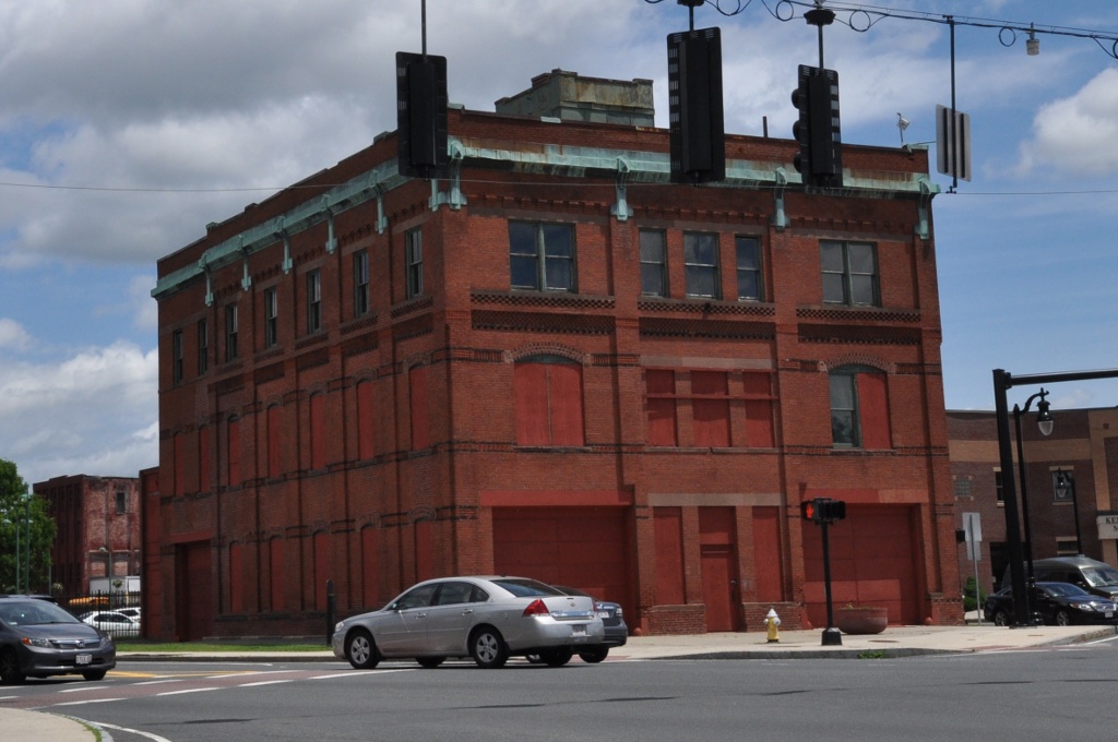


Winchester Square Historic District
Monument and historic site · National Register of Historic Places · 1.2 mi
Historic district in Massachusetts, United States
Academy Historic District
Monument and historic site · National Register of Historic Places · 5.6 mi
United States historic place
118 more on the map.
Parks, trails and playgrounds146


Springfield Armory National Historic Site
Park · 2.3 mi
1 Armory Square, Springfield
Mittineague Park
Park · 5.9 mi
Park in West Springfield, Massachusetts

134 more on the map.
Restaurants and cafes87

Chef Jiang
Restaurant · Chinese · 1.9 mi
Xiangyu Sichuan cuisine
800 Boston Road, Springfield
Su-Th 11:00-21:00; Fr-Sa 11:00-21:30
Hot Table
Restaurant · Sandwich · 2.8 mi
A sit-down/takeout restaurant located inside the Tower Square building. Serves sandwiches and sides with beverages
1500 Main Street
Mo-Sa 10:30-20:00

El Morro Bakery and Restaurant
Restaurant · Latin American · 2.0 mi
599 Page Boulevard, Springfield
Mo-Sa 07:00-18:00; Su 10:00-15:00
Ichiban East Longmeadow
Restaurant · Chinese, Japanese · 2.8 mi
422 North Main Street, East Longmeadow
Su 12:00+, Mo-Th 11:00-20:30, Fr-Sa 11:00-21:30
Jack Chen II Restaurant
Restaurant · Chinese · 1.7 mi
1193 Sumner Avenue, Springfield
Fr-Sa 11:00-23:00; Su 12:00-22:00; Mo 11:00-22:30; We,Th 11:00-22:30
Liberty's Mediterranean Giant Grinders
Restaurant · Mediterranean, Sandwich · 2.9 mi
63 Liberty Street, Springfield
Mo-Sa 11:00-20:00; Su off

Ninety-Nine Restaurant
Diner · American · 2.7 mi
390 North Main Street
Mo-Th 11:00-23:00, 09:00-18:00; Fr, Sa 11:00-00:00; Su 11:00-22:30
Pizza Works
Restaurant · Pizza, Sandwich · 2.2 mi
459 Dickinson Street, Springfield
Su-Th 10:00-00:00, Fr-Sa 10:00-02:00
Pizzaria Uno
Restaurant · Pizza, Burger, Chicken, Steak House, Salad, Pasta · 2.7 mi
820 Hall of Fame Avenue
Mo-Th,Su 11:00-23:30; Fr-Sa 11:00-00:30
Red Rose Pizzeria
Restaurant · Italian · 2.6 mi
1060 Main Street, Springfield
Th-Sa 10:00-19:00; Mo-We 10:00-18:00
75 more on the map.
Where to stay9
Churches and places of worship107
St Paul The Apostle Catholic Church
Church · Roman Catholic · 2.8 mi
225 Dwight Road
The Unitarian Universalist Society of Greater Springfield (UUSGS)
Place of worship · 3.2 mi
245 Porter Lake Drive, Springfield
Shopping24
Rocky's Ace Hardware
Hardware store · 3.7 mi
28 North Main Street, East Longmeadow
Gas and EV charging12
Schools, colleges and libraries142
Springfield Central High School
School · 1.1 mi
1840 Roosevelt Avenue, Springfield
Healthcare17
Map of Springfield
250 places. The map loads OpenStreetMap tiles when you open it.
Climate by month
Monthly table
| Month | High | Low | Rain |
|---|---|---|---|
| Jan | 35°F | 16°F | 2.8 in |
| Feb | 38°F | 17°F | 2.6 in |
| Mar | 47°F | 26°F | 3.4 in |
| Apr | 60°F | 35°F | 4.1 in |
| May | 72°F | 46°F | 3.7 in |
| Jun | 80°F | 55°F | 4.4 in |
| Jul | 85°F | 61°F | 4.2 in |
| Aug | 83°F | 59°F | 3.7 in |
| Sep | 75°F | 51°F | 4.6 in |
| Oct | 63°F | 39°F | 4.7 in |
| Nov | 51°F | 30°F | 3.5 in |
| Dec | 40°F | 22°F | 3.6 in |
U.S. Climate Normals 1991-2020 for Westfield Barnes Muni Ap (10 mi away), NOAA NCEI.
People and cost of living
American Community Survey 5-year estimates, 2020-2024, U.S. Census Bureau. Estimates have margins of error, larger for small towns.
Disaster history
Hampden County has had 19 federal disaster declarations since 2000, most often for severe storms.
- 2023-09-15: Hurricane Lee (Hurricane)
- 2020-03-27: Covid-19 Pandemic (Biological)
- 2020-03-13: Covid-19 (Biological)
- 2013-04-19: Severe Winter Storm, Snowstorm, And Flooding (Severe Storm)
- 2012-10-28: Hurricane Sandy (Hurricane)
- 2012-01-06: Severe Storm And Snowstorm (Severe Storm)
OpenFEMA disaster declarations summaries.
Getting there and nearby towns
Westover Air Reserve Base (CEF) is the nearest airport with scheduled flights listed in OpenStreetMap, 6 miles away.
- Windsor Locks 14 mi southwest, about 23 min by car
- Manchester 23 mi south, about 37 min by car
- Hartford 25 mi south, about 41 min by car
- East Hartford 25 mi south, about 40 min by car
- Storrs 26 mi southeast, about 42 min by car
- West Hartford 27 mi southwest, about 43 min by car
- Wethersfield 29 mi south, about 47 min by car
- Newington 31 mi south, about 50 min by car
- Willimantic 32 mi southeast, about 52 min by car
- New Britain 33 mi southwest, about 53 min by car
Drive times are estimates from straight-line distance, not routes.
Local news
Headlines from INDB, the NEMICO news database.
Reviews, tips and questions
Loading what members have shared...
Sources and licences
- NCES EDGE (Public domain): public schools
- NOAA NCEI U.S. Climate Normals 1991-2020 (Public domain): climate by month
- OpenFEMA (Public domain): disaster declarations
- OpenStreetMap contributors (ODbL 1.0): places, airports, map data
- U.S. Census Bureau (Public domain): population, income, housing, education, commute
- Wikidata (CC0 1.0): elevation, founding date, time zone, website, landmarks and historic places
- Wikimedia Commons (see each image): photos
- Wikipedia (CC BY-SA 4.0): overview and history text
Photo credits
- Springfield, MA, Quintin Soloviev, CC BY 4.0
- Springfield, MA Tornado 2011, June 1 cropped, User:Runningonbrains , original photo by Matt Putzel, CC BY-SA 3.0
- Springfield, MA Tornado 2011, June 1, Matt Putzel, CC BY-SA 3.0
- Race and ethnicity 2010- Springfield (5559842699), Eric Fischer, CC BY-SA 2.0
- Roger L Putnam Vocational Technical High School, Springfield MA, John Phelan, CC BY 4.0
- 161 Boston Road, Springfield MA, John Phelan, CC BY 4.0
- Homer Street School, Springfield MA, John Phelan, CC BY 4.0
- Watershops Pond, Springfield MA, John Phelan, CC BY-SA 4.0
- Welcome to Springfield College, Springfield MA, John Phelan, CC BY 4.0
- Blunt Park, Springfield MA, John Phelan, CC BY 4.0
- Stagg Field, Springfield College, Springfield MA, John Phelan, CC BY 4.0
- Stagg Field entrance, Springfield College, Springfield MA, John Phelan, CC BY 4.0
- Springfield Central High School, Springfield MA, John Phelan, CC BY 4.0
- Knox Automobile Co, Springfield MA, John Phelan, CC BY 4.0
- East Forest Park Branch Library, Springfield MA, John Phelan, CC BY-SA 4.0
- Winchester Square Park, Springfield MA, John Phelan, CC BY 4.0
- Mason Square Branch Library, Springfield MA, John Phelan, CC BY 4.0
- Springfield Municipal Operations Center, Springfield MA, John Phelan, CC BY 4.0
- SpringfieldMA FormerStJohnsChurch, Magicpiano, CC BY-SA 3.0
- SpringfieldMA StJohnsChurch EducationCenter, Magicpiano, CC BY-SA 3.0
- Frederick Harris Elementary School, Springfield MA, John Phelan, CC BY 4.0
- SpringfieldMA HancockApartments, Magicpiano, CC BY-SA 3.0
- Water Shops at Springfield Armory Today, Mbhankins, CC BY-SA 4.0
- Springfield Armory Watershops Pond 2013 12 25, Scott Kane, CC BY-SA 3.0
- Mill River, Springfield MA, John Phelan, CC BY 4.0
- SpringfieldMA StJamesApartments, Magicpiano, CC BY-SA 4.0
- SpringfieldMA WigglesworthBuilding, Magicpiano, CC BY-SA 4.0
- CRRC Springfield plant August 2026 4, 4300streetcar, CC BY 4.0
- CRRC Springfield plant August 2026 2, 4300streetcar, CC BY 4.0
- CRRC MBTA mockups at Springfield MA August 2026 3, 4300streetcar, CC BY 4.0
- SpringfieldMA IverniaApartments, Magicpiano, CC BY-SA 3.0
- CRRC MBTA mockups at Springfield MA August 2026 4, 4300streetcar, CC BY 4.0
- CRRC Springfield building August 2025, 4300streetcar, CC BY 4.0
- City View Commons, Springfield MA, John Phelan, CC BY-SA 3.0
- South Congregational Church, Springfield MA, John Phelan, CC BY-SA 3.0
- YMCA, Chestnut Street, Springfield MA, John Phelan, CC BY-SA 3.0
- Exterior - Museum of Fine Arts, Springfield, MA - DSC03877, Daderot, CC0
- Springfield Safe Deposit and Trust, Springfield MA, John Phelan, CC BY 3.0
- SpringfieldMA WinchesterSquareFireStation, User:Magicpiano, CC BY-SA 4.0
- Edward Bellamy House Chicopee Falls MA, National Park Service, Public domain


Page built October 30, 2026. Spotted a mistake? Tell us or suggest a place.