


Stillwater, Minnesota
Stillwater is a city of 19,355 people in Washington County, Minnesota.
Why visit Stillwater
Townapedia lists 38 museums and landmarks, 70 parks and trails, 80 places to eat, 8 places to stay and 7 attractions in and around town.
Highlights include Point Douglas-St. Louis River Road Bridge, Bridge No. 5721, Moritz Bergstein Shoddy Mill and Warehouse and Stillwater Overlook.
July is the warmest month, with average highs of 79°F; January lows average 5°F.
Weather in Stillwater
Forecast from the National Weather Service. Full forecast
About Stillwater
Stillwater is a city in the U.S. state of Minnesota and the county seat of Washington County. It is in the Minneapolis–Saint Paul metropolitan area, on the west bank of the St. Croix River, across from Houlton, Wisconsin. Stillwater's population was 19,394 at the 2020 census. Stillwater is often called "the birthplace of Minnesota" due to its role in the establishment of the state.
From the Wikipedia article Stillwater, Minnesota (this version), under CC BY-SA 4.0.
Things to do7

Point Douglas-St. Louis River Road Bridge
Bridge · National Register of Historic Places · 1.2 mi
Road bridge in Stillwater Township, Minnesota

Bridge No. 5721
Bridge · National Register of Historic Places · 3.6 mi
Bridge in United States of America

Stillwater Bridge
Bridge · National Register of Historic Places · 1.3 mi
Vertical-lift bridge connecting Stillwater, Minnesota and Houlton, Wisconsin over the St. Croix River

St. Croix Crossing
Bridge · 2.5 mi
Bridge between St. Joseph, Wisconsin, and Oak Park Heights, Minnesota (near Stillwater)

Manitou Fund Arts & Education Center
Cinema and theater · 1.2 mi
601 Main Street North, Stillwater

Museums and landmarks38

Moritz Bergstein Shoddy Mill and Warehouse
Monument and historic site · National Register of Historic Places · 1.5 mi
Building in Stillwater, Minnesota, United States
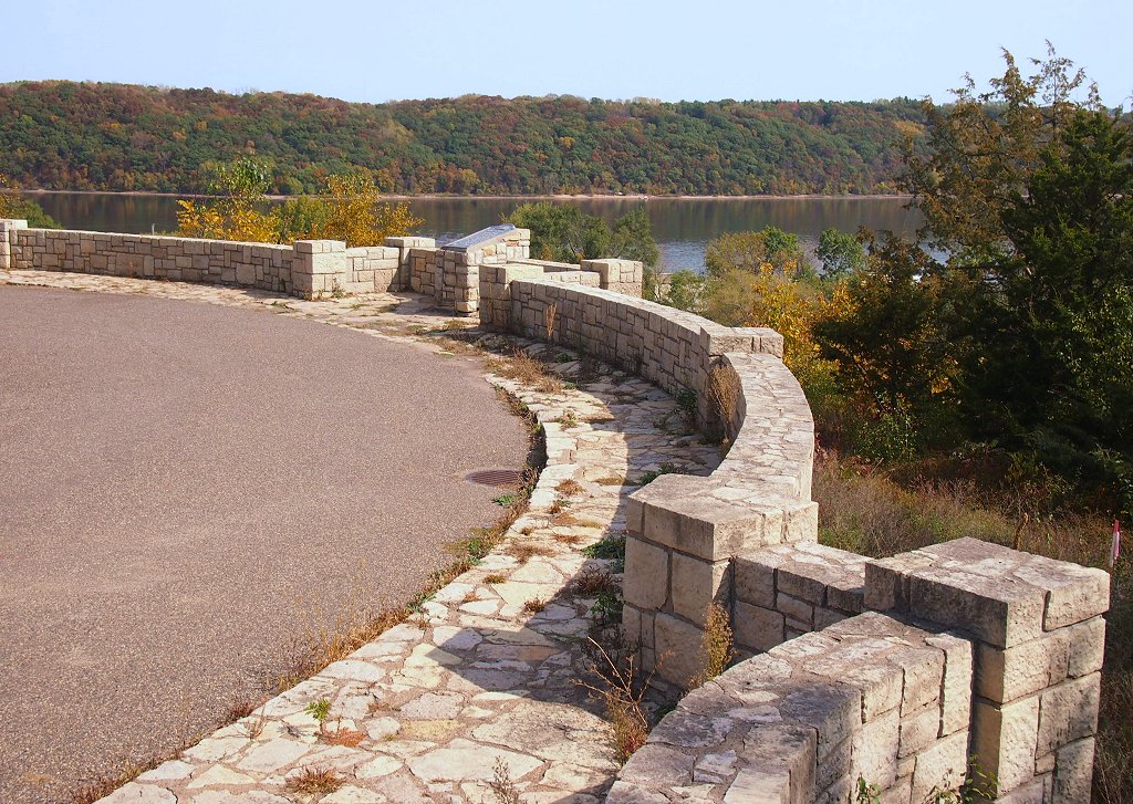
Stillwater Overlook
Monument and historic site · National Register of Historic Places · 2.1 mi
Scenic overlook in Minnesota, United States

Warden's House Museum
Monument and historic site · National Register of Historic Places · 1.1 mi
House in Stillwater, Minnesota

Albert Lammers House
Monument and historic site · National Register of Historic Places · 1.5 mi
House in Stillwater, Minnesota
Captain Austin Jenks House
Monument and historic site · National Register of Historic Places · 1.1 mi
Historic house in Minnesota, United States

Chicago, Milwaukee and St. Paul Freight House
Monument and historic site · National Register of Historic Places · 1.3 mi
Railway station in Stillwater, the United States of America

Henry Stussi House
Monument and historic site · National Register of Historic Places · 1.7 mi
Historic house in Minnesota, United States
Isaac Staples' Sawmill
Monument and historic site · National Register of Historic Places · 1.1 mi
Historic building in Stillwater, Minnesota, United States
Ivory McKusick House
Monument and historic site · National Register of Historic Places · 1.0 mi
Historic house in Minnesota, United States

Log Cabin
Monument and historic site · National Register of Historic Places · 2.1 mi
Historic restaurant in Oak Park Heights, Minnesota, United States


Minnesota Correctional Facility – Stillwater
Monument and historic site · National Register of Historic Places · 2.9 mi
Prison in Bayport, Minnesota, United States
Minnesota Territorial Prison
Monument and historic site · National Register of Historic Places · 1.2 mi
Former prison in Stillwater, Minnesota
26 more on the map.
Parks, trails and playgrounds70



Oak Park Crossing Park
Park · 2.3 mi
15125 60th Street North (South Frontage Road), Oak Park Heights
58 more on the map.
Restaurants and cafes80

Caribou Coffee
Cafe · Coffee Shop · 1.5 mi
2051 Washington Avenue, Stillwater
Sa-Su 06:00-18:00; Mo-Fr 05:30-19:00

Keys Cafe
Restaurant · 1.5 mi
1400 West Frontage Road, Stillwater
Mo 07:00-15:00; Tu-Sa 07:00-21:00; Su 08:00-15:00
The Next Stop Bar & Grill
Restaurant · 1.9 mi
1369 Main Street, Houlton
Mo 12:00-22:00; Tu 11:00-24:00; We-Fr 00:00-02:00, 11:00-24:00;...

Ziggy's
Bar and pub · 1.2 mi
132 Main Street South
Tu-Th 11:00-24:00; Fr-Sa 11:00-01:00; Su 11:00-21:00; Mo off
Mongolian Barbeque
Restaurant · 1.5 mi
1490 West Frontage Road, Stillwater
11:00-20:00
Acapulco Mexican Restaurant
Restaurant · Mexican · 1.5 mi
1240 West Frontage Road, Stillwater

68 more on the map.
History
In the 1830s, European Americans were pressing west into this territory. The U.S. government tried to arrange for their settlement in Native American lands, and on July 29 and September 29, 1837, it signed treaties with the local Ojibwe and Dakota nations to allow such settlement in the St. Croix Valley.
The settlement was founded on October 26, 1843, when four partners formed the Stillwater Lumber Company. Settlers were drawn by the area's abundant lumber and river traffic resulting from the industry. This was one of Minnesota's oldest towns, preceding Minneapolis by several years. Stillwater was officially incorporated as a city on March 4, 1854 (the same day as Saint Paul).
Stillwater is often called the "birthplace of Minnesota". In 1848, a territorial convention that began the process of establishing Minnesota as a state was held in Stillwater, at the corner of Myrtle and Main streets. Originally part of the Wisconsin Territory, Minnesota officially became a separate territory in 1849 and, after population increases, a state in 1858.
From the History section of Stillwater, Minnesota on Wikipedia, under CC BY-SA 4.0.
Where to stay8
Churches and places of worship10
St. Michael's Catholic Church
Church · Catholic · 1.3 mi
611 3rd Street South, Stillwater
Episcopal Church of the Ascension
Church · 1.0 mi
214 3rd Street North, Stillwater
Shopping23
Gas and EV charging8
Schools, colleges and libraries36
Healthcare6
Map of Stillwater
250 places. The map loads OpenStreetMap tiles when you open it.
Climate by month
Monthly table
| Month | High | Low | Rain |
|---|---|---|---|
| Jan | 22°F | 5°F | 0.8 in |
| Feb | 28°F | 8°F | 0.9 in |
| Mar | 41°F | 20°F | 1.6 in |
| Apr | 55°F | 34°F | 3.0 in |
| May | 67°F | 47°F | 4.2 in |
| Jun | 76°F | 58°F | 4.8 in |
| Jul | 79°F | 62°F | 4.4 in |
| Aug | 78°F | 60°F | 4.4 in |
| Sep | 71°F | 51°F | 3.3 in |
| Oct | 58°F | 38°F | 2.7 in |
| Nov | 41°F | 25°F | 1.8 in |
| Dec | 28°F | 12°F | 1.2 in |
U.S. Climate Normals 1991-2020 for Stillwater 2Sw (1 mi away), NOAA NCEI.
People and cost of living
American Community Survey 5-year estimates, 2020-2024, U.S. Census Bureau. Estimates have margins of error, larger for small towns.
Disaster history
Washington County has had 8 federal disaster declarations since 2000, most often for floods.
- 2020-04-07: Covid-19 Pandemic (Biological)
- 2020-03-13: Covid-19 (Biological)
- 2019-06-12: Severe Winter Storm, Straight-Line Winds, And Flooding (Flood)
- 2011-05-10: Severe Storms And Flooding (Flood)
- 2010-03-19: Flooding (Flood)
- 2005-09-13: Hurricane Katrina Evacuation (Hurricane)
OpenFEMA disaster declarations summaries.
Getting there and nearby towns
St. Paul Downtown Airport (STP) is the nearest airport with scheduled flights listed in OpenStreetMap, 14 miles away.
- Lake Elmo 6 mi southwest, about 10 min by car
- Oakdale 8 mi southwest, about 13 min by car
- North St. Paul 9 mi west, about 14 min by car
- Maplewood 10 mi west, about 16 min by car
- Hugo 10 mi northwest, about 16 min by car
- Vadnais Heights 12 mi west, about 19 min by car
- Little Canada 13 mi west, about 20 min by car
- St. Paul 15 mi southwest, about 25 min by car
- Lino Lakes 15 mi northwest, about 24 min by car
- Forest Lake 15 mi northwest, about 24 min by car
Drive times are estimates from straight-line distance, not routes.
Local news
Headlines from INDB, the NEMICO news database.
Reviews, tips and questions
Loading what members have shared...
Sources and licences
- NCES EDGE (Public domain): public schools
- NOAA NCEI U.S. Climate Normals 1991-2020 (Public domain): climate by month
- OpenFEMA (Public domain): disaster declarations
- OpenStreetMap contributors (ODbL 1.0): places, airports, map data
- U.S. Census Bureau (Public domain): population, income, housing, education, commute
- Wikidata (CC0 1.0): elevation, founding date, time zone, website, landmarks and historic places
- Wikimedia Commons (see each image): photos
- Wikipedia (CC BY-SA 4.0): overview and history text
Photo credits
- Stillwater Minnesota waterfront aerial view, U.S. Army Corps of Engineers, photographer not specified or unknown, Public domain
- Sunrise Park in Stillwater, Minnesota on January 4, 2025, PinchyCC, CC BY 4.0
- PublicLibraryStillwaterMN, Travellers & Tinkers, CC BY-SA 4.0
- Stillwater Carnegie Library, McGhiever, CC BY-SA 3.0
- Stillwater Carnegie Library facade, McGhiever, CC BY-SA 4.0
- Stillwater in September 2017 02 - Veteran's Memorial, Runner1928, CC BY-SA 4.0
- Washington county MN IMG 1699 stillwater, Bjoertvedt, CC BY-SA 3.0
- Old Stillwater Post Office, McGhiever, CC BY-SA 4.0
- Stillwater in September 2017 15 - Teddy Bear Park plaque, Runner1928, CC BY-SA 4.0
- Stillwater in September 2017 04 - Veteran's Memorial, Runner1928, CC BY-SA 4.0
- Stillwater in September 2017 07 - Veteran's Memorial, Runner1928, CC BY-SA 4.0
- Stillwater in September 2017 05 - Veteran's Memorial, Runner1928, CC BY-SA 4.0
- Downtown Stillwater Main St N 100 block, McGhiever, CC BY-SA 4.0
- Stillwater in September 2017 06 - Veteran's Memorial, Runner1928, CC BY-SA 4.0
- Stillwater Overlook, McGhiever, CC BY-SA 3.0
- Moritz Bergstein Shoddy Mill & Warehouse, McGhiever, CC BY-SA 4.0
- Bridge No. 5721, McGhiever, CC BY-SA 3.0
- Henry Stussi House, McGhiever, CC BY-SA 4.0
- Freight House 1, Elkman, CC BY-SA 3.0
- Pest House, McGhiever, CC BY-SA 4.0
- St Croix Boom Company House & Barn, McGhiever, CC BY-SA 4.0
- Stillwater Minnesota, Autoshade~commonswiki, Public domain
- Minnesota Correctional Facility–Stillwater, McGhiever, CC BY-SA 3.0
- Nelson School 2015, McGhiever, CC BY-SA 4.0
- Phil's Tara Hideaway, McGhiever, CC BY-SA 3.0
- Boom site 4, Elkman, CC BY-SA 3.0
- Mortimer Webster House, McGhiever, CC BY-SA 4.0
- Albert Lammers House, McGhiever, CC BY-SA 3.0
- Stillwater Courthouse, Iulus Ascanius at English Wikipedia, Public domain
- St. Croix Crossing Bridge - Minnesota-Wisconsin (35635244673), Tony Webster from Minneapolis, Minnesota, United States, CC BY-SA 2.0
- Washington County Heritage Center, Stillwater Minnesota, Heritage Preservation Department - MNHS, CC BY-SA 2.0
- Nelson's Ice Cream, McGhiever, CC BY-SA 4.0
- Scooping, SelenaJKruse, CC BY-SA 4.0
- William Sauntry Recreation Hall, McGhiever, CC BY-SA 4.0
- Sauntry House 01, Elkman, CC BY-SA 3.0
- William Sauntry House, McGhiever, CC BY-SA 3.0
- Brave, Ryan Karlstad, CC BY 3.0
- Corner Of The Sky, Ryan Karlstad, CC BY 3.0
- Ivory McKusick House, McGhiever, CC BY-SA 3.0
- Ivory McKusick 2, Elkman, CC BY-SA 3.0


Page built October 30, 2026. Spotted a mistake? Tell us or suggest a place.