
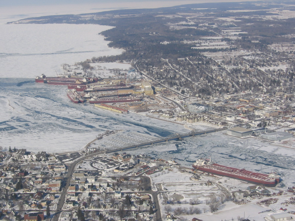


Sturgeon Bay, Wisconsin
Sturgeon Bay is a city of 9,806 people in Door County, Wisconsin.
Why visit Sturgeon Bay
Townapedia lists 36 museums and landmarks, 22 parks and trails, 30 places to eat, 21 places to stay and 5 attractions in and around town.
Highlights include Sturgeon Bay Canal North Pierhead Light, Sturgeon Bay Cinema, Louisiana Street/Seventh Avenue Historic District and Sturgeon Bay Post Office.
July is the warmest month, with average highs of 78°F; January lows average 10°F, and about 57 inches of snow fall in a normal year.
Weather in Sturgeon Bay
Forecast from the National Weather Service. Full forecast
About Sturgeon Bay
Sturgeon Bay is a city in Door County, Wisconsin, United States, and its county seat. The population was 9,646 at the 2020 census. Located at the bay of Sturgeon Bay for which it is named, it is the most populous city on the Door Peninsula, a popular Upper Midwest vacation destination.
From the Wikipedia article Sturgeon Bay, Wisconsin (this version), under CC BY-SA 4.0.
Things to do5

Sturgeon Bay Canal North Pierhead Light
Lighthouse · 3.6 mi
Lighthouse in Wisconsin, United States

Third Avenue PlayWorks
Cinema and theater · 1.0 mi
239 North 3rd Avenue, Sturgeon Bay
Museums and landmarks36

Louisiana Street/Seventh Avenue Historic District
Monument and historic site · National Register of Historic Places · 1.0 mi
Historic district in Wisconsin, United States

Sturgeon Bay Post Office
Monument and historic site · National Register of Historic Places · 0.9 mi
Main post office in Sturgeon Bay, Wisconsin

Third Avenue Historic District
Monument and historic site · National Register of Historic Places · 0.9 mi
Historic district in Sturgeon Bay, Wisconsin

Bullhead Point Historical and Archeological District
Monument and historic site · National Register of Historic Places · 1.9 mi
Archaeological site and shipwreck in Sturgeon Bay, Wisconsin

Carnegie Free Library
Monument and historic site · National Register of Historic Places · 0.9 mi
Carnegie library in Sturgeon Bay, Wisconsin, United States

Joys
Monument and historic site · National Register of Historic Places · 2.2 mi
Steamboat that sank in Lake Michigan


Sturgeon Bay Bridge
Bridge · National Register of Historic Places · 0.8 mi
Historic bridge in Sturgeon Bay, Wisconsin

Sturgeon Bay Canal Light
Lighthouse · National Register of Historic Places · 3.4 mi
Lighthouse in Wisconsin, United States

Teweles and Brandeis Grain Elevator
Monument and historic site · National Register of Historic Places · 0.8 mi
Grain elevator in Sturgeon Bay, Wisconsin


L. A. Larson & Co. Store
Monument and historic site · National Register of Historic Places · 0.7 mi
Robertson's Orchard
Monument and historic site · 1.9 mi
2575 Shiloh Road
Mo-Fr 10:00-17:00; Sa 09:00-17:00; Su 09:00-16:00
24 more on the map.
Parks, trails and playgrounds22




10 more on the map.
Restaurants and cafes30


The Corner Cafe
Restaurant · 0.9 mi
113 North 3rd Avenue, Sturgeon Bay
Su-Sa 05:00-14:00
Kitty O'Reillys Irish Pub
Restaurant · Coffee Shop · 0.7 mi
59 East Oak Street, Sturgeon Bay
18 more on the map.
History
The area was originally inhabited by the Ho-Chunk and Menominee. The town is known in the Menominee language as Namāēw-Wīhkit, or "bay of the sturgeon". The Menominee ceded this territory to the United States in the 1831 Treaty of Washington. After that, the area was available for white settlement.
The community was first recorded as Graham in 1855, but in 1857, the state legislature organized it as the town of Ottumba. Subsequently, the name was reverted to Graham, and in 1860, a petition was submitted to the county board to change the community's name to that of the adjacent bay. A company of volunteer firefighters was established in 1869. In 1874, Sturgeon Bay was incorporated as a village. It became a city in 1883, and the police department was founded that year. In 1891, Charles Mitchell Whiteside, a member of the Wisconsin Assembly, sponsored a bill that merged the community of Sawyer with Sturgeon Bay.
The city is locally known for the Sturgeon Bay Bridge at Michigan Street, which at the time of its 1931 opening was the second across the bay and carried the former route of WIS 17 (now WIS 42 and WIS 57/78).
Sturgeon Bay was one of a number of cities in the Midwest to assist with production during World War II. In 1943, many streets received new names. The former names of some streets are stenciled into older sidewalks.
From the History section of Sturgeon Bay, Wisconsin on Wikipedia, under CC BY-SA 4.0.
Where to stay21
AmericInn by Wyndham Sturgeon Bay
Motel and hotel · 1.6 mi
622 South Ashland Avenue, Sturgeon Bay
Bridgeport Waterfront Resort
Motel and hotel · 1.0 mi
50 West Larch Street, Sturgeon Bay
Churches and places of worship1
Corpus Christi Catholic Parish
Church · Roman Catholic · 1.4 mi
811 West Juniper Street, Sturgeon Bay
Shopping11
Gas and EV charging8
Schools, colleges and libraries12
Northeast Wisconsin Technical College- Sturgeon Bay
School · 1.2 mi
229 North 14th Avenue, Sturgeon Bay
Healthcare3
Aurora Health Center
Clinic and pharmacy · 2.2 mi
1910 Alabama Street, Sturgeon Bay
Map of Sturgeon Bay
149 places. The map loads OpenStreetMap tiles when you open it.
Climate by month
Monthly table
| Month | High | Low | Rain | Snow |
|---|---|---|---|---|
| Jan | 25°F | 10°F | 1.7 in | 15.6 in |
| Feb | 28°F | 12°F | 1.3 in | 12.9 in |
| Mar | 38°F | 21°F | 1.9 in | 8.6 in |
| Apr | 50°F | 32°F | 3.1 in | 4.0 in |
| May | 62°F | 42°F | 3.3 in | 0.0 in |
| Jun | 73°F | 53°F | 4.1 in | 0.0 in |
| Jul | 78°F | 59°F | 3.6 in | 0.0 in |
| Aug | 77°F | 58°F | 3.3 in | 0.0 in |
| Sep | 69°F | 51°F | 3.1 in | 0.0 in |
| Oct | 56°F | 39°F | 3.2 in | 0.2 in |
| Nov | 42°F | 29°F | 2.2 in | 2.4 in |
| Dec | 31°F | 18°F | 2.0 in | 13.7 in |
U.S. Climate Normals 1991-2020 for Sturgeon Bay Exp Farm (4 mi away), NOAA NCEI.
People and cost of living
American Community Survey 5-year estimates, 2020-2024, U.S. Census Bureau. Estimates have margins of error, larger for small towns.
Disaster history
Door County has had 4 federal disaster declarations since 2000, most often for biologicals.
- 2020-04-04: Covid-19 Pandemic (Biological)
- 2020-03-13: Covid-19 (Biological)
- 2005-09-13: Hurricane Katrina Evacuation (Hurricane)
- 2001-01-24: Snow (Snowstorm)
OpenFEMA disaster declarations summaries.
Getting there and nearby towns
Door County Cherryland Airport (SUE) is the nearest airport with scheduled flights listed in OpenStreetMap, 2 miles away.
- Algoma 15 mi south, about 25 min by car
- Marinette 22 mi northwest, about 36 min by car
- Menominee 24 mi northwest, about 39 min by car
- Oconto 25 mi west, about 40 min by car
- Peshtigo 25 mi northwest, about 40 min by car
- Luxemburg 25 mi southwest, about 41 min by car
- Kewaunee 26 mi south, about 42 min by car
- Sister Bay 28 mi northeast, about 45 min by car
- Suamico 35 mi west, about 57 min by car
- Green Bay 37 mi southwest, about 59 min by car
Drive times are estimates from straight-line distance, not routes.
Local news
Headlines from INDB, the NEMICO news database.
Reviews, tips and questions
Loading what members have shared...
Sources and licences
- NCES EDGE (Public domain): public schools
- NOAA NCEI U.S. Climate Normals 1991-2020 (Public domain): climate by month
- OpenFEMA (Public domain): disaster declarations
- OpenStreetMap contributors (ODbL 1.0): places, airports, map data
- U.S. Census Bureau (Public domain): population, income, housing, education, commute
- Wikidata (CC0 1.0): elevation, founding date, time zone, website, landmarks and historic places
- Wikimedia Commons (see each image): photos
- Wikipedia (CC BY-SA 4.0): overview and history text
Photo credits
- Ships in Sturgeon Bay, christine, CC BY-SA 2.0
- Sturgeon Bay East, Fondycardinals, CC BY-SA 4.0
- Sturgeon Bay Bridge Fall 09 - panoramio, Corey Coyle, CC BY 3.0
- Bank of Sawyer Building (Bank of Sturgeon Bay), Madison Avenue and Oak Street, Sturgeon Bay, WI (54221721694), Warren LeMay from Chicago, IL, United States, CC BY-SA 2.0
- Sturgeon Bay Tower 4 - panoramio, Corey Coyle, CC BY 3.0
- Madison Avenue, Sturgeon Bay, WI (54221706719), Warren LeMay from Chicago, IL, United States, CC BY-SA 2.0
- Greetings from Sturgeon Bay and Door County, Wisconsin - Large Letter Postcard (7599233030), Steve Shook from Moscow, Idaho, USA, CC BY 2.0
- Sturgeon Bay Barn Wisconsin (31378763613), Tony Webster from Minneapolis, Minnesota, United States, CC BY-SA 2.0
- Greystone Castle, Madison Avenue and Maple Street, Sturgeon Bay, WI (54221722389), Warren LeMay from Chicago, IL, United States, CC BY-SA 2.0
- CenterPointe Yacht Services and Maple-Oregon Street Bridge Sturgeon Bay Wisconsin, BobbyLight, CC BY 2.0
- Track and roll on the Sturgeon Bay Bridge, Door County, Wisconsin, BobbbyLight, CC BY 2.0
- Tread on the edge of one of the rolls on the Sturgeon Bay Bridge, Door County, Wisconsin, BobbbyLight, CC BY 2.0
- Sturgeon Bay Bridge from East Side, TillmanJosh, CC BY-SA 4.0
- Sturgeon Bay Bridge, April 27th, 2019, SigmaJosh, CC BY-SA 4.0
- Sturgeon Bay Bridge, April 26th, 2019, SigmaJosh, CC BY-SA 4.0
- Sturgeon Bay Bridge from north (2013), Richie Diesterheft from Chicago, IL, USA, CC BY-SA 2.0
- Bascule span of Sturgeon Bay Bridge (2013), Richie Diesterheft from Chicago, IL, USA, CC BY-SA 2.0
- Sturgeon Bay Tower 1 - panoramio, Corey Coyle, CC BY 3.0
- Clouds over Sturgeon Bay, TillmanJosh, CC BY-SA 4.0
- St Joseph's Roman Catholic Church (Sturgeon Bay, Wisconsin), TillmanJosh, CC BY-SA 4.0
- Sturgeon Bay Bridge in August 2020, TillmanJosh, CC BY-SA 4.0
- Sturgeon Bay Bridge at Sunset, TillmanJosh, CC BY-SA 4.0
- St. Joseph Catholic Church Sturgeon Bay, WI - panoramio, Corey Coyle, CC BY 3.0
- Otumba Park, city of Sturgeon Bay, Door County, Wisconsin, Bart Everson, CC BY 2.0
- Sturgeon Bay Tower 2 - panoramio, Corey Coyle, CC BY 3.0
- Sturgeon Bay Tower 3 - panoramio, Corey Coyle, CC BY 3.0
- SturgeonBayWisconsinPostOffice, Royalbroil, CC BY-SA 3.0
- LouisianaStreetSeventhAvenueHistoricDistrictSturgeonBayWisconsinStJosephsCatholicChurch, Royalbroil, CC BY-SA 3.0
- ThirdAvenueHistoricDistrictSturgeonBayWisconsin, Royalbroil, CC BY-SA 3.0
- Door County Trip - June 2013 - Sturgeon Bay Ship Canal Light (9209950418), Pete Markham from Loretto, USA, CC BY-SA 2.0
- Empire State ship, Milwaukee Public Library, Public domain
- SunsetParkSturgeonBayWisconsinJOYSShipwreck, Royalbroil, CC BY-SA 3.0
- CarnegieFreeLibrarySturgeonBayWisconsin, Royalbroil, CC BY-SA 3.0
- Sturgeon Bay Bridge, Flickr user mbaylor, CC BY 2.0
- Teweles and Brandeis Grain Elevator 1903, Christie M Weber, CC BY-SA 4.0
- L.A.LarsenStoreSturgeonBayWisconsin, Royalbroil, CC BY-SA 3.0
- Channel Light Sturgeon Bay Wisconsin, Greg Tally - User: (WT-shared) WineCountryInn at wts wikivoyage, CC BY-SA 3.0
- Emergency Response Exercise (37204169736), U.S. Fish and Wildlife Service - Midwest Region, Public domain
- ErieHackleywreckage, Skiba, Justin M., CC BY-SA 4.0
- Door County Maritime Museum, McGhiever, CC BY-SA 4.0


Page built October 30, 2026. Spotted a mistake? Tell us or suggest a place.