


Adıyaman, Turkey
Adıyaman is a regional capital of 290,883 people in Adıyaman Province, Turkey.
Why visit Adıyaman
Townapedia lists 12 museums and landmarks, 13 parks and trails, 42 places to eat, 12 places to stay and 8 attractions in and around town.
Highlights include Kara Dağ, Kemal Tepe, Adıyaman Archaeological Museum and Perrhe.
Weather in Adıyaman
Forecast from MET Norway (CC BY 4.0). Full forecast
About Adıyaman
Adıyaman (Kurdish: Semsûr) is a city in southeastern Turkey. It is the administrative centre of Adıyaman Province and Adıyaman District. Its population is 290,883 (2024). The inhabitants of the city are mostly Kurdish.
From the Wikipedia article Adıyaman (this version), under CC BY-SA 4.0.
Things to do8


Museums and landmarks12


Perrhe
Monument and historic site · 3.7 km
Ancient city of Lycia in modern-day Turkey


Parks, trails and playgrounds13



1 more on the map.
Restaurants and cafes42




30 more on the map.
History
The first settlement on the site of the city was the ancient town of Perrhe, part of the kingdom of Commagene before it became part of the Roman and later Byzantine Empire.
It was then captured by the Arabs and became known as Hisn Mansur. It became a contested border town between the Abbasid caliphate and the Byzantines and was therefore well protected; a wall with three gates and a ditch guarded the town while in its middle stood a fortress with double walls.
In the early eleventh century, the town formed part of the Byzantine defences in the Euphrates region together with Edessa, Gargar, Samosata and Chasanara. In 1066/1067, the region around the town was ravaged by a Turkish emir called Gümüshtekīn who took booty and captives. By the end of the eleventh century, the Byzantines had lost control of the town and it was now in possession of the Armenian local ruler Kogh Vasil.
From the History section of Adıyaman on Wikipedia, under CC BY-SA 4.0.
Where to stay12
Churches and places of worship35
Shopping28
Gas and EV charging22
SHARZ Bera Akaryakıt
EV charging · 3.6 km
Sümerevler Mahallesi, 17165. Sk. No:13, 02030 Adıyaman Merkez/Ad, ADIYAMAN MERKEZ
Schools, colleges and libraries68
Healthcare111
Map of Adıyaman
250 places. The map loads OpenStreetMap tiles when you open it.
Getting there and nearby towns
Adıyaman Airport (ADF) is the nearest airport with scheduled flights listed in OpenStreetMap, 17 km away.
- Zey 4 km northwest, about 4 min by car
- Altınşehir 5 km southwest, about 5 min by car
- Zey 5 km northwest, about 5 min by car
- Beşyol 5 km southeast, about 5 min by car
- Bağdere 7 km west, about 7 min by car
- Çemberlitaş 8 km northeast, about 8 min by car
- Hasankendi 8 km southwest, about 8 min by car
- Kayaönü 9 km northwest, about 9 min by car
- Yarmakaya 11 km southwest, about 11 min by car
- Rezip 12 km north, about 12 min by car
Drive times are estimates from straight-line distance, not routes.
Local news
Headlines from INDB.
Reviews, tips and questions
Loading what members have shared...
Sources and licences
- GeoNames (CC BY 4.0): population, coordinates, regions and time zone
- Mapillary (see each image): photos
- OpenStreetMap contributors (ODbL 1.0): places, airports, map data
- Wikidata (CC0 1.0): elevation, founding date, time zone, website, landmarks and historic places
- Wikimedia Commons (see each image): photos
- Wikipedia (CC BY-SA 4.0): overview and history text
Photo credits
- AdiyamanView, Vav, CC BY-SA 4.0
- Adıyaman spor - panoramio, fbrh01907, CC BY 3.0
- Adıyaman İsias otel enkazı 2, Mahmut Bozarslan, Public domain
- Adıyaman İsias otel enkazı 3, Mahmut Bozarslan, Public domain
- Adıyaman İsias otel enkazı 1, Mahmut Bozarslan, Public domain
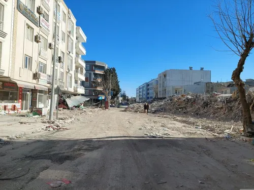
- Damage of the 2023 Gaziantep-Kahramanmaraş earthquakes in Adıyaman 07, Mahmut Bozarslan, Public domain
- Adıyaman, Adıyaman Merkez-Adıyaman Province, Turkey - panoramio, Ben Bender, CC BY-SA 3.0
- Adıyaman, Adıyaman Merkez-Adıyaman Province, Turkey - Banner, Ben Bender, CC BY-SA 3.0
- Adıyaman, Adıyaman Merkez-Adıyaman Province, Turkey - panoramio (1), Ben Bender, CC BY-SA 3.0
- Glazed Vessels, Adıyaman Archaeological Museum, - Ozymandias -, CC BY-SA 4.0
- Adıyaman Archaeological Museum, - Ozymandias -, CC BY-SA 4.0
- Adıyaman, Radosław Botev, CC BY 3.0 pl
- Damage of the 2023 Gaziantep-Kahramanmaraş earthquakes in Adıyaman 14, Mahmut Bozarslan, Public domain
- Damage of the 2023 Gaziantep-Kahramanmaraş earthquakes in Adıyaman 19, Mahmut Bozarslan, Public domain
- Damage of the 2023 Gaziantep-Kahramanmaraş earthquakes in Adıyaman 18, Mahmut Bozarslan, Public domain
- Damage of the 2023 Gaziantep-Kahramanmaraş earthquakes in Adıyaman 09, Mahmut Bozarslan, Public domain
- Damage of the 2023 Gaziantep-Kahramanmaraş earthquakes in Adıyaman 11, Mahmut Bozarslan, Public domain
- Damage of the 2023 Gaziantep-Kahramanmaraş earthquakes in Adıyaman 13, Mahmut Bozarslan, Public domain
- Damage of the 2023 Gaziantep-Kahramanmaraş earthquakes in Adıyaman 02, Mahmut Bozarslan, Public domain
- Damage of the 2023 Gaziantep-Kahramanmaraş earthquakes in Adıyaman 08, Mahmut Bozarslan, Public domain
- Damage of the 2023 Gaziantep-Kahramanmaraş earthquakes in Adıyaman 03, Mahmut Bozarslan, Public domain
- Perrhe1, Klaus-Peter Simon, CC BY-SA 3.0
- Museum Adıyaman Außenansicht, Ingeborg Simon, CC BY-SA 3.0
- Adıyaman Atatürk Stadyumu Ana Tribün, Lugano1997, CC BY-SA 4.0
- Adiyamankabcami, Vav, CC BY-SA 4.0
- Adyamanulucami, Vav, CC BY-SA 4.0
- Yenipinar Mosque 02, Bernard Gagnon, CC BY-SA 3.0
- Adiyaman, Turkey 01, Bernard Gagnon, CC BY-SA 3.0
- Adiyaman, Turkey 03, Bernard Gagnon, CC BY-SA 3.0
- Adiyaman, Turkey 02, Bernard Gagnon, CC BY-SA 3.0
- Necabettin Ergenekon (1980), Mstafasayar, CC BY 4.0
- OZDEMIR BILGISAYAR -90(416) 214 95 44 - panoramio - mirsoft, mirsoft, CC BY-SA 3.0
- OZDEMIR BILGISAYAR -90(416) 214 95 44 - panoramio - mirsoft (1), mirsoft, CC BY-SA 3.0
- OZDEMIR BILGISAYAR -90(416) 214 95 44 - panoramio, mirsoft, CC BY-SA 3.0
- OZDEMIR BILGISAYAR -90(416) 214 95 44 - panoramio - mirsoft (2), mirsoft, CC BY-SA 3.0
- Yenipinar Mosque 01, Bernard Gagnon, CC BY-SA 3.0
- Adiyamanyenipinarcami, Vav, CC BY-SA 4.0
- Adiyamansirepazari, Vav, CC BY-SA 4.0
- Adiyamankale2, Vav, CC BY-SA 4.0
- Eskisaraycami, Vav, CC BY-SA 4.0
- Adıyaman castle, Vav, CC BY-SA 4.0
- Street-level photo, musakrmn, CC BY-SA 4.0
- Street-level photo, musakrmn, CC BY-SA 4.0


Page built November 8, 2026. Spotted a mistake? Tell us or suggest a place.