


Why visit Bafra
Townapedia lists 1 museum or landmark, 4 parks and trails and 1 place to eat in and around town.
Highlights include Gadilon.
Weather in Bafra
Forecast from MET Norway (CC BY 4.0). Full forecast
About Bafra
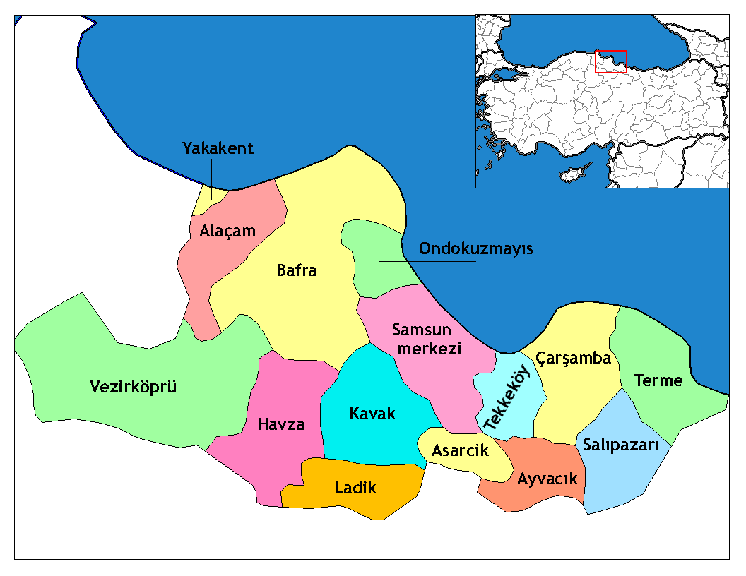
Bafra is a municipality and district of Samsun Province, Turkey. Covering about 1,500 km2, and with over 140,000 inhabitants it is a settlement located 20 kilometres (12 mi) from the Black Sea, in the fertile Kızılırmak Delta. The Bafra Plain is famous in Turkey for its rich soil and high quality tobacco growing conditions. The city is well known in Turkey for its ice cream, cigarettes, tobacco and agricultural produce.
From the Wikipedia article Bafra (this version), under CC BY-SA 4.0.
Museums and landmarks1

Gadilon
Monument and historic site · 0.8 km
Ancient city of Pontus in modern-day Turkey
Parks, trails and playgrounds4


Restaurants and cafes1

Churches and places of worship10

Kahraman Bahçeli Camii
Place of worship · Sunni · 1.6 km
2 Hacı Bayram Veli Sokak, Samsun
History
The name of the municipality is thought to have come from the Phoenician name "bafira" or "bavra". Other beliefs about the etymology of the region come from the name "Ba-Hura" (Great River) given to Kizilirmak which generates the delta upon which the city is located. Historical records of human settlement in Bafra and the Kizilirmak delta date to as early as 5000 BC.
The region came under the rule of the Rome who renamed the area Gadilon and later Helega. After the Fall of the Western Roman Empire, the area became part of the Byzantine Empire. The region was a part of the Byzantine Empire until the Battle of Manzikert in 1071. After that battle, Bafra was captured by the Anatolian Seljuk Ruler Kaykaus I. After being conquered by the Seljuk Empire the region was repopulated by members of various Turkmen tribes. The invasion of the Mongol Empire began in 1243 and led to the collapse of Seljuk Empire and the establishment of scattered Turkish principalities. During this period, the Bafra Principality was briefly established. This political arrangement continued until 1460, when Bafra was again conquered and made part of the Ottoman Empire.
From the History section of Bafra on Wikipedia, under CC BY-SA 4.0.
Shopping4
Gas and EV charging7
Schools, colleges and libraries2
Healthcare8
Map of Bafra
37 places. The map loads OpenStreetMap tiles when you open it.
Getting there and nearby towns
Ondokuz Mayıs Havaalanı (NIL) is the nearest airport with scheduled flights listed in OpenStreetMap, 19 km away.
- Yakakent 32 km west, about 32 min by car
- Çatkaya 43 km southeast, about 43 min by car
- Samsun 48 km southeast, about 48 min by car
- Kabalı 49 km southwest, about 49 min by car
- Kavak 56 km south, about 56 min by car
- Oymaağaç 56 km southwest, about 56 min by car
- Vezirköprü 60 km southwest, about 1 h by car
- Tekkeköy 61 km southeast, about 1 h by car
- Havza 69 km south, about 1 h 15 min by car
- Merzifon 86 km southwest, about 1 h 30 min by car
Drive times are estimates from straight-line distance, not routes.
Local news
Headlines from INDB.
Reviews, tips and questions
Loading what members have shared...
Sources and licences
- GeoNames (CC BY 4.0): population, coordinates, regions and time zone
- Mapillary (see each image): photos
- OpenStreetMap contributors (ODbL 1.0): places, airports, map data
- Wikidata (CC0 1.0): elevation, founding date, time zone, website, landmarks and historic places
- Wikimedia Commons (see each image): photos
- Wikipedia (CC BY-SA 4.0): overview and history text
Photo credits
- Samsun districts, Rarelibra, CC BY-SA 2.5
- Bafra - panoramio (34), sami yılmaz, CC BY 3.0
- Bafra - panoramio (40), sami yılmaz, CC BY 3.0
- Bafra - panoramio (36), sami yılmaz, CC BY 3.0
- Bafra - panoramio (41), sami yılmaz, CC BY 3.0
- Bafra - panoramio (35), sami yılmaz, CC BY 3.0
- Bafra - panoramio (42), sami yılmaz, CC BY 3.0
- Bafra Sunflower - panoramio (1), sami yılmaz, CC BY 3.0
- Bafra - panoramio (33), sami yılmaz, CC BY 3.0
- Bafra Sunflower - panoramio, sami yılmaz, CC BY 3.0
- Bafra - panoramio (26), sami yılmaz, CC BY 3.0
- Bafra da kar - panoramio (16), sami yılmaz, CC BY 3.0
- Bafra da kar - panoramio (23), sami yılmaz, CC BY 3.0
- Bafra da kar - panoramio (25), sami yılmaz, CC BY 3.0
- Bafra Çetinkaya Köprüsü - panoramio (4), sami yılmaz, CC BY 3.0
- Bafra da kar - panoramio (18), sami yılmaz, CC BY 3.0
- Bafra - panoramio (32), sami yılmaz, CC BY 3.0
- Bafra Çetinkaya Köprüsü - panoramio (7), sami yılmaz, CC BY 3.0
- Bafra da kar - panoramio (24), sami yılmaz, CC BY 3.0
- Bafra Çetinkaya Köprüsü - panoramio (2), sami yılmaz, CC BY 3.0
- Bafra - panoramio (27), sami yılmaz, CC BY 3.0
- Bafra Çetinkaya Köprüsü - panoramio (3), sami yılmaz, CC BY 3.0
- Bafra da kar - panoramio (17), sami yılmaz, CC BY 3.0
- Bafra Çetinkaya Köprüsü - panoramio (5), sami yılmaz, CC BY 3.0
- Bafra Çetinkaya Köprüsü - panoramio (11), sami yılmaz, CC BY 3.0
- Bafra da kar - panoramio (22), sami yılmaz, CC BY 3.0
- Bafra da kar - panoramio (14), sami yılmaz, CC BY 3.0
- Bafra Çetinkaya Köprüsü - panoramio (1), sami yılmaz, CC BY 3.0
- Windflower - panoramio, sami yılmaz, CC BY 3.0
- Windflower - panoramio (2), sami yılmaz, CC BY 3.0
- Windflower - panoramio (6), sami yılmaz, CC BY 3.0
- Windflower - panoramio (1), sami yılmaz, CC BY 3.0
- Untitled, Melih Kaya, CC BY 3.0
- Windflower - panoramio (3), sami yılmaz, CC BY 3.0
- Windflower - panoramio (9), sami yılmaz, CC BY 3.0
- Windflower - panoramio (4), sami yılmaz, CC BY 3.0
- Windflower - panoramio (7), sami yılmaz, CC BY 3.0
- Flower - panoramio (49), sami yılmaz, CC BY 3.0
- Windflower - panoramio (10), sami yılmaz, CC BY 3.0
- Windflower - panoramio (5), sami yılmaz, CC BY 3.0
- Street-level photo, 12volt, CC BY-SA 4.0
- Street-level photo, 12volt, CC BY-SA 4.0
- Street-level photo, ozkanilyasaksu, CC BY-SA 4.0
- Street-level photo, ozkanilyasaksu, CC BY-SA 4.0
- Street-level photo, ozkanilyasaksu, CC BY-SA 4.0
- Street-level photo, ozkanilyasaksu, CC BY-SA 4.0


Page built November 8, 2026. Spotted a mistake? Tell us or suggest a place.