


Why visit Iğdır
Townapedia lists 3 museums and landmarks, 4 parks and trails, 1 place to eat, 3 places to stay and 1 attraction in and around town.
Highlights include Armavir, Iğdır Genocide Memorial and Museum and Iğdır Şehir Stadyumu.
Weather in Iğdır
Forecast from MET Norway (CC BY 4.0). Full forecast
About Iğdır
Iğdır (Turkish: [ˈɯːdɯɾ] ; Armenian: Իգդիր, romanized: Igdir or Ցոլակերտ, Tsʿolakert; Azerbaijani: İğdır; Kurdish: Îdir or Reşqelas) is a city in the Eastern Anatolia region of Turkey. It is the seat of Iğdır Province and Iğdır District. Its population is 101,700 (2022).
From the Wikipedia article Iğdır (this version), under CC BY-SA 4.0.
Things to do1

Museums and landmarks3

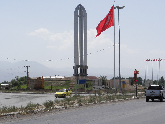
Iğdır Genocide Memorial and Museum
Museum · 3.3 km
Museum in Iğdır District

Ermeniler Tarafından Katledilen Şehit Türkler Anıtı
Monument and historic site · 3.3 km
Parks, trails and playgrounds4




Restaurants and cafes1

Seyir Cafe
Fast food · Pizza, Coffee Shop, Burger, Chicken, Ice Cream, Breakfast · 12.9 km
Iğdır Üniversitesi İç Yolu, Iğdır
Mo-Su 09:00-22:00
History
Iğdır went by the Armenian name of Tsolakert during the Middle Ages. When the Spanish traveler Ruy González de Clavijo passed through this region in the early 15th century, he stayed a night in a castle he called Egida, located at the foot of Mount Ararat. Clavijo describes it as being built upon a rock and ruled by a woman, the widow of a brigand that Timur had put to death. Because modern Iğdır has no such rock, and is a considerable distance from the Ararat foothills, it is believed that medieval Iğdır was located at a different site, at a place also known as Tsolakert, now called Taşburun. Russian excavations there at the end of the 19th century discovered the ruins of houses and what was identified as a church, as well as traces of fortifications. The settlement may have been abandoned after an earthquake in 1664. In 1555 the town became a part of the Safavid Empire, remaining under Persian rule (with brief military occupations by the Ottomans in 1514, between 1534–35, 1548–49, 1554–55, 1578–1605, 1635–36 and 1722–46) until it fell into the hands of the Russian Empire after the Russo-Persian War of 1826-1828.
From the History section of Iğdır on Wikipedia, under CC BY-SA 4.0.
Where to stay3
Churches and places of worship7
Shopping6
Gas and EV charging3
Schools, colleges and libraries15
Healthcare53
Map of Iğdır
96 places. The map loads OpenStreetMap tiles when you open it.
Getting there and nearby towns
Iğdır Airport (IGD) is the nearest airport with scheduled flights listed in OpenStreetMap, 15 km away.
- Enginalan 4 km north, about 4 min by car
- Melekli 5 km northeast, about 5 min by car
- Aşağıerhacı 5 km southeast, about 5 min by car
- Obaköy 5 km northwest, about 5 min by car
- Halfeli 6 km southwest, about 6 min by car
- Karakuyu 6 km south, about 6 min by car
- Panik 7 km north, about 7 min by car
- Hoşhaber 7 km west, about 7 min by car
- Yaycı 7 km northwest, about 7 min by car
- Ağrı 89 km west, about 1 h 30 min by car
Drive times are estimates from straight-line distance, not routes.
Local news
Headlines from INDB.
Reviews, tips and questions
Loading what members have shared...
Sources and licences
- GeoNames (CC BY 4.0): population, coordinates, regions and time zone
- Mapillary (see each image): photos
- OpenStreetMap contributors (ODbL 1.0): places, airports, map data
- Wikidata (CC0 1.0): elevation, founding date, time zone, website, landmarks and historic places
- Wikimedia Commons (see each image): photos
- Wikipedia (CC BY-SA 4.0): overview and history text
Photo credits
- Iğdır ve Ağrı Dağı, Sabri76, CC0
- Iğdır dan ağrı dağı - panoramio, mhasras, CC BY 3.0
- Iğdır at night, Sabri76, Public domain
- Iğdır Pagebanner, Sabri76, CC0
- Iğdır Dsi yolu, Fotoğrafçı Abbas, CC BY-SA 4.0
- Iğdır gün batarken... - panoramio, mhasras, CC BY 3.0
- SoykırımAnıtMüze5, Sabri76, Public domain
- Iğdır Şehir Stadyumu, Sabri76, Public domain
- Igdir-sehir-stadyumu-1.2025, Iğdırfutbol, CC0
- IĞDIR ÇAY BAHÇELERİ - panoramio, yeşilgüzelığdır, CC BY 3.0
- 1990 DÜNYA LİSELER ARASI FOLKLOR ŞAMPİYONU IĞDIR LİSESİ - panoramio, yeşilgüzelığdır, CC BY 3.0
- 29 EKİM 1989 CUMHURİYET BAYRAMI IĞDIR - panoramio, yeşilgüzelığdır, CC BY 3.0
- 29 EKİM 1989 CUMHURİYET BAYRAMI IĞDIR - panoramio (1), yeşilgüzelığdır, CC BY 3.0
- IĞDIR SEGİO KOKOREÇ - panoramio, yeşilgüzelığdır, CC BY 3.0
- IĞDIR HACI YUSUF HACER CAMİİ 1990 YAPIMI - panoramio, yeşilgüzelığdır, CC BY 3.0
- IĞDIR VALİ YOLU - panoramio, yeşilgüzelığdır, CC BY 3.0
- IĞDIR VALİ YOLU VE AĞRI DAĞI - panoramio, yeşilgüzelığdır, CC BY 3.0
- Igdir - panoramio, iran culture, CC BY-SA 3.0
- Great Ararat with full moon in Igdir 03, Berserkcasca, CC BY-SA 4.0
- Great Ararat with full moon in Igdir 02, Berserkcasca, CC BY-SA 4.0
- IĞDIR VALİ YOLU AFACAN ÇOCUK MERKEZİ - panoramio, yeşilgüzelığdır, CC BY 3.0
- IĞDIR VALİ YOLU AKŞAMLARI - panoramio, yeşilgüzelığdır, CC BY 3.0
- IĞDIR TOPRAK MAHSULLERİ OFİSİ - panoramio, yeşilgüzelığdır, CC BY 3.0
- IĞDIR GÖKKUŞAĞI - panoramio, yeşilgüzelığdır, CC BY 3.0
- IĞDIR GÖKKUŞAĞI - panoramio (5), yeşilgüzelığdır, CC BY 3.0
- IĞDIR GÖKKUŞAĞI - panoramio (2), yeşilgüzelığdır, CC BY 3.0
- IĞDIR GÖKKUŞAĞI - panoramio (11), yeşilgüzelığdır, CC BY 3.0
- IĞDIR GÖKKUŞAĞI - panoramio (1), yeşilgüzelığdır, CC BY 3.0
- IĞDIR GÖKKUŞAĞI - panoramio (3), yeşilgüzelığdır, CC BY 3.0
- IĞDIR GÖKKUŞAĞI - panoramio (4), yeşilgüzelığdır, CC BY 3.0
- IĞDIR GÖKKUŞAĞI - panoramio (8), yeşilgüzelığdır, CC BY 3.0
- IĞDIR GÖKKUŞAĞI - panoramio (10), yeşilgüzelığdır, CC BY 3.0
- IĞDIR GÖKKUŞAĞI - panoramio (6), yeşilgüzelığdır, CC BY 3.0
- IĞDIR GÖKKUŞAĞI - panoramio (9), yeşilgüzelığdır, CC BY 3.0
- IĞDIR GÖKKUŞAĞI - panoramio (7), yeşilgüzelığdır, CC BY 3.0
- IĞDIR LEYLEKLER HEYKELİ - panoramio, yeşilgüzelığdır, CC BY 3.0
- HAKVEYİS KUM OCAĞI - panoramio, yeşilgüzelığdır, CC BY 3.0
- Hakveyis kavşağı nağıbeyim - panoramio, carsigdir, CC BY-SA 3.0
- Nağıbeyim - panoramio, carsigdir, CC BY-SA 3.0
- Nağı beyim - panoramio, carsigdir, CC BY-SA 3.0
- Armenian Ancient capital Armavir - panoramio (3), sedrakGr, CC BY 3.0
- Street-level photo, healixx, CC BY-SA 4.0
- Street-level photo, healixx, CC BY-SA 4.0
- Street-level photo, healixx, CC BY-SA 4.0
- Street-level photo, healixx, CC BY-SA 4.0
- Street-level photo, healixx, CC BY-SA 4.0
- Street-level photo, healixx, CC BY-SA 4.0


Page built November 8, 2026. Spotted a mistake? Tell us or suggest a place.