


Why visit Kırşehir
Townapedia lists 13 museums and landmarks, 23 parks and trails, 6 places to eat, 5 places to stay and 1 attraction in and around town.
Highlights include Aquae Saravenae, Aşık Pasha Mausoleum and Ahi Stadyumu.
Weather in Kırşehir
Forecast from MET Norway (CC BY 4.0). Full forecast
About Kırşehir
Kırşehir is a city in Turkey. It is the seat of Kırşehir Province and Kırşehir District. Its population is 162,989 (2023).
From the Wikipedia article Kırşehir (this version), under CC BY-SA 4.0.
Travel tips from other travellers: Kırşehir on Wikivoyage (CC BY-SA 4.0).
Things to do1

Museums and landmarks13

Aquae Saravenae
Monument and historic site
Ancient city of Cappadocia in modern-day Turkey

Aşık Pasha Mausoleum
Monument and historic site · 0.8 km
Türbe (Islamic mausoleum) in Turkey
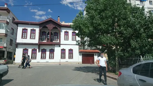

İmaret Camii-Şeyh Süleyman Hazretleri Türbesi
Monument and historic site · 0.8 km
1 more on the map.
Parks, trails and playgrounds23

11 more on the map.
Restaurants and cafes6





History
The history of Kırşehir dates back to the Hittites. During the period of the Hittites, the basin of Kırşehir was known as the country of "Ahiyuva", meaning "the Land of the Achaeans", as the Greeks were known to the Hittites. This basin also took the name Cappadocia at the time of the Romans and Byzantines.
Kırşehir was once known as Aquae Saravenae. The Seljuks took the city in the 1070s and bestowed the current name. In Turkish, "Kır Şehri" means "steppe city" or "prairie city". It became the chief town of a sanjak in the Ottoman vilayet of Angora, which possessed, c. 1912, 8,000 inhabitants, most of them Muslim Turks.
In the 19th century, Kırşehir was attached to the sanjak of Ankara. From 1867 until 1922, Kırşehir was part of Angora vilayet. In 1924, Kırşehir was made capital of the new Kırşehir Province. Mustafa Kemal Atatürk visited the city in 1921 and 1931.
From the History section of Kırşehir on Wikipedia, under CC BY-SA 4.0.
Where to stay5
Churches and places of worship36
Shopping25
Gas and EV charging2
Schools, colleges and libraries16
Healthcare59
Map of Kırşehir
186 places. The map loads OpenStreetMap tiles when you open it.
Getting there and nearby towns
Nevşehir Kapadokya Airport (NAV) is the nearest airport with scheduled flights listed in OpenStreetMap, 52 km away.
- Mucur 21 km southeast, about 21 min by car
- Devedamı 27 km southwest, about 27 min by car
- Boğazköy 32 km southwest, about 32 min by car
- Sarıyahşi 33 km southwest, about 33 min by car
- Ağaçören 37 km southwest, about 37 min by car
- Hacıbektaş 41 km southeast, about 41 min by car
- Bozkır 40 km south, about 40 min by car
- Sarıkaraman 42 km south, about 42 min by car
- Kaman 45 km northwest, about 45 min by car
- Ortaköy 47 km south, about 47 min by car
Drive times are estimates from straight-line distance, not routes.
Local news
Headlines from INDB.
Reviews, tips and questions
Loading what members have shared...
Sources and licences
- GeoNames (CC BY 4.0): population, coordinates, regions and time zone
- Mapillary (see each image): photos
- OpenStreetMap contributors (ODbL 1.0): places, airports, map data
- Wikidata (CC0 1.0): elevation, founding date, time zone, website, landmarks and historic places
- Wikimedia Commons (see each image): photos
- Wikipedia (CC BY-SA 4.0): overview and history text
Photo credits
- Autumn on Lake Hilla - panoramio, Tevfik Teker, CC BY 3.0
- Kırşehir, Tevfik Teker, CC BY-SA 4.0
- Ahi Stadium 2013, BerlinKreuzberg36, CC BY-SA 3.0
- Cacabey, Omur Tanyel, CC BY-SA 3.0
- Aşık Paşa Türbesi - Tomb Of Ashik Pasha - panoramio, Tevfik Teker, CC BY 3.0
- Canopies - panoramio, Tevfik Teker, CC BY 3.0
- Canopies and the Cat - panoramio, Tevfik Teker, CC BY 3.0
- The Arch of The Light - panoramio, Tevfik Teker, CC BY 3.0
- The Arches of Ahmet Yesevi Mosque - panoramio, Tevfik Teker, CC BY 3.0
- Loneliness - panoramio (1), Tevfik Teker, CC BY 3.0
- Cacabey Medresesi 2, Kharkil, CC BY-SA 4.0
- Cacabey Medresesi, Kharkil, CC BY-SA 4.0
- Ahi Evran Mosque - panoramio, Tevfik Teker, CC BY 3.0
- Ahi Evran Mosque - panoramio (2), Tevfik Teker, CC BY 3.0
- Ahi Evran Mosque - panoramio (1), Tevfik Teker, CC BY 3.0
- Kent Park - panoramio, Tevfik Teker, CC BY 3.0
- Kentpark at Night - panoramio, Tevfik Teker, CC BY 3.0
- Parliement Swan - panoramio, Tevfik Teker, CC BY 3.0
- Inhabitants of Kent Park - panoramio, Tevfik Teker, CC BY 3.0
- Mist Over Kentpark - panoramio, Tevfik Teker, CC BY 3.0
- Tulips - panoramio (4), Tevfik Teker, CC BY 3.0
- Two Swans - panoramio, Tevfik Teker, CC BY 3.0
- Tulip Fields Forever - panoramio, Tevfik Teker, CC BY 3.0
- Fireplug Among Tulips - panoramio, Tevfik Teker, CC BY 3.0
- Tarkan ^ The Wolf - panoramio, Tevfik Teker, CC BY 3.0
- Kentpark 2, Tevfik Teker, CC BY-SA 4.0
- What If It Happens - panoramio, Tevfik Teker, CC BY 3.0
- Fountain of Tulip Period - panoramio, Tevfik Teker, CC BY 3.0
- Fireplug Among Tulips 2 - panoramio, Tevfik Teker, CC BY 3.0
- World of Tulips - panoramio, Tevfik Teker, CC BY 3.0
- Gondolas of Kentpark - panoramio, Tevfik Teker, CC BY 3.0
- Neşet Ertaş Kültür Merkezi, Tevfik Teker, CC BY-SA 4.0
- Hamidiye Camii 2, Kharkil, CC BY-SA 4.0
- Old Adobe House, Tevfik Teker, CC BY-SA 4.0
- Terme Thermal Springs, Kharkil, CC BY-SA 4.0
- Terme Thermal Springs 2, Kharkil, CC BY-SA 4.0
- Neşet Ertaş - panoramio, Tevfik Teker, CC BY 3.0
- Thermal Springs, Kharkil, CC BY-SA 4.0
- Rocky of Terme - panoramio, Tevfik Teker, CC BY 3.0
- Winter in Hilla Park - panoramio (2), Tevfik Teker, CC BY 3.0
- Street-level photo, kubikanber, CC BY-SA 4.0
- Street-level photo, mrgunen, CC BY-SA 4.0
- Street-level photo, kubikanber, CC BY-SA 4.0
- Street-level photo, kubikanber, CC BY-SA 4.0
- Street-level photo, kubikanber, CC BY-SA 4.0
- Street-level photo, hamidgf, CC BY-SA 4.0
- Street-level photo, kubikanber, CC BY-SA 4.0
- Street-level photo, empty, CC BY-SA 4.0
- Street-level photo, mrgunen, CC BY-SA 4.0
- Street-level photo, empty, CC BY-SA 4.0
- Street-level photo, mrgunen, CC BY-SA 4.0
- Street-level photo, mrgunen, CC BY-SA 4.0


Page built November 8, 2026. Spotted a mistake? Tell us or suggest a place.