


Why visit Şavşat
Townapedia lists 2 museums and landmarks, 2 parks and trails, 2 places to eat, 1 place to stay and 7 attractions in and around town.
Highlights include Kukula Tepesi, Pistehale Tepesi, Şavşat Castle and Şavşat Kalesi.
Weather in Şavşat
Forecast from MET Norway (CC BY 4.0). Full forecast
About Şavşat
Şavşat (Georgian: შავშეთი, romanized: shavsheti) is a town in Artvin Province in the Black Sea region, between the cities of Artvin and Kars on the border with Georgia at the far eastern end of Turkey. It is the seat of Şavşat District. Its population is 6,048 (2021).
From the Wikipedia article Şavşat (this version), under CC BY-SA 4.0.
Things to do7

Museums and landmarks2
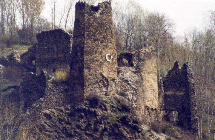
Şavşat Castle
Monument and historic site · 2.4 km
Castle near Şavşat in Turkey
Parks, trails and playgrounds2


Karagöl-Sahara National Park
Park · 8.1 km
National park and and wildlife refuge in Turkey
Restaurants and cafes2

History
According to Rayfield, in 790 BC, King Menua of Urartu invaded Shesheti in Kingdom of Diauehi, which is the Kartvelian province of Shavsheti.
In 387 this land was a part of Marzpan Iberia (vassal of Iran). After this, in IX century it was one of the Georgian princedoms in the constellation of several polities which is conventionally known as Tao-Klarjeti in Georgian. The princedom of Shavsheti included today's districts of Şavşat, Borçka, and Murgul in Turkey and Lower Machakheli in Adjara (Georgia). The fortress above the town is primarily of Georgian construction and probably dates from the 9th century A.D., when it was rebuilt by Adarnase I of Iberia. The site has an impressive circuit wall with strategically placed towers and rooms, including two small chapels. In 1983 the fortress was surveyed and three years later an accurate scaled plan and description were published.
Following the Russo-Turkish War (1877-1878) Şavşat was among the territories ceded to Russia, and was returned to the new Republic of Turkey in 1921. It was briefly bounded to Ardahan Province between 27 February 1921 and 7 July 1921. People living in Şavşat and Imerkhevi are a mix of Georgians, Turkified Georgians, and ethnic Turks (both Ottoman settlers, and earlier Cuman-Kipchak Turks (settled during medieval Georgian kingdom as mercenaries).
From the History section of Şavşat on Wikipedia, under CC BY-SA 4.0.
Where to stay1
Churches and places of worship5
Shopping5
Gas and EV charging1
Schools, colleges and libraries4
Healthcare6
Map of Şavşat
35 places. The map loads OpenStreetMap tiles when you open it.
Getting there and nearby towns
Kars Harakani Airport (KSY) is the nearest airport with scheduled flights listed in OpenStreetMap, 100 km away.
- Meydancık 20 km northwest, about 20 min by car
- Sulakyurt 25 km southeast, about 25 min by car
- Yalnızçam 24 km southeast, about 24 min by car
- Ardanuç 28 km southwest, about 28 min by car
- Çiçeklidağ 32 km east, about 32 min by car
- Ardahan 33 km southeast, about 33 min by car
- Koyunpınarı 36 km east, about 36 min by car
- Seyitler 44 km west, about 44 min by car
- Artvin 45 km west, about 45 min by car
- Hopa 80 km west, about 1 h 15 min by car
Drive times are estimates from straight-line distance, not routes.
Local news
Headlines from INDB.
Reviews, tips and questions
Loading what members have shared...
Sources and licences
- GeoNames (CC BY 4.0): population, coordinates, regions and time zone
- OpenStreetMap contributors (ODbL 1.0): places, airports, map data
- Wikidata (CC0 1.0): elevation, founding date, time zone, website, landmarks and historic places
- Wikimedia Commons (see each image): photos
- Wikipedia (CC BY-SA 4.0): overview and history text
Photo credits
- Şavşat1, Jaba1977, Attribution
- Şavşat 9 2011, Özgür Esen ( Surdurulebiliryasam ), CC BY-SA 4.0
- Şavşat 5 2011, Özgür Esen ( Surdurulebiliryasam ), CC BY-SA 4.0
- Şavşat 11 2011, Özgür Esen ( Surdurulebiliryasam ), CC BY-SA 4.0
- Şavşat 4 2011, Özgür Esen ( Surdurulebiliryasam ), CC BY-SA 4.0
- Şavşat 10 2011, Özgür Esen ( Surdurulebiliryasam ), CC BY-SA 4.0
- Şavşat 2 2011, Özgür Esen ( Surdurulebiliryasam ), CC BY-SA 4.0
- Şavşat 1 2011, Özgür Esen ( Surdurulebiliryasam ), CC BY-SA 4.0
- Şavşat 6 2011, Özgür Esen ( Surdurulebiliryasam ), CC BY-SA 4.0
- Şavşat 3 2011, Özgür Esen ( Surdurulebiliryasam ), CC BY-SA 4.0
- Şavşat 12 2011, Özgür Esen ( Surdurulebiliryasam ), CC BY-SA 4.0
- Şavşat 7 2011, Özgür Esen ( Surdurulebiliryasam ), CC BY-SA 4.0
- Şavşat 8 2011, Özgür Esen ( Surdurulebiliryasam ), CC BY-SA 4.0
- Efkar tepesi şavşat 4 2011, Özgür Esen ( Surdurulebiliryasam ), CC BY-SA 4.0
- Efkar tepesi şavşat 3 2011, Özgür Esen ( Surdurulebiliryasam ), CC BY-SA 4.0
- Efkar tepesi şavşat 2 2011, Özgür Esen ( Surdurulebiliryasam ), CC BY-SA 4.0
- Efkar tepesi şavşat 1 2011, Özgür Esen ( Surdurulebiliryasam ), CC BY-SA 4.0
- Şavşat - panoramio, Gürsoy Tokgöz, CC BY 3.0
- ŞAVŞAT LAŞET MOTEL - panoramio, hüseyin yeşil, CC BY 3.0
- Şavşat kalesi, Sairzamanlar, CC BY-SA 4.0
- Karagöl-Sahara National Park entrance, BSRF, CC BY-SA 4.0
- ტბეთი, 1888 - პავლინოვის ფოტო, პავლინოვ (Pavlinov), Public domain
- Karagöl in Şavşat 06, BSRF, CC BY-SA 4.0
- Tbeti Manastırı 2022-08-04 20.38.13 1790843115, Seymark, CC BY-SA 4.0
- Tbeti Manastırı 2022-08-04 17.43.31 1790843118, Seymark, CC BY-SA 4.0
- Tibet-Kilisesi, Tembelpanda, CC BY-SA 4.0
- Bağçecilerin mahallesi - panoramio, hakkitrz, CC BY 3.0
- ISS043-E-248575 - View of Earth, Earth Science and Remote Sensing Unit , Lyndon B. Johnson Space Center, Public domain
- ISS043-E-248574 - View of Earth, Earth Science and Remote Sensing Unit , Lyndon B. Johnson Space Center, Public domain
- ISS034-E-11102 - View of Earth, Earth Science and Remote Sensing Unit , Lyndon B. Johnson Space Center, Public domain
- ISS054-E-36306 - View of Earth, Earth Science and Remote Sensing Unit, NASA Johnson Space Center, Public domain
- Artvin ardahan yolu 4 2011, Özgür Esen ( Surdurulebiliryasam ), CC BY-SA 4.0
- Artvin ardahan yolu 5 2011, Özgür Esen ( Surdurulebiliryasam ), CC BY-SA 4.0
- Artvin ardahan yolu 3 2011, Özgür Esen ( Surdurulebiliryasam ), CC BY-SA 4.0
- Artvin ardahan yolu 2 2011, Özgür Esen ( Surdurulebiliryasam ), CC BY-SA 4.0
- Artvin ardahan yolu 6 2011, Özgür Esen ( Surdurulebiliryasam ), CC BY-SA 4.0
- Artvin ardahan yolu 1 2011, Özgür Esen ( Surdurulebiliryasam ), CC BY-SA 4.0
- Çamiyara - panoramio, hakkitrz, CC BY 3.0
- ISS019-E-6090 - View of Earth, Earth Science and Remote Sensing Unit , Lyndon B. Johnson Space Center, Public domain
- ISS019-E-6091 - View of Earth, Earth Science and Remote Sensing Unit , Lyndon B. Johnson Space Center, Public domain


Page built November 8, 2026. Spotted a mistake? Tell us or suggest a place.