


Trexlertown, Pennsylvania
Trexlertown is a community of 2,416 people in Lehigh County, Pennsylvania.
Why visit Trexlertown
Townapedia lists 3 museums and landmarks, 14 parks and trails, 44 places to eat, 4 places to stay and 2 attractions in and around town.
Highlights include Movie Tavern, Dorney Park & Wildwater Kingdom, George F. Schlicher Hotel and Lock Ridge Furnace Complex.
July is the warmest month, with average highs of 85°F; January lows average 20°F.
Weather in Trexlertown
Forecast from the National Weather Service. Full forecast
About Trexlertown
Trexlertown is an unincorporated community and census-designated place (CDP) in Upper Macungie Township, Pennsylvania. As of the 2020 census, the population was 2,382. It is part of the Lehigh Valley, which had a population of 861,899 and was the 68th-most populous metropolitan area in the U.S. as of the 2020 census, and lies between Breinigsville and Wescosville.
From the Wikipedia article Trexlertown, Pennsylvania (this version), under CC BY-SA 4.0.
Things to do2

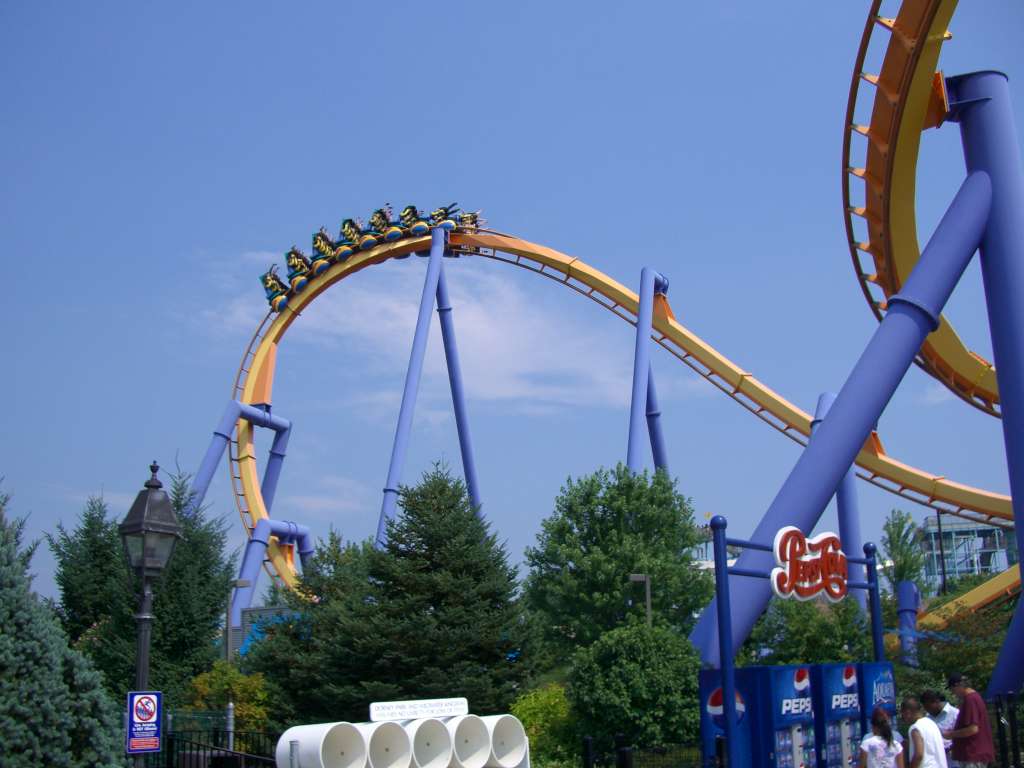
Dorney Park & Wildwater Kingdom
Monument and historic site · 3.5 mi
Amusement park in Pennsylvania
Museums and landmarks3

George F. Schlicher Hotel
Monument and historic site · National Register of Historic Places · 3.1 mi
Hotel in Pennsylvania, United States of America


Lock Ridge Furnace Complex
Monument and historic site · National Register of Historic Places · 3.3 mi
Historic buildings in Alburtis, Pennsylvania, United States

Parks, trails and playgrounds14



2 more on the map.
Restaurants and cafes44

Applebee's
Diner · American · 0.4 mi
7150 Hamilton Boulevard, Trexlertown
Mo-Th,Su 11:30-23:00; Fr-Sa 11:30-24:00

Friendly's
Diner · American · 0.4 mi
6894 Hamilton Boulevard, Trexlertown
Mo-Th,Su 11:00-21:00; Fr-Sa 11:00-22:00

Outback Steakhouse
Restaurant · American, Steak · 1.6 mi
800 North Krocks Road, Allentown
Mo-Th 11:00-21:30; Fr-Sa 11:00-22:30; Su 11:00-21:00

Rita's Italian Ice
Ice cream · Ice Cream · 1.4 mi
5681 Hamilton Boulevard, Wescosville
Mo-Su 12:00-21:00
3 Men & A Bagel
Cafe · 0.7 mi
7150 Hamilton Boulevard, Trexlertown
Mo-Fr 06:00-15:00; Sa 07:00-15:00; Su 07:00-14:00
32 more on the map.
History
Jeremiah Trexler obtained land adjoining that of his father in present-day Upper Macungie Township, where he operated a tavern as early as in 1732. Two years later, in 1734, a road was developed from his Upper Macungie Township tavern south through North Wales to Philadelphia.
As was the custom of the time, a village grew around the tavern, and the village came to be known as Trexlertown in honor of Trexler's role in its founding.
From the History section of Trexlertown, Pennsylvania on Wikipedia, under CC BY-SA 4.0.
Where to stay4
Victoriana Executive Suites
Motel and hotel · 0.8 mi
1027 Trexlertown Road, Trexlertown
Churches and places of worship5
Saint Paul's United Church of Christ
Church · United Church Of Christ · 1.0 mi
1249 Trexlertown Road, Trexlertown
Shopping11
Gas and EV charging9
Schools, colleges and libraries29
Healthcare2
Map of Trexlertown
123 places. The map loads OpenStreetMap tiles when you open it.
Climate by month
Monthly table
| Month | High | Low | Rain |
|---|---|---|---|
| Jan | 38°F | 20°F | 3.4 in |
| Feb | 41°F | 21°F | 2.8 in |
| Mar | 49°F | 28°F | 3.9 in |
| Apr | 62°F | 39°F | 4.1 in |
| May | 72°F | 48°F | 3.8 in |
| Jun | 80°F | 58°F | 4.5 in |
| Jul | 85°F | 62°F | 5.4 in |
| Aug | 83°F | 60°F | 4.4 in |
| Sep | 77°F | 53°F | 4.8 in |
| Oct | 65°F | 41°F | 4.3 in |
| Nov | 53°F | 32°F | 3.6 in |
| Dec | 42°F | 25°F | 3.8 in |
U.S. Climate Normals 1991-2020 for Rodale Rsch Ctr (7 mi away), NOAA NCEI.
People and cost of living
American Community Survey 5-year estimates, 2020-2024, U.S. Census Bureau. Estimates have margins of error, larger for small towns.
Disaster history
Lehigh County has had 11 federal disaster declarations since 2000, most often for hurricanes.
- 2020-03-30: Covid-19 Pandemic (Biological)
- 2020-03-13: Covid-19 (Biological)
- 2016-03-23: Severe Winter Storm And Snowstorm (Snowstorm)
- 2012-10-29: Hurricane Sandy (Hurricane)
- 2011-09-08: Remnants Of Tropical Storm Lee (Flood)
- 2011-09-03: Hurricane Irene (Hurricane)
OpenFEMA disaster declarations summaries.
Getting there and nearby towns
Lehigh Valley International Airport (ABE) is the nearest airport with scheduled flights listed in OpenStreetMap, 10 miles away.
- Ancient Oaks 1 mi south, about 2 min by car
- Breinigsville 2 mi southwest, about 4 min by car
- Cetronia 3 mi northeast, about 5 min by car
- Alburtis 3 mi south, about 6 min by car
- Macungie 4 mi southeast, about 6 min by car
- Dorneyville 4 mi east, about 7 min by car
- Emmaus 5 mi east, about 8 min by car
- Allentown 7 mi northeast, about 11 min by car
- Topton 7 mi southwest, about 11 min by car
- Fullerton 8 mi northeast, about 13 min by car
Drive times are estimates from straight-line distance, not routes.
Local news
Headlines from INDB, the NEMICO news database.
Reviews, tips and questions
Loading what members have shared...
Sources and licences
- NCES EDGE (Public domain): public schools
- NOAA NCEI U.S. Climate Normals 1991-2020 (Public domain): climate by month
- OpenFEMA (Public domain): disaster declarations
- OpenStreetMap contributors (ODbL 1.0): places, airports, map data
- U.S. Census Bureau (Public domain): population, income, housing, education, commute
- Wikidata (CC0 1.0): elevation, founding date, time zone, website, landmarks and historic places
- Wikimedia Commons (see each image): photos
- Wikipedia (CC BY-SA 4.0): overview and history text
Photo credits
- Hamilton Boulevard wb, Trexlertown, PA (1), Nov. 2023, Mr. Matté (if there is an issue with this image, contact me using this image's Commons talk page , my Commons user talk page , or my English Wikipedia user talk page ; I'll know about it a lot faster), CC BY 4.0
- LANTA bus 2050 in Trexlertown PA, Dough4872, CC BY-SA 4.0
- 2022-08-23 18 48 49 View north along U.S. Route 222 (Trexlertown Bypass) just north of the exit for Pennsylvania State Route 100 in Upper Macungie Township, Lehigh County, Pennsylvania, Famartin, CC BY-SA 4.0
- 2022-08-23 09 04 51 View south along U.S. Route 222 (Trexlertown Bypass) at the exit for Pennsylvania State Route 100 NORTH (Trexlertown, Fogelsville) in Upper Macungie Township, Lehigh County..., Famartin, CC BY-SA 4.0
- US 222 sb north of Trexlertown, PA, Nov. 2023, Mr. Matté (if there is an issue with this image, contact me using this image's Commons talk page , my Commons user talk page , or my English Wikipedia user talk page ; I'll know about it a lot faster), CC BY 4.0
- 2022-08-23 09 02 08 View south along U.S. Route 222 (Trexlertown Bypass) at Cetronia Road in Upper Macungie Township, Lehigh County, Pennsylvania, Famartin, CC BY-SA 4.0
- Trexlertown Road nb approaching US 222 & PA 100, Nov. 2023, Mr. Matté (if there is an issue with this image, contact me using this image's Commons talk page , my Commons user talk page , or my English Wikipedia user talk page ; I'll know about it a lot faster), CC BY 4.0
- Hamilton Boulevard wb, Trexlertown, PA (2), Nov. 2023, Mr. Matté (if there is an issue with this image, contact me using this image's Commons talk page , my Commons user talk page , or my English Wikipedia user talk page ; I'll know about it a lot faster), CC BY 4.0
- Hamilton Boulevard wb, Trexlertown, PA (3), Nov. 2023, Mr. Matté (if there is an issue with this image, contact me using this image's Commons talk page , my Commons user talk page , or my English Wikipedia user talk page ; I'll know about it a lot faster), CC BY 4.0
- 2022-09-24 12 43 15 View south along Pennsylvania State Route 100 just north of U.S. Route 222 (Trexlertown Bypass) in Upper Macungie Township, Lehigh County, Pennsylvania, Famartin, CC BY-SA 4.0
- PA 100 NB past US 222-Trexlertown Road, Dough4872, CC BY-SA 4.0
- 2022-09-24 15 21 53 View north along Pennsylvania State Route 100 just north of U.S. Route 222 (Trexlertown Bypass) in Upper Macungie Township, Lehigh County, Pennsylvania, Famartin, CC BY-SA 4.0
- 2022-08-23 18 34 22 View north along U.S. Route 222 and Pennsylvania State Route 100 (Trexlertown Bypass) at the exit for Pennsylvania State Route 100 (Fogelsville, Trexlertown) in Upper Macungie..., Famartin, CC BY-SA 4.0
- 2022-08-23 18 51 24 View north along U.S. Route 222 (Trexlertown Bypass) at the exit for North Krocks Road SOUTH in Lower Macungie Township, Lehigh County, Pennsylvania, Famartin, CC BY-SA 4.0
- 2022-08-23 18 33 14 View north along U.S. Route 222 and Pennsylvania State Route 100 (Trexlertown Bypass) at Grim Road and Cetronia Road in Upper Macungie Township, Lehigh County, Pennsylvania, Famartin, CC BY-SA 4.0
- 2022-08-23 09 07 30 View south along U.S. Route 222 and Pennsylvania State Route 100 (Trexlertown Bypass) at Grim Road and Cetronia Road in Upper Macungie Township, Lehigh County, Pennsylvania, Famartin, CC BY-SA 4.0
- 2022-08-23 09 00 07 View south along U.S. Route 222 (Trexlertown Bypass) just south of Krocks Road in Lower Macungie Township, Lehigh County, Pennsylvania, Famartin, CC BY-SA 4.0
- George F. Schlicher Hotel, PattiParker, CC BY-SA 3.0
- Lock Ridge Furnace Complex, PattiParker, CC BY-SA 3.0
- Talon (Dorney Park & Wildwater Kingdom) 08, Coasterman1234 at en.wikipedia, CC BY-SA 3.0
- Valley Preferred Cycling Center track, CyberXRef, CC BY-SA 3.0
- Valley preferred cycling center seating, CyberXRef, CC BY-SA 3.0
- Valley preferred cycling center panorama, CyberXRef, CC BY-SA 3.0
- VPCC panorama, CyberXRef, CC BY-SA 3.0
- Cyclists on the valley preferred cycling center track, CyberXRef, CC BY-SA 3.0
- View from bridge at the valley preferred cycling center, CyberXRef, CC BY-SA 3.0
- Panorama of the VPCC track, CyberXRef, CC BY-SA 3.0
- VPCC track panorama, CyberXRef, CC BY-SA 3.0
- Cyclists on the valley preferred cycling center track 2, CyberXRef, CC BY-SA 3.0
- Panorama of the valley preferred cycling center 2, CyberXRef, CC BY-SA 3.0
- Valley preferred cycling center track panorama, CyberXRef, CC BY-SA 3.0
- Cyclists on the valley preferred cycling center track 3, CyberXRef, CC BY-SA 3.0
- Valley preferred cycling center track panorama 3, CyberXRef, CC BY-SA 3.0
- Valley preferred cycling center entrance, CyberXRef, CC BY-SA 3.0
- Seating at the valley preferred cycling center, CyberXRef, CC BY-SA 3.0
- Entrance to the valley preferred cycling center, CyberXRef, CC BY-SA 3.0
- Center of track at the valley preferred cycling center, CyberXRef, CC BY-SA 3.0
- RyanMacdonaldTTPodium, RyanJMacdonald, CC BY-SA 4.0
- Coryn Rivera, 2005 (4414056180), Steve Ryan from Monterey, CA, USA, CC BY-SA 2.0
- Kim Geist, Junior Track Nationals (30533177), Steve Ryan from Monterey, CA, USA, CC BY-SA 2.0


Page built October 30, 2026. Spotted a mistake? Tell us or suggest a place.