


Valley City, North Dakota
Valley City is a city of 6,541 people in Barnes County, North Dakota, founded in 1874.
Why visit Valley City
Townapedia lists 8 museums and landmarks, 17 parks and trails, 41 places to eat, 7 places to stay and 6 attractions in and around town.
Highlights include Rainbow Arch Bridge, West Park Bridge, Barnes County Courthouse and Rudolf Hotel.
July is the warmest month, with average highs of 81°F; January lows average -2°F.
Weather in Valley City
Forecast from the National Weather Service. Full forecast
About Valley City
Valley City is a city in and the county seat of Barnes County, North Dakota, United States. The population was 6,575 as of the 2020 census, and was estimated at 6,430 in 2025, making it the 13th most populous city in North Dakota.
From the Wikipedia article Valley City, North Dakota (this version), under CC BY-SA 4.0.
Things to do6

Rainbow Arch Bridge
Bridge · National Register of Historic Places
Bridge in United States of America

West Park Bridge
Bridge · National Register of Historic Places
Bridge in United States of America
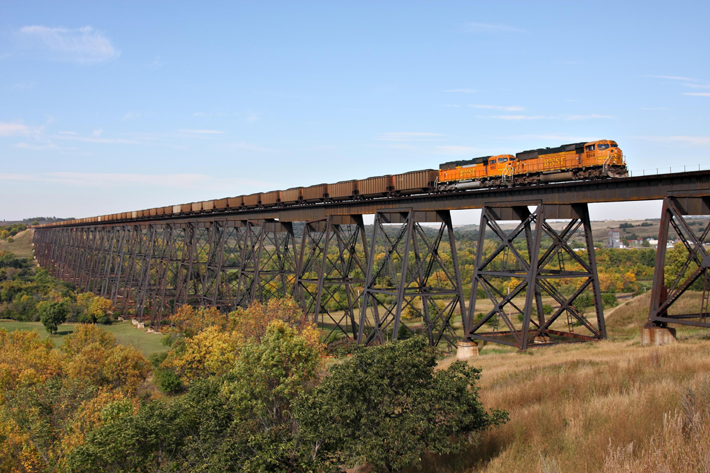
Hi-Line Railroad Bridge
Bridge · 1.3 mi
Historic railroad bridge located over the Sheyenne River in Valley City, North Dakota

Museums and landmarks8

Barnes County Courthouse
Monument and historic site · National Register of Historic Places · 0.4 mi
County courthouse in Valley City, United States of America

Rudolf Hotel
Monument and historic site · National Register of Historic Places
Hotel in Valley City, United States of America
State Normal School at Valley City Historic District
Monument and historic site · National Register of Historic Places
Historic district in North Dakota, United States
U.S. Post Office-Valley City
Monument and historic site · National Register of Historic Places · 0.4 mi
Post office in Valley City, United States of America
Valley City Carnegie Library
Monument and historic site · National Register of Historic Places · 0.4 mi
Public library in Valley City, North Dakota, USA
Valley City Municipal Auditorium
Monument and historic site · National Register of Historic Places
Auditorium in Valley City, United States of America

Parks, trails and playgrounds17


Amphitheater and Fieldstone WPA Features at Valley City Pioneer Park
Park · National Register of Historic Places · 0.6 mi
Place in North Dakota listed as historic place


5 more on the map.
Restaurants and cafes41

Jimmy's Pizza
Restaurant · Pizza
340 E Main Street, Valley City

29 more on the map.
History
Valley City was established in 1874 with the building of a railroad station. The town was originally named Worthington after the town's promoter, George Worthington. The present name is for the city's location in the valley of the Sheyenne River. A post office was established under the name Worthington in 1874, and has continued to operate under the name Valley City since 1878. A Carnegie Library opened in 1903 through the efforts of the "Tuesday Club," a local women's organization. The inception of the nation's first barber association occurred in Valley City during a state barber convention in February, 1909.
From the History section of Valley City, North Dakota on Wikipedia, under CC BY-SA 4.0.
Where to stay7
Churches and places of worship4
All Saints Episcopal Church
Church · National Register of Historic Places · 0.5 mi
Shopping6
Gas and EV charging6
Schools, colleges and libraries7
Healthcare5
Map of Valley City
107 places. The map loads OpenStreetMap tiles when you open it.
Climate by month
Monthly table
| Month | High | Low | Rain |
|---|---|---|---|
| Jan | 18°F | -2°F | 0.5 in |
| Feb | 23°F | 1°F | 0.5 in |
| Mar | 36°F | 14°F | 0.8 in |
| Apr | 53°F | 28°F | 1.2 in |
| May | 67°F | 41°F | 3.2 in |
| Jun | 76°F | 53°F | 3.6 in |
| Jul | 81°F | 57°F | 3.0 in |
| Aug | 80°F | 54°F | 2.6 in |
| Sep | 71°F | 45°F | 2.7 in |
| Oct | 56°F | 32°F | 1.9 in |
| Nov | 38°F | 18°F | 0.7 in |
| Dec | 24°F | 6°F | 0.7 in |
U.S. Climate Normals 1991-2020 for Valley City 3 Nnw (3 mi away), NOAA NCEI.
People and cost of living
American Community Survey 5-year estimates, 2020-2024, U.S. Census Bureau. Estimates have margins of error, larger for small towns.
Disaster history
Barnes County has had 21 federal disaster declarations since 2000, most often for floods.
- 2025-10-22: Severe Storms, Straight-Line Winds, And Tornadoes (Severe Storm)
- 2025-09-11: Severe Storm, Tornadoes, And Straight-Line Winds (Severe Storm)
- 2024-02-15: Severe Winter Storm And Straight-Line Winds (Winter Storm)
- 2023-07-05: Flooding (Flood)
- 2022-07-13: Severe Winter Storm And Flooding (Severe Storm)
- 2020-07-09: Flooding (Flood)
OpenFEMA disaster declarations summaries.
Getting there and nearby towns
Jamestown Regional Airport (JMS) is the nearest airport with scheduled flights listed in OpenStreetMap, 32 miles away.
- Jamestown 33 mi west, about 52 min by car
- Lisbon 37 mi southeast, about 59 min by car
- Casselton 37 mi east, about 1 h by car
- Mayville 51 mi northeast, about 1 h 15 min by car
- West Fargo 52 mi east, about 1 h 30 min by car
- Horace 53 mi east, about 1 h 30 min by car
- Oakes 54 mi south, about 1 h 30 min by car
- Reile's Acres 54 mi east, about 1 h 30 min by car
- Hillsboro 55 mi northeast, about 1 h 30 min by car
- Fargo 56 mi east, about 1 h 30 min by car
Drive times are estimates from straight-line distance, not routes.
Local news
Headlines from INDB, the NEMICO news database.
Reviews, tips and questions
Loading what members have shared...
Sources and licences
- NCES EDGE (Public domain): public schools
- NOAA NCEI U.S. Climate Normals 1991-2020 (Public domain): climate by month
- OpenFEMA (Public domain): disaster declarations
- OpenStreetMap contributors (ODbL 1.0): places, airports, map data
- U.S. Census Bureau (Public domain): population, income, housing, education, commute
- Wikidata (CC0 1.0): elevation, founding date, time zone, website, landmarks and historic places
- Wikimedia Commons (see each image): photos
- Wikipedia (CC BY-SA 4.0): overview and history text
Photo credits
- Greetings from Valley City, North Dakota - Large Letter Postcard (5077621823), Steve Shook from Moscow, Idaho, USA, CC BY 2.0
- Valley City Post Office, Andrew Filer, CC BY-SA 2.0
- Valley City, North Dakota, In memoriam afiler, CC BY-SA 2.0
- Valley City, North Dakota - 6175315496, In memoriam afiler, CC BY-SA 2.0
- Valley City, North Dakota - 6175316344, In memoriam afiler, CC BY-SA 2.0
- Valley City, North Dakota - 6175318182, In memoriam afiler, CC BY-SA 2.0
- Valley City, North Dakota - 6174792079, In memoriam afiler, CC BY-SA 2.0
- Valley City, North Dakota - 6175319742, In memoriam afiler, CC BY-SA 2.0
- Valley City, North Dakota - 6175320446, In memoriam afiler, CC BY-SA 2.0
- Valley City, North Dakota - 6175321434, In memoriam afiler, CC BY-SA 2.0
- Valley City, North Dakota - 6174795391, In memoriam afiler, CC BY-SA 2.0
- Valley City, North Dakota - 6174796233, In memoriam afiler, CC BY-SA 2.0
- Valley City, North Dakota - 6174797223, In memoriam afiler, CC BY-SA 2.0
- Valley City, North Dakota - 6175325534, In memoriam afiler, CC BY-SA 2.0
- Valley City, North Dakota - 6174799461, In memoriam afiler, CC BY-SA 2.0
- Valley City, North Dakota - 6174800427, In memoriam afiler, CC BY-SA 2.0
- Valley City, North Dakota - 6175328034, In memoriam afiler, CC BY-SA 2.0
- Valley City, North Dakota - 6174802073, In memoriam afiler, CC BY-SA 2.0
- Valley City, North Dakota - 6175330042, In memoriam afiler, CC BY-SA 2.0
- Valley City, North Dakota - 6174803983, In memoriam afiler, CC BY-SA 2.0
- Valley City, North Dakota - 6175331962, In memoriam afiler, CC BY-SA 2.0
- Valley City, North Dakota - 6174805711, In memoriam afiler, CC BY-SA 2.0
- Valley City, North Dakota - 6175333826, In memoriam afiler, CC BY-SA 2.0
- Valley City, North Dakota - 6174807927, In memoriam afiler, CC BY-SA 2.0
- Valley City, North Dakota - 6174809035, In memoriam afiler, CC BY-SA 2.0
- Valley City Public Library, Andrew Filer, CC BY-SA 2.0
- Valley City, North Dakota - 6175336958, In memoriam afiler, CC BY-SA 2.0
- Valley City, North Dakota - 6175338018, In memoriam afiler, CC BY-SA 2.0
- Valley City, North Dakota - 6175338986, In memoriam afiler, CC BY-SA 2.0
- Valley City, North Dakota - 6174812731, In memoriam afiler, CC BY-SA 2.0
- Rainbow Arch Bridge, Spanning Sheyenne River at Main Street, East, Valley City (Barnes County, North Dakota), Gary Redmann, photographer, Public domain
- ValleyCityND AllSaintsEpiscopalChurch, Magicpiano, CC BY-SA 4.0
- ValleyCityND PioneerPark Gate, Magicpiano, CC BY-SA 4.0
- Barnes County Courthouse 2009, Andrew Filer, CC BY-SA 2.0
- Bridge at Valley City , North Dakota, chief_huddleston, CC BY 2.0
- ValleyCityND MunicipalAuditorium, Magicpiano, CC BY-SA 4.0
- ValleyCityND WestParkBridge, Magicpiano, CC BY-SA 4.0
- ValleyCityND RudolfHotel, Magicpiano, CC BY-SA 4.0
- ValleyCityND ValleyCityStateU FossHall, Magicpiano, CC BY-SA 4.0
- ValleyCityND ValleyCityStateU Campus3, Magicpiano, CC BY-SA 4.0


Page built October 30, 2026. Spotted a mistake? Tell us or suggest a place.