


Why visit Cái Răng
Townapedia lists 6 museums and landmarks, 1 park or trail, 54 places to eat, 28 places to stay and 2 attractions in and around town.
Highlights include Can Tho Museum.
Weather in Cái Răng
Forecast from MET Norway (CC BY 4.0). Full forecast
About Cái Răng
Cái Răng is a ward in Cần Thơ city, Vietnam. It is one of 103 communes and wards in the city following the 2025 reorganization. The locality has the Cái Răng floating market - a National Intangible Cultural Heritage of Vietnam.
From the Wikipedia article Cái Răng (this version), under CC BY-SA 4.0.
Things to do2

Museums and landmarks6



Parks, trails and playgrounds1

Restaurants and cafes54

Ddok
Restaurant · Korean, Noodles, Regional, Tea · 2.5 km
35 Đường B23
Mo-Sa 08:00-20:40
Quán nhậu bình dân Phố Đêm 35K
Restaurant · 2.0 km
118 Trần Hoàng Na, Cần Thơ
24/7



42 more on the map.
History
Prior to 2025, Cái Răng ward was formerly Ba Láng ward, Hưng Thạnh ward, Lê Bình ward, and Thường Thạnh ward belonging to Cái Răng district, Cần Thơ city.
On June 12, 2025, the National Assembly of Vietnam issued Resolution No. 202/2025/QH15 on the reorganization of provincial-level administrative units. Accordingly:
Cần Thơ city was established by merging the entire area and population of Cần Thơ city, Hậu Giang and Sóc Trăng provinces.
On June 16, 2025, the Standing Committee of the National Assembly of Vietnam issued Resolution No. 1668/NQ-UBTVQH15 on the reorganization of commune-level administrative units in Cần Thơ city. Accordingly:
The Cái Răng ward was established by merging the entire area and population of Ba Láng, Hưng Thạnh, Lê Bình and Thường Thạnh wards (formerly part of Cái Răng district).
From the History section of Cái Răng on Wikipedia, under CC BY-SA 4.0.
Where to stay28
Khách Sạn Tân Vạn Xuân
Motel and hotel · 1.9 km
149 30 Tháng 4, Hưng Lợi, Ninh Kiều, Cần Thơ, Việt Nam
Khách Sạn Thanh Kiều
Motel and hotel · 1.6 km
44 30 THÁNG 4, Hưng Lợi, Ninh Kiều, Cần Thơ, Việt Nam
Churches and places of worship7
Shopping19
Trang sức Titan Cần Thơ - TAJ
Grocery · 2.1 km
Số 52 Đường B31 Khu dân cư 91B, Phường An Khánh
Trung Hoa Kết Nghệ
Shop · 2.0 km
C8-9 Đường số 24, KDC Hoàng Quân, Phường Thường Thạnh
Gas and EV charging10
Schools, colleges and libraries29
Healthcare26
Bệnh viện Y học cổ truyền thành phố Cần Thơ
Hospital · 1.6 km
768 Đường 30 Tháng 4
Nhà thuốc Thúy Linh ( Thuy Linh Drugstore )
Clinic and pharmacy · 2.3 km
Đường 3/2, Cần Thơ
Map of Cái Răng
182 places. The map loads OpenStreetMap tiles when you open it.
Getting there and nearby towns
Can Tho International Airport (VCA) is the nearest airport with scheduled flights listed in OpenStreetMap, 10 km away.
- Cần Thơ 6 km northeast, about 6 min by car
- Bình Thủy 8 km north, about 8 min by car
- Phong Điền 9 km west, about 9 min by car
- Bình Minh 11 km northeast, about 11 min by car
- Thốt Nốt 38 km northwest, about 38 min by car
- Sóc Trăng 51 km southeast, about 51 min by car
- Cao Lãnh 53 km north, about 53 min by car
- Rạch Giá 73 km west, about 1 h 15 min by car
- Bến Tre 73 km east, about 1 h 15 min by car
- Mỹ Tho 78 km northeast, about 1 h 15 min by car
Drive times are estimates from straight-line distance, not routes.
Local news
Headlines from INDB.
Reviews, tips and questions
Loading what members have shared...
Sources and licences
- GeoNames (CC BY 4.0): population, coordinates, regions and time zone
- Mapillary (see each image): photos
- OpenStreetMap contributors (ODbL 1.0): places, airports, map data
- Wikidata (CC0 1.0): elevation, founding date, time zone, website, landmarks and historic places
- Wikimedia Commons (see each image): photos
- Wikipedia (CC BY-SA 4.0): overview and history text
Photo credits
- CHỢ NỔI CÁi Răng, Ninh Kiều, Cần Thơ, Việt Nam - panoramio, trungydang, CC BY 3.0
- Ngô Quyền, Lê Bình, Cái Răng, Cần Thơ, Vietnam - panoramio, trungydang, CC BY 3.0
- Hưng Thạnh, Cái Răng, Cần Thơ, Vietnam - panoramio, trungydang, CC BY 3.0
- Can Tho Museum, Daaé, Public domain
- Cantho University, Kauffner, CC BY-SA 3.0
- Floating market Can Tho (34947), Andre Hospers, CC BY 4.0
- Porridge seller, Can Tho floating market, Dragfyre, CC BY-SA 3.0
- Floating market Can Tho (59989), Andre Hospers, CC BY 4.0
- Cai Rang Floating Market 5, Christophe95, CC BY-SA 4.0
- Cai Rang Floating Market 7, Christophe95, CC BY-SA 4.0
- Cai Rang Floating Market 6, Christophe95, CC BY-SA 4.0
- Cai Rang Floating Market 8, Christophe95, CC BY-SA 4.0
- Floating market Can Tho (36103), Andre Hospers, CC BY 4.0
- Floating market Can Tho (55017), Andre Hospers, CC BY 4.0
- Cai Rang Floating Market 4, Christophe95, CC BY-SA 4.0
- Floating market Can Tho (22246), Andre Hospers, CC BY 4.0
- Floating market Can Tho, Andre Hospers, CC BY 4.0
- Cai Rang Floating Market 2, Christophe95, CC BY-SA 4.0
- Floating market Can Tho (97832), Andre Hospers, CC BY 4.0
- Floating market Can Tho (15362), Andre Hospers, CC BY 4.0
- Floating market Can Tho (46367), Andre Hospers, CC BY 4.0
- Cho An Binh, Ninh kieu, tp, cantho, Vietnam - panoramio, trungydang, CC BY 3.0
- Le marché flottant (Cai Rang, Vietnam) (6642690827), Jean-Pierre Dalbéra from Paris, France, CC BY 2.0
- Le marché flottant (Cai Rang, Vietnam) (6642795155), Jean-Pierre Dalbéra from Paris, France, CC BY 2.0
- Bateaux de croisière individuelle sur le Bassac (Can Tho, Vietnam) (6642687103), Jean-Pierre Dalbéra from Paris, France, CC BY 2.0
- Le marché flottant (Cai Rang, Vietnam) (6642689175), Jean-Pierre Dalbéra from Paris, France, CC BY 2.0
- Le marché flottant (Cai Rang, Vietnam) (6642793923), Jean-Pierre Dalbéra from Paris, France, CC BY 2.0
- Le marché flottant (Cai Rang, Vietnam) (6642699407), Jean-Pierre Dalbéra from Paris, France, CC BY 2.0
- Cai Rang floating market (15724707578), Jean-Marc Astesana from Voisins le Bretonneux, France, CC BY-SA 2.0
- Cai Rang floating market (15886375226), Jean-Marc Astesana from Voisins le Bretonneux, France, CC BY-SA 2.0
- Vietnam license plate 07, Dickelbers, CC BY-SA 4.0
- Bus licenceplate Vietnam, Dickelbers, CC BY-SA 4.0
- Rice noodle factory 4, Christophe95, CC BY-SA 4.0
- Rice noodle factory 5, Christophe95, CC BY-SA 4.0
- Rice noodle factory 1, Christophe95, CC BY-SA 4.0
- Rice noodle factory 2, Christophe95, CC BY-SA 4.0
- Rice noodle factory 3, Christophe95, CC BY-SA 4.0
- Floating Market in Can Tho (Mekong delta) - Flickr - paaddor, Peter Addor from underway, world, CC BY 2.0
- Milefo (Mỹ Khánh, Vietnam) (6642888351), Jean-Pierre Dalbéra from Paris, France, CC BY 2.0
- Fruits du jacquier (Mỹ Khánh, Vietnam) (6642889477), Jean-Pierre Dalbéra from Paris, France, CC BY 2.0
- Cai Rang Floating Market 3, Christophe95, CC BY-SA 4.0
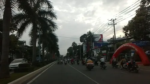
- Street-level photo, hoangvietanh, CC BY-SA 4.0
- Street-level photo, hoangvietanh, CC BY-SA 4.0
- Street-level photo, hoangvietanh, CC BY-SA 4.0


Page built November 8, 2026. Spotted a mistake? Tell us or suggest a place.