


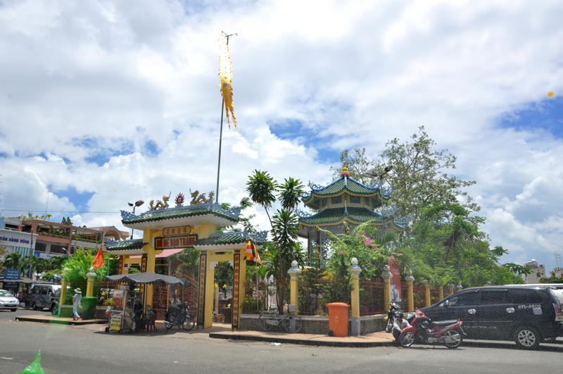


Why visit Châu Đốc
Townapedia lists 5 museums and landmarks, 6 parks and trails, 39 places to eat, 26 places to stay and 1 attraction in and around town.
Highlights include Mount Sam.
Weather in Châu Đốc
Forecast from MET Norway (CC BY 4.0). Full forecast
About Châu Đốc
Châu Đốc is a former city of An Giang Province, bordering Cambodia, in the Mekong Delta region of Vietnam. As of 2019, the city had a population of 101,765, and cover an area of 105.29 square kilometres (40.65 sq mi).
From the Wikipedia article Châu Đốc (city) (this version), under CC BY-SA 4.0.
Travel tips from other travellers: Châu Đốc on Wikivoyage (CC BY-SA 4.0).
Things to do1

Museums and landmarks5

Ngôi Nhà Cổ
Monument and historic site · 1.7 km
Ngôi nhà trong ảnh là nhà sàn truyền thống của người Chăm, thường thấy ở An Giang và khu vực Nam Bộ. Nhà được dựng trên hệ cột cao, giúp...

Parks, trails and playgrounds6


Restaurants and cafes39


Hanuri korean food
Restaurant · Korean · 0.9 km
172 Nguyễn Văn Thoại
Mo-Su 11:00-22:00
Mạnh Tường
Restaurant · Regional · 1.2 km
15 Nguyễn Hữu Cảnh, Châu Đốc
Mo-Su 09:00-21:00

Kim Quang Bakery
Bakery · 1.7 km
ĐT. 953, Tân Châu
Mo-Su 06:00-19:00
Ẩm Thửc Chay
Restaurant · Vietnamese · 1.0 km
68 Đường Trưng Nữ Vương


27 more on the map.
History
The territory became Vietnam's around the 17th century. The town is near the picturesque Sam Mountain where the Sam Mountain Lady (Vietnamese: Bà Chúa Xứ Núi Sam) is worshipped. The Sam Mount Lady Ceremony is held every April of lunar calendar (May) every year.
Floods caused devastation in the region, the one in late 1938 saw 125,000 hectares of ruined rice land due to floods.
On June 16, 2025, the Standing Committee of the National Assembly issued Resolution No. 1685/NQ-UBTVQH15. The city was dissolved and new wards were rearranged from the district.
From the History section of Châu Đốc (city) on Wikipedia, under CC BY-SA 4.0.
Where to stay26
Churches and places of worship50
Chùa Châu Viên
Place of worship · 0.8 km
Hẻm 119 Nguyễn Văn Thoại, Thành phố Châu Đốc
Shopping3
Schools, colleges and libraries15
Healthcare6
Map of Châu Đốc
151 places. The map loads OpenStreetMap tiles when you open it.
Getting there and nearby towns
Rach Gia Airport (VKG) is the nearest airport with scheduled flights listed in OpenStreetMap, 83 km away.
- Châu Phong 3 km northeast, about 3 min by car
- Khánh Hòa 6 km east, about 6 min by car
- Nhà Bàng 15 km southwest, about 15 min by car
- Tân Châu 17 km northeast, about 17 min by car
- Ấp Long Thạnh 18 km east, about 18 min by car
- Tịnh Biên 23 km southwest, about 23 min by car
- Ấp Phú Hòa 22 km north, about 22 min by car
- Cao Lãnh 62 km southeast, about 1 h by car
- Thốt Nốt 66 km southeast, about 1 h by car
- Rạch Giá 77 km south, about 1 h 15 min by car
Drive times are estimates from straight-line distance, not routes.
Local news
Headlines from INDB.
Reviews, tips and questions
Loading what members have shared...
Sources and licences
- GeoNames (CC BY 4.0): population, coordinates, regions and time zone
- Mapillary (see each image): photos
- OpenStreetMap contributors (ODbL 1.0): places, airports, map data
- Wikidata (CC0 1.0): elevation, founding date, time zone, website
- Wikimedia Commons (see each image): photos
- Wikipedia (CC BY-SA 4.0): overview and history text
Photo credits
- Vietnam, Panorama of Chau Doc, Vyacheslav Argenberg, CC BY 4.0
- Thủ Khoa Huân, Châu Phú B, Tp Châu Đốc, An giang, Vietnam - panoramio, trungydang, CC BY 3.0
- Bồ Đề Đạo Tràng, tp Châu đốc, angiang - panoramio, trungydang, CC BY 3.0
- Bồ Đề đạo tràng, châu đốc - panoramio, trungydang, CC BY 3.0
- Le Mont Sam (Vietnam) (6589335173), Jean-Pierre Dalbéra from Paris, France, CC BY 2.0
- Nhà nghỉ trên Núi Sam, thành phố Châu Đốc, Mrdee2103 ( thảo luận ), CC BY-SA 3.0
- Ks Chau Pho, Trung nu vuong, Chau phu B, tp Chau Doc, Angiang-29-10-2013-Dyt - panoramio, trungydang, CC BY 3.0
- Khô cá trê xẻ đôi, Khocatredong, CC BY-SA 4.0
- Nguyen van Thoai, Tp Chau doc, angiang, vietnam - panoramio, trungydang, CC BY 3.0
- Duong Nguyen van thoai, Chau doc ,angiang - panoramio, trungydang, CC BY 3.0
- Duong Thu Khoa Huan, Chua phu B, Tp Chau doc, An giang, vietnam - panoramio, trungydang, CC BY 3.0
- Thu KHoa Huan, Chau phuB, Tp. chau doc, Angiang - panoramio, trungydang, CC BY 3.0
- Chau doc, Chau phu B, Angiang - panoramio, trungydang, CC BY 3.0
- Duong Nguyen Van Thoai, Chau Doc , angiang, vietnam - panoramio, trungydang, CC BY 3.0
- Nguyan Van thoai, Chau Phu B, Chau doc, angiang - panoramio, trungydang, CC BY 3.0
- Trung nu vuong va quang trung, chau phu B, Chaudoc,angiang - panoramio, trungydang, CC BY 3.0
- Nguyen van Thoai va Thu khoa Nghia, tp chaudoc, angiang - panoramio, trungydang, CC BY 3.0
- Truong Mau Giao Hoa HOng, Chau phu B, TpChaudoc, angiang - panoramio, trungydang, CC BY 3.0
- Thu Khoa nghia, Chau Phu A, Chau doc, angiang - panoramio, trungydang, CC BY 3.0
- Nguyen Van thoai, Chau doc angiang - panoramio, trungydang, CC BY 3.0
- Le Bassac à Chau Doc (Vietnam) (6587990029), Jean-Pierre Dalbéra from Paris, France, CC BY 2.0
- Nguyen Huu canh, Chau Phu a, chaudoc, angiang - panoramio, trungydang, CC BY 3.0
- Nguyen Van thoai, Chau phu A, Tp Chau doc, angiang - panoramio, trungydang, CC BY 3.0
- Thu Khoa Nghia, Chau phu A, Chaudoc, angiang - panoramio, trungydang, CC BY 3.0
- Nguyen van thoai, nguyen van vang, Chau pHu A, Chaudoc, angiang - panoramio, trungydang, CC BY 3.0
- Duong Nguyen van thoai, Chau doc angiang - panoramio, trungydang, CC BY 3.0
- Bo De dao trang, Thu khoa nghia, chau Phu A, Chaudoc, angiang - panoramio, trungydang, CC BY 3.0
- Nguyen Huu Canh, Chauphu A, tp Chaudoc, Angiang - panoramio, trungydang, CC BY 3.0
- Dung nguyen van vang, Chau phu A, Chaudoc angiang - panoramio, trungydang, CC BY 3.0
- Duong Chi Lăng, Chau phu A, Tp Chaudoc,angiang - panoramio, trungydang, CC BY 3.0
- Duong Chi Lang, Chau phu A, Tp Chaudoc, angiang - panoramio, trungydang, CC BY 3.0
- Duong pho tp.Chaudoc, Angiang vietnam - panoramio, trungydang, CC BY 3.0
- Nguyen van thoai, Chau doc angiang - panoramio (1), trungydang, CC BY 3.0
- Nguyen Van Vang, Chau Phu A, Tp Chaudoc,Angiang - panoramio, trungydang, CC BY 3.0
- Ng van thoai, chau doc angiang - panoramio, trungydang, CC BY 3.0
- Nguyen van thoai,chau doc angiang vietnam - panoramio, trungydang, CC BY 3.0
- Thu khoa nghia va suong nguyet anh, chau phu A, tp chau doc, angiang - panoramio, trungydang, CC BY 3.0
- Vietnam 08 - 151 - houses over the canals (3186477231), McKay Savage from London, UK, CC BY 2.0
- Vietnam 08 - 169 - riverside homes (3187507614), McKay Savage from London, UK, CC BY 2.0
- Vietnam 08 - 178 - bananas going to market (3186679069), McKay Savage from London, UK, CC BY 2.0
- Street-level photo, VPTD, CC BY-SA 4.0
- Street-level photo, VPTD, CC BY-SA 4.0
- Street-level photo, VPTD, CC BY-SA 4.0
- Street-level photo, VPTD, CC BY-SA 4.0
- Street-level photo, VPTD, CC BY-SA 4.0


Page built November 8, 2026. Spotted a mistake? Tell us or suggest a place.