


Washington, Utah
Washington is a city of 32,348 people in Washington County, Utah, founded in 1857.
Why visit Washington
Townapedia lists 33 museums and landmarks, 46 parks and trails, 180 places to eat, 28 places to stay and 21 attractions in and around town.
Highlights include St. George Opera House, Utah Tech University, Academy Building and Brigham Young Winter Home and Office.
July is the warmest month, with average highs of 102°F; December lows average 28°F.
Weather in Washington
Forecast from the National Weather Service. Full forecast
About Washington
Washington is a city in south central Washington County, Utah, United States and is a part of the St. George Metropolitan Area. The area is also known as Utah's Dixie because the Mormon pioneers who settled the St. George area came to the area to raise cotton, which was milled at the cotton mill in Washington. The population was 27,993 as of 2020. Washington is a fast-growing suburb of St.
From the Wikipedia article Washington, Utah (this version), under CC BY-SA 4.0.
Things to do21

St. George Opera House
Cinema and theater · National Register of Historic Places · 5.3 mi
Opera house

Utah Tech University
School · 5.4 mi
Public university in St. George, Utah, United States

9 more on the map.
Museums and landmarks33

Academy Building
Monument and historic site · National Register of Historic Places · 5.5 mi
Historic building in St. George, Utah, United States

Brigham Young Winter Home and Office
Monument and historic site · National Register of Historic Places · 5.5 mi
Historic house in Utah, United States
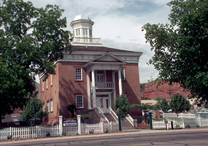
Old Washington County Courthouse
Monument and historic site · National Register of Historic Places · 5.3 mi
Courthouse in St. George, Utah
Robert D. Covington House
Monument and historic site · National Register of Historic Places · 1.1 mi
Washington, UT, listed on the NRHP in Washington
St. George Elementary School
Monument and historic site · National Register of Historic Places · 5.6 mi
Former historic school building in St. George, Utah

Thomas Judd House
Monument and historic site · National Register of Historic Places · 5.5 mi
Historic place in Utah, United States
Washington Cotton Factory
Monument and historic site · National Register of Historic Places · 1.5 mi
Cotton mill in Washington, Utah
Washington Relief Society Hall
Monument and historic site · National Register of Historic Places · 1.6 mi
Historic building in Washington, Utah

Washington School
Museum · National Register of Historic Places · 1.2 mi
Historic school building in Washington, Utah


Woodward School
Monument and historic site · National Register of Historic Places · 5.5 mi
Historic school building in St. George, Utah
Orson Pratt House
Monument and historic site · National Register of Historic Places · 5.4 mi
William F. Butler House
Monument and historic site · National Register of Historic Places · 5.8 mi
21 more on the map.
Parks, trails and playgrounds46


Sand Hollow Resort
Golf course · 4.2 mi
18 hole Par 72 Championship Course & 9 hole Par 36 Links Course & 9 hole Pitch & Putt Wee Course
5625 West Clubhouse Drive, Hurricane
Town Square
Park · 5.5 mi
A historic city block and park in St. George, Utah


34 more on the map.
Restaurants and cafes180


Bangkok Thai Express
Restaurant · Thai · 1.9 mi
969 North 3050 East, Saint George
Tu-Su 11:30-15:00,16:30-21:00; Mo off
Cafe Rio
Restaurant · Mexican · 3.9 mi
15 S River Rd, Saint George
Mo-We 10:30-22:00, Th-Sa 10:30-23:00, Su 10:30-22:00
Crepe Station European Bistro
Restaurant · French, Coffee, Crepe, Tea · 1.7 mi
520 West Telegraph Street, Washington
Mo-Sa 08:00-16:00
Golden Corral
Restaurant · American, Buffet · 3.9 mi
River Road, St. George
Mo-Sa 11:00-21:00; Su 11:00-20:00
Korea Picnic
Restaurant · Korean · 1.7 mi
568 West Telegraph Street, Washington
Mo-Th 11:00-15:00,16:30-20:00; Fr-Sa 11:00-20:00; Su off
Meráki Greek Grill
Restaurant · Greek · 4.1 mi
473 S River Rd, Saint George
Su-Th 11:00-21:00; Fr-Sa 11:00-22:00
Red Fort Cuisine of India
Restaurant · Indian · 3.9 mi
148 South 1470 East, Saint George
Su-Th 11:00-14:30,16:30-21:30; Fr-Sa 11:00-14:30,16:30-22:00
Spitz
Restaurant · Mediterranean, Turkish · 4.7 mi
1543 S River Road, Saint George
Mo-Sa 11:00-21:00; Su 11:30-19:00

168 more on the map.
History
The Church of Jesus Christ of Latter-Day Saints sent a group of 28 families to the area to attempt to grow cotton. The "cotton mission" was led by former Mississippi cotton plantation owner Robert Dockery Covington, along with some of the early settlers from the southeastern United States. The area was nicknamed Utah's Dixie; Dixie was a nickname for the southeastern states.
From the History section of Washington, Utah on Wikipedia, under CC BY-SA 4.0.
Where to stay28
Churches and places of worship27
St. George Tabernacle
Church · National Register of Historic Places · 5.4 mi
St. George Utah Temple
Church · National Register of Historic Places · 5.3 mi
The Church of Jesus Christ of Latter-day Saints
Church · Mormon · 2.5 mi
595 North 2450 East
The Church of Jesus Christ of Latter-day Saints
Church · Mormon · 3.0 mi
441 South 2200 East, St. George
Shopping41
Gas and EV charging30
Schools, colleges and libraries57
Healthcare12
Fortify Physical Therapy
Clinic and pharmacy · 3.0 mi
792 South 3000 East, Saint George
Map of Washington
250 places. The map loads OpenStreetMap tiles when you open it.
Climate by month
Monthly table
| Month | High | Low | Rain | Snow |
|---|---|---|---|---|
| Jan | 54°F | 28°F | 1.2 in | 0.5 in |
| Feb | 59°F | 32°F | 1.4 in | 0.5 in |
| Mar | 68°F | 39°F | 1.0 in | 0.2 in |
| Apr | 75°F | 46°F | 0.7 in | 0.0 in |
| May | 85°F | 56°F | 0.3 in | 0.0 in |
| Jun | 96°F | 64°F | 0.2 in | 0.0 in |
| Jul | 102°F | 72°F | 0.5 in | 0.0 in |
| Aug | 100°F | 70°F | 1.1 in | 0.0 in |
| Sep | 92°F | 61°F | 0.7 in | 0.0 in |
| Oct | 79°F | 47°F | 0.8 in | 0.0 in |
| Nov | 64°F | 35°F | 0.7 in | 0.0 in |
| Dec | 53°F | 28°F | 0.9 in | 0.0 in |
U.S. Climate Normals 1991-2020 for St George Hcn (7 mi away), NOAA NCEI.
People and cost of living
American Community Survey 5-year estimates, 2020-2024, U.S. Census Bureau. Estimates have margins of error, larger for small towns.
Disaster history
Washington County has had 12 federal disaster declarations since 2000, most often for fires.
- 2025-06-20: Forsyth Fire (Fire)
- 2020-07-13: Veyo West Fire (Fire)
- 2020-04-04: Covid-19 Pandemic (Biological)
- 2020-03-13: Covid-19 (Biological)
- 2016-06-21: Saddle Fire (Fire)
- 2012-11-03: Severe Storm And Flooding (Flood)
OpenFEMA disaster declarations summaries.
Getting there and nearby towns
St. George Regional Airport (SGU) is the nearest airport with scheduled flights listed in OpenStreetMap, 6 miles away.
- St. George 6 mi southwest, about 10 min by car
- Hurricane 7 mi east, about 12 min by car
- Santa Clara 9 mi west, about 15 min by car
- Ivins 11 mi west, about 18 min by car
- Leeds 11 mi northeast, about 18 min by car
- Toquerville 14 mi northeast, about 23 min by car
- La Verkin 15 mi northeast, about 24 min by car
- Dammeron Valley 16 mi northwest, about 25 min by car
- Mesquite 41 mi southwest, about 1 h by car
- Cedar City 44 mi northeast, about 1 h 15 min by car
Drive times are estimates from straight-line distance, not routes.
Local news
Headlines from INDB, the NEMICO news database.
Reviews, tips and questions
Loading what members have shared...
Sources and licences
- NCES EDGE (Public domain): public schools
- NOAA NCEI U.S. Climate Normals 1991-2020 (Public domain): climate by month
- OpenFEMA (Public domain): disaster declarations
- OpenStreetMap contributors (ODbL 1.0): places, airports, map data
- U.S. Census Bureau (Public domain): population, income, housing, education, commute
- Wikidata (CC0 1.0): elevation, founding date, time zone, website, landmarks and historic places
- Wikimedia Commons (see each image): photos
- Wikipedia (CC BY-SA 4.0): overview and history text
Photo credits
- Washington, Utah, Raymond Shobe, CC BY 2.0
- Washington Utah City Museum, Ntsimp, CC0
- Washington School building - Washington City, Utah - 3 May 2015, Beneathtimp, CC0
- Monument Plaza - Washington School building, Washington City, Utah - 3 May 2015, Beneathtimp, CC0
- Washington Utah Relief Society Hall, Ntsimp, CC0
- Washington Cotton Factory, Delos H. Smith, Public domain
- Washington, Utah looking West on Red Cliff Drive (7054477537), 5of7, CC BY-SA 2.0
- Washington, Utah looking West on Red Cliff Drive (7054477541), 5of7, CC BY-SA 2.0
- THOMAS JUDD HOUSE, ST. GEORGE, WASHINGTON COUNTY, UTAH, JERRYE & ROY KLOTZ, M.D., CC BY-SA 4.0
- Artsbldgstgeout, Manway at en.wikipedia, CC BY-SA 3.0
- St. George Tabernacle, P. Kent Fairbanks, Public domain
- St. George Temple, Unknown author, CC BY-SA 2.5
- Old Washington County Courthouse in color, Calvin Beale, Public domain
- Woodward school, Kneumann78, CC BY-SA 4.0
- Cochemiea tetrancistra 14, colorful-corvid, CC BY 4.0
- Cochemiea tetrancistra 13, colorful-corvid, CC BY 4.0
- Cochemiea tetrancistra 15, colorful-corvid, CC BY 4.0
- Cochemiea tetrancistra 16, colorful-corvid, CC BY 4.0
- Robert D. Covington House, Delos H. Smith, Public domain
- St. George - panoramio, hakkun, CC BY-SA 3.0
- Southerly View - panoramio (1), Kurt Minard, CC BY-SA 3.0
- Echinocereus relictus 17, Tait Sougstad, CC0
- ISS053-E-61287 - View of Earth, Earth Science and Remote Sensing Unit , Lyndon B. Johnson Space Center, Public domain
- ISS053-E-175820 - View of Earth, Earth Science and Remote Sensing Unit , Lyndon B. Johnson Space Center, Public domain
- ISS053-E-197093 - View of Earth, Earth Science and Remote Sensing Unit , Lyndon B. Johnson Space Center, Public domain
- ISS065-E-319714 - View of Earth, Earth Science and Remote Sensing Unit , Lyndon B. Johnson Space Center, Public domain
- ISS053-E-175819 - View of Earth, Earth Science and Remote Sensing Unit , Lyndon B. Johnson Space Center, Public domain
- ISS065-E-319713 - View of Earth, Earth Science and Remote Sensing Unit , Lyndon B. Johnson Space Center, Public domain
- ISS053-E-197092 - View of Earth, Earth Science and Remote Sensing Unit , Lyndon B. Johnson Space Center, Public domain
- ISS065-E-319711 - View of Earth, Earth Science and Remote Sensing Unit , Lyndon B. Johnson Space Center, Public domain
- ISS038-E-1364 - View of Earth, Earth Science and Remote Sensing Unit , Lyndon B. Johnson Space Center, Public domain
- ISS065-E-319712 - View of Earth, Earth Science and Remote Sensing Unit , Lyndon B. Johnson Space Center, Public domain
- Begin (Again) UT-7 East - panoramio, Rover_0, CC BY 3.0
- 1500Efferia basini DSC3118 DxO, Pdeley, CC BY-SA 4.0
- Echinocereus relictus 16, Tait Sougstad, CC0
- EpicautaWheeleri, EpicAstro, CC BY-SA 4.0
- Pine Valley Mountain (laccolith) and a small cinder cone. Near the boundary of the Navajo Sandstone (Jn) and Kayenta (Jk) Formation (both Jurassic) - panoramio, Steve Montgomery, CC BY-SA 3.0
- Surface baked sandstone, presumably contact metamorphosis from a basalt flow. Still need to look at the nearby basalt flow for more examples of this. - panoramio, Steve Montgomery, CC BY-SA 3.0
- 1500Efferia basini DSC3136 DxO, Pdeley, CC BY-SA 4.0
- Black Hairy Scorpion (Hadrurus spadix), Marshal Hedin, CC BY 2.0


Page built October 30, 2026. Spotted a mistake? Tell us or suggest a place.