


Waterloo, New York
Waterloo is a village of 4,605 people in Seneca County, New York, founded in April 9, 1824.
Why visit Waterloo
Townapedia lists 13 museums and landmarks, 10 parks and trails, 11 places to eat and 3 places to stay in and around town.
Highlights include Hunt House, M'Clintock House, Lafayette Park and Luce's Park.
July is the warmest month, with average highs of 79°F; January lows average 16°F, and about 57 inches of snow fall in a normal year.
Weather in Waterloo
Forecast from the National Weather Service. Full forecast
About Waterloo
Waterloo is a village and primary county seat of Seneca County, New York, United States. The population was 5,171 at the 2010 census and is now the most populated village in Seneca County. The village is named after Waterloo, Belgium, where Napoleon was defeated. It is the primary county seat of Seneca County, with the other being Ovid as part of a two-shire system established in 1822.
From the Wikipedia article Waterloo (village), New York (this version), under CC BY-SA 4.0.
Museums and landmarks13
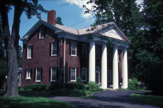
Hunt House
Monument and historic site · National Register of Historic Places · 0.7 mi
Historic house in Waterloo, New York, United States
3230 State Route 89, Savannah

M'Clintock House
Monument and historic site · National Register of Historic Places
Historic house in New York, United States
14 East Williams Street, Waterloo

Waterloo Library
Monument and historic site · National Register of Historic Places
Library in Waterloo, New York
31 East Williams Street, Waterloo

Amelia Bloomer House
Monument and historic site · National Register of Historic Places · 3.5 mi
Historic home in Seneca Falls, New York

James Russell Webster House
Monument and historic site · National Register of Historic Places
Historic house in New York, United States
United States Post Office
Monument and historic site · National Register of Historic Places
Government building in Waterloo, New York

United States Post Office
Monument and historic site · National Register of Historic Places · 3.1 mi
Government building in Seneca Falls, New York
William H. Burton House
Monument and historic site · National Register of Historic Places
Historic house in New York, United States

Women's Rights National Historical Park
Monument and historic site · National Register of Historic Places · 2.9 mi
Historic park and museum in New York state, USA



LaFayette Apartments
Monument and historic site · 0.4 mi
206 West Main Street, Waterloo
1 more on the map.
Parks, trails and playgrounds10

Luce's Park
Park · 0.7 mi
Sign in Waste Water Treatment Plan indicates hours.
East River Street, Waterloo
24/7


Restaurants and cafes11


F-n-A Rhythm and Booze
Restaurant · Pizza, Wings
5 South Virginia Street, Waterloo
Mo-Sa 08:00-22:00, Su 10:00-22:00
La Fiesta Brava
Restaurant · Mexican
9 East Main Street, Waterloo
Su 11:00-20:00, Mo-Th 11:00-21:00, Fr-Sa 11:00-22:00


Where to stay3

Microtel Inn & Suites by Wyndham Seneca Falls
Motel and hotel · 1.3 mi
1966 Route 5 and 20, Seneca Falls
History
The area was within the realm of the Cayuga nation, one of several bands to form the Iroquois League. The current site of the village was the location of the former Cayuga village "Skoiyase" (or Skoi-Yase), meaning "flowing water", which was established around 1500. They were visited by Jesuit missionaries in the 17th century. After the Sullivan Expedition of 1779 destroyed Skoiyase, many natives left the area. The land then became part of the Central New York Military Tract, reserved for veterans.
The first new settler, Jabez Gorham, arrived on the site of the village around 1795. The early village was known as "New Hudson". It was also known as "Scoys", based on the name of the former Native American village.
From the History section of Waterloo (village), New York on Wikipedia, under CC BY-SA 4.0.
Churches and places of worship8
First Presbyterian Church
Church · Presbyterian · National Register of Historic Places
42 East Main Street, Waterloo
United Methodist Church
Church · National Register of Historic Places
Shopping6
Gas and EV charging1
Schools, colleges and libraries11
Elizabeth Cady Stanton Elementary School
School · 3.3 mi
38 Garden St, Seneca Falls
Healthcare3
Map of Waterloo
66 places. The map loads OpenStreetMap tiles when you open it.
Climate by month
Monthly table
| Month | High | Low | Rain | Snow |
|---|---|---|---|---|
| Jan | 30°F | 16°F | 1.8 in | 13.5 in |
| Feb | 32°F | 17°F | 1.6 in | 13.3 in |
| Mar | 40°F | 24°F | 2.4 in | 12.8 in |
| Apr | 54°F | 35°F | 2.8 in | 1.8 in |
| May | 67°F | 46°F | 3.3 in | 0.0 in |
| Jun | 75°F | 56°F | 3.6 in | 0.0 in |
| Jul | 79°F | 61°F | 3.7 in | 0.0 in |
| Aug | 78°F | 59°F | 3.5 in | 0.0 in |
| Sep | 71°F | 52°F | 3.3 in | 0.0 in |
| Oct | 58°F | 41°F | 3.8 in | 0.1 in |
| Nov | 46°F | 32°F | 2.5 in | 4.7 in |
| Dec | 36°F | 23°F | 2.3 in | 10.4 in |
U.S. Climate Normals 1991-2020 for Geneva Rsch Farm Hcn (9 mi away), NOAA NCEI.
People and cost of living
American Community Survey 5-year estimates, 2020-2024, U.S. Census Bureau. Estimates have margins of error, larger for small towns.
Disaster history
Seneca County has had 10 federal disaster declarations since 2000, most often for biologicals.
- 2020-03-20: Covid-19 Pandemic (Biological)
- 2020-03-13: Covid-19 (Biological)
- 2018-10-01: Severe Storms And Flooding (Flood)
- 2012-10-28: Hurricane Sandy (Hurricane)
- 2005-09-30: Hurricane Katrina Evacuation (Hurricane)
- 2004-08-03: Severe Storms And Flooding (Severe Storm)
OpenFEMA disaster declarations summaries.
Getting there and nearby towns
Ithaca Tompkins International Airport (ITH) is the nearest airport with scheduled flights listed in OpenStreetMap, 35 miles away.
- Seneca Falls 3 mi east, about 5 min by car
- Geneva 7 mi southwest, about 11 min by car
- Union Springs 10 mi southeast, about 15 min by car
- Phelps 11 mi west, about 18 min by car
- Clyde 12 mi north, about 20 min by car
- Lyons 13 mi northwest, about 21 min by car
- Clifton Springs 14 mi west, about 23 min by car
- Auburn 15 mi east, about 24 min by car
- Newark 15 mi northwest, about 24 min by car
- Melrose Park 17 mi east, about 28 min by car
Drive times are estimates from straight-line distance, not routes.
Local news
Headlines from INDB, the NEMICO news database.
Reviews, tips and questions
Loading what members have shared...
Sources and licences
- NCES EDGE (Public domain): public schools
- NOAA NCEI U.S. Climate Normals 1991-2020 (Public domain): climate by month
- OpenFEMA (Public domain): disaster declarations
- OpenStreetMap contributors (ODbL 1.0): places, airports, map data
- U.S. Census Bureau (Public domain): population, income, housing, education, commute
- Wikidata (CC0 1.0): elevation, founding date, time zone, website, landmarks and historic places
- Wikimedia Commons (see each image): photos
- Wikipedia (CC BY-SA 4.0): overview and history text
Photo credits
- Waterloo Library Aug 09, Doug Kerr from now in Binghamton, NY, CC BY-SA 2.0
- First Presbyterian Church Waterloo NY, Kenneth C. Zirkel, CC BY-SA 3.0
- William H. Burton House Waterloo NY, Kenneth C. Zirkel, CC BY-SA 3.0
- WaterlooNY JamesRussellWebsterHouse, Magicpiano, CC BY-SA 4.0
- WaterlooNY MClintockHouse, Magicpiano, CC BY-SA 4.0
- WaterlooNY MClintockHouse (cropped), Magicpiano, CC BY-SA 4.0
- United States Post Office Waterloo, New York entrance 2013, Kenneth C. Zirkel, CC BY-SA 3.0
- United States Post Office Waterloo, New York front view 2013, Kenneth C. Zirkel, CC BY-SA 3.0
- WaterlooNY Downtown 1, Magicpiano, CC BY-SA 4.0
- WaterlooNY Downtown 2, Magicpiano, CC BY-SA 4.0
- Burton House Waterloo Aug 09, Doug Kerr from now in Binghamton, NY, CC BY-SA 2.0
- First Presbyterian Church Waterloo Aug 09, Doug Kerr from now in Binghamton, NY, CC BY-SA 2.0
- St Pauls Church Waterloo Aug 09, Doug Kerr from now in Binghamton, NY, CC BY-SA 2.0
- United Methodist Church Waterloo Aug 09, Doug Kerr from now in Binghamton, NY, CC BY-SA 2.0
- Stream between Waterloo and Fayette, Seneca County, New York 01, Photo by Joe Mabel, CC BY-SA 4.0
- Bridge from Waterloo to Fayette, Seneca County, New York 01, Photo by Joe Mabel, CC BY-SA 4.0
- Fayette, New York - Waterloo Hydroelectric Project powerhouse 01, Photo by Joe Mabel, CC BY-SA 4.0
- Fayette, New York - Waterloo Hydroelectric Project powerhouse 02, Photo by Joe Mabel, CC BY-SA 4.0
- NYSEG Substation Waterloo 01, Photo by Joe Mabel, CC BY-SA 4.0
- Veterans' monument and replica cannons at Lafayette Park, Waterloo, New York - 20210710, Andre Carrotflower, CC BY-SA 4.0
- High School Centennial Arch and Skoi-yase Monument at Lafayette Park, Waterloo, New York - 20210710 - 01, Andre Carrotflower, CC BY-SA 4.0
- High School Centennial Arch and Skoi-yase Monument at Lafayette Park, Waterloo, New York - 20210710 - 02, Andre Carrotflower, CC BY-SA 4.0
- HUNT HOUSE, JERRYE & ROY KLOTZ MD, CC BY-SA 3.0
- JANE HUNT HOUSE, JERRYE & ROY KLOTZ MD, CC BY-SA 3.0
- Amelia Bloomer House Seneca Falls NY, Kenneth C. Zirkel, CC BY-SA 3.0
- James Russell Webster House ca. 1877, James Russel Webster, Public domain
- WesleyanChapel, National Park Service, Public domain
- US Post Office-Seneca Falls NY Aug 09, Doug Kerr from now in Binghamton, NY, CC BY-SA 2.0
- Fayette, New York - Locust Street Bridge over the Seneca River 01, Photo by Joe Mabel, CC BY-SA 4.0
- Fayette, New York - Locust Street Bridge over the Seneca River 02, Photo by Joe Mabel, CC BY-SA 4.0
- Calvary Lutheran Church, Seneca Falls, New York - 20220707, Andre Carrotflower, CC BY-SA 4.0
- The Eagle is Landing - panoramio, Art Anderson, CC BY-SA 3.0
- Cayuga-Seneca Canal Trail view, Staib, CC BY 4.0
- Cayuga-Seneca Canal Trail path, Staib, CC BY 4.0


Page built October 30, 2026. Spotted a mistake? Tell us or suggest a place.