
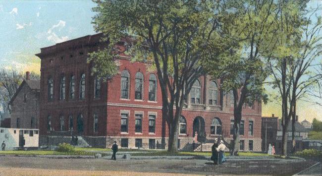


Why visit Waterville
Townapedia lists 39 museums and landmarks, 35 parks and trails, 76 places to eat, 9 places to stay and 10 attractions in and around town.
Highlights include Main Film Center, Two Cent Bridge, Colby College Museum of Art and Brick School.
July is the warmest month, with average highs of 80°F; January lows average 9°F.
Weather in Waterville
Forecast from the National Weather Service. Full forecast
About Waterville
Waterville is a city in Kennebec County, Maine, United States, on the west bank of the Kennebec River. A college town, the city is home to Colby College, a NESCAC college, and Thomas College. Colby College and Waterville also serve as the host of the prestigious Summer Science Program.
From the Wikipedia article Waterville, Maine (this version), under CC BY-SA 4.0.
Things to do10


Two Cent Bridge
Bridge · National Register of Historic Places · 1.8 mi
Suspension bridge in Maine, U.S.
Waterville Opera House
Cinema and theater · 1.6 mi
1 Common Street, Waterville


Museums and landmarks39

Colby College Museum of Art
Museum · 1.4 mi
Art museum specializing in American and contemporary art
5600 Mayflower Hill Drive, Waterville
Mo off; Tu-We 10:00-17:00; Th 10:00-21:00; Fr-Sa 10:00-17:00; Su...

Brick School
Monument and historic site · National Register of Historic Places · 2.9 mi
Historic one-room schoolhouse on Cushman Road in Winslow, Maine
328 Cushman Road, Waterville

Fort Halifax
Monument and historic site · National Register of Historic Places · 1.6 mi
Fort in Maine

Redington Museum
Museum · National Register of Historic Places · 1.3 mi
Historic house in Maine, United States

Alvin O. Lombard House
Monument and historic site · National Register of Historic Places · 1.5 mi
Historic house in Waterville, Maine

Amos Gerald House
Monument and historic site · National Register of Historic Places · 4.1 mi
Historic house in Maine, United States

Benton Grange No. 458
Monument and historic site · National Register of Historic Places · 4.8 mi
Building in Maine, United States of America

Connor-Bovie House
Monument and historic site · National Register of Historic Places · 4.2 mi
Historic house in Maine, United States

Cotton-Smith House
Monument and historic site · National Register of Historic Places · 4.1 mi
Fairfield, Maine, listed on the NRHP in Somerset County, Maine
Foster-Redington House
Monument and historic site · National Register of Historic Places · 1.4 mi
Historic house at 8 Park Place in Waterville, Maine
Heald House
Monument and historic site · National Register of Historic Places · 1.3 mi
Historic house in Maine, United States
Jonas R. Shurtleff House
Monument and historic site · National Register of Historic Places · 1.6 mi
House in Winslow, Maine
27 more on the map.
Parks, trails and playgrounds35





23 more on the map.
Restaurants and cafes76

The Ice Cream Shoppe of Oakland
Ice cream · 1.6 mi
902 Kennedy Memorial Drive, Oakland
Sep-May Mo-Su 12:00-20:00; Jun-Aug Mo-Su 12:00-21:00


Grand Central Cafe
Restaurant · Pizza · 1.7 mi
10 Railroad Square, Waterville
Mo-We 17:00-20:00; Th 11:00-20:00; Fr-Sa 11:00-21:00
Mirakuya Sushi & Steak House
Restaurant · Sushi, Steak House · 0.6 mi
150 Jfk Plaza, Waterville
Mo-Th 11:00-14:30, 16:00-21:30, Fr-Sa 11:00-14:30, 16:00-22:00, Su...
Rita’s House of Pizza
Restaurant · American, Pizza · 1.7 mi
51 Bay Street, Waterville
Mo-We 11:00-20:00; Th-Sa 11:00-21:00; Su 16:00-20:00
Selah Tea Cafe
Cafe · Breakfast, Brunch · 1.6 mi
177 Main Street, Waterville
Mo-Fr 07:00-17:00; Sa-Su 08:00-17:00
Starbucks
Cafe · Coffee Shop · 2.0 mi
2 Waterville Commons Drive, Waterville
Mo-Sa 05:00-20:00; Su 06:00-20:00
The Two Cent Pub
Restaurant · Pasta, Pizza, Sandwich · 2.1 mi
82 Clinton Avenue, Waterville
Mo-Th 08:00-21:00; Fr-Sa 08:00-22:00; Su 10:00-21:00
64 more on the map.
History
The area now known as Waterville was once inhabited by the Canibas tribe of the Abenaki people. Called "Taconnet" after Chief Taconnet, the main village was located on the east bank of the Kennebec River at its confluence with the Sebasticook River at what is now Winslow. Known as "Ticonic" by English settlers, it was burned in 1692 during King William's War, after which the Canibas tribe abandoned the area. Fort Halifax was built by General John Winslow in 1754, and the last skirmish with indigenous peoples occurred on May 18, 1757.
The township would be organized as Kingfield Plantation, then incorporated as Winslow in 1771. In 1776 because Maine was part of Massachusetts during the Revolution, copies of the United States Declaration of Independence were sent to local assemblies to be read aloud to citizens. Historical gatherings took place in civic centers like the Harpswell Meetinghouse and at Hallowell City Hall. When residents on the west side of the Kennebec found themselves unable to cross the river to attend town meetings, Waterville was founded from the western parts of Winslow and incorporated on June 23, 1802. In 1824 a bridge was built joining the communities. Early industries included fishing, lumbering, agriculture and ship building, with larger boats launched in spring during freshets. By the early 1900s, there were five shipyards in the community.
From the History section of Waterville, Maine on Wikipedia, under CC BY-SA 4.0.
Where to stay9
Best Western Plus Waterville Grand Hotel
Motel and hotel · 2.1 mi
375 Main Street, Waterville
Budget Host - Airport Inn
Motel and hotel · 0.6 mi
400 Kennedy Memorial Drive, Waterville
Churches and places of worship17
First Baptist Church
Church · Nondenominational · National Register of Historic Places · 1.5 mi
1 Park Street, Waterville
Asa Bates Memorial Chapel
Church · National Register of Historic Places · 3.6 mi
Universalist-Unitarian Church
Church · National Register of Historic Places · 1.3 mi
The Church of Jesus Christ of Latter-day Saints
Church · Mormon · 0.8 mi
26 Washington Street, Waterville
Notre Dame du Perpetuel Secours Catholic Church
Church · Roman Catholic · 1.0 mi
116 Silver Street, Waterville
Saint John the Baptist Catholic Church
Church · Roman Catholic · 1.9 mi
26 Monument Street, Winslow
Blood Bought Church
Church · Pentecostal · 1.5 mi
866 Kennedy Memorial Drive, Oakland
First Congregational Church
Church · United · 1.7 mi
7 Eustis Parkway, Waterville
Shopping25
Gas and EV charging10
Schools, colleges and libraries25
Messalonskee High School
School · 2.7 mi
131 Messalonskee High Drive, Oakland
Waterville Senior High School
School · 0.9 mi
1 Brooklyn Avenue, Waterville
Mount Merici Academy
School · Catholic · 0.6 mi
18 Mount Merci Avenue, Waterville
Healthcare11
Kennebec Behavioral Health - Waterville Clinic
Clinic and pharmacy · 1.5 mi
67 Eustis Parkway, Waterville
MaineGeneral Express Care
Clinic and pharmacy · 1.6 mi
211 Main Street, Waterville
Map of Waterville
250 places. The map loads OpenStreetMap tiles when you open it.
Climate by month
Monthly table
| Month | High | Low | Rain |
|---|---|---|---|
| Jan | 28°F | 9°F | 3.1 in |
| Feb | 32°F | 10°F | 2.6 in |
| Mar | 40°F | 20°F | 3.3 in |
| Apr | 54°F | 32°F | 3.7 in |
| May | 66°F | 43°F | 3.3 in |
| Jun | 75°F | 53°F | 4.0 in |
| Jul | 80°F | 59°F | 3.4 in |
| Aug | 80°F | 57°F | 3.4 in |
| Sep | 72°F | 50°F | 3.8 in |
| Oct | 59°F | 38°F | 4.9 in |
| Nov | 46°F | 29°F | 3.9 in |
| Dec | 34°F | 17°F | 3.9 in |
U.S. Climate Normals 1991-2020 for Waterville Trtmt Plt (1 mi away), NOAA NCEI.
People and cost of living
American Community Survey 5-year estimates, 2020-2024, U.S. Census Bureau. Estimates have margins of error, larger for small towns.
Disaster history
Kennebec County has had 15 federal disaster declarations since 2000, most often for severe storms.
- 2024-01-30: Severe Storm And Flooding (Severe Storm)
- 2023-09-14: Hurricane Lee (Hurricane)
- 2023-07-06: Severe Storm And Flooding (Flood)
- 2020-04-04: Covid-19 Pandemic (Biological)
- 2020-03-13: Covid-19 (Biological)
- 2018-01-02: Severe Storm And Flooding (Severe Storm)
OpenFEMA disaster declarations summaries.
Getting there and nearby towns
Waterville Robert LaFleur Airport (WVL) is the nearest airport with scheduled flights listed in OpenStreetMap, 1 miles away.
- Oakland 2 mi west, about 4 min by car
- Winslow 3 mi east, about 4 min by car
- Fairfield 4 mi northeast, about 7 min by car
- Clinton 11 mi northeast, about 18 min by car
- Augusta 15 mi south, about 24 min by car
- Lewiston 40 mi southwest, about 1 h by car
- Auburn 43 mi southwest, about 1 h 15 min by car
- Bangor 47 mi northeast, about 1 h 15 min by car
- Brunswick 48 mi south, about 1 h 15 min by car
- Orono 53 mi northeast, about 1 h 30 min by car
Drive times are estimates from straight-line distance, not routes.
Local news
Headlines from INDB, the NEMICO news database.
Reviews, tips and questions
Loading what members have shared...
Sources and licences
- NCES EDGE (Public domain): public schools
- NOAA NCEI U.S. Climate Normals 1991-2020 (Public domain): climate by month
- OpenFEMA (Public domain): disaster declarations
- OpenStreetMap contributors (ODbL 1.0): places, airports, map data
- U.S. Census Bureau (Public domain): population, income, housing, education, commute
- Wikidata (CC0 1.0): elevation, founding date, time zone, website, landmarks and historic places
- Wikimedia Commons (see each image): photos
- Wikipedia (CC BY-SA 4.0): overview and history text
Photo credits
- City Hall & Opera House, Waterville, ME, George Gilman Adams, Public domain
- WatervilleME ElizabethAnnSetonHospital, Magicpiano, CC BY-SA 4.0
- WatervilleME MtMericiHD, Magicpiano, CC BY-SA 4.0
- WatervilleME UUChurch, Magicpiano, CC BY-SA 4.0
- WatervilleME RedingtonHouse, Magicpiano, CC BY-SA 4.0
- Heald House (Waterville, Maine), Jim Roberts, CC BY-SA 4.0
- Old Waterville High School, Jim Roberts, CC BY-SA 4.0
- Breeding pair of Yellow Warblers (Setophaga aestiva) in Waterville, Maine, Jshamgochian, CC BY-SA 4.0
- WatervilleME FirstBaptistChurch, Magicpiano, CC BY-SA 4.0
- Colby College Museum of Art, Colby Mariam, CC BY-SA 4.0
- WinslowME BrickSchool2, Magicpiano, CC BY-SA 4.0
- Fort Halifax, Winslow, ME, Unknown photographer, Public domain
- TwocentbridgeME, DanielEng at English Wikipedia, CC BY 2.5
- Memorial Hall, Oakland, ME, Unknown photographer, Public domain
- FairfieldME LawrenceLibrary, Magicpiano, CC BY-SA 4.0
- BentonME GrangeHall, Magicpiano, CC BY-SA 4.0
- FairfieldME CottonSmithHouse, Magicpiano, CC BY-SA 4.0
- CONNOR-BOVIE HOUSE, JERRYE & ROY KLOTZ MD, CC BY-SA 3.0
- Waterville, ME City Hall (2014) IMG 2652, Billy Hathorn, CC BY-SA 3.0
- One Post Office Square in Waterville, ME IMG 2630, Billy Hathorn, CC BY-SA 3.0
- AMOS GEROLD HOUSE, JERRYE & ROY KLOTZ MD, CC BY-SA 3.0
- VassalboroME WilliamFGrantHouse, Magicpiano, CC BY-SA 4.0
- VassalboroME MillAgentsHouse, Magicpiano, CC BY-SA 4.0
- Bridge & Lockwood Mills, Waterville, ME, Unknown author, Public domain
- OaklandME PresseyHouse, Magicpiano, CC BY-SA 4.0
- Professional Building (Waterville, Maine), Jim Roberts, CC BY-SA 4.0
- Oakland Public Library, Oakland, ME, Unknown photographer, Public domain
- FairfieldME AsaBatesMemorialChapel, Magicpiano, CC BY-SA 4.0
- Colby College Mary Low Coburn, Unknown author, CC0
- Colby College Foss Woodman Hall, Unknown author, CC0
- Gordon Center building, Communications and Engagement, CC0
- Colby College Alfond Residence, Unknown author, CC0
- Colby College Diamond Building Entrance, Nickline4 ( talk ) ( Uploads ), CC BY-SA 3.0
- Colby College Lorimer Chapel, Nickline4 at English Wikipedia, CC BY-SA 3.0
- Colby College Cotter Union, Nickline4 ( talk ) ( Uploads ), CC BY-SA 3.0
- Colby College Lunder Admissions, Nickline4 ( talk ) ( Uploads ), CC BY-SA 3.0
- Averill Hall Colby College, Nick Kline, CC BY 3.0
- Colby College Olin Science Center, Nickline4 ( talk ) ( Uploads ), CC BY-SA 3.0
- Sunrise at Colby College, Communications and Engagement, CC0
- Colby College Arey Hall, Nickline4 ( talk ) ( Uploads ), CC BY-SA 3.0


Page built October 30, 2026. Spotted a mistake? Tell us or suggest a place.