


Whitaker, Pennsylvania
Whitaker is a borough of 1,140 people in Allegheny County, Pennsylvania, founded in January 1904.
Why visit Whitaker
Townapedia lists 33 museums and landmarks, 15 parks and trails, 34 places to eat, 1 place to stay and 11 attractions in and around town.
Highlights include Carrie Furnace Hot Metal Bridge, Fern Hollow Bridge, Bost Building and Carnegie Free Library of Braddock.
July is the warmest month, with average highs of 84°F; January lows average 22°F.
Weather in Whitaker
Forecast from the National Weather Service. Full forecast
About Whitaker
Whitaker is a borough in Allegheny County, Pennsylvania, United States, and is on the Monongahela River 3 miles (5 km) upriver from Pittsburgh. The population was 1,179 at the 2020 census.
From the Wikipedia article Whitaker, Pennsylvania (this version), under CC BY-SA 4.0.
Things to do11

Carrie Furnace Hot Metal Bridge
Bridge · 0.6 mi
Bridge over the Monongahela River

Fern Hollow Bridge
Bridge · 2.8 mi
Bridge in Pittsburgh, Pennsylvania, US built in 2022

Glenwood B&O Railroad Bridge
Bridge · 2.4 mi
Railroad bridge in Allegheny County, Pennsylvania

Glenwood Bridge
Bridge · 2.6 mi
Bridge over the Monongahela River in Pittsburgh, Pennsylvania

Greenfield Bridge (2017)
Bridge · 3.4 mi
Bridge in Pittsburgh (opened 2017)
Pinkerton's Landing Bridge
Bridge · 1.1 mi
Train bridge over Monongahela River
PRR Port Perry Bridge
Bridge · 2.0 mi
Railroad bridge in Pennsylvania
Rankin Bridge
Bridge · 0.4 mi
Bridge in Allegheny County, Pennsylvania
Union Railroad Port Perry Bridge
Bridge · 1.9 mi
Bridge in Pennsylvania, United States of America

Braddock Farm Stand
Farm and orchard · 1.2 mi
Jun-Oct: We 15:30-18:00; Jun-Oct: Fr 15:30-18:00; Apr 01-Nov...

Museums and landmarks33

Bost Building
Monument and historic site · National Register of Historic Places · 1.2 mi
Building in Pennsylvania, United States
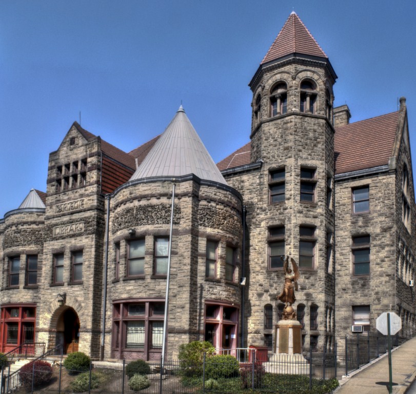
Carnegie Free Library of Braddock
Monument and historic site · National Register of Historic Places · 1.1 mi
Carnegie library in Pennsylvania

Gardner-Bailey House
Monument and historic site · National Register of Historic Places · 2.2 mi
Historic house in Pennsylvania, United States
George Westinghouse Bridge
Bridge · National Register of Historic Places · 2.7 mi
Concrete arch bridge over Turtle Creek

Gladstone School
Monument and historic site · National Register of Historic Places · 3.0 mi
Historic building in Pittsburgh, Pennsylvania, United States

Hamnett Historic District
Monument and historic site · National Register of Historic Places · 2.7 mi
Historic district in Pennsylvania, United States
Hazelwood Brewing Company
Monument and historic site · National Register of Historic Places · 3.2 mi
Historic former brewery in the Hazelwood neighborhood of Pittsburgh, Pennsylvania

Homestead Grays Bridge
Bridge · National Register of Historic Places · 1.9 mi
Bridge over the Monongahela River
Homestead Historic District
Monument and historic site · National Register of Historic Places · 1.2 mi
Historic district in Pennsylvania, United States
Homestead station
Monument and historic site · National Register of Historic Places · 1.5 mi
Former train station in Homestead, Pennsylvania

John F. Singer House
Monument and historic site · National Register of Historic Places · 3.2 mi
Listed on the National Register of Historic Places in Wilkinsburg, Pennsylvania
John Woods House
Monument and historic site · National Register of Historic Places · 3.3 mi
Listed on the National Register of Historic Places
21 more on the map.
Parks, trails and playgrounds15





3 more on the map.
Restaurants and cafes34

Eighth and Hays Wine Bar and Brick Oven
Restaurant · Pizza, Italian, Cheese, Sandwich · 1.5 mi
130 West 8th Avenue, Homestead
We-Th 16:00-22:00; Fr-Sa 16:00-00:00
MeLyng Restaurant
Restaurant · Vietnamese · 1.5 mi
213 West 8th Avenue, Homestead
Mo-Fr 12:00-21:00; Sa 16:00-21:30

Duke's Upper Deck Cafe
Restaurant · Burger, American, Pizza · 1.5 mi
122 West 8th Avenue, Homestead
Mo-Fr 11:00-00:00; Sa 12:00-02:00
Homestead Capri Pizza and Bar
Restaurant · Pizza · 1.4 mi
820 Amity Street, Homestead
Mo-Th 10:00-01:00; Fr-Sa 10:00-01:30; Su 11:00-23:00

Olive & Beans
Cafe · Coffee Shop, Breakfast, Sandwich · 0.9 mi
2615 Main Street, Munhall
Mo-Sa 07:00-15:00
Asian House
Restaurant · Chinese · 1.5 mi
1300 Hoffman Boulevard, West Mifflin

22 more on the map.
Where to stay1
Churches and places of worship37
Saint Gregory Russian Orthodox Church
Church · Russian Orthodox · 1.0 mi
214 East 15th Avenue, Homestead
Homestead United Presbyterian Church
Church · Presbyterian · 1.3 mi
908 Ann Street
Shopping12
Gas and EV charging6
Schools, colleges and libraries65
Carnegie Free Library of Swissvale
Library · 1.6 mi
1800 Monongahela Avenue, Swissvale
Healthcare3
Map of Whitaker
217 places. The map loads OpenStreetMap tiles when you open it.
Climate by month
Monthly table
| Month | High | Low | Rain |
|---|---|---|---|
| Jan | 38°F | 22°F | 3.2 in |
| Feb | 40°F | 22°F | 2.7 in |
| Mar | 50°F | 29°F | 3.3 in |
| Apr | 62°F | 40°F | 3.2 in |
| May | 72°F | 51°F | 3.9 in |
| Jun | 80°F | 60°F | 4.7 in |
| Jul | 84°F | 64°F | 3.8 in |
| Aug | 83°F | 63°F | 3.7 in |
| Sep | 76°F | 56°F | 3.3 in |
| Oct | 65°F | 44°F | 2.9 in |
| Nov | 53°F | 35°F | 2.9 in |
| Dec | 42°F | 28°F | 3.0 in |
U.S. Climate Normals 1991-2020 for Braddock Lock 2 (1 mi away), NOAA NCEI.
People and cost of living
American Community Survey 5-year estimates, 2020-2024, U.S. Census Bureau. Estimates have margins of error, larger for small towns.
Disaster history
Allegheny County has had 8 federal disaster declarations since 2000, most often for hurricanes.
- 2020-03-30: Covid-19 Pandemic (Biological)
- 2020-03-13: Covid-19 (Biological)
- 2013-10-01: Severe Storms, Tornadoes, And Flooding (Severe Storm)
- 2012-10-29: Hurricane Sandy (Hurricane)
- 2010-04-16: Severe Winter Storms And Snowstorms (Snowstorm)
- 2005-09-10: Hurricane Katrina (Hurricane)
OpenFEMA disaster declarations summaries.
Getting there and nearby towns
Allegheny County Airport (AGC) is the nearest airport with scheduled flights listed in OpenStreetMap, 4 miles away.
- Munhall 1 mi southwest, about 2 min by car
- Braddock Hills 2 mi northeast, about 3 min by car
- Wilkinsburg 3 mi north, about 5 min by car
- West Mifflin 3 mi south, about 5 min by car
- Baldwin 3 mi southwest, about 6 min by car
- Dravosburg 3 mi south, about 6 min by car
- McKeesport 5 mi southeast, about 7 min by car
- Pittsburgh 5 mi northwest, about 9 min by car
- Whitehall 6 mi southwest, about 10 min by car
- Monroeville 7 mi east, about 11 min by car
Drive times are estimates from straight-line distance, not routes.
Local news
Headlines from INDB, the NEMICO news database.
Reviews, tips and questions
Loading what members have shared...
Sources and licences
- NCES EDGE (Public domain): public schools
- NOAA NCEI U.S. Climate Normals 1991-2020 (Public domain): climate by month
- OpenFEMA (Public domain): disaster declarations
- OpenStreetMap contributors (ODbL 1.0): places, airports, map data
- U.S. Census Bureau (Public domain): population, income, housing, education, commute
- Wikidata (CC0 1.0): landmarks and historic places
- Wikimedia Commons (see each image): photos
- Wikipedia (CC BY-SA 4.0): overview and history text
Photo credits
- Rankinbr, Whitaker at English Wikipedia, Public domain
- Carrie Furnace Hot Metal Bridge from Whitaker, Hhm8, CC BY-SA 4.0
- Carrie Furnace Hot Metal Bridge from Whitaker (cropped), Hhm8, CC BY-SA 4.0
- Gardner-Bailey House, User:Nyttend, Public domain
- New gates to Kennywood (2005), Ski2007 of English Wikipedia, Public domain
- Bost Building, Daniel Case, CC BY-SA 3.0
- Homestead Grays Bridge river reflection, PixOnTrax at English Wikipedia, Public domain
- BCL 1024x768, Christopher Rolinson, CC BY 3.0 us
- Gladstone School Pittsburgh 1916 2, Unknown author Unknown author, Public domain
- John F. Singer House, Jack Boucher, Public domain
- Longfellow School - Corner, Max Chistokletov, CC BY-SA 3.0
- Pennsylvania Railroad Station in Wilkinsburg, User:Nyttend, Public domain
- Old Heidelberg Apartments, User:Nyttend, Public domain
- Sperling Building, Nyttend, Public domain
- Taylor Allderdice High School, Pittsburgh, Henry C. Schmitt, CC BY-SA 2.5
- Carrie Furnace030, PixOnTrax at English Wikipedia, Public domain
- Park Place School, Nyttend, Public domain
- American Jewish Museum,Pittsburgh, Pennsylvania, USA June 23 011, Melissalynnehiller , Leslie A. Golomb, Barbara Broff Goldman, CC BY 3.0
- HomesteadWorksBr, Rankinbr at English Wikipedia, Public domain
- AVRRbridge, PixOnTrax ( talk ) ( Uploads ) / PixOnTrax at English Wikipedia, Public domain
- Glenwoodbridge, PixOnTrax at English Wikipedia, Public domain
- St Nicholas Carpatho-Rusyn church, Barrettsprivateers, CC BY 4.0
- Fern Hollow Bridge from southwest (1), May 2024, Mr. Matté (if there is an issue with this image, contact me using this image's Commons talk page , my Commons user talk page , or my English Wikipedia user talk page ; I'll know about it a lot faster), CC BY-SA 4.0
- Rankin Bridge and Carrie Furnace Development, Hhm8, CC BY-SA 4.0
- Oo IMG 20150430 151401 (23610541963), hhm8, CC0
- 20070520 20 Pittsburgh, Pennsylvania (22658270357), David Wilson from Oak Park, Illinois, USA, CC BY 2.0
- Hot Metal Bridge Approach (5762346004) (2), reivax from Washington, DC, USA, CC BY-SA 2.0
- Carrie Furnace (2192157438), Jason Pratt from Pittsburgh, PA, CC BY 2.0
- Carrie Furnace - panoramio, FishSpeaker, CC BY 3.0
- Carrie Furnaces, Rankin PA (8907643987), Roy Luck, CC BY 2.0
- ISS042-E-117365 - View of Earth, Earth Science and Remote Sensing Unit , Lyndon B. Johnson Space Center, Public domain
- ISS042-E-117366 - View of Earth, Earth Science and Remote Sensing Unit , Lyndon B. Johnson Space Center, Public domain
- ISS042-E-117364 - View of Earth, Earth Science and Remote Sensing Unit , Lyndon B. Johnson Space Center, Public domain
- ISS042-E-117367 - View of Earth, Earth Science and Remote Sensing Unit , Lyndon B. Johnson Space Center, Public domain
- ISS042-E-119589 - View of Earth, Earth Science and Remote Sensing Unit , Lyndon B. Johnson Space Center, Public domain
- Pipes and valves, Carrie Furnaces, Rankin PA (8908294696), Roy Luck, CC BY 2.0
- Diesel switcher and Carrie Furnaces, Rankin PA (8907668281), Roy Luck, CC BY 2.0
- Switcher locomotive, Carrie Furnaces, Rankin PA (8907668733), Roy Luck, CC BY 2.0
- Switcher locomotive, Carrie Furnaces, Rankin PA (8907669439), Roy Luck, CC BY 2.0
- Rotary dump, Carrie Furnaces, Rankin PA (8786585553), Roy Luck, CC BY 2.0


Page built October 30, 2026. Spotted a mistake? Tell us or suggest a place.