


Wilkinsburg, Pennsylvania
Wilkinsburg is a borough of 14,027 people in Allegheny County, Pennsylvania, founded in 1790.
Why visit Wilkinsburg
Townapedia lists 50 museums and landmarks, 29 parks and trails, 32 places to eat and 19 attractions in and around town.
Highlights include Brilliant Branch Railroad Bridge, Brilliant Cutoff Viaduct of the Pennsylvania Railroad, The Frick Pittsburgh and Alpha Terrace Historic District.
July is the warmest month, with average highs of 84°F; January lows average 22°F.
Weather in Wilkinsburg
Forecast from the National Weather Service. Full forecast
About Wilkinsburg
Wilkinsburg is a borough in Allegheny County, Pennsylvania, United States. The borough has a population of 14,349 as of the 2020 census. Wilkinsburg is part of the Pittsburgh metropolitan area. The borough was named for John Wilkins Jr., a United States Army officer who served as Quartermaster General of the United States Army from 1796 to 1802.
From the Wikipedia article Wilkinsburg, Pennsylvania (this version), under CC BY-SA 4.0.
Things to do19

Brilliant Branch Railroad Bridge
Bridge · 3.4 mi
Rail bridge over Allegheny River
Brilliant Cutoff Viaduct of the Pennsylvania Railroad
Bridge · 2.1 mi
Stone railroad bridge in Pittsburgh
Carrie Furnace Hot Metal Bridge
Bridge · 2.5 mi
Bridge over the Monongahela River

Chatham University
School · 2.8 mi
University in Pittsburgh, Pennsylvania
Fern Hollow Bridge
Bridge · 1.5 mi
Bridge in Pittsburgh, Pennsylvania, US built in 2022
Greenfield Bridge (2017)
Bridge · 3.6 mi
Bridge in Pittsburgh (opened 2017)

Kelly-Strayhorn Theater
Cinema and theater · 3.0 mi
Performing arts centre in Pittsburgh, Pennsylvania, United States
Lovelace Theatre
Cinema and theater · 3.0 mi
Former puppet theater in Pittsburgh, Pennsylvania, United States
Pinkerton's Landing Bridge
Bridge · 2.4 mi
Train bridge over Monongahela River
Rankin Bridge
Bridge · 2.7 mi
Bridge in Allegheny County, Pennsylvania

Shiloh Farm Stand
Farm and orchard · 1.5 mi
2709 Thomas Boulevard, Pittsburgh
May 01-Oct 31 Th 14:30-18:30
7 more on the map.
Museums and landmarks50


Alpha Terrace Historic District
Monument and historic site · National Register of Historic Places · 3.1 mi
Historic district in Pittsburgh, Pennsylvania
Baxter High School
Monument and historic site · National Register of Historic Places · 1.1 mi
High school in Pennsylvania, United States

Bost Building
Monument and historic site · National Register of Historic Places · 2.9 mi
Building in Pennsylvania, United States
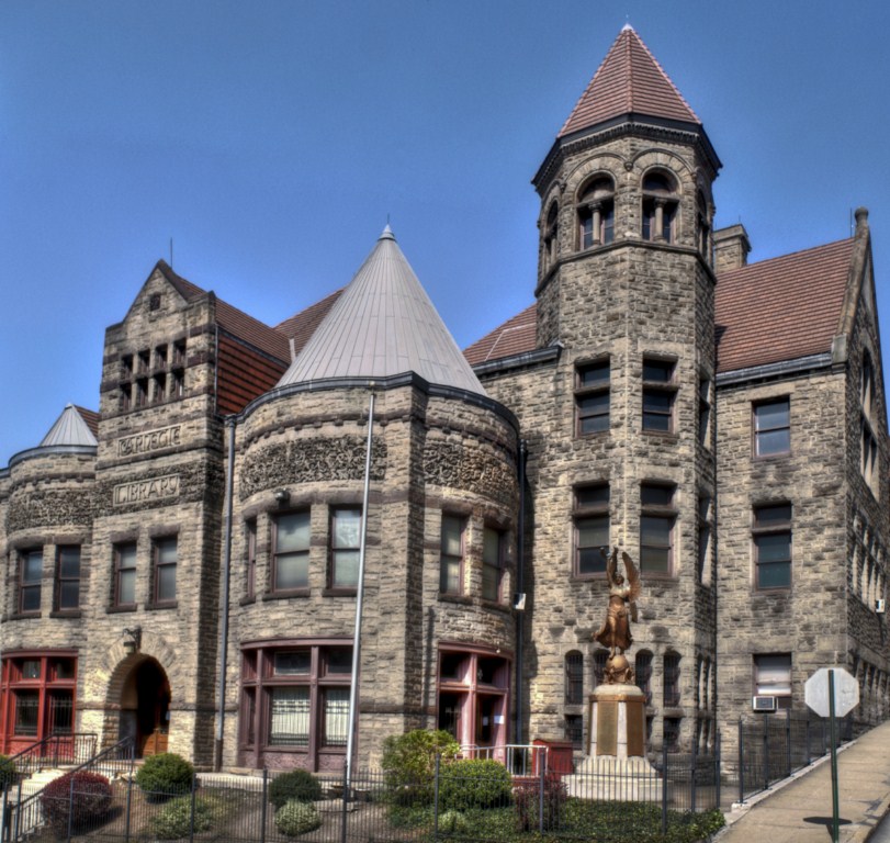
Carnegie Free Library of Braddock
Monument and historic site · National Register of Historic Places · 3.0 mi
Carnegie library in Pennsylvania
East Liberty Commercial Historic District
Monument and historic site · National Register of Historic Places · 3.0 mi
Historic district in Pittsburgh, Pennsylvania

Gardner-Bailey House
Monument and historic site · National Register of Historic Places · 1.1 mi
Historic house in Pennsylvania, United States
Hamnett Historic District
Monument and historic site · National Register of Historic Places · 0.6 mi
Historic district in Pennsylvania, United States
Henry Koerner House
Monument and historic site · National Register of Historic Places · 2.9 mi
House of Henry Koerner in Pittsburgh, Pennsylvania, United States

Highland Building
Monument and historic site · National Register of Historic Places · 2.9 mi
Building in Pittsburgh, USA

Highland Towers Apartments
Monument and historic site · National Register of Historic Places · 2.9 mi
High-rise building in Pennsylvania, United States of America

Homestead Grays Bridge
Monument and historic site · National Register of Historic Places · 3.3 mi
Bridge over the Monongahela River
38 more on the map.
Parks, trails and playgrounds29


Westinghouse Park
Park · 1.7 mi
Park was once the property of George Westinghouse. It was the site his home "Solitude". Donated to the city of Pittsburgh after his...
Thomas Boulevard, Pittsburgh

Mellon Park
Park · 2.4 mi
Park in Pennsylvania, United States of America, United States of America
Blackridge Park
Park · 1.4 mi
I love this park, even though it is not well-maintained.

17 more on the map.
Restaurants and cafes32



Hemlock House
Restaurant · American, Burger · 1.4 mi
1126 South Braddock Avenue
Mo-Th 11:00-00:00; Fr 11:00-02:00; Sa 10:00-02:00; Su 10:00-23:00
Spigolo
Cafe · Coffee Shop, Tea · 1.0 mi
101 Edgewood Avenue
Su 08:00-14:00; Tu-Fr 07:00-16:00; Sa 08:00-16:00
Rockin' Cat Organic Coffee & Tea Point Breeze
Cafe · Coffee Shop, Tea, Tea Shop, Teahouse · 1.7 mi
7111 Reynolds Street, Pittsburgh
Mo-Fr 07:00-16:00,Sa-Su 09:00-16:00

Biddle's Escape
Cafe · Coffee Shop · 1.1 mi
401 Biddle Avenue, Wilkinsburg
Mo-Sa 08:00-19:00; Su 08:00-16:00
Commonplace Coffee
Cafe · Coffee Shop · 1.2 mi
7514 Thomas Boulevard
Mo-Su 07:00-18:00
D's Six Packs and Dogs
Restaurant · Hot Dog, Pizza · 1.4 mi
1118 South Braddock Avenue, Pittsburgh
Su-We 11:00-23:00, Th-Sa 11:00-24:00
Madeleine Bakery and Bistro
Cafe · Coffee Shop, Pastry · 1.1 mi
609 South Trenton Avenue, Pittsburgh
Tu-Sa 08:00-16:00; Su 08:00-14:00
20 more on the map.
History
Wilkinsburg is located in an area of the Appalachian Plateau where various land and water transportation routes join, an area which Native Americans have inhabited for thousands of years. Geologically, Wilkinsburg centers on a valley going through the hills located east of the three rivers confluence: namely, the Allegheny River, the Monongahela River, and the Ohio River. The Wilkinsburg valley eased passage by land through the barrier of the Appalachian Mountains, for example travel to and from Philadelphia and other Atlantic coast areas, including travel through the Cumberland Gap. The nearby meeting of the three rivers facilitated passage by water and by land alongside the rivers, which eventually joining the south-flowing Mississippi River, meeting the Gulf of Mexico, and so linking with oceanic trade. This made Wilkinsburg a nexus for divergent routes, where travel from the east and from travel from the south intersected, together with other transportation routes to the north and west. A vital section of the major land road or pathway passage to the east is now Penn Avenue, still a main street of Wilkinsburg.
From the History section of Wilkinsburg, Pennsylvania on Wikipedia, under CC BY-SA 4.0.
Churches and places of worship69
Beulah Presbyterian Church
Church · National Register of Historic Places · 1.3 mi
Calvary Episcopal Church
Church · National Register of Historic Places · 2.7 mi
Shadyside Presbyterian Church
Church · National Register of Historic Places · 3.5 mi
Covenant Fellowship Reformed Presbyterian Church
Church · Reformed
1300 Swissvale Avenue, Wilkinsburg
Holy Rosary Church
Church · Roman Catholic · 1.6 mi
7114 Kelly Street, Pittsburgh
Shopping12
Gas and EV charging11
Schools, colleges and libraries83
Carnegie Library of Pittsburgh - Homewood
Library · 1.6 mi
7101 Hamilton Avenue, Pittsburgh
Western Pennsylvania School for the Deaf
School · 0.8 mi
300 East Swissvale Avenue, Pittsburgh
Wilkinsburg Public Libraary: Eastridge Branch
Library · 1.2 mi
1900 Graham Boulevard, Pittsburgh
Dr Cleveland Steward Jr El Sch
School · 5.8 mi
5000 Gateway Campus Blvd, Monroeville
Healthcare3
Map of Wilkinsburg
250 places. The map loads OpenStreetMap tiles when you open it.
Climate by month
Monthly table
| Month | High | Low | Rain |
|---|---|---|---|
| Jan | 38°F | 22°F | 3.2 in |
| Feb | 40°F | 22°F | 2.7 in |
| Mar | 50°F | 29°F | 3.3 in |
| Apr | 62°F | 40°F | 3.2 in |
| May | 72°F | 51°F | 3.9 in |
| Jun | 80°F | 60°F | 4.7 in |
| Jul | 84°F | 64°F | 3.8 in |
| Aug | 83°F | 63°F | 3.7 in |
| Sep | 76°F | 56°F | 3.3 in |
| Oct | 65°F | 44°F | 2.9 in |
| Nov | 53°F | 35°F | 2.9 in |
| Dec | 42°F | 28°F | 3.0 in |
U.S. Climate Normals 1991-2020 for Braddock Lock 2 (4 mi away), NOAA NCEI.
People and cost of living
American Community Survey 5-year estimates, 2020-2024, U.S. Census Bureau. Estimates have margins of error, larger for small towns.
Disaster history
Allegheny County has had 8 federal disaster declarations since 2000, most often for hurricanes.
- 2020-03-30: Covid-19 Pandemic (Biological)
- 2020-03-13: Covid-19 (Biological)
- 2013-10-01: Severe Storms, Tornadoes, And Flooding (Severe Storm)
- 2012-10-29: Hurricane Sandy (Hurricane)
- 2010-04-16: Severe Winter Storms And Snowstorms (Snowstorm)
- 2005-09-10: Hurricane Katrina (Hurricane)
OpenFEMA disaster declarations summaries.
Getting there and nearby towns
Allegheny County Airport (AGC) is the nearest airport with scheduled flights listed in OpenStreetMap, 7 miles away.
- Munhall 4 mi southwest, about 6 min by car
- Pittsburgh 5 mi west, about 9 min by car
- Baldwin 6 mi southwest, about 9 min by car
- Monroeville 6 mi east, about 10 min by car
- West Mifflin 6 mi south, about 10 min by car
- McKeesport 7 mi south, about 12 min by car
- Plum 8 mi northeast, about 12 min by car
- Whitehall 8 mi southwest, about 14 min by car
- Allison Park 10 mi northwest, about 16 min by car
- Jefferson Hills 11 mi south, about 17 min by car
Drive times are estimates from straight-line distance, not routes.
Local news
Headlines from INDB, the NEMICO news database.
Reviews, tips and questions
Loading what members have shared...
Sources and licences
- NCES EDGE (Public domain): public schools
- NOAA NCEI U.S. Climate Normals 1991-2020 (Public domain): climate by month
- OpenFEMA (Public domain): disaster declarations
- OpenStreetMap contributors (ODbL 1.0): places, airports, map data
- U.S. Census Bureau (Public domain): population, income, housing, education, commute
- Wikidata (CC0 1.0): elevation, founding date, time zone, website, landmarks and historic places
- Wikimedia Commons (see each image): photos
- Wikipedia (CC BY-SA 4.0): overview and history text
Photo credits
- Wilkinsburg municipal building and library, User:Nyttend, Public domain
- Singer House, Wilkinsburg, Nyttend, Public domain
- South Avenue UMC, Wilkinsburg, Nyttend, Public domain
- Pennsylvania Railroad Station in Wilkinsburg, User:Nyttend, Public domain
- Wilkinsburg station 1960s postcard, Unknown author Unknown author, Public domain
- 20070520 30 Wilkinsburg, Pennsylvania (23101127865), David Wilson from Oak Park, Illinois, USA, CC BY 2.0
- 20050604 42 Wilkinsburg, PA (10908979793), David Wilson from Oak Park, Illinois, USA, CC BY 2.0
- 19660415 19 PAT 1539 Rebecca & Hay, Wilkinsburg, Pennsylvania (7922952532), David Wilson from Oak Park, Illinois, USA, CC BY 2.0
- 19660415 19 PAT 1539 Rebecca & Hay, Wilkinsburg, Pennsylvania, David Wilson from Oak Park, Illinois, USA, CC BY 2.0
- Westinghouse Park, Qwerty123uiop, CC BY-SA 3.0
- Whitehill-Gleason Motors, User:Nyttend, Public domain
- Gardner-Bailey House, User:Nyttend, Public domain
- ShadysidePresbyterianChurchPHLF, Tim Engleman from Saxonburg, PA, CC BY-SA 2.0
- Highland Towers Apartments, User:Nyttend, Public domain
- CalvaryEpiscopalShadysidePHLF, Tim Engleman from Saxonburg, PA, CC BY-SA 2.0
- Friendship Elementary School, Nyttend, Public domain
- Longfellow School - Corner, Max Chistokletov, CC BY-SA 3.0
- Moreland-Hoffstot House, Nyttend, Public domain
- Highland Building, Eli Pousson, CC BY-SA 2.0
- Old Heidelberg Apartments, User:Nyttend, Public domain
- Bost Building, Daniel Case, CC BY-SA 3.0
- McCook Mansion - Pittsburgh, PA - DSC05088-001, Daderot, CC0
- Taylor Allderdice High School, Pittsburgh, Henry C. Schmitt, CC BY-SA 2.5
- Homestead Grays Bridge river reflection, PixOnTrax at English Wikipedia, Public domain
- BCL 1024x768, Christopher Rolinson, CC BY 3.0 us
- Park Place School, Nyttend, Public domain
- Sperling Building, Nyttend, Public domain
- Franklin Avenue, Pittsburgh (30385767772), Tony Webster from Minneapolis, Minnesota, CC BY-SA 2.0
- John F. Singer House, Jack Boucher, Public domain
- 19680526 26 PAT M454 1636 @ Oakwood Loop (3294311706), David Wilson from Oak Park, Illinois, USA, CC BY 2.0
- 19680526 35 PAT 1636 1646 @ Oakwood Loop (3293515511), David Wilson from Oak Park, Illinois, USA, CC BY 2.0
- 19680526 25 Oakwood Loop (3293486743), David Wilson from Oak Park, Illinois, USA, CC BY 2.0
- Inglenook Place city steps East Hills Pittsburgh, Lzurowski, CC BY-SA 4.0
- 19680526 27 PAT 1636 Oakwood Ave. @ Nimick St. (3293486817), David Wilson from Oak Park, Illinois, USA, CC BY 2.0
- Modeling Picture ki, Thomasbrisk, CC BY-SA 4.0
- JRabinowitz 15Jul2019 stone, DonKrieger, CC BY-SA 4.0
- Train pgh line (30771696764), hhm8, CC BY 2.0
- Tunnel (31575897186), hhm8, CC BY 2.0
- WesternPASchoolDeafEdgewood, David Fulmer from Pittsburgh, CC BY 2.0
- Hamnett station (31488552601), hhm8, CC BY 2.0


Page built October 30, 2026. Spotted a mistake? Tell us or suggest a place.