



White Settlement, Texas
White Settlement is a city of 18,150 people in Tarrant County, Texas.
Why visit White Settlement
Townapedia lists 9 museums and landmarks, 16 parks and trails, 72 places to eat, 20 places to stay and 2 attractions in and around town.
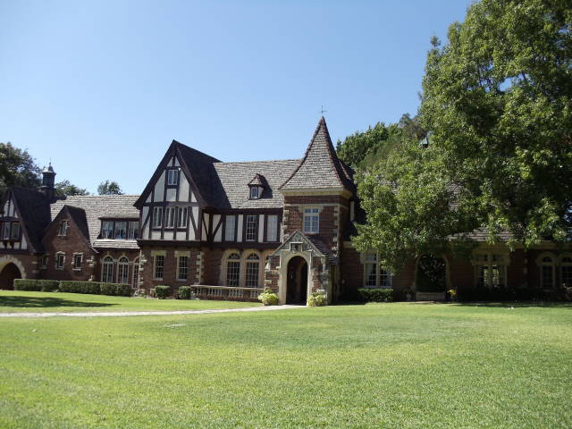
Highlights include Cinemark, Ridglea Theatre, Westover Manor and Leonard Park.
July is the warmest month, with average highs of 97°F; January lows average 37°F.
Weather in White Settlement
Forecast from the National Weather Service. Full forecast
About White Settlement
White Settlement is a city in Tarrant County, Texas, United States, and a northwestern suburb of Fort Worth. Its population was estimated to be 18,084 in 2021. The city is bordered by Lockheed Martin and the Naval Air Station Joint Reserve Base Fort Worth.
From the Wikipedia article White Settlement, Texas (this version), under CC BY-SA 4.0.
Things to do2

Museums and landmarks9

Ridglea Theatre
Monument and historic site · National Register of Historic Places · 3.2 mi
Movie theater in Fort Worth, Texas, United States
Westover Manor
Monument and historic site · National Register of Historic Places · 3.4 mi
Historic place in Fort Worth, Tarrant County, Texas


William J. Bryce House
Monument and historic site · National Register of Historic Places · 4.1 mi
Fort Worth, Texas, listed on the NRHP in Texas
Consolidated Vultee Aircraft Corporation Plant No. 4
Monument and historic site · 1.0 mi
Home Town of Texas Confederate General H.P. Mabry
Monument and historic site · 1.4 mi
Home Town of Texas Confederate Major K.M. Van Zandt
Monument and historic site · 1.4 mi
Parks, trails and playgrounds16


Hawks Creek Golf Club
Golf course · 1.9 mi
6520 6520 White Settlement Rd, Westworth Village

4 more on the map.
Restaurants and cafes72


CS Cajun Seafood House
Restaurant · Seafood · 2.2 mi
9116 Camp Bowie W Boulevard, Fort Worth
Su-Th 11:00-21:00; Fr-Sa 11:00-22:00
Skillman Wok
Restaurant · Chinese · 2.2 mi
9116 Camp Bowie W Boulevard, Fort Worth
Mo-Su 11:00-21:00; Fr-Sa 11:00-22:00

Starbucks
Cafe · Coffee Shop · 1.1 mi
132 West Loop 820 South, Fort Worth
Mo-Fr 05:00-21:00; Sa-Su 05:30-21:00
The Point on Lake Worth
Restaurant · American, Chicken, Diner, Grill, Sandwich, Seafood · 2.0 mi
1349 Bomber Plant Road
Mo-Su 11:00-22:00
60 more on the map.
History
Even before the beginnings of a nearby military outpost, Fort Worth, white settlers took up refuge along a creek, later named Farmers Branch Creek. Before the end of 1841, settlers began arriving from Missouri, Illinois, Indiana, Kentucky, and Tennessee. In 1850, the area's first census showed the population consisted of 599 White Americans and 65 Black enslaved people. By the mid-1850s, many more settlers arrived, bringing with them more enslaved people.
The oldest street in White Settlement is White Settlement Road. This original trail led from the fort to the "white settlement" about eight miles west into Native American territory. As the Native Americans were forced from the area, and the settlement moved westward, the road followed. This was the only public road in White Settlement's early history.
While early life was not easy for the settlers, with frequent clashes with indigenous populations, White Settlement became a trading outpost. As the migrating settlers carved out homesteads among the various indigenous tribes, outsiders, and Native Americans referred to the area as "the white settlement."
In February 1942, Consolidated Aircraft Company began construction on the B-24 Liberator heavy bomber at Air Force Plant #4. Liberator Village, as it became known, consisted of housing units across the city to house aircraft workers.
From the History section of White Settlement, Texas on Wikipedia, under CC BY-SA 4.0.
Where to stay20
La Quinta Inn & Suites Fort Worth West - I-30
Motel and hotel · 1.7 mi
7310 Calmont Avenue, Fort Worth
Fairfield Inn & Suites Fort Worth I-30 West Near NAS JRB
Motel and hotel · 2.0 mi
6851 West Freeway, Fort Worth
Churches and places of worship23
Birchman Baptist Church
Church · Baptist · 1.6 mi
9100 North Normandale Street, Fort Worth
Castleberry Baptist Church
Church · Baptist · 1.7 mi
1250 North Jim Wright Freeway, White Settlement
Empowerment Life Cathedral
Church · Pentecostal · 2.1 mi
8000 West Elizabeth Lane
Grace Baptist Church
Church · Baptist · 2.2 mi
1501 West Loop 820 North, Fort Worth
West Freeway Church of Christ
Church · Church Of Christ · 1.1 mi
1900 South Las Vegas Trail, White Settlement
Western Hills United Methodist Church
Church · Methodist · 1.4 mi
2820 Laredo Drive
Shopping17
Gas and EV charging19
Schools, colleges and libraries48
Healthcare7
Walgreens
Clinic and pharmacy · 2.1 mi
8600 Camp Bowie West Boulevard, Fort Worth
CareNow Urgent Care
Clinic and pharmacy · 1.1 mi
454 North Jim Wright Freeway, White Settlement
Map of White Settlement
233 places. The map loads OpenStreetMap tiles when you open it.
Climate by month
Monthly table
| Month | High | Low | Rain |
|---|---|---|---|
| Jan | 59°F | 37°F | 1.9 in |
| Feb | 63°F | 41°F | 2.0 in |
| Mar | 70°F | 49°F | 3.2 in |
| Apr | 78°F | 56°F | 2.5 in |
| May | 85°F | 65°F | 3.6 in |
| Jun | 92°F | 73°F | 4.2 in |
| Jul | 97°F | 76°F | 2.0 in |
| Aug | 97°F | 76°F | 1.8 in |
| Sep | 90°F | 70°F | 2.6 in |
| Oct | 79°F | 58°F | 3.9 in |
| Nov | 68°F | 48°F | 2.6 in |
| Dec | 60°F | 40°F | 2.2 in |
U.S. Climate Normals 1991-2020 for Ft Worth Nas (1 mi away), NOAA NCEI.
People and cost of living
American Community Survey 5-year estimates, 2020-2024, U.S. Census Bureau. Estimates have margins of error, larger for small towns.
Disaster history
Tarrant County has had 19 federal disaster declarations since 2000, most often for hurricanes.
- 2021-02-19: Severe Winter Storms (Severe Ice Storm)
- 2021-02-14: Severe Winter Storm (Severe Ice Storm)
- 2020-08-24: Tropical Storms Marco And Laura (Hurricane)
- 2020-03-25: Covid-19 Pandemic (Biological)
- 2020-03-13: Covid-19 (Biological)
- 2017-08-25: Hurricane Harvey (Hurricane)
OpenFEMA disaster declarations summaries.
Getting there and nearby towns
Naval Air Station Joint Reserve Base Fort Worth (Carswell Field) (FWH) is the nearest airport with scheduled flights listed in OpenStreetMap, 2 miles away.
- Benbrook 5 mi south, about 9 min by car
- Fort Worth 7 mi east, about 11 min by car
- Saginaw 9 mi northeast, about 15 min by car
- Azle 11 mi northwest, about 17 min by car
- Haltom City 12 mi east, about 19 min by car
- Forest Hill 13 mi southeast, about 21 min by car
- Crowley 14 mi southeast, about 22 min by car
- Watauga 15 mi northeast, about 23 min by car
- North Richland Hills 16 mi northeast, about 25 min by car
- Hurst 17 mi east, about 28 min by car
Drive times are estimates from straight-line distance, not routes.
Local news
Headlines from INDB, the NEMICO news database.
Reviews, tips and questions
Loading what members have shared...
Sources and licences
- NCES EDGE (Public domain): public schools
- NOAA NCEI U.S. Climate Normals 1991-2020 (Public domain): climate by month
- OpenFEMA (Public domain): disaster declarations
- OpenStreetMap contributors (ODbL 1.0): places, airports, map data
- U.S. Census Bureau (Public domain): population, income, housing, education, commute
- Wikidata (CC0 1.0): elevation, founding date, time zone, website, landmarks and historic places
- Wikimedia Commons (see each image): photos
- Wikipedia (CC BY-SA 4.0): overview and history text
Photo credits
- 2024.Web-WSPD Building, NorthTexasHistory, CC BY-SA 4.0
- BryceHouse1 (1 of 1), Renelibrary, CC BY-SA 4.0
- Westover, Renelibrary, CC BY-SA 3.0
- Exterior of All Saints Episcopal Church (ACNA), Fort Worth, Texas, greg westfall, CC BY 2.0
Page built October 30, 2026. Spotted a mistake? Tell us or suggest a place.