


Plum, Pennsylvania
Plum is a borough of 26,723 people in Allegheny County, Pennsylvania, founded in 1788.
Why visit Plum
Townapedia lists 28 museums and landmarks, 44 parks and trails, 57 places to eat, 4 places to stay and 10 attractions in and around town.
Highlights include Bessemer & Lake Erie Railroad Bridge, C. L. Schmitt Bridge, Allegheny River Lock and Dam No. 3 and Oakmont Country Club.
July is the warmest month, with average highs of 83°F; January lows average 19°F.
Weather in Plum
Forecast from the National Weather Service. Full forecast
About Plum
Plum is a borough in Allegheny County, Pennsylvania, United States. The population was 27,144 at the 2020 census. A suburb of the Pittsburgh metropolitan area, it is located northeast of the city in what is commonly referred to as the East Hills suburbs.
From the Wikipedia article Plum, Pennsylvania (this version), under CC BY-SA 4.0.
Things to do10

Bessemer & Lake Erie Railroad Bridge
Bridge · 4.5 mi
Bridge over the Allegheny River in Pennsylvania

C. L. Schmitt Bridge
Bridge · 4.5 mi
Bridge in Pennsylvania, United States

Jonathon Hulton Bridge
Bridge · 5.5 mi
Bridge over the Allegheny River in Pennsylvania


Museums and landmarks28
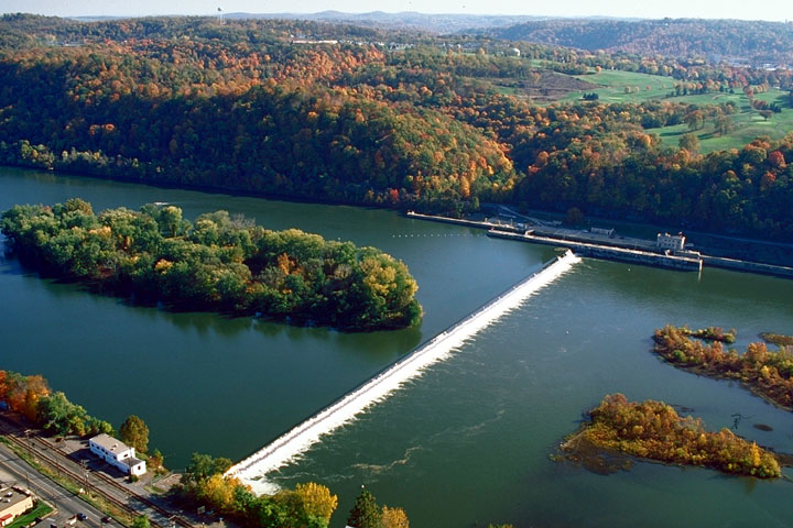
Allegheny River Lock and Dam No. 3
Monument and historic site · National Register of Historic Places · 4.3 mi
Place in Pennsylvania listed on National Register of Historic Places

Oakmont Country Club
Monument and historic site · National Register of Historic Places · 4.4 mi
Country club in the eastern United States
Rachel Carson Homestead
Monument and historic site · National Register of Historic Places · 3.6 mi
Birthplace of Rachel Carson

Byerly House
Monument and historic site · National Register of Historic Places · 4.9 mi
Historic house in Pennsylvania, United States
Dr. Thomas R. Kerr House and Office
Monument and historic site · National Register of Historic Places · 5.0 mi
Oakmont, Pennsylvania, NRHP-listed
Logans Ferry Powder Works Historic District
Monument and historic site · National Register of Historic Places · 2.7 mi
Historic district in Pennsylvania, United States
Longue Vue Club and Golf Course
Monument and historic site · National Register of Historic Places · 6.0 mi
Golf course in Verona, Pennsylvania


New Kensington Downtown Historic District
Monument and historic site · National Register of Historic Places · 4.5 mi
Historic district in New Kensington, Pennsylvania
New Kensington Production Works Historic District
Monument and historic site · National Register of Historic Places · 4.6 mi
Historic district in Pennsylvania, United States
Dam No. 3
Monument and historic site · 4.3 mi
The approximately 30-foot high fixed-crest dam is 1,434 feet long. Although the locks rest on bedrock, the dam sits on timber piles....
Lehner Grain-and-Cider Mill and House
Monument and historic site · National Register of Historic Places · 5.1 mi

16 more on the map.
Parks, trails and playgrounds44

Boyce Park
Park · 2.4 mi
County park in Allegheny County, Pennsylvania


32 more on the map.
Restaurants and cafes57


Koi Steakhouse & Sushi Bar
Restaurant · Asian · 4.3 mi
1782 Golden Mile Highway, Monroeville
Mo-Th 11:00-21:30; Fr-Sa 11:00-22:30; Su 12:00-21:00
Outback Steakhouse
Restaurant · American, Steak · 4.4 mi
3000 Mosside Boulevard, Monroeville
Mo-Th 11:00-21:30; Fr-Sa 11:00-22:00; Su 11:00-21:00

Azan Wok
Restaurant · Asian · 3.6 mi
2352 Golden Mile Highway, Plum
Mo-Th 11:00-21:30; Fr-Sa 11:00-22:30; Su 12:00-21:00
Fox's Pizza
Restaurant · Pizza · 3.5 mi
2374 Golden Mile Highway, Plum
Mo-Th 10:30-22:00; Fr-Sa 10:30-23:00; Su 12:00-22:00
45 more on the map.
History
Plum Township was founded on December 18, 1788, as one of the original seven townships of Allegheny County. It originally extended as far south as Versailles (modern-day North Versailles Township), east to the county line, west to Pitt Township, and north to the Allegheny River. Plum has shrunk greatly over the years in area, but still remains among the larger municipalities in Allegheny County.
The 1889 history of Allegheny County, Pennsylvania, describes the township as having "no villages of importance", but listed the first postoffice, Antrim, 1840–1857; New Texas, a hamlet, in the geographic center of the township with "the usual mechanics, local stores, etc.", post office from 1856; and Logan's Ferry, on the Allegheny River and Allegheny Valley railroad, in the northeastern part of the township, deriving its name from early settler Alexander Logan and family, post office from 1844.
From the History section of Plum, Pennsylvania on Wikipedia, under CC BY-SA 4.0.
Where to stay4
Churches and places of worship53
Mount Saint Peter Church
Church · Roman Catholic · 4.3 mi
100 Freeport Road, New Kensington
Mount St. Peter Church
Church · National Register of Historic Places · 4.3 mi
Monroeville Assembly of God
Church · Assemblies Of God · 4.1 mi
4561 Old William Penn Highway, Monroeville
Pittsburgh Korean Assembly of God
Church · Assemblies Of God · 4.2 mi
308 Garden City Drive, Monroeville
Good Shepherd Lutheran Church
Church · Lutheran · 4.0 mi
4503 Old William Penn Highway, Monroeville
Holiday Park United Methodist Church
Church · Methodist · 3.5 mi
81 Sandune Drive, Plum
Pittsburgh East Chinese Church
Church · Presbyterian · 3.9 mi
398 Hochberg Road, Monroeville
Saint Bernadette Catholic Church
Church · Catholic · 4.4 mi
245 Azalea Drive, Monroeville
Shopping15
Gas and EV charging15
Schools, colleges and libraries63
Healthcare9
Passport Health Monroeville Travel Clinic
Clinic and pharmacy · 4.3 mi
244 Center Road, Monroeville
UPMC health plan connect centrer
Clinic and pharmacy · 4.4 mi
1768 Golden Mile Highway
Map of Plum
250 places. The map loads OpenStreetMap tiles when you open it.
Climate by month
Monthly table
| Month | High | Low | Rain |
|---|---|---|---|
| Jan | 36°F | 19°F | 3.4 in |
| Feb | 40°F | 21°F | 2.9 in |
| Mar | 49°F | 28°F | 3.7 in |
| Apr | 62°F | 38°F | 3.7 in |
| May | 72°F | 48°F | 3.9 in |
| Jun | 79°F | 58°F | 4.5 in |
| Jul | 83°F | 62°F | 4.5 in |
| Aug | 82°F | 60°F | 3.6 in |
| Sep | 76°F | 54°F | 4.2 in |
| Oct | 64°F | 43°F | 3.3 in |
| Nov | 51°F | 32°F | 3.3 in |
| Dec | 42°F | 26°F | 3.7 in |
U.S. Climate Normals 1991-2020 for Acmetonia Lock 3 (4 mi away), NOAA NCEI.
People and cost of living
American Community Survey 5-year estimates, 2020-2024, U.S. Census Bureau. Estimates have margins of error, larger for small towns.
Disaster history
Allegheny County has had 8 federal disaster declarations since 2000, most often for hurricanes.
- 2020-03-30: Covid-19 Pandemic (Biological)
- 2020-03-13: Covid-19 (Biological)
- 2013-10-01: Severe Storms, Tornadoes, And Flooding (Severe Storm)
- 2012-10-29: Hurricane Sandy (Hurricane)
- 2010-04-16: Severe Winter Storms And Snowstorms (Snowstorm)
- 2005-09-10: Hurricane Katrina (Hurricane)
OpenFEMA disaster declarations summaries.
Getting there and nearby towns
Allegheny County Airport (AGC) is the nearest airport with scheduled flights listed in OpenStreetMap, 14 miles away.
- New Kensington 5 mi north, about 8 min by car
- Monroeville 5 mi south, about 8 min by car
- Lower Burrell 6 mi north, about 9 min by car
- Murrysville 6 mi southeast, about 10 min by car
- Munhall 11 mi southwest, about 18 min by car
- Allison Park 12 mi northwest, about 20 min by car
- McKeesport 12 mi southwest, about 20 min by car
- Pittsburgh 13 mi west, about 20 min by car
- Baldwin 13 mi southwest, about 21 min by car
- Greensburg 17 mi southeast, about 27 min by car
Drive times are estimates from straight-line distance, not routes.
Local news
Headlines from INDB, the NEMICO news database.
Reviews, tips and questions
Loading what members have shared...
Sources and licences
- NCES EDGE (Public domain): public schools
- NOAA NCEI U.S. Climate Normals 1991-2020 (Public domain): climate by month
- OpenFEMA (Public domain): disaster declarations
- OpenStreetMap contributors (ODbL 1.0): places, airports, map data
- U.S. Census Bureau (Public domain): population, income, housing, education, commute
- Wikidata (CC0 1.0): landmarks and historic places
- Wikimedia Commons (see each image): photos
- Wikipedia (CC BY-SA 4.0): overview and history text
Photo credits
- Allegheny Islands State Park, C.W. Bill Young Lock and Dam, U.S. Army Corps of Engineers, Public domain
- Mount Saint Peter Church, Rudy4rachel ( talk ), Public domain
- Byerly House from the road, Nyttend, Public domain
- Liberty Theater, New Kensington, Fred S. Danner, Public domain
- Hulton Bridge - 20200706, Derek Kalinosky, CC BY-SA 4.0
- B&lerr, Jet Lowe, National Park Service, Public domain
Page built October 30, 2026. Spotted a mistake? Tell us or suggest a place.