




Why visit Winamac
Townapedia lists 4 museums and landmarks, 3 parks and trails, 6 places to eat and 1 attraction in and around town.
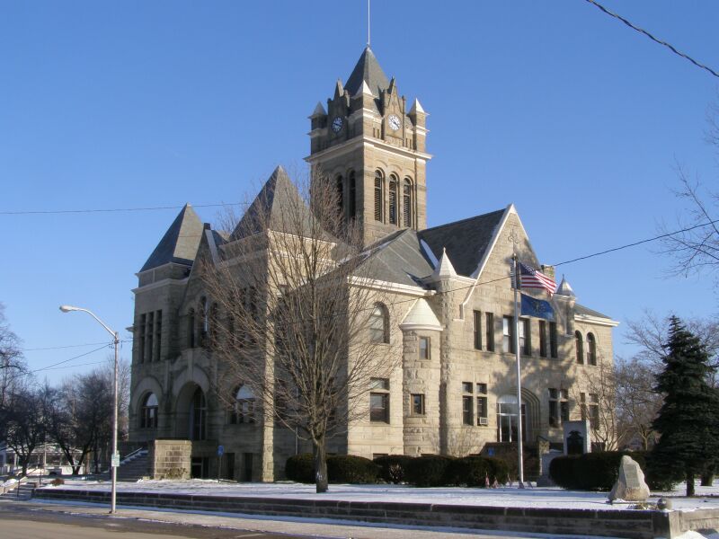
Highlights include Isis Theater, Dr. George W. Thompson House and Pulaski County Courthouse.
July is the warmest month, with average highs of 84°F; January lows average 16°F, and about 26 inches of snow fall in a normal year.
Weather in Winamac
Forecast from the National Weather Service. Full forecast
About Winamac
Winamac is a town in Monroe Township, Pulaski County, in the U.S. state of Indiana. As of the 2020 census, Winamac had a population of 2,318. It is the county seat of Pulaski County.
From the Wikipedia article Winamac, Indiana (this version), under CC BY-SA 4.0.
Things to do1

Museums and landmarks4

Dr. George W. Thompson House
Monument and historic site · National Register of Historic Places
Historic house in Indiana, United States
Pulaski County Courthouse
Monument and historic site · National Register of Historic Places
Courthouse in Indiana, United States
Pulaski County Home
Monument and historic site · National Register of Historic Places · 0.8 mi
Building in Indiana, United States of America
Vurpillat's Opera House
Cinema and theater · National Register of Historic Places
Parks, trails and playgrounds3


Restaurants and cafes6



Dairy Queen
Fast food · Ice Cream, Burger, Chicken · 0.8 mi
1010 South Monticello Street, Winamac
History
The town's name came from the Potawatomi word for "catfish." It was selected as the county seat in 1839. Winamac was incorporated as a town in 1868.
Pulaski County Courthouse, Dr. George W. Thompson House, and Vurpillat's Opera House are listed on the National Register of Historic Places.
From the History section of Winamac, Indiana on Wikipedia, under CC BY-SA 4.0.
Shopping1
Gas and EV charging1
Casey's General Store
Gas station · 1.1 mi
1150 South United States Highway 35, Winamac
Schools, colleges and libraries4
Healthcare1
Map of Winamac
21 places. The map loads OpenStreetMap tiles when you open it.
Climate by month
Monthly table
| Month | High | Low | Rain | Snow |
|---|---|---|---|---|
| Jan | 32°F | 16°F | 2.5 in | 9.5 in |
| Feb | 36°F | 18°F | 2.1 in | 6.5 in |
| Mar | 48°F | 28°F | 2.5 in | 3.5 in |
| Apr | 61°F | 38°F | 3.7 in | 0.4 in |
| May | 72°F | 50°F | 4.1 in | 0.0 in |
| Jun | 81°F | 59°F | 4.3 in | 0.0 in |
| Jul | 84°F | 63°F | 4.7 in | 0.0 in |
| Aug | 82°F | 61°F | 4.2 in | 0.0 in |
| Sep | 77°F | 53°F | 3.4 in | 0.0 in |
| Oct | 64°F | 42°F | 3.2 in | 0.0 in |
| Nov | 49°F | 31°F | 2.8 in | 1.0 in |
| Dec | 37°F | 22°F | 2.4 in | 5.6 in |
U.S. Climate Normals 1991-2020 for Winamac 2Sse Hcn (2 mi away), NOAA NCEI.
People and cost of living
American Community Survey 5-year estimates, 2020-2024, U.S. Census Bureau. Estimates have margins of error, larger for small towns.
Disaster history
Pulaski County has had 13 federal disaster declarations since 2000, most often for severe storms.
- 2026-08-25: Severe Storms, Straight-Line Winds, Tornadoes, And Flooding (Flood)
- 2026-08-15: Severe Storms, Straight-Line Winds, Tornadoes, And Flooding (Flood)
- 2026-01-24: Severe Winter Storm (Winter Storm)
- 2020-04-03: Covid-19 Pandemic (Biological)
- 2020-03-13: Covid-19 (Biological)
- 2018-05-04: Severe Storms And Flooding (Flood)
OpenFEMA disaster declarations summaries.
Getting there and nearby towns
Fulton County Airport (RCR) is the nearest airport with scheduled flights listed in OpenStreetMap, 22 miles away.
- Culver 15 mi northeast, about 24 min by car
- Knox 16 mi north, about 26 min by car
- Monon 19 mi southwest, about 31 min by car
- Rochester 21 mi east, about 34 min by car
- Argos 22 mi northeast, about 36 min by car
- Monticello 23 mi south, about 37 min by car
- Logansport 25 mi southeast, about 40 min by car
- Plymouth 25 mi northeast, about 41 min by car
- Koontz Lake 26 mi north, about 41 min by car
- Rensselaer 30 mi west, about 48 min by car
Drive times are estimates from straight-line distance, not routes.
Local news
Headlines from INDB, the NEMICO news database.
Reviews, tips and questions
Loading what members have shared...
Sources and licences
- NCES EDGE (Public domain): public schools
- NOAA NCEI U.S. Climate Normals 1991-2020 (Public domain): climate by month
- OpenFEMA (Public domain): disaster declarations
- OpenStreetMap contributors (ODbL 1.0): places, airports, map data
- U.S. Census Bureau (Public domain): population, income, housing, education, commute
- Wikidata (CC0 1.0): elevation, founding date, time zone, website, landmarks and historic places
- Wikimedia Commons (see each image): photos
- Wikipedia (CC BY-SA 4.0): overview and history text
Photo credits
- Pulaski County Courthouse, Winamac, IN 2023, TheCatalyst31, CC0
- St. Peter's Catholic Church, Winamac, Nyttend, Public domain
- Panhandle Depot, Winamac, Nyttend, Public domain
- Pulaski County Courthouse Winimac Indiana P1300092, Chris Light, CC BY-SA 3.0
- Vurpillat's Opera House Winimac Indiana P1300091, Chris Light, CC BY-SA 3.0
- Perspective 9162, Chris Light, CC BY-SA 4.0
- Alley facade (east) 9158, Chris Light, CC BY-SA 4.0
- 116 Pearl St 9170, Chris Light, CC BY-SA 4.0
- L Hoffman & Sons 9168, Chris Light, CC BY-SA 4.0
- Pearl St Facade 9166, Chris Light, CC BY-SA 4.0
- Pearl St Facade 9167, Chris Light, CC BY-SA 4.0
- 114 Pearl St 9171, Chris Light, CC BY-SA 4.0
- 118 Pearl St 9169, Chris Light, CC BY-SA 4.0
- IOOF Hall 1886 9173, Chris Light, CC BY-SA 4.0
- Store front 9174, Chris Light, CC BY-SA 4.0
- Second floor stoop 9180, Chris Light, CC BY-SA 4.0
- Pearl St 9172, Chris Light, CC BY-SA 4.0
- Dr. George W. Thompson House, Nyttend, Public domain
- Courthouse 7557, Chris Light, CC BY-SA 4.0
- Pier P1300114, Chris Light, CC BY-SA 4.0
- City park P1300115, Chris Light, CC BY-SA 4.0
- Dedication P1300110, Chris Light, CC BY-SA 4.0
- Memorial Bridge P1300113, Chris Light, CC BY-SA 4.0
- Tippecanoe River P1300111, Chris Light, CC BY-SA 4.0
- Memorial Bridge P1300109, Chris Light, CC BY-SA 4.0
- Span P1300112, Chris Light, CC BY-SA 4.0
- Tippecanoe River 9228, Chris Light, CC BY-SA 4.0
- Paper Birch 9231, Chris Light, CC BY-SA 4.0
- White Oak 9230, Chris Light, CC BY-SA 4.0
- Tippecanoe River 9229, Chris Light, CC BY-SA 4.0
- Galfab Roll-Off Hoist, Conncepts, CC BY-SA 4.0
- Pulaski County Home from southwest, Nyttend, Public domain


Page built October 30, 2026. Spotted a mistake? Tell us or suggest a place.