


Woodfin, North Carolina
Woodfin is a town of 8,048 people in Buncombe County, North Carolina.
Why visit Woodfin
Townapedia lists 62 museums and landmarks, 8 parks and trails, 47 places to eat, 5 places to stay and 11 attractions in and around town.
Highlights include Baird Mountain, Goldview Knob, Arcade Building and Asheville City Hall.
July is the warmest month, with average highs of 86°F; January lows average 29°F.
Weather in Woodfin
Forecast from the National Weather Service. Full forecast
About Woodfin
Woodfin is a town in Buncombe County, North Carolina, United States. As of the 2020 census, Woodfin had a population of 7,936. It is part of the Asheville Metropolitan Statistical Area. The town is named for Nicholas Washington Woodfin, a renowned lawyer and statesman of early North Carolina, under whom Governor Zebulon Vance clerked as an attorney.
From the Wikipedia article Woodfin, North Carolina (this version), under CC BY-SA 4.0.
Things to do11


Museums and landmarks62

Arcade Building
Monument and historic site · National Register of Historic Places · 3.9 mi
Listed on the NRHP in Buncombe County, North Carolina

Asheville City Hall
Monument and historic site · National Register of Historic Places · 4.1 mi
City hall in Asheville, North Carolina

Asheville Transfer and Storage Company Building
Monument and historic site · National Register of Historic Places · 4.5 mi
United States historic place
B & B Motor Company Building
Monument and historic site · National Register of Historic Places · 4.2 mi
Historic building in North Carolina, US
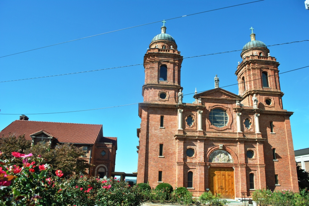
Basilica of St. Lawrence, Asheville
Monument and historic site · National Register of Historic Places · 3.8 mi
Minor basilica of the Roman Catholic Church in Asheville, North Carolina

Battery Park Hotel
Monument and historic site · National Register of Historic Places · 4.4 mi
Hotel in North Carolina, United States of America
Bledsoe Building
Monument and historic site · National Register of Historic Places · 4.7 mi
Historic building in North Carolina, US
Broadway Market Building
Monument and historic site · National Register of Historic Places · 3.6 mi
Asheville, NC, listed on the NRHP in North Carolina

Building at 130–132 Biltmore Avenue
Monument and historic site · National Register of Historic Places · 4.4 mi
Historic building in Asheville, North Carolina, USA

Building at 134–136½ Biltmore Avenue
Monument and historic site · National Register of Historic Places · 4.4 mi
Historic building in Asheville, North Carolina, USA
Buncombe County Boys' Training School
Monument and historic site · National Register of Historic Places · 2.7 mi
Historic school building in North Carolina, United States


Buncombe County Courthouse
Monument and historic site · National Register of Historic Places · 4.1 mi
County courthouse in Asheville, United States of America
50 more on the map.
Parks, trails and playgrounds8

Botanical Gardens at Asheville
Park · 2.5 mi
A collection of various greenery that is found in North Carolina.
151 W.T. Weaver Boulevard, Asheville
sunrise-sunset


Restaurants and cafes47

Cecilia's Kitchen
Diner · American · 2.3 mi
870 Merrimon Ave.
Su 10:00-16:00; Tu-Sa 11:00-15:00, 17:00-20:30

Jeremiah’s Italian Ice
Ice cream · Ice Cream · 2.5 mi
Italian ice and soft-serve ice cream, drive-thru and walk-up with limited outdoor seating.
705 Merrimon Avenue
Su-Th 12:00-22:00; Fr-Sa 12:00-23:00


Joey's Bagels - Asheville
Restaurant · Bagel, Breakfast, Coffee Shop · 2.5 mi
707 Merrimon Avenue, Asheville
Mo-Sa 06:00-14:00; Su 07:00-14:00
Pelican's SnoBalls of Woodfin
Restaurant · Dessert, Snoballs, Shaved Ice · 0.7 mi
235 Weaverville Highway, Asheville
Mo-Sa 12:00-21:00; Su 13:00-21:00

Gravelo Workshop Bicycle & Coffee
Bar and pub · 2.3 mi
793 Merrimon Avenue, Asheville
Tu-Fr 10:00-18:00; Sa 09:00-16:00; Su "by appointment"
PennyCup Coffee
Cafe · Coffee Shop · 1.4 mi
1 Woodfin Avenue, Asheville
Mo-Sa 07:00-18:00; Su 07:00-15:00
Vinnie's
Restaurant · Italian · 2.5 mi
641 Merrimon Avenue, Asheville
Mo-Su 16:30-21:00; Fr,Sa 16:30-21:30
35 more on the map.
History
The town's history is closely tied to manufacturing. Much of the remaining early housing stock is characteristic of early 20th century mill villages. Many neighborhoods within the community bear names tied to the industry, such as "Martel Village" and "Company Bottom". The decline of American industry in the 1970s and '80s brought a decline to the economy of Woodfin as well. The loss of many manufacturing jobs led to a decline in population and property values. Starting in the 1990s, however, the town has experienced new residential growth, due primarily to the influx of new residents to western North Carolina. Woodfin's economy today is a mix of large- and small-scale manufacturing, combined with a variety of residential and commercial districts. It is the 115th largest municipality in the state.
North Carolina Electrical Power Company Electric Generating Plant was listed on the National Register of Historic Places in 1999.
From the History section of Woodfin, North Carolina on Wikipedia, under CC BY-SA 4.0.
Where to stay5
Days Inn by Wyndham Asheville Downtown North
Motel and hotel · 0.4 mi
3 Reynolds Mountain Boulevard, Asheville
Churches and places of worship25
St. Luke's Episcopal Church
Church · National Register of Historic Places · 4.4 mi
Weaverville United Methodist Church
Church · National Register of Historic Places · 3.9 mi
Shopping10
Gas and EV charging8
Schools, colleges and libraries34
Buncombe County Schools Virtual Academy
School · 5.8 mi
21 Trinity Chapel Rd, Asheville
Healthcare5
DaVita Weaverville Dialysis
Clinic and pharmacy · 2.3 mi
329 Merrimon Avenue, Weaverville
Map of Woodfin
215 places. The map loads OpenStreetMap tiles when you open it.
Climate by month
Monthly table
| Month | High | Low | Rain | Snow |
|---|---|---|---|---|
| Jan | 48°F | 29°F | 3.3 in | 3.8 in |
| Feb | 52°F | 32°F | 2.9 in | 2.2 in |
| Mar | 59°F | 38°F | 3.5 in | 2.0 in |
| Apr | 69°F | 46°F | 3.7 in | 0.3 in |
| May | 76°F | 54°F | 3.5 in | 0.0 in |
| Jun | 83°F | 61°F | 3.4 in | 0.0 in |
| Jul | 86°F | 65°F | 4.1 in | 0.0 in |
| Aug | 85°F | 64°F | 3.6 in | 0.0 in |
| Sep | 79°F | 58°F | 3.7 in | 0.0 in |
| Oct | 69°F | 47°F | 2.6 in | 0.0 in |
| Nov | 59°F | 37°F | 3.0 in | 0.5 in |
| Dec | 50°F | 32°F | 3.3 in | 2.7 in |
U.S. Climate Normals 1991-2020 for Asheville (4 mi away), NOAA NCEI.
People and cost of living
American Community Survey 5-year estimates, 2020-2024, U.S. Census Bureau. Estimates have margins of error, larger for small towns.
Disaster history
Buncombe County has had 16 federal disaster declarations since 2000, most often for hurricanes.
- 2026-01-24: Severe Winter Storm (Winter Storm)
- 2024-09-28: Tropical Storm Helene (Tropical Storm)
- 2024-09-26: Hurricane Helene (Tropical Storm)
- 2022-10-01: Hurricane Ian (Hurricane)
- 2021-09-08: Remnants Of Tropical Storm Fred (Hurricane)
- 2020-08-02: Hurricane Isaias (Hurricane)
OpenFEMA disaster declarations summaries.
Getting there and nearby towns
Barker Private STOL Airport (53NR) is the nearest airport with scheduled flights listed in OpenStreetMap, 4 miles away.
- Emma 3 mi south, about 5 min by car
- Weaverville 4 mi northeast, about 6 min by car
- Asheville 6 mi south, about 9 min by car
- Biltmore Forest 8 mi south, about 13 min by car
- Bent Creek 10 mi south, about 15 min by car
- Swannanoa 12 mi east, about 19 min by car
- Royal Pines 13 mi south, about 20 min by car
- Avery Creek 13 mi south, about 20 min by car
- Mars Hill 13 mi north, about 20 min by car
- Fairview 13 mi southeast, about 22 min by car
Drive times are estimates from straight-line distance, not routes.
Local news
Headlines from INDB, the NEMICO news database.
Reviews, tips and questions
Loading what members have shared...
Sources and licences
- NCES EDGE (Public domain): public schools
- NOAA NCEI U.S. Climate Normals 1991-2020 (Public domain): climate by month
- OpenFEMA (Public domain): disaster declarations
- OpenStreetMap contributors (ODbL 1.0): places, airports, map data
- U.S. Census Bureau (Public domain): population, income, housing, education, commute
- Wikidata (CC0 1.0): elevation, founding date, time zone, website, landmarks and historic places
- Wikimedia Commons (see each image): photos
- Wikipedia (CC BY-SA 4.0): overview and history text
Photo credits
- Grove Park Historic District - Dr. Louie Mueller Griffith House, Upstateherd, CC BY-SA 4.0
- Seven Oaks - Asheville, NC, Upstateherd, CC BY-SA 4.0
- Saint Luke's Episcopal Church, Asheville, North Carolina, USA, Suzanne Tourtillott, CC BY-SA 3.0
- Sawyer Motor Company Building, 2013, Elisa.rolle, CC BY-SA 4.0
- 130 Biltmore Ave, Jhersk, CC BY-SA 3.0
- Demens House, Bill Fitzpatrick, CC BY-SA 3.0
- Thomas Wolfe's Home, Abe Ezekowitz, CC BY-SA 2.0
- Buncombe County Courthouse, Teemu08, CC BY-SA 3.0
- Clingmon Avenue Historic District Wide, Bill Fitzpatrick, CC BY-SA 3.0
- Jarrett 1, Daigle3541, CC BY-SA 3.0
- Ravenscroft School, Bill Fitzpatrick, CC BY-SA 3.0
- Asheville City Hall - Asheville, NC, Upstateherd, CC BY-SA 4.0
- Whitford G. Smith House 02, Elisa.rolle, CC BY-SA 4.0
- Building at 134-136½ Biltmore Avenue, Farragutful, CC BY-SA 3.0
- Dr. Carl V. Reynolds House, Upstateherd, CC BY-SA 4.0
- Battery Park Hotel, Teemu08, CC BY-SA 3.0
- Young Mens Institute Building 02, Karen D. Hoffman, CC BY-SA 3.0
- Approach to Grove Park Inn, Southern Post Card Co., Asheville, North Carolina (publisher), Public domain
- Edgemont Road, Proximity Park, Nyttend, Public domain
- Asheville Transfer and Storage Company Building 192 Coxe Ave, Renard DellaFave, CC BY-SA 3.0
- First Baptist Church Asheville, Bill Fitzpatrick, CC BY-SA 3.0
- William Jennings Bryan House 02, Karen D. Hoffman, CC BY-SA 3.0
- Overlook Castle in 1920, Unknown author Unknown author, Public domain
- Richard Sharp Smith House 02, Karen D. Hoffman, CC BY-SA 3.0
- Chestnut Historic District, Jhersk, CC BY-SA 3.0
- St. Matthias Episcopal Church (Asheville, North Carolina), Farragutful, CC BY-SA 3.0
- Dining Lodge, 1937, Upstateherd, CC BY-SA 4.0
- Basilica of St. Lawrence, Asheville (1), Elisa.rolle, CC BY-SA 4.0
- S&W Cafeteria Building, Asheville, NC (45827769765), Warren LeMay from Cincinnati, OH, United States, CC0
- Mrs Minnie Alexander Cottage, Bill Fitzpatrick, CC BY-SA 3.0
- Homewood School Building, Zillicoa St., Montford Area, Karen D. Hoffman, CC BY-SA 3.0
- North Carolina Electrical Power Company Electric Generating Plant, Upstateherd, CC BY-SA 4.0
- Saint Marys Episcopal Church, Bill Fitzpatrick, CC BY-SA 3.0
- Weaverville United Methodist Church, Swright618, CC BY-SA 3.0
- Douglas Ellington House, Asheville, NC 01, Karen Hoffman, CC BY-SA 3.0
- Riverside Industrial District, Bill Fitzpatrick, CC BY-SA 3.0
- Ottari Sanatarium, Bill Fitzpatrick, CC BY-SA 3.0
- Asheville Downtown panorama, AbeEzekowitz, CC BY-SA 3.0
- Richbourg Motors Building, Nicole Justiniano, CC BY-SA 3.0
- George A. Mears House, Farragutful, CC BY-SA 3.0


Page built October 30, 2026. Spotted a mistake? Tell us or suggest a place.