


Youngstown, New York
Youngstown is a village of 1,758 people in Niagara County, New York, founded in 1796.
Why visit Youngstown
Townapedia lists 14 museums and landmarks, 8 parks and trails, 2 places to stay and 5 attractions in and around town.
Highlights include Fort Niagara Light, Fort Niagara Lighthouse, Fort Niagara and John Carter Farmstead.
July is the warmest month, with average highs of 83°F; January lows average 19°F, and about 55 inches of snow fall in a normal year.
Weather in Youngstown
Forecast from the National Weather Service. Full forecast
About Youngstown
Youngstown is a village in Niagara County, New York, United States. As of the 2020 census, Youngstown had a population of 1,859. It is part of the Buffalo-Niagara Falls metropolitan area.
From the Wikipedia article Youngstown, New York (this version), under CC BY-SA 4.0.
Things to do5

Fort Niagara Light
Lighthouse · National Register of Historic Places · 1.4 mi
Lighthouse in New York, United States

Fort Niagara Lighthouse
Lighthouse · 1.3 mi
3 Scott Avenue, Youngstown


Museums and landmarks14

Fort Niagara
Monument and historic site · National Register of Historic Places · 1.4 mi
Fort

John Carter Farmstead
Monument and historic site · National Register of Historic Places · 1.0 mi
Historic house in New York, United States
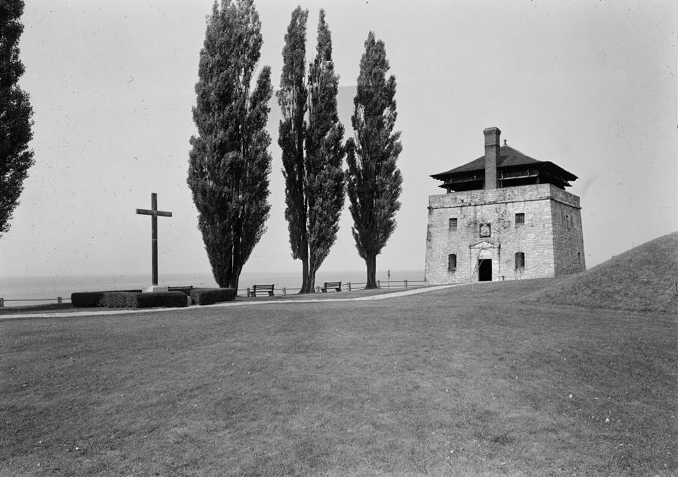


Father Millet Cross
Monument and historic site · 1.4 mi
Monument in New York, United States of America

2 more on the map.
Parks, trails and playgrounds8



Where to stay2

History
The village's early growth was under the protection of Fort Niagara.
The village was destroyed by the British in 1813 during the War of 1812.
The Village of Youngstown was incorporated in 1854, named after John Young.
Youngstown is an historic village located at the northwestern corner of the state where the Niagara River flows into Lake Ontario.
In an area known to the Indians for hundreds of years, the French explorer La Salle left his mark by building a small fort in 1670, less than a mile north of where the village now stands. The French gained control of the Great Lakes area and by 1727 built the "Castle" which became the centerpiece of Old Fort Niagara.
John Young, who lived across the river, saw opportunities on this side and built a store on the landing area in 1809. In 1811, he bought Lots 1 and 2 of the Mile Reserve. These included all the property from what is now the north side of Falkner Park and as far south as Campbell Street and from the river eastward to what is now the Niagara Scenic Parkway.
Young sold the Falkner Park area to Robert Greensit in March 1812 before the war started between the U.S. and England. By that time, a number of log cabins had been built to provide shelter for the skilled tradesmen and storekeepers who were attracted to the area by the Fort which needed many supplies and services.
From the History section of Youngstown, New York on Wikipedia, under CC BY-SA 4.0.
Churches and places of worship5
St. John's Episcopal Church
Church · National Register of Historic Places · 0.5 mi
Gas and EV charging1
Schools, colleges and libraries5
Map of Youngstown
40 places. The map loads OpenStreetMap tiles when you open it.
Climate by month
Monthly table
| Month | High | Low | Rain | Snow |
|---|---|---|---|---|
| Jan | 34°F | 19°F | 2.4 in | 12.8 in |
| Feb | 36°F | 19°F | 2.2 in | 20.8 in |
| Mar | 43°F | 25°F | 2.7 in | 8.1 in |
| Apr | 55°F | 35°F | 4.1 in | 1.7 in |
| May | 68°F | 46°F | 2.9 in | 0.0 in |
| Jun | 77°F | 57°F | 3.2 in | 0.0 in |
| Jul | 83°F | 62°F | 3.2 in | 0.0 in |
| Aug | 81°F | 61°F | 2.2 in | 0.0 in |
| Sep | 74°F | 54°F | 3.2 in | 0.0 in |
| Oct | 62°F | 44°F | 2.9 in | 0.0 in |
| Nov | 50°F | 34°F | 2.7 in | 2.0 in |
| Dec | 38°F | 26°F | 2.7 in | 9.8 in |
U.S. Climate Normals 1991-2020 for Youngstown 2 E (2 mi away), NOAA NCEI.
People and cost of living
American Community Survey 5-year estimates, 2020-2024, U.S. Census Bureau. Estimates have margins of error, larger for small towns.
Disaster history
Niagara County has had 19 federal disaster declarations since 2000, most often for severe storms.
- 2023-03-15: Severe Winter Storm And Snowstorm (Snowstorm)
- 2022-11-20: Severe Winter Storm And Snowstorm (Winter Storm)
- 2020-03-20: Covid-19 Pandemic (Biological)
- 2020-03-13: Covid-19 (Biological)
- 2017-11-14: Flooding (Flood)
- 2013-07-12: Severe Storms And Flooding (Flood)
OpenFEMA disaster declarations summaries.
Getting there and nearby towns
Niagara Falls International Airport (IAG) is the nearest airport with scheduled flights listed in OpenStreetMap, 11 miles away.
- Ransomville 7 mi east, about 11 min by car
- Niagara Falls 11 mi south, about 18 min by car
- Sanborn 11 mi southeast, about 18 min by car
- Wilson 12 mi northeast, about 19 min by car
- North Tonawanda 16 mi southeast, about 26 min by car
- Lockport 18 mi east, about 29 min by car
- Tonawanda 18 mi southeast, about 29 min by car
- Tonawanda Town 20 mi southeast, about 32 min by car
- Kenmore 21 mi southeast, about 35 min by car
- Buffalo 26 mi south, about 42 min by car
Drive times are estimates from straight-line distance, not routes.
Local news
Headlines from INDB, the NEMICO news database.
Reviews, tips and questions
Loading what members have shared...
Sources and licences
- NCES EDGE (Public domain): public schools
- NOAA NCEI U.S. Climate Normals 1991-2020 (Public domain): climate by month
- OpenFEMA (Public domain): disaster declarations
- OpenStreetMap contributors (ODbL 1.0): places, airports, map data
- U.S. Census Bureau (Public domain): population, income, housing, education, commute
- Wikidata (CC0 1.0): elevation, founding date, time zone, website, landmarks and historic places
- Wikimedia Commons (see each image): photos
- Wikipedia (CC BY-SA 4.0): overview and history text
Photo credits
- 52 St John's Episcopal Church 1, Florence88, CC BY-SA 3.0
- St. John Lutheran Church, Youngstown, New York - 20230128, Andre Carrotflower, CC BY-SA 4.0
- Niagara River, Youngstown, New York (7992645479), Ken Lund from Reno, Nevada, USA, CC BY-SA 2.0
- Niagara River, Youngstown, New York (7992643303), Ken Lund from Reno, Nevada, USA, CC BY-SA 2.0
- Youngstown, New York - 6197208197, Dougtone, CC BY-SA 2.0
- Youngstown, New York - 6197208619, Dougtone, CC BY-SA 2.0
- Youngstown, New York - 6197209527, Dougtone, CC BY-SA 2.0
- Youngstown, New York - 6197211067, Dougtone, CC BY-SA 2.0
- Youngstown, New York - 6197209333, Dougtone, CC BY-SA 2.0
- Youngstown, New York - 6197730048, Dougtone, CC BY-SA 2.0
- Youngstown, New York - 6197211251, Dougtone, CC BY-SA 2.0
- Youngstown, New York - 6197211777, Dougtone, CC BY-SA 2.0
- Youngstown, New York - 6197210617, Dougtone, CC BY-SA 2.0
- Youngstown, New York - 6197729460, Dougtone, CC BY-SA 2.0
- Youngstown, New York - 6197728266, Dougtone, CC BY-SA 2.0
- Youngstown, New York - 6197209655, Dougtone, CC BY-SA 2.0
- Youngstown, New York - 6197725590, Dougtone, CC BY-SA 2.0
- Youngstown, New York - 6197728902, Dougtone, CC BY-SA 2.0
- Youngstown, New York - 6197209181, Dougtone, CC BY-SA 2.0
- Youngstown, New York - 6197211863, Dougtone, CC BY-SA 2.0
- Youngstown, New York - 6197725882, Dougtone, CC BY-SA 2.0
- Youngstown, New York - 6197210993, Dougtone, CC BY-SA 2.0
- Youngstown, New York - 6197208835, Dougtone, CC BY-SA 2.0
- Youngstown, New York, Dougtone, CC BY-SA 2.0
- Youngstown, New York - 6197209011, Dougtone, CC BY-SA 2.0
- Youngstown, New York - 6197728580, Dougtone, CC BY-SA 2.0
- Youngstown, New York - 6197726352, Dougtone, CC BY-SA 2.0
- Youngstown, New York - 6197207667, Dougtone, CC BY-SA 2.0
- Youngstown, New York - 6197730612, Dougtone, CC BY-SA 2.0
- Youngstown, New York - 6197211427, Dougtone, CC BY-SA 2.0
- Youngstown, New York - 6197726020, Dougtone, CC BY-SA 2.0
- Youngstown, New York - 6197211591, Dougtone, CC BY-SA 2.0
- Youngstown, New York - 6197211499, Dougtone, CC BY-SA 2.0
- Youngstown, New York - 6197212247, Dougtone, CC BY-SA 2.0
- Youngstown, New York - 6197209817, Dougtone, CC BY-SA 2.0
- John Carter Farmstead Jun 09, Pubdog at English Wikipedia, Public domain
- St Johns Episcopal Church Jun 09, Pubdog ( talk ), Public domain
- French castle at Fort Niagara 2, Ad Meskens, CC BY-SA 3.0
- 22 Fort Niagara Light 1, Florence88, CC BY-SA 3.0
- Father-Millet-Cross-01, J. Carl Burke, Jr., Public domain


Page built October 30, 2026. Spotted a mistake? Tell us or suggest a place.