


Avenel, New Jersey
Avenel is a community of 17,121 people in Middlesex County, New Jersey.
Why visit Avenel
Townapedia lists 6 museums and landmarks, 30 parks and trails, 48 places to eat, 15 places to stay and 2 attractions in and around town.
Highlights include Union County Performing Arts Center, Rahway River Bridge, Barron Library and Merchants and Drovers Tavern.
July is the warmest month, with average highs of 86°F; January lows average 25°F, and about 26 inches of snow fall in a normal year.
Weather in Avenel
Forecast from the National Weather Service. Full forecast
About Avenel
Avenel () is an unincorporated community and census-designated place (CDP) located within Woodbridge Township, in Middlesex County, in the U.S. state of New Jersey. Avenel is approximately 25 miles (40 km) southwest of Midtown Manhattan along the North Jersey Coast rail line.
From the Wikipedia article Avenel, New Jersey (this version), under CC BY-SA 4.0.
Things to do2

Union County Performing Arts Center
Cinema and theater · National Register of Historic Places · 1.8 mi
Theater and former movie theater in Rahway, New Jersey, United States

Rahway River Bridge
Bridge · 1.7 mi
Bridge in Union County, New Jersey
Museums and landmarks6

Barron Library
Monument and historic site · National Register of Historic Places · 1.6 mi
Historic building in Woodbridge, New Jersey

Merchants and Drovers Tavern
Monument and historic site · National Register of Historic Places · 2.3 mi
Historic building in Union County, New Jersey

Robinson Plantation House
Monument and historic site · National Register of Historic Places · 2.9 mi
Historic house in New Jersey, United States
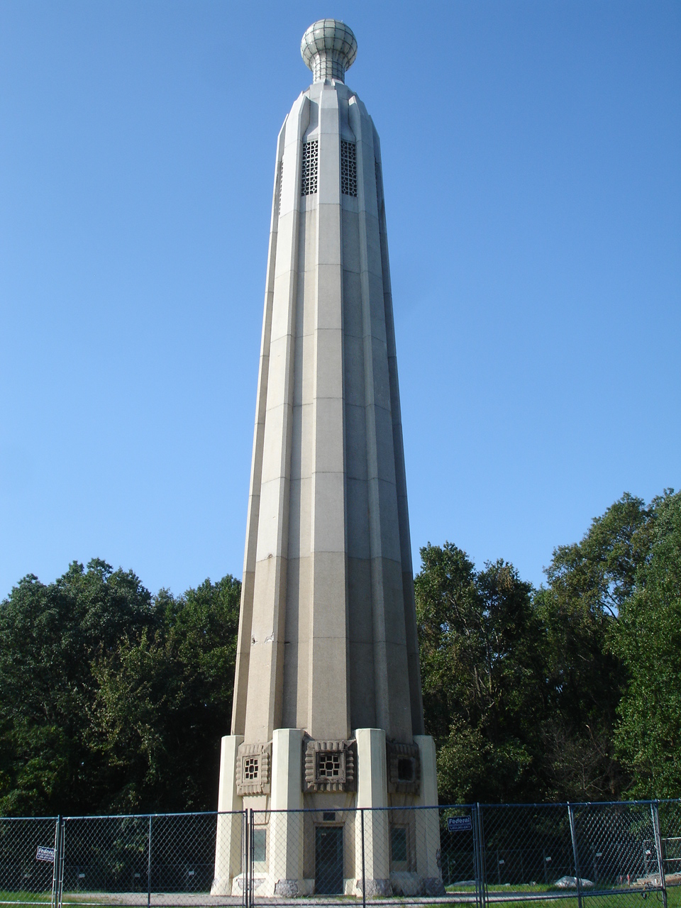
Thomas Alva Edison Memorial Tower and Museum
Museum · National Register of Historic Places · 3.9 mi

Barron Arts Center
Museum · 1.6 mi
582 Rahway Avenue, Woodbridge

Parks, trails and playgrounds30




18 more on the map.
Restaurants and cafes48


Copacabana Coffee & Bagles
Cafe · Bagel, Coffee Shop · 1.5 mi
77 East Milton Avenue, Rahway
Mo-Fr 06:00-16:00; Sa-Su 07:00-16:00
CubaNu Restaurant & Lounge
Restaurant · Cuban · 1.5 mi
1467 Main Street, Rahway
Su,Mo 14:00-22:00, Tu,We 11:00-23:30, Th 11:00-24:00, Fr...
Luciano's Ristorante
Restaurant · Italian, American · 1.7 mi
1579 Main Street, Rahway
We,Th 15:30-21:00; Fr 11:30-22:00; Sa 15:30-22:00; Su 15:30-21:00;...
Michelino's Pizzaria
Restaurant · Pizza · 1.5 mi
79 East Milton Avenue, Rahway
Mo-Th 10:00-22:00; Fr-Sa 10:00-23:00; Su 11:00-22:00
Mulberry Street Restaurant
Restaurant · Italian · 1.2 mi
739 Rahway Avenue, Woodbridge
Mo off; Tu-Th 11:30-22:00; Fr 11:30-23:00; Sa 16:00-23:00; Su 15:00-21:00
Nancy's Townehouse
Restaurant · Italian, Pizza · 1.5 mi
1453 Main Street, Rahway
Tu-Th 12:00-21:00; Fr 12:00-22:00; Sa 16:00-22:00; Su 16:00-21:00;...

Perkins
Diner · American · 1.4 mi
1009 Saint Georges Avenue, Colonia
Su 08:00-17:00; Mo-Th 09:00-18:00; Fr-Sa 08:00-18:00
il a forno a legna
Restaurant · Pizza, Italian · 1.5 mi
1464 Main Street, Rahway
Mo-Tu 11:00-21:00; We-Sa 11:00-22:00; Su 11:00-21:00

Flynn's Pub House
Bar and pub · 1.5 mi
1482 Main Street, Rahway
Mo closed; Tu-Th 16:00-24:00; Fr-Sa 11:00-25:00, Su 09:00-20:00
The Waiting Room
Restaurant · 1.6 mi
66 East Cherry Street, Rahway
Mo-Th 11:00-24:00; Fr 11:00-25:00, Sa 11:00-26:00; Su 11:00-24:00
36 more on the map.
History
The community was established in 1901; it was named for the daughter of Captain Demarest, the founder of the village, which had formerly been known as Demarest on the Hill. Besides the Demarests, the first settlers included members of the Brown, Clark, Cooper, Crowell, Douglass, Edgar, and Thorpe families.
From the History section of Avenel, New Jersey on Wikipedia, under CC BY-SA 4.0.
Where to stay15
Churches and places of worship18
Trinity Episcopal Church
Church · National Register of Historic Places · 1.6 mi
650 Rahway Avenue, Woodbridge
First Presbyterian Church
Church · National Register of Historic Places · 1.6 mi
Saint Anthony of Padua Roman Catholic Church
Church · Catholic · 1.6 mi
436 Port Reading Avenue, Port Reading
Second Presbyterian Church
Church · Presbyterian · 1.3 mi
1221 New Brunswick Avenue, Rahway
Shopping4
Gas and EV charging16
Schools, colleges and libraries56
Academy For Urban Leadership Charter School
School · 4.4 mi
612 Amboy Ave, Perth Amboy
Healthcare3
Map of Avenel
198 places. The map loads OpenStreetMap tiles when you open it.
Climate by month
Monthly table
| Month | High | Low | Rain | Snow |
|---|---|---|---|---|
| Jan | 40°F | 25°F | 3.7 in | 7.0 in |
| Feb | 43°F | 27°F | 3.3 in | 8.2 in |
| Mar | 51°F | 33°F | 4.4 in | 5.0 in |
| Apr | 62°F | 43°F | 4.0 in | 0.3 in |
| May | 72°F | 52°F | 4.2 in | 0.0 in |
| Jun | 81°F | 62°F | 4.5 in | 0.0 in |
| Jul | 86°F | 68°F | 5.3 in | 0.0 in |
| Aug | 84°F | 66°F | 4.1 in | 0.0 in |
| Sep | 77°F | 59°F | 4.2 in | 0.0 in |
| Oct | 66°F | 47°F | 4.4 in | 0.0 in |
| Nov | 55°F | 38°F | 3.6 in | 0.1 in |
| Dec | 45°F | 30°F | 4.5 in | 5.7 in |
U.S. Climate Normals 1991-2020 for Cranford (6 mi away), NOAA NCEI.
People and cost of living
American Community Survey 5-year estimates, 2020-2024, U.S. Census Bureau. Estimates have margins of error, larger for small towns.
Disaster history
Middlesex County has had 17 federal disaster declarations since 2000, most often for hurricanes.
- 2021-09-05: Remnants Of Hurricane Ida (Hurricane)
- 2021-09-02: Remnants Of Hurricane Ida (Hurricane)
- 2020-03-25: Covid-19 Pandemic (Biological)
- 2020-03-13: Covid-19 (Biological)
- 2016-03-14: Severe Winter Storm And Snowstorm (Severe Storm)
- 2012-10-30: Hurricane Sandy (Hurricane)
OpenFEMA disaster declarations summaries.
Getting there and nearby towns
Linden Airport (LDJ) is the nearest airport with scheduled flights listed in OpenStreetMap, 2 miles away.
- Fords 4 mi southwest, about 6 min by car
- Metuchen 6 mi southwest, about 9 min by car
- Roselle Park 6 mi north, about 9 min by car
- Elizabeth 7 mi northeast, about 11 min by car
- Highland Park 10 mi southwest, about 16 min by car
- Newark 11 mi northeast, about 18 min by car
- New Providence 11 mi northwest, about 17 min by car
- Short Hills 11 mi north, about 18 min by car
- Middlesex 12 mi west, about 19 min by car
- Jersey City 14 mi northeast, about 22 min by car
Drive times are estimates from straight-line distance, not routes.
Local news
Headlines from INDB, the NEMICO news database.
Reviews, tips and questions
Loading what members have shared...
Sources and licences
- NCES EDGE (Public domain): public schools
- NOAA NCEI U.S. Climate Normals 1991-2020 (Public domain): climate by month
- OpenFEMA (Public domain): disaster declarations
- OpenStreetMap contributors (ODbL 1.0): places, airports, map data
- U.S. Census Bureau (Public domain): population, income, housing, education, commute
- Wikidata (CC0 1.0): elevation, founding date, time zone, website, landmarks and historic places
- Wikimedia Commons (see each image): photos
- Wikipedia (CC BY-SA 4.0): overview and history text
Photo credits
- Avenel station at night showing short platform, Jonathan Schilling, CC BY-SA 4.0
- CR 514 eb at Middlesex CR 650, Avenel, NJ, Nov. 2025, Mr. Matté (if there is an issue with this image, contact me using this image's Commons talk page , my Commons user talk page , or my English Wikipedia user talk page ; I'll know about it a lot faster), CC BY-SA 4.0
- 2016-03-12 15 24 30 Reassurance signs along northbound U.S. Route 1 and U.S. Route 9 (U.S. Route 1&9) at Avenel Avenue in Woodbridge, New Jersey, Famartin, CC BY-SA 4.0
- 2016-03-12 15 26 02 View west along Avenel Avenue (Middlesex County Route 650) at U.S. Route 1 and U.S. Route 9 (U.S. Route 1&9) in Woodbridge, New Jersey, Famartin, CC BY-SA 4.0
- 2018-05-18 15 18 34 View north along U.S. Routes 1 and 9 at Avenel Street (Middlesex County Route 650) in Woodbridge Township, Middlesex County, New Jersey, Famartin, CC BY-SA 4.0
- 2016-03-12 15 24 38 View north along U.S. Route 1 and U.S. Route 9 (U.S. Route 1&9) at Avenel Avenue in Woodbridge, New Jersey, Famartin, CC BY-SA 4.0
- Kmart Avenel - Final day 26, Curlyrnd, CC BY-SA 4.0
- Kmart Avenel - Final day 32, Curlyrnd, CC BY-SA 4.0
- Kmart Avenel - Final day 29, Curlyrnd, CC BY-SA 4.0
- Kmart Avenel - Final day 21, Curlyrnd, CC BY-SA 4.0
- Kmart Avenel - Final day 23, Curlyrnd, CC BY-SA 4.0
- Kmart Avenel - Final day 28, Curlyrnd, CC BY-SA 4.0
- Kmart Avenel - Final day 24, Curlyrnd, CC BY-SA 4.0
- Kmart Avenel - Final day 25, Curlyrnd, CC BY-SA 4.0
- Kmart Avenel - Final day 22, Curlyrnd, CC BY-SA 4.0
- Kmart Avenel - Final day 34, Curlyrnd, CC BY-SA 4.0
- Kmart Avenel - Final day 27, Curlyrnd, CC BY-SA 4.0
- Kmart Avenel - Final day 30, Curlyrnd, CC BY-SA 4.0
- Kmart Avenel - Final day 33, Curlyrnd, CC BY-SA 4.0
- Kmart Avenel - Final day 31, Curlyrnd, CC BY-SA 4.0
- Kmart Avenel - Final day 62, Curlyrnd, CC BY-SA 4.0
- Kmart Avenel - Final day 68, Curlyrnd, CC BY-SA 4.0
- Kmart Avenel - Final day 69, Curlyrnd, CC BY-SA 4.0
- Kmart Avenel - Final day 70, Curlyrnd, CC BY-SA 4.0
- Kmart Avenel - Final day 41, Curlyrnd, CC BY-SA 4.0
- Kmart Avenel - Final day 40, Curlyrnd, CC BY-SA 4.0
- Rahway theatre, PeterMac13, CC BY-SA 3.0
- Trinity Episcopal Church, Woodbridge, NJ - south west view, Zeete, CC BY-SA 4.0
- WilliamRobinsonPlantationHouse, KForce at en.wikipedia, CC BY-SA 3.0
- First Presbyterian Church of Woodbridge, Perrycart, CC BY-SA 3.0
- MerchantsAndDrovers, KForce at en.wikipedia, CC BY-SA 3.0
- Barron Arts Center-Barron Library, Perrycart, CC BY-SA 3.0
- TheEdisonTower, KForce at en.wikipedia, CC BY-SA 3.0
- 2018-05-20 18 11 42 View west along Middlesex County Route 514 (Rahway Avenue) between Randolph Avenue and Paddock Street in Woodbridge Township, Middlesex County, New Jersey, Famartin, CC BY-SA 4.0
- Cafe display, Shakher59, CC BY-SA 4.0
- 2018-05-18 15 25 24 View south along U.S. Routes 1 and 9 at Scarpelli Way in Woodbridge Township, Middlesex County, New Jersey, Famartin, CC BY-SA 4.0
- 2025-02-24 15 09 39 The Terminal Doppler Weather Radar for Newark Liberty International Airport (TEWR) in Woodbridge Township, Middlesex County, New Jersey, Famartin, CC BY-SA 4.0
- 2025-02-24 15 11 04 The Terminal Doppler Weather Radar for Newark Liberty International Airport (TEWR) in Woodbridge Township, Middlesex County, New Jersey, Famartin, CC BY-SA 4.0
- 2025-02-24 15 11 50 The Terminal Doppler Weather Radar for Newark Liberty International Airport (TEWR) in Woodbridge Township, Middlesex County, New Jersey, Famartin, CC BY-SA 4.0
- 2025-02-24 15 13 20 The Terminal Doppler Weather Radar for Newark Liberty International Airport (TEWR) in Woodbridge Township, Middlesex County, New Jersey, Famartin, CC BY-SA 4.0


Page built October 30, 2026. Spotted a mistake? Tell us or suggest a place.