


Short Hills, New Jersey
Short Hills is a community of 14,923 people in Essex County, New Jersey.
Why visit Short Hills
Townapedia lists 18 museums and landmarks, 23 parks and trails, 81 places to eat, 2 places to stay and 8 attractions in and around town.
Highlights include Paper Mill Playhouse;Papermill Playhouse, Paper Mill Playhouse, Reeves-Reed Arboretum and Baltusrol Golf Club.
July is the warmest month, with average highs of 86°F; January lows average 22°F, and about 24 inches of snow fall in a normal year.
Weather in Short Hills
Forecast from the National Weather Service. Full forecast
About Short Hills
Short Hills is an unincorporated community and census-designated place (CDP) situated within Millburn, in Essex County, within the U.S. state of New Jersey, and part of the New York metropolitan area. The community is a commuter town for residents who work in Manhattan. As of the 2020 census, the CDP's population was 14,422.
From the Wikipedia article Short Hills, New Jersey (this version), under CC BY-SA 4.0.
Things to do8

Paper Mill Playhouse
Cinema and theater · 1.2 mi
Theater in Millburn, New Jersey


Museums and landmarks18

Reeves-Reed Arboretum
Monument and historic site · National Register of Historic Places · 1.4 mi
Arboretum and garden in Summit, New Jersey, United States

Baltusrol Golf Club
Monument and historic site · National Register of Historic Places · 2.4 mi
Golf course in New Jersey, USA

Caldwell Parsonage
Monument and historic site · National Register of Historic Places · 3.8 mi
Historic house in Union County, New Jersey

Dusenberry House
Monument and historic site · National Register of Historic Places · 2.7 mi
Historic house in New Jersey, United States

Eberhardt Hall, New Jersey Institute of Technology
Monument and historic site · National Register of Historic Places · 3.5 mi
Building in New Jersey, United States

Hutchings Homestead
Monument and historic site · National Register of Historic Places · 2.3 mi
Building in New Jersey, United States
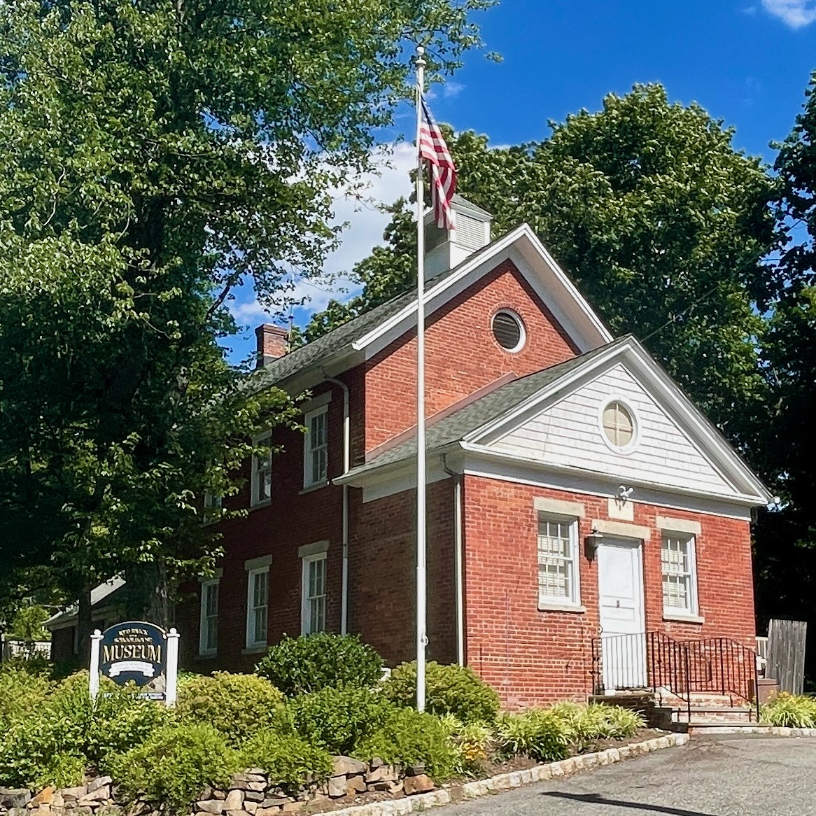
Mount Vernon School
Monument and historic site · National Register of Historic Places · 4.2 mi
Historic building in Morris County, New Jersey

Mountain Station
Monument and historic site · National Register of Historic Places · 4.0 mi
NJ Transit Rail station
Short Hills Park Historic District
Monument and historic site · National Register of Historic Places · 1.0 mi
Historic district in New Jersey, United States

South Orange
Monument and historic site · National Register of Historic Places · 3.5 mi
NJ Transit rail station

South Orange Fire House
Monument and historic site · National Register of Historic Places · 3.5 mi
Fire station in New Jersey, United States of America


Stone House by the Stone House Brook
Monument and historic site · National Register of Historic Places · 3.9 mi
Historic house in South Orange, New Jersey
6 more on the map.
Parks, trails and playgrounds23



11 more on the map.
Restaurants and cafes81


Pizza Vita
Restaurant · Pizza · 2.2 mi
Pizza Vita in Summit, NJ, serves award-winning Neapolitan pizza and authentic Italian dishes. Enjoy crispy wood-fired pizzas, pasta,...
7 Union Palace, Summit
Mo-Sa 11:30-20:30; Su 11:30-20:00

Gong Cha
Cafe · Bubble Tea · 1.5 mi
340 Millburn Avenue, Millburn
Su-Th 11:00-21:00; Fr-Sa 11:00-22:00
Starbucks
Cafe · Coffee Shop · 1.5 mi
343 Millburn Avenue, Millburn
Mo-Fr 05:30-20:00; Sa-Su 06:00-20:00


Kung Fu Tea
Cafe · Bubble Tea · 1.5 mi
315C Millburn Avenue, Millburn
11:00-19:00
69 more on the map.
Where to stay2
Churches and places of worship21
Springfield Presbyterian Church
Church · National Register of Historic Places · 2.1 mi
Wallace Chapel AME Zion Church
Church · National Register of Historic Places · 2.0 mi
Wallace Chapel African Methodist Episcopal Zion Church
Church · African Methodist Episcopal Zion · 1.9 mi
Saint Rose of Lima Church
Church · Roman Catholic · 1.3 mi
50 Short Hills Avenue, Short Hills
Shopping17
Gas and EV charging7
Schools, colleges and libraries59
Healthcare7
Map of Short Hills
243 places. The map loads OpenStreetMap tiles when you open it.
Climate by month
Monthly table
| Month | High | Low | Rain | Snow |
|---|---|---|---|---|
| Jan | 40°F | 22°F | 3.5 in | 5.8 in |
| Feb | 42°F | 23°F | 3.0 in | 8.4 in |
| Mar | 50°F | 31°F | 4.2 in | 4.6 in |
| Apr | 62°F | 40°F | 4.0 in | 0.4 in |
| May | 72°F | 50°F | 4.0 in | 0.0 in |
| Jun | 82°F | 60°F | 4.8 in | 0.0 in |
| Jul | 86°F | 66°F | 4.7 in | 0.0 in |
| Aug | 85°F | 64°F | 4.9 in | 0.0 in |
| Sep | 78°F | 56°F | 4.6 in | 0.0 in |
| Oct | 66°F | 44°F | 4.6 in | 0.0 in |
| Nov | 54°F | 35°F | 3.6 in | 0.7 in |
| Dec | 44°F | 28°F | 4.4 in | 4.1 in |
U.S. Climate Normals 1991-2020 for Canoe Brook (1 mi away), NOAA NCEI.
People and cost of living
American Community Survey 5-year estimates, 2020-2024, U.S. Census Bureau. Estimates have margins of error, larger for small towns.
Disaster history
Essex County has had 21 federal disaster declarations since 2000, most often for hurricanes.
- 2021-09-05: Remnants Of Hurricane Ida (Hurricane)
- 2021-09-02: Remnants Of Hurricane Ida (Hurricane)
- 2020-12-11: Tropical Storm Isaias (Hurricane)
- 2020-03-25: Covid-19 Pandemic (Biological)
- 2020-03-13: Covid-19 (Biological)
- 2018-06-08: Severe Winter Storm And Snowstorm (Severe Storm)
OpenFEMA disaster declarations summaries.
Getting there and nearby towns
Morristown Municipal Airport (MMU) is the nearest airport with scheduled flights listed in OpenStreetMap, 6 miles away.
- Florham Park 4 mi northwest, about 7 min by car
- New Providence 5 mi southwest, about 8 min by car
- Roselle Park 6 mi southeast, about 10 min by car
- Newark 8 mi east, about 13 min by car
- Elizabeth 9 mi southeast, about 14 min by car
- Lake Hiawatha 10 mi north, about 16 min by car
- Lincoln Park 13 mi north, about 21 min by car
- Jersey City 14 mi east, about 22 min by car
- Metuchen 14 mi south, about 22 min by car
- Paterson 15 mi northeast, about 24 min by car
Drive times are estimates from straight-line distance, not routes.
Local news
Headlines from INDB, the NEMICO news database.
Reviews, tips and questions
Loading what members have shared...
Sources and licences
- NCES EDGE (Public domain): public schools
- NOAA NCEI U.S. Climate Normals 1991-2020 (Public domain): climate by month
- OpenFEMA (Public domain): disaster declarations
- OpenStreetMap contributors (ODbL 1.0): places, airports, map data
- U.S. Census Bureau (Public domain): population, income, housing, education, commute
- Wikidata (CC0 1.0): elevation, founding date, time zone, website, landmarks and historic places
- Wikimedia Commons (see each image): photos
- Wikipedia (CC BY-SA 4.0): overview and history text
Photo credits
- Downtown Short Hills, NJ, Daniel Case, CC BY-SA 3.0
- Essex CR 608 nb at CR 606, Short Hills, NJ, Nov. 2025, Mr. Matté (if there is an issue with this image, contact me using this image's Commons talk page , my Commons user talk page , or my English Wikipedia user talk page ; I'll know about it a lot faster), CC BY-SA 4.0
- House on Old Short Hills Road (53524906637), Chris Rycroft from Madison, Wisconsin, United States, CC BY 2.0
- 2020-10-02 12 51 12 View north along Essex County Route 527 (Old Short Hills Road) at Essex County Route 606 (Parsonage Hill Road) in Millburn Township, Essex County, New Jersey, Famartin, CC BY-SA 4.0
- Cora Hartshorn arboretum in Short Hills, NJ September 2026 02, Stuttle2, CC BY 4.0
- Short Hills Sta jeh, Jim.henderson, Public domain
- Millstone at the Cora Hartshorn arboretum in Short Hills, NJ September 2026 01, Stuttle2, CC BY 4.0
- Visitors Center of the Cora Hartshorn arboretum in Short Hills, NJ September 2026 05, Stuttle2, CC BY 4.0
- Cora Hartshorn arboretum in Short Hills, NJ September 2026 03, Stuttle2, CC BY 4.0
- SHORT HILLS PARK HISTORIC DISTRICT, MILLBURN, ESSEX COUNTY, NJ, JERRYE & ROY KLOTZ, M.D., CC BY-SA 4.0
- Essex CR 608 nb at Hobart Road, Short Hills, NJ, Nov. 2025, Mr. Matté (if there is an issue with this image, contact me using this image's Commons talk page , my Commons user talk page , or my English Wikipedia user talk page ; I'll know about it a lot faster), CC BY-SA 4.0
- Summit NJ Unitarian Church, Tomwsulcer, CC0
- Reeves-Reed Arboretum, Daniel Case, CC BY-SA 3.0
- Wallace Chapel AME Zion Church, Daniel Case, CC BY-SA 3.0
- So Orange sta Sloan sunny jeh, Jim.henderson, CC0
- Eberhardt Hall NJIT jeh, Jim.henderson, Public domain
- Old Stone House South Orange NJ, Jared Kofsky/PlaceNJ.com, CC BY-SA 3.0
- Downtown Summit, NJ, The original uploader was Daniel Case at English Wikipedia ., CC BY-SA 3.0
- Ward Force House Livingston, Jared Kofsky/PlaceNJ.com, CC BY-SA 3.0
- Springfield, NJ, Presbyterian Church, Daniel Case, CC BY-SA 3.0
- Summit Playhouse jeh, Jim.henderson, Public domain
- Twin Maples, The original uploader was Daniel Case at English Wikipedia ., CC BY-SA 3.0
- Mount Vernon School, Chatham Township, NJ, Zeete, CC BY-SA 4.0
- Dusenberry House, Chatham, NJ, Daniel Case, CC BY-SA 3.0
- Caldwell Parsonage, Daniel Case, CC BY-SA 3.0
- Mountain Station - platform, Adam Moss, CC BY-SA 2.0
- So Orange Fire sta jeh, Jim.henderson, Public domain
- HutchingsHomesteadSpringfield, KForce at English Wikipedia, CC BY-SA 3.0
- So Orange Av tower jeh, Jim.henderson, Public domain
- Calvary Episcopal Church, Summit, New Jersey, Swimdb, CC BY-SA 4.0
- West Beechcroft Road (53526242330), Chris Rycroft from Madison, Wisconsin, United States, CC BY 2.0
- House on Montview Avenue (53526124089), Chris Rycroft from Madison, Wisconsin, United States, CC BY 2.0
- House on Jefferson Avenue (53524906547), Chris Rycroft from Madison, Wisconsin, United States, CC BY 2.0
- House on Jefferson Avenue (53524906382), Chris Rycroft from Madison, Wisconsin, United States, CC BY 2.0
- House on Beechcroft Road (53525982743), Chris Rycroft from Madison, Wisconsin, United States, CC BY 2.0
- Essex, NJ CR 649 sb at CR 606, Oct. 2026, Mr. Matté (if there is an issue with this image, contact me using this image's Commons talk page , my Commons user talk page , or my English Wikipedia user talk page ; I'll know about it a lot faster), CC BY-SA 4.0
- House on Montview Avenue (53526241620), Chris Rycroft from Madison, Wisconsin, United States, CC BY 2.0
- House on Wyndham Road (53524906202), Chris Rycroft from Madison, Wisconsin, United States, CC BY 2.0
- Glenwood School Millburn jeh, Jim.henderson, CC0
- 20190403 105458 Burst01 (2), Ekem, CC BY-SA 4.0


Page built October 30, 2026. Spotted a mistake? Tell us or suggest a place.