
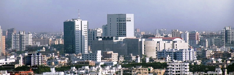


Dhaka, Bangladesh
ঢাকা
Dhaka is a capital city of 10,356,500 people in Dhaka Division, Bangladesh.
Why visit Dhaka
Townapedia lists 26 museums and landmarks, 19 parks and trails, 89 places to eat, 5 places to stay and 61 attractions in and around town.
Highlights include Ahsanullah University of Science and Technology, American International University-Bangladesh, Ahsan Manzil and Bangabandhu Memorial Museum.
Weather in Dhaka
Forecast from MET Norway (CC BY 4.0). Full forecast
About Dhaka
Dhaka ( DAH-kə or DAK-ə; Bengali: ঢাকা, romanized: Ḍhākā, pronounced [ˈɖʱaka] ), formerly spelled as Dacca, is the capital and largest city of Bangladesh. With an estimated population of 36.6 million, Dhaka is the second largest city by population in the world, and is widely considered to be the most densely populated built-up urban area in the world. Dhaka is an important cultural, economic, and scientific hub of Eastern South Asia. Dhaka ranks fourth in South Asia and 55th in the world in terms of GDP.
From the Wikipedia article Dhaka (this version), under CC BY-SA 4.0.
Travel tips from other travellers: Dhaka on Wikivoyage (CC BY-SA 4.0).
Things to do61

Ahsanullah University of Science and Technology
School · 5.9 km
Private university in Bangladesh

American International University-Bangladesh
School · 12.6 km
Private university in Bangladesh

ASA University Bangladesh
School · 8.2 km
Private university of Bangladesh

Asian University of Bangladesh
School · 17.7 km
Private university of Bangladesh

Atish Dipankar University of Science and Technology
School · 17.7 km
Private university of Bangladesh
Bangladesh College of Physicians and Surgeons
School · 7.5 km
College in Dhaka, Bangalaadesh
Bangladesh Islami University
School · 2.5 km
Private university in Dhaka, Bangladesh

Bangladesh Maritime University
School · 13.7 km
Public maritime university in Bangladesh

Bangladesh Medical University
School · 3.4 km
First public medical university in Bangladesh
Bangladesh University
School · 7.1 km
Private university of Bangladesh
Bangladesh University of Business and Technology
School · 12.1 km
Private university of Bangladesh

Bangladesh University of Engineering and Technology
School · 2.4 km
Public university in Dhaka, Bangladesh
49 more on the map.
Museums and landmarks26

Ahsan Manzil
Museum
জমিদার শেখ এনায়েতউল্লাহ প্রতিষ্ঠা করেন। পরবর্তীতে নবাব আবদুল গনি তার ছেলের নাম অনুসারে নামকরণ করেন।
Ahsanullah Road


Bangladesh Air Force Museum
Museum · 7.6 km
A Air Force museum of Bangladesh

Greek Memorial, Dhaka
Monument and historic site · 2.6 km
Monument in Dhaka, Bangladesh

Hussaini Dalan
Monument and historic site · 1.8 km
Muslim religious building

Khan Mohammad Mirdha Mosque
Monument and historic site · 2.5 km
Mosque in Bangladesh


Mausoleum of Kazi Nazrul Islam
Monument and historic site · 3.0 km
Resting place of the national poet of Bangladesh

Mausoleum of Three Leaders
Monument and historic site · 2.2 km
Mausoleum in Dhaka, Bangladesh

National Museum of Science and Technology
Museum · 8.4 km
Museum in Dhaka, Bangladeh


Shaheed Minar
Monument and historic site · 1.8 km
Monument to the deaths incurred in the Bangladesh for Language Movement in 1952
14 more on the map.
Parks, trails and playgrounds19


Ramna Park
Park · 3.2 km
Park and recreation area situated at Dhaka city




bir muktijpddha nur islam commander chotto
Park · 1.4 km
Zinzira - Ramerkanda Road, dhaka


7 more on the map.
Restaurants and cafes89



Al Razzak Restaurant
Restaurant · Bangladeshi · 0.9 km
29/1 North South Road, Bangshal, Dhaka
Mo-Su 06:00-24:00; PH closed
স্টার হোটেল এন্ড রেস্টুরেন্ট - জনসন রোড
Restaurant · Kebab, Chicken, Meat, Regional
Jonson Road
Mo-Su 07:00-23:00
Adi Moron Chand Ghosh and Sons Mistanno Vandar
Restaurant · 0.7 km
18 Nawabpur Rd
Mo-Su 08:00-22:00
Beauty Lacchi , Faluda & Kacchi Biriani
Restaurant · Regional · 1.3 km
2nd Brunch of Beauty Lacchi
Kazi Alauddin Road

77 more on the map.
Where to stay5
Churches and places of worship90
Tara Mosque
Place of worship · 0.8 km
Sharat Chandra Chakraborty Road
ambagicha jame mosjid
Place of worship · New Apostolic · 1.1 km
Kaligong Bazar Road, dhaka
Shopping216
NEWCOMEN BD
Hardware store · 0.8 km
Shop# 04, Block# D, Jabin Tower (Ground Floor), 234-235, 235 C, Nawabpur Road, Nawabpur, Dhaka-1100. Nawabpur Rd, Dhaka
Gas and EV charging3
S. Islam Trading G-Gas Showroom, Gas station, Lalmohan Saha Street, Dhaka
Gas station · 1.2 km
Schools, colleges and libraries61
K.L.Jubilee High School & College
School · 0.8 km
North Brook Hall Road, Dhaka
Healthcare72
Map of Dhaka
250 places. The map loads OpenStreetMap tiles when you open it.
Getting there and nearby towns
Hazrat Shahjalal International Airport (DAC) is the nearest airport with scheduled flights listed in OpenStreetMap, 15 km away.
- Motijheel 2 km northeast, about 2 min by car
- Paltan 3 km north, about 3 min by car
- Azimpur 3 km northwest, about 3 min by car
- Dukuria 3 km west, about 3 min by car
- Nawāb Char 4 km west, about 4 min by car
- Green Model Town 5 km northeast, about 5 min by car
- Mātuail 5 km east, about 5 min by car
- Kafrul 9 km north, about 9 min by car
- Gazipur 32 km north, about 32 min by car
- Agartala 90 km east, about 1 h 30 min by car
Drive times are estimates from straight-line distance, not routes.
Local news
Headlines from INDB.
Reviews, tips and questions
Loading what members have shared...
Sources and licences
- GeoNames (CC BY 4.0): population, coordinates, regions and time zone
- OpenStreetMap contributors (ODbL 1.0): places, airports, map data
- Wikidata (CC0 1.0): elevation, founding date, time zone, website, landmarks and historic places
- Wikimedia Commons (see each image): photos
- Wikipedia (CC BY-SA 4.0): overview and history text
Photo credits
- Dhaka skyline1, Tanweer drmc, Public domain
- Dhaka (49882939202), Francisco Anzola from United States, CC BY 2.0
- Old Dhaka Bangladesh - panoramio (2), Hiroki Ogawa, CC BY 3.0
- Rickshaw Parking at Dhaka (9601873282), Nasir Khan Saikat @ flickr from Dhaka, Bangladesh, CC BY-SA 2.0
- Girl on the phone, Dhaka (36212914350), Sudipta Arka Das from Dhaka, Bangladesh, CC BY-SA 2.0
- Shakharibazar dhaka 11 january 2019, Sudipta Arka Das, CC BY-SA 2.0
- Interior of Ahsan Manzil, Dhaka 44, Yahya, CC BY-SA 4.0
- Interior of Ahsan Manzil, Dhaka 43, Yahya, CC BY-SA 4.0
- Interior of Ahsan Manzil, Dhaka 91, Yahya, CC BY-SA 4.0
- Interior of Ahsan Manzil, Dhaka 92, Yahya, CC BY-SA 4.0
- Interior of Ahsan Manzil, Dhaka 84, Yahya, CC BY-SA 4.0
- Interior of Ahsan Manzil, Dhaka 85, Yahya, CC BY-SA 4.0
- Interior of Ahsan Manzil, Dhaka 86, Yahya, CC BY-SA 4.0
- Interior of Ahsan Manzil, Dhaka 18, Yahya, CC BY-SA 4.0
- Interior of Ahsan Manzil, Dhaka 51, Yahya, CC BY-SA 4.0
- Interior of Ahsan Manzil, Dhaka 48, Yahya, CC BY-SA 4.0
- Atish Dipankar University of Science and Technology, Mehediabedin, CC BY-SA 4.0
- BSMRMU, Ahamed Rafid, CC BY-SA 4.0
- Shahbag PG Hospital 2 by Ragib Hasan, Ragib Hasan / User:Ragib, CC BY 2.5
- ECE Building, BUET, Sajid Muhaimin Choudhury ( Smcbuet ), CC BY-SA 3.0
- Bangabandhu memorial museum front gate, Dhaka, Nurunnaby Chowdhury (Hasive), CC BY-SA 4.0
- Entry gate of Bangladesh Air Force Museum, Masum-al-hasan, CC BY-SA 4.0
- Greek Memorial - TSC Complex - University of Dhaka Campus - Dhaka 2015-05-31 2417, Biswarup Ganguly, CC BY 3.0
- হোসেনি দালান ২০১১ (১), Ronju65, CC BY-SA 4.0
- Khan Mohammad Mirdhas Mosque Dome by Ragib Hasan, Ragib Hasan / User:Ragib, CC BY 2.5
- Liberation War Museum,new building, Ahm masum, CC BY-SA 4.0
- Kazi Nazrul Islam Grave 1, Anik Sarker, CC BY-SA 4.0
- 3NM BD 11, Sume3349, CC BY-SA 4.0
- Bangladesh National Museum of Science and Technology Entrance, PeRshGo, CC BY-SA 4.0
- Sat Gambuj Mosque, Dhaka, Asif Ahmed Mazumder, CC BY-SA 4.0
- Shaheed Minar, Mostaque Ahammed, CC BY-SA 2.0
- Khawja Hafijullah Obelisk at Bahadur Shah Park 004, Rashed Ali, CC BY-SA 3.0
- Mirpur national zoo, Sojol Rana, CC BY-SA 4.0
- Teak trees in Ramna Park, Salim_Khandoker, CC0
- Chandrima Uddan (06), Nahid Sultan, CC BY-SA 3.0
- Armenian Church in Old Dhaka, No machine-readable author provided. Mak assumed (based on copyright claims)., CC BY-SA 3.0
- Archbishop's House, Kakrail, Dhaka 3, Ifteebd10, CC BY-SA 4.0
- Holy Rosary's Church, Hameem Shakhawat, CC BY-SA 3.0
- Dhaka, Catholic Cathedral of the Immaculate Conception, Grentidez, CC BY-SA 3.0
- St Thomas's Church, Dhaka (1904), Fritz Kapp, Public domain
- Pogose School 002, Rashed Ali, CC BY-SA 3.0
- Front facade of the Chawkbazar Mosque, Muyeedkhan69, CC BY-SA 3.0
- Binot Bibi mosque in Old Dhaka, No machine-readable author provided. Mak assumed (based on copyright claims)., CC BY-SA 3.0
- বলধা গার্ডেন, Reaz Uddin Rana, CC BY-SA 4.0
- Kabi Nazrul Govt College Dhaka Entrance, Mak, CC BY-SA 3.0
- St Gregory's School (Dhaka)007, Rashed Ali, CC BY-SA 3.0
- Beauty Boarding (05), Nidal Adnan, CC BY-SA 4.0
- Ahsan Manzil Museum, Dhaka, Bangladesh, Tanvir Rahat, CC BY-SA 4.0
- Star Mosque 2023, Dead.rabbit, CC BY-SA 4.0
- ASA University Bangladesh, Neilok, CC BY-SA 4.0
- Ahsanullah University of Science and Technology, Md Joni Hossain, CC BY-SA 4.0
- C Building, American International University of Bangladesh, Gary Todd, CC0


Page built November 4, 2026. Spotted a mistake? Tell us or suggest a place.