



Cascade-Chipita Park, Colorado
Cascade-Chipita Park is a community of 1,412 people in El Paso County, Colorado.
Why visit Cascade-Chipita Park
Townapedia lists 3 museums and landmarks, 2 parks and trails, 8 places to eat, 4 places to stay and 3 attractions in and around town.
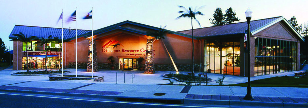
Highlights include Santa's Workshop, Eastholme and Rocky Mountain Dinosaur Resource Center.
July is the warmest month, with average highs of 74°F; January lows average 13°F, and about 134 inches of snow fall in a normal year.
Weather in Cascade-Chipita Park
Forecast from the National Weather Service. Full forecast
About Cascade-Chipita Park
Cascade-Chipita Park is a census-designated place (CDP) comprising the unincorporated communities of Cascade and Chipita Park located in, and governed by, El Paso County, Colorado, United States. The population of the Cascade-Chipita Park CDP was 1,628 at the United States Census 2020. The CDP is a part of the Colorado Springs, CO Metropolitan Statistical Area and the Front Range Urban Corridor. The Cascade, Colorado, post office (Zip Code 80809) serves the area.
From the Wikipedia article Cascade-Chipita Park, Colorado (this version), under CC BY-SA 4.0.
Things to do3


Museums and landmarks3


Eastholme
Monument and historic site · National Register of Historic Places · 3.5 mi
Place in Colorado listed on National Register of Historic Places
Rocky Mountain Dinosaur Resource Center
Museum · 4.6 mi
Museum in Woodland Park, Colorado

Parks, trails and playgrounds2


Restaurants and cafes8

The Pantry
Restaurant · American, Breakfast · 1.2 mi
6980 Lake Street, Green Mountain Falls
07:00-14:30


Blue Moose Tavern
Bar and pub · American · 1.2 mi
10530 Ute Pass Avenue, Green Mountain Falls
11:00+

History
The Cascade, Colorado, post office opened on August 16, 1887. The Chipita Park, Colorado, post office operated from March 9, 1935, until May 31, 1967, when it was merged into the Cascade post office
From the History section of Cascade-Chipita Park, Colorado on Wikipedia, under CC BY-SA 4.0.
Where to stay4
Shopping2
Gas and EV charging1
Schools, colleges and libraries6
Map of Cascade-Chipita Park
29 places. The map loads OpenStreetMap tiles when you open it.
Climate by month
Monthly table
| Month | High | Low | Rain | Snow |
|---|---|---|---|---|
| Jan | 39°F | 13°F | 0.7 in | 12.5 in |
| Feb | 39°F | 14°F | 1.0 in | 13.6 in |
| Mar | 45°F | 20°F | 1.9 in | 26.2 in |
| Apr | 50°F | 26°F | 3.1 in | 32.3 in |
| May | 59°F | 33°F | 2.5 in | 9.6 in |
| Jun | 70°F | 42°F | 2.1 in | 0.4 in |
| Jul | 74°F | 46°F | 3.9 in | 0.0 in |
| Aug | 72°F | 45°F | 3.9 in | 0.0 in |
| Sep | 66°F | 39°F | 1.9 in | 1.8 in |
| Oct | 56°F | 30°F | 1.2 in | 10.4 in |
| Nov | 46°F | 20°F | 0.8 in | 12.6 in |
| Dec | 39°F | 13°F | 0.8 in | 14.1 in |
U.S. Climate Normals 1991-2020 for Ruxton Park (7 mi away), NOAA NCEI.
People and cost of living
American Community Survey 5-year estimates, 2020-2024, U.S. Census Bureau. Estimates have margins of error, larger for small towns.
Disaster history
El Paso County has had 14 federal disaster declarations since 2000, most often for fires.
- 2023-08-25: Severe Storms, Flooding, And Tornadoes (Flood)
- 2020-03-28: Covid-19 Pandemic (Biological)
- 2020-03-13: Covid-19 (Biological)
- 2015-07-16: Severe Storms, Tornadoes, Flooding, Landslides, And Mudslides (Flood)
- 2013-09-14: Severe Storms, Flooding, Landslides, And Mudslides (Flood)
- 2013-09-12: Severe Storms, Flooding, Landslides, And Mudslides (Flood)
OpenFEMA disaster declarations summaries.
Getting there and nearby towns
United States Air Force Academy Airfield (AFF) is the nearest airport with scheduled flights listed in OpenStreetMap, 10 miles away.
- Woodland Park 5 mi northwest, about 8 min by car
- Manitou Springs 7 mi southeast, about 12 min by car
- Air Force Academy 8 mi northeast, about 13 min by car
- Gleneagle 11 mi northeast, about 18 min by car
- Monument 12 mi northeast, about 19 min by car
- Palmer Lake 13 mi north, about 20 min by car
- Colorado Springs 14 mi southeast, about 22 min by car
- Woodmoor 14 mi northeast, about 22 min by car
- Cimarron Hills 17 mi east, about 27 min by car
- Stratmoor 17 mi southeast, about 27 min by car
Drive times are estimates from straight-line distance, not routes.
Local news
Headlines from INDB, the NEMICO news database.
Reviews, tips and questions
Loading what members have shared...
Sources and licences
- NCES EDGE (Public domain): public schools
- NOAA NCEI U.S. Climate Normals 1991-2020 (Public domain): climate by month
- OpenFEMA (Public domain): disaster declarations
- OpenStreetMap contributors (ODbL 1.0): places, airports, map data
- U.S. Census Bureau (Public domain): population, income, housing, education, commute
- Wikidata (CC0 1.0): elevation, founding date, time zone, website, landmarks and historic places
- Wikimedia Commons (see each image): photos
- Wikipedia (CC BY-SA 4.0): overview and history text
Photo credits
- Eastholme Cascade CO 1998, Dennis Graham, CC BY-SA 3.0
- RMDRC Tight Cropped, MCDinosaurhunter, CC BY-SA 3.0
- Santas Workshop, Avrand6, CC BY-SA 4.0
- Three Window Deuce (28182443413), JOHN LLOYD from Concrete, Washington, United States, CC BY 2.0
- 1955 Ford Fairlane Victoria (29057078246), JOHN LLOYD from Concrete, Washington, United States, CC BY 2.0
- 1964 Oldsmobile F-85 (28253757322), JOHN LLOYD from Concrete, Washington, United States, CC BY 2.0
- Custom Chevy (30350568654), JOHN LLOYD from Concrete, Washington, United States, CC BY 2.0
- 1934 Ford stake truck (31171943435), JOHN LLOYD from Concrete, Washington, United States, CC BY 2.0
- I-H V-8 (28182421053), JOHN LLOYD from Concrete, Washington, United States, CC BY 2.0
- 1950 Chevy Coupe (30364655263), JOHN LLOYD from Concrete, Washington, United States, CC BY 2.0
- Flamed Shoebox (28161649963), JOHN LLOYD from Concrete, Washington, United States, CC BY 2.0
- 1969 442 Hurst (28608923712), JOHN LLOYD from Concrete, Washington, United States, CC BY 2.0
- 1959 Oldsmobile Super 88 (28360413396), JOHN LLOYD from Concrete, Washington, United States, CC BY 2.0
- 1959 Oldsmobile Super 88 (28471347992), JOHN LLOYD from Concrete, Washington, United States, CC BY 2.0
- 1959 Oldsmobile Super 88 (27962215003), JOHN LLOYD from Concrete, Washington, United States, CC BY 2.0
- 1966 Chevrolet Caprice (28838957391), JOHN LLOYD from Concrete, Washington, United States, CC BY 2.0
- Thin Air Car Show (31089802892), JOHN LLOYD from Concrete, Washington, United States, CC BY 2.0
- 1964 Ford Galaxie 500 XLT (29269024560), JOHN LLOYD from Concrete, Washington, United States, CC BY 2.0
- Black 1969 Cadillac (29732995005), JOHN LLOYD from Concrete, Washington, United States, CC BY 2.0
- 1924 Rat Rod (28935923203), JOHN LLOYD from Concrete, Washington, United States, CC BY 2.0
- 1938 Chevrolet (30783396513), JOHN LLOYD from Concrete, Washington, United States, CC BY 2.0
- Mini with Honda power (29210105900), JOHN LLOYD from Concrete, Washington, United States, CC BY 2.0
- Tri-Five (31329287430), JOHN LLOYD from Concrete, Washington, United States, CC BY 2.0
- Mini with Honda power (29390738812), JOHN LLOYD from Concrete, Washington, United States, CC BY 2.0
- 1957 Ford Custom (31555464642), JOHN LLOYD from Concrete, Washington, United States, CC BY 2.0
- Corvair with Rover V-8 (28781635172), JOHN LLOYD from Concrete, Washington, United States, CC BY 2.0
- Corvair with Rover V-8 (28855062046), JOHN LLOYD from Concrete, Washington, United States, CC BY 2.0
- International (28692105672), JOHN LLOYD from Concrete, Washington, United States, CC BY 2.0
- 1949 Chevrolet Farm Truck (28745020766), JOHN LLOYD from Concrete, Washington, United States, CC BY 2.0
- 1950 Mercury (28389910206), JOHN LLOYD from Concrete, Washington, United States, CC BY 2.0
- 1971 Barracuda (29106152654), JOHN LLOYD from Concrete, Washington, United States, CC BY 2.0
- 1959 Ford F-100 (30891899403), JOHN LLOYD from Concrete, Washington, United States, CC BY 2.0
- 1940 Ford (28911764432), JOHN LLOYD from Concrete, Washington, United States, CC BY 2.0
- 1999 Panoz Esperante (28629502800), JOHN LLOYD from Concrete, Washington, United States, CC BY 2.0
- 1939 Studebaker (28941012581), JOHN LLOYD from Concrete, Washington, United States, CC BY 2.0
- 1959 Ford 4X4 (27777636573), JOHN LLOYD from Concrete, Washington, United States, CC BY 2.0
- 1949 Dodge (28360411106), JOHN LLOYD from Concrete, Washington, United States, CC BY 2.0
- 1950 Mercury (28343933521), JOHN LLOYD from Concrete, Washington, United States, CC BY 2.0
- Ford up high (28405326015), JOHN LLOYD from Concrete, Washington, United States, CC BY 2.0
- YaacovAgam GreenMtFalls Sculpture, Nelsonz4, CC BY-SA 4.0


Page built October 30, 2026. Spotted a mistake? Tell us or suggest a place.