

Woodland Park, Colorado
Woodland Park is a city of 7,949 people in Teller County, Colorado.
Why visit Woodland Park
Townapedia lists 2 museums and landmarks, 10 parks and trails, 35 places to eat, 6 places to stay and 2 attractions in and around town.
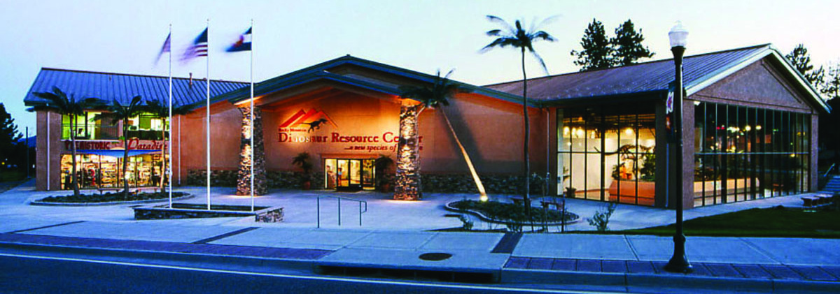
Highlights include Gold Hills Theaters 1 & 2, Rocky Mountain Dinosaur Resource Center, Shining Mountain Golf Club and Memorial Park.
July is the warmest month, with average highs of 74°F; January lows average 9°F.
Weather in Woodland Park
Forecast from the National Weather Service. Full forecast
About Woodland Park
Woodland Park is a home rule municipality in Teller County, Colorado, United States. Woodland Park is part of the Colorado Springs, CO Metropolitan Statistical Area. Many residents in this bedroom community commute to Colorado Springs. Woodland Park is surrounded by the 1,000,000-acre (400,000 ha) Pike National Forest.
From the Wikipedia article Woodland Park, Colorado (this version), under CC BY-SA 4.0.
Things to do2

Gold Hills Theaters 1 & 2
Cinema and theater
615 West Midland Avenue, Woodland Park

Museums and landmarks2
Rocky Mountain Dinosaur Resource Center
Museum · 0.5 mi
Museum in Woodland Park, Colorado
201 South Fairview Street, Woodland Park

Parks, trails and playgrounds10





Restaurants and cafes35

Serrano's Mexican Bar & Grill
Restaurant · Mexican · 1.2 mi
1079 US 24, Woodland Park
Mo-Th 11:00-20:00; Fr-Sa 11:00-21:00

Grandmothers Kitchen
Restaurant · Regional · 0.5 mi
212 US 24, Woodland Park
Tu-Su 06:00-14:00

23 more on the map.
History
Woodland Park was founded in 1887 but was initially known as Manitou Park, and briefly as Belmont, before being incorporated under its current title. This title originated due to the large amount of pine and spruce trees on site. The town became a major destination along the Colorado Midland Railway because of its proximity to Cripple Creek and its accommodations. Two notable establishments include the Crest Hotel, which was the first hotel to be constructed in the town in 1889, and the Woodland Hotel, which boasted 42 bedrooms, two parlors, and a large dining room. Both buildings were eventually torn down.
The Conor M. Jones lumber industry provided the town its initial economic boom. Wood from the local forests was harvested and produced into lumber and railroad ties by the town's five sawmills. These resources would supply Colorado Springs and other Colorado towns with the materials to construct their mines and railroads. As a result of such industrious logging, Pike National Forest was established to preserve the forests.
From the History section of Woodland Park, Colorado on Wikipedia, under CC BY-SA 4.0.
Where to stay6
Microtel Inn & Suites by Wyndham Woodland Park
Motel and hotel · 0.5 mi
722 Country Drive, Woodland Park
Churches and places of worship7
Mountain View United Methodist Church
Church · Methodist · 0.9 mi
1101 Rampart Range Road, Woodland Park
Our Lady of the Woods Catholic Church
Church · Roman Catholic · 0.4 mi
220 South West Street, Woodland Park
Kingdom Hall of Jehovah's Witnesses
Church · Jehovahs Witness · 1.1 mi
1035 South Woodland Avenue, Woodland Park
Shopping9
Woodland Hardware & Home
Hardware store · 0.4 mi
100 Saddle Club Avenue, Woodland Park
Gas and EV charging3
Schools, colleges and libraries8
Woodland Park High School
School · 0.8 mi
151 North Baldwin Street, Woodland Park
Gateway Elementary School
School · 0.8 mi
101 North Baldwin Street, Woodland Park
Woodland Park Public Library
Library · 0.5 mi
218 East Midland Avenue, Woodland Park
Healthcare3
Map of Woodland Park
85 places. The map loads OpenStreetMap tiles when you open it.
Climate by month
Monthly table
| Month | High | Low | Rain |
|---|---|---|---|
| Jan | 33°F | 9°F | 0.7 in |
| Feb | 34°F | 10°F | 0.7 in |
| Mar | 41°F | 18°F | 1.4 in |
| Apr | 47°F | 23°F | 2.1 in |
| May | 56°F | 31°F | 2.0 in |
| Jun | 68°F | 41°F | 1.8 in |
| Jul | 74°F | 47°F | 3.7 in |
| Aug | 71°F | 45°F | 3.2 in |
| Sep | 65°F | 38°F | 1.9 in |
| Oct | 54°F | 27°F | 0.9 in |
| Nov | 42°F | 18°F | 0.7 in |
| Dec | 33°F | 12°F | 0.7 in |
U.S. Climate Normals 1991-2020 for Divide 4Nw (9 mi away), NOAA NCEI.
People and cost of living
American Community Survey 5-year estimates, 2020-2024, U.S. Census Bureau. Estimates have margins of error, larger for small towns.
Disaster history
Teller County has had 10 federal disaster declarations since 2000, most often for fires.
- 2023-08-25: Severe Storms, Flooding, And Tornadoes (Flood)
- 2020-03-28: Covid-19 Pandemic (Biological)
- 2020-03-13: Covid-19 (Biological)
- 2018-06-30: Chateau Fire (Fire)
- 2012-06-28: High Park And Waldo Canyon Wildfires (Fire)
- 2008-06-27: Nash Ranch Fire (Fire)
OpenFEMA disaster declarations summaries.
Getting there and nearby towns
United States Air Force Academy Airfield (AFF) is the nearest airport with scheduled flights listed in OpenStreetMap, 13 miles away.
- Cascade-Chipita Park 5 mi southeast, about 8 min by car
- Air Force Academy 10 mi east, about 17 min by car
- Palmer Lake 11 mi northeast, about 18 min by car
- Monument 12 mi northeast, about 20 min by car
- Manitou Springs 12 mi southeast, about 20 min by car
- Gleneagle 13 mi east, about 21 min by car
- Woodmoor 14 mi northeast, about 22 min by car
- Colorado Springs 18 mi southeast, about 30 min by car
- Black Forest 21 mi east, about 34 min by car
- Cimarron Hills 22 mi southeast, about 35 min by car
Drive times are estimates from straight-line distance, not routes.
Local news
Headlines from INDB, the NEMICO news database.
Reviews, tips and questions
Loading what members have shared...
Sources and licences
- NCES EDGE (Public domain): public schools
- NOAA NCEI U.S. Climate Normals 1991-2020 (Public domain): climate by month
- OpenFEMA (Public domain): disaster declarations
- OpenStreetMap contributors (ODbL 1.0): places, airports, map data
- U.S. Census Bureau (Public domain): population, income, housing, education, commute
- Wikidata (CC0 1.0): elevation, founding date, time zone, website, landmarks and historic places
- Wikimedia Commons (see each image): photos
- Wikipedia (CC BY-SA 4.0): overview and history text
Photo credits
- WPDowntown, Uckrist, Public domain
- RMDRC Tight Cropped, MCDinosaurhunter, CC BY-SA 3.0
Page built October 30, 2026. Spotted a mistake? Tell us or suggest a place.