
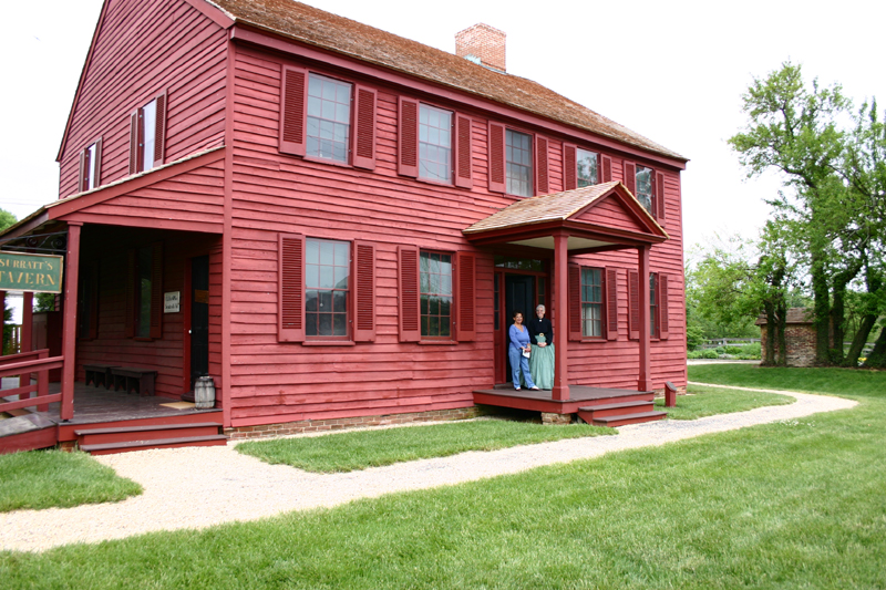


Clinton, Maryland
Clinton is a community of 38,376 people in Prince George's County, Maryland, founded in 1770.
Why visit Clinton
Townapedia lists 9 museums and landmarks, 16 parks and trails, 41 places to eat and 6 places to stay in and around town.
Highlights include Broad Creek, Early Family Historic District, L P Cosca Regional Park and Freedom Park.
July is the warmest month, with average highs of 88°F; January lows average 27°F.
Weather in Clinton
Forecast from the National Weather Service. Full forecast
About Clinton
Clinton is an unincorporated census-designated place (CDP) in Prince George's County, Maryland, United States. Clinton was formerly known as Surrattsville until after the time of the Civil War, and Robeystown from 1865 to 1878. The population of Clinton was 38,760 at the 2020 census. Clinton is historically known for its role in the American Civil War concerning the Abraham Lincoln assassination.
From the Wikipedia article Clinton, Maryland (this version), under CC BY-SA 4.0.
Museums and landmarks9

Broad Creek
Monument and historic site · National Register of Historic Places · 4.9 mi
Unincorporated community in Prince George's County, Maryland

Early Family Historic District
Monument and historic site · National Register of Historic Places · 4.5 mi
Historic district in Maryland, United States

Harmony Hall
Monument and historic site · National Register of Historic Places · 5.1 mi
Historic house in Fort Washington, Maryland, USA

His Lordship's Kindness
Monument and historic site · National Register of Historic Places · 4.3 mi
Historic plantation estate near Rosaryville, Maryland, United States
Surratt House & Tavern
Monument and historic site · National Register of Historic Places · 1.6 mi
Historic house museum in Clinton, Maryland, United States

William W. Early House
Monument and historic site · National Register of Historic Places · 4.5 mi
Historic house in Maryland, United States

Woodstock
Monument and historic site · National Register of Historic Places · 6.0 mi
Plantation house in Maryland

Wyoming
Monument and historic site · National Register of Historic Places · 1.2 mi
Frame historic house located in Clinton in Prince George's County, Maryland, United States
Parks, trails and playgrounds16





4 more on the map.
Restaurants and cafes41

IHOP
Restaurant · Breakfast, Pancake · 2.1 mi
8905 Woodyard Road, Clinton
Mo-Th,Su 07:00-22:00; Fr,Sa 07:00-24:00
Red House American Buffalo Wings Seafoods & Grill
Restaurant · Seafood · 3.6 mi
7075 Allentown Road, Temple Hills
Tu-Th 07:00-19:00; Fr,Sa 07:00-20:00
Naz's Halal Food
Restaurant · 2.1 mi
8909 Woodyard Road, Clinton
Mo-Th 10:30-02:00, Fr-Sa 10:30-04:00, Su 10:30-02:00

Mama Stella's Ristorante Italiano
Restaurant · Italian · 2.7 mi
7918 Old Branch Avenue, Clinton



29 more on the map.
Where to stay6

Family Campground
Campground · 3.2 mi
4520 Wheeling Road, Joint Base Andrews
Mo-Fr 10:00-17:00;Sa,Su,PH off
Open in Google Maps · +1 301 981 3279;+1 301 981 4109;+1 301 981 5663

History
Clinton was founded in the 1770s. The town, then named Surratt's Villa, was actually a simple crossroads with a few buildings. In the 1800s, it became known as Surrattsville. The main building served as the post office, an inn and tavern, and a polling place. This main residence was one of two properties owned by the widowed Mary Surratt; the second property was in Washington, D.C.
On 14 and 15 April 1865, John Wilkes Booth, who had two hours earlier assassinated President Abraham Lincoln, stopped by the Surrattsville tavern to pick up weapons and supplies. The U.S. government alleged that Mary Surratt had gone there earlier with these supplies, and was in collusion with the conspirators, one of whom was her son, John Surratt. Because she was found guilty of complicity in the Lincoln assassination, Mary Surratt was hanged at the Capitol Prison in Washington D.C., on 7 July 1865. (Her house is now the Surratt House Museum, with a focus on the assassination.) The U.S. Post Office renamed the town Robeystown, due to the notoriety of the Surratt name, and in keeping with naming towns after the postmaster. The name was officially changed to Clinton on October 18, 1878. Prince George's County Postbellum Post Offices and Postmasters The local high school, however, retains the name of Surrattsville.
From the History section of Clinton, Maryland on Wikipedia, under CC BY-SA 4.0.
Churches and places of worship37
Chapel of the Incarnation
Church · National Register of Historic Places · 4.3 mi
St. Ignatius Church
Church · National Register of Historic Places · 5.3 mi
St. John's Church
Church · National Register of Historic Places · 5.1 mi
Davies Memorial Unitarian Universalist Church
Place of worship · 3.2 mi
7400 Temple Hill Road, Camp Springs
Kingdom Hall of Jehovahs Witnesses Clinton Congregation
Church · Jehovahs Witness · 3.0 mi
6000 Kirby Road, Clinton
Oxon Hill Church of Christ
Church · Nondenominational · 4.2 mi
4201 Brinkley Road, Temple Hills
Union Bethel AME Church
Church · African Methodist Episcopal · 2.7 mi
8610 Floral Park Road, Brandywine
Shopping10
Gas and EV charging19
Schools, colleges and libraries73
Crossland High School
School · 3.8 mi
6901 Temple Hill Road, Camp Springs
Healthcare2
Map of Clinton
213 places. The map loads OpenStreetMap tiles when you open it.
Climate by month
Monthly table
| Month | High | Low | Rain |
|---|---|---|---|
| Jan | 44°F | 27°F | 3.1 in |
| Feb | 48°F | 28°F | 2.9 in |
| Mar | 56°F | 35°F | 4.0 in |
| Apr | 67°F | 45°F | 3.4 in |
| May | 76°F | 55°F | 4.5 in |
| Jun | 84°F | 64°F | 4.8 in |
| Jul | 88°F | 69°F | 5.0 in |
| Aug | 86°F | 67°F | 4.2 in |
| Sep | 80°F | 60°F | 4.4 in |
| Oct | 68°F | 48°F | 3.8 in |
| Nov | 57°F | 38°F | 3.1 in |
| Dec | 48°F | 31°F | 3.8 in |
U.S. Climate Normals 1991-2020 for Oxon Hill (6 mi away), NOAA NCEI.
People and cost of living
American Community Survey 5-year estimates, 2020-2024, U.S. Census Bureau. Estimates have margins of error, larger for small towns.
Disaster history
Prince George's County has had 13 federal disaster declarations since 2000, most often for hurricanes.
- 2026-01-24: Severe Winter Storm (Winter Storm)
- 2020-03-26: Covid-19 Pandemic (Biological)
- 2020-03-13: Covid-19 (Biological)
- 2016-03-04: Severe Winter Storm And Snowstorm (Snowstorm)
- 2012-11-20: Hurricane Sandy (Hurricane)
- 2012-10-28: Hurricane Sandy (Hurricane)
OpenFEMA disaster declarations summaries.
Getting there and nearby towns
Joint Base Andrews (ADW) is the nearest airport with scheduled flights listed in OpenStreetMap, 5 miles away.
- Camp Springs 4 mi north, about 7 min by car
- Brandywine 4 mi south, about 7 min by car
- Accokeek 7 mi southwest, about 11 min by car
- Bensville 10 mi southwest, about 17 min by car
- Alexandria 11 mi northwest, about 17 min by car
- Brock Hall 12 mi northeast, about 19 min by car
- Washington 13 mi northwest, about 20 min by car
- Arlington 14 mi northwest, about 22 min by car
- Chillum 16 mi north, about 26 min by car
- Bowie 17 mi northeast, about 28 min by car
Drive times are estimates from straight-line distance, not routes.
Local news
Headlines from INDB, the NEMICO news database.
Reviews, tips and questions
Loading what members have shared...
Sources and licences
- NCES EDGE (Public domain): public schools
- NOAA NCEI U.S. Climate Normals 1991-2020 (Public domain): climate by month
- OpenFEMA (Public domain): disaster declarations
- OpenStreetMap contributors (ODbL 1.0): places, airports, map data
- U.S. Census Bureau (Public domain): population, income, housing, education, commute
- Wikidata (CC0 1.0): elevation, founding date, time zone, website, landmarks and historic places
- Wikimedia Commons (see each image): photos
- Wikipedia (CC BY-SA 4.0): overview and history text
Photo credits
- SurrattHouse, Hawkeye58, CC BY-SA 3.0
- Chapel of the Incarnation Dec 08, Pubdog at en.wikipedia, Public domain
- His Lordships Kindness North Dec 08, Pubdog ( talk ), Public domain
- Wyoming Clinton MD 1936, John O. Brostrup, Photographer, Public domain
- St. Ignatius Church Oxon Hill MD Dec 10, Pubdog, Public domain
- Early House Dec 08, Pubdog ( talk ), Public domain
- Broad Creek Church HABS MD1, Albert S. Burns, photographer, Public domain
- Harmony Hall July 17 2008 B, Quarterczar ( talk ), Public domain
- Woodstock 1936, John O. Brostrup, Public domain
- St John's Church Fort Washington, MD 1, Quarterczar ( talk ), Public domain

Page built October 30, 2026. Spotted a mistake? Tell us or suggest a place.