
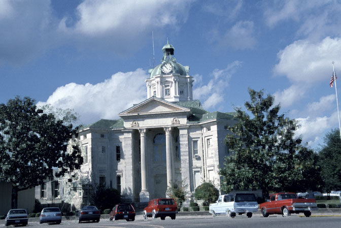


Why visit Columbia
Townapedia lists 1 museum or landmark, 7 parks and trails, 2 places to eat and 1 attraction in and around town.
Highlights include Marion Theater.
August is the warmest month, with average highs of 92°F; January lows average 38°F.
Weather in Columbia
Forecast from the National Weather Service. Full forecast
About Columbia
Columbia is a city in and the county seat of Marion County, Mississippi, United States. Formed six years before Mississippi was admitted to statehood, Columbia was named for Columbia, South Carolina, from which many of the early settlers had migrated. The population was 5,864 as of the 2020 census, down from 6,582 in 2010.
From the Wikipedia article Columbia, Mississippi (this version), under CC BY-SA 4.0.
Things to do1

Museums and landmarks1

Parks, trails and playgrounds7


Restaurants and cafes2

History
Columbia is the county seat of Marion County, which was created out of Amite County in 1811, encompassing the southwest quarter of the current state of Mississippi. Before statehood in 1816, there were three territorial census/poll tax records taken of what was deemed Marion County at the time. These records reveal that during 1813, several Lott men arrived and settled on the Pearl River in what is now Columbia. In 1813, William Lott was the largest slave holder near present-day Columbia, owning 28 people. Five mensettled south of present-day Columbia on 2,789 acres (1,129 ha) of land with 65 enslaved people. North of present-day Columbia, on what was the earliest attempt at a town, Timothy Terrell enslaved 32 people on 3,151 acres (1,275 ha).
The land on which the current city of Columbia resides was first purchased for cash on April 18, 1820, by William Lott and John Lott. This land is Township 3 East, Range 18 West, Section 5 (640 acres), which is now the center of Columbia. Other early patent holders of Columbia include James Phillips, Jr., and John Cooper (1825), in Section 4 next to John and William Lott.
From the History section of Columbia, Mississippi on Wikipedia, under CC BY-SA 4.0.
Churches and places of worship17
Holy Trinity Catholic Church
Church · Roman Catholic · 0.7 mi
1429 North Park Avenue, Columbia
Shopping2
Gas and EV charging2
Schools, colleges and libraries17
East Marion Elementary School
School · 2.7 mi
527 East Marion School Road, Columbia
Healthcare2
Map of Columbia
51 places. The map loads OpenStreetMap tiles when you open it.
Climate by month
Monthly table
| Month | High | Low | Rain |
|---|---|---|---|
| Jan | 60°F | 38°F | 6.5 in |
| Feb | 64°F | 42°F | 5.2 in |
| Mar | 71°F | 48°F | 5.7 in |
| Apr | 78°F | 55°F | 5.2 in |
| May | 85°F | 63°F | 4.3 in |
| Jun | 90°F | 70°F | 5.8 in |
| Jul | 92°F | 72°F | 6.0 in |
| Aug | 92°F | 72°F | 6.0 in |
| Sep | 88°F | 67°F | 3.6 in |
| Oct | 80°F | 56°F | 3.8 in |
| Nov | 69°F | 45°F | 3.9 in |
| Dec | 62°F | 40°F | 5.8 in |
U.S. Climate Normals 1991-2020 for Columbia Hcn (1 mi away), NOAA NCEI.
People and cost of living
American Community Survey 5-year estimates, 2020-2024, U.S. Census Bureau. Estimates have margins of error, larger for small towns.
Disaster history
Marion County has had 25 federal disaster declarations since 2000, most often for hurricanes.
- 2026-02-06: Severe Winter Storm (Winter Storm)
- 2026-01-24: Severe Winter Storm (Winter Storm)
- 2025-05-21: Severe Storms, Straight-Line Winds, Tornadoes, And Flooding (Severe Storm)
- 2021-10-22: Hurricane Ida (Hurricane)
- 2021-08-28: Hurricane Ida (Hurricane)
- 2020-10-08: Hurricane Delta (Hurricane)
OpenFEMA disaster declarations summaries.
Getting there and nearby towns
George R Carr Memorial Air Field (BXA) is the nearest airport with scheduled flights listed in OpenStreetMap, 31 miles away.
- Arnold Line 27 mi east, about 43 min by car
- Hattiesburg 30 mi east, about 48 min by car
- Collins 31 mi northeast, about 49 min by car
- Bogalusa 34 mi south, about 54 min by car
- Franklinton 34 mi southwest, about 55 min by car
- Petal 35 mi east, about 56 min by car
- McComb 39 mi west, about 1 h by car
- Brookhaven 43 mi northwest, about 1 h 15 min by car
- Laurel 49 mi northeast, about 1 h 15 min by car
- Picayune 51 mi south, about 1 h 15 min by car
Drive times are estimates from straight-line distance, not routes.
Local news
Headlines from INDB, the NEMICO news database.
Reviews, tips and questions
Loading what members have shared...
Sources and licences
- NCES EDGE (Public domain): public schools
- NOAA NCEI U.S. Climate Normals 1991-2020 (Public domain): climate by month
- OpenFEMA (Public domain): disaster declarations
- OpenStreetMap contributors (ODbL 1.0): places, airports, map data
- U.S. Census Bureau (Public domain): population, income, housing, education, commute
- Wikidata (CC0 1.0): elevation, founding date, time zone, website
- Wikimedia Commons (see each image): photos
- Wikipedia (CC BY-SA 4.0): overview and history text
Photo credits
- Marion County Mississippi Courthouse, Calvin Beale, Public domain
- Columbia Post Office, Marion County, MS, Gabriel D. May, CC BY-SA 3.0
- Columbia Training School Superintendent's House, Gabriel D. May, CC BY-SA 3.0
- Church Street Historic District, Marion County, MS, Gabriel D. May, CC BY-SA 3.0
- Keys Hill, Governor Hugh White Mansion, Marion County, MS, Gabriel D. May, CC BY-SA 3.0
- Main Street, Marion County, MS, Gabriel D. May, CC BY-SA 3.0
- North Main Historic, Marion County, MS, Gabriel D. May, CC BY-SA 3.0
- Bourne House, Marion County, MS, Gabriel D. May, CC BY-SA 3.0
- Marion County, MS Courthouse, Gabriel D. May, CC BY-SA 3.0


Page built October 30, 2026. Spotted a mistake? Tell us or suggest a place.