


Copper Canyon, Texas
Copper Canyon is a town of 2,514 people in Denton County, Texas, founded in 1973.
Why visit Copper Canyon
Townapedia lists 4 museums and landmarks, 7 parks and trails, 46 places to eat and 1 attraction in and around town.
Highlights include AMC Highland Village 12, Old Alton Bridge, Pilot Knoll Park and Silverthorne Park.
July is the warmest month, with average highs of 96°F; January lows average 34°F.
Weather in Copper Canyon
Forecast from the National Weather Service. Full forecast
About Copper Canyon
Copper Canyon is a town in Denton County, Texas, United States. The population was 1,731 in 2020. Copper Canyon is adjacent to the master-planned Lantana residential development.
From the Wikipedia article Copper Canyon, Texas (this version), under CC BY-SA 4.0.
Things to do1

Museums and landmarks4
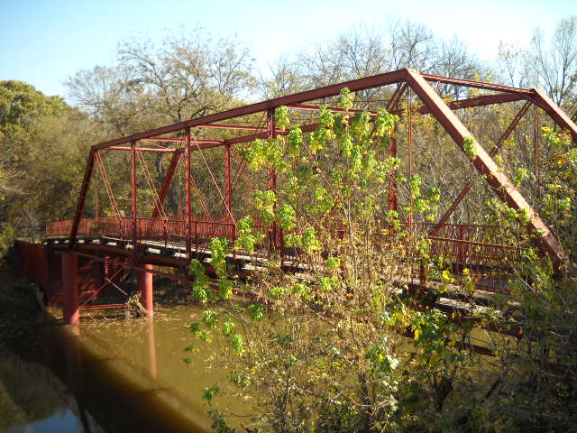
Old Alton Bridge
Bridge · National Register of Historic Places · 2.3 mi
Bridge in Denton County, Texas, United States

Parks, trails and playgrounds7

Pilot Knoll Park
Park · 1.5 mi
Pilot Knoll Park is a beautiful park bordering Lake Lewisville in Highland Village. This park is 65 to 85 acres (depending on the water...
218A Orchid Hill Lane, Highland Village
Mo-Su 05:00-23:00
Silverthorne Park
Park · 1.6 mi
Features: - Benches - Nature Area - Trail ==This 6.54 acre neighborhood park is located within the Briarhill Addition. The park is...
930 Silverthorne Trail, Highland Village
Mo-Su 06:00-23:00
Kensington Park
Park · 2.1 mi
Benches Playscape Picnic Tables Sidewalk Shade Structure
3608 Sussex Way, Corinth
Mo-Su 06:00-22:00

Restaurants and cafes46

Marty B's
Restaurant · Regional, Barbecue · 2.1 mi
2664 FM 407, Bartonville
Su 11:00-21:00, Mo-Th 11:00-22:00, Fr-Sa 11:00-23:00

Marty B's Coffee
Cafe · Coffee Shop · 2.1 mi
2656 FM 407, Bartonville
Su 07:00-17:00, Mo-Th 06:00-21:00, Fr-Sa 06:00-22:00
Torchy's Tacos
Restaurant · Mexican · 1.7 mi
1601 Village Parkway
Mo-Th 07:00-22:00; Fr 07:00-23:00; Sa 08:00-23:00; Su 08:00-22:00
Berries and Batter Cafe
Restaurant · Brunch · 1.7 mi
2100 Village Parkway, Highland Village
Mo-Su 07:00-14:30

Buffalo Wild Wings
Restaurant · Wings · 1.8 mi
3780 Justin Road
Su-Fr 11:00-24:00, Sa 11:00-01:00
Chili's
Restaurant · Tex-Mex · 1.9 mi
6151 Long Prairie Road
Su-Th 10:45-22:00; Fr,Sa 10:45-23:00
Gloria's Latin Cuisine
Restaurant · Mexican · 1.9 mi
Su-Th 11:00-21:00; Fr,Sa 11:00-22:00
Troy Mediterranean Bar and Grill
Restaurant · 1.7 mi
1700 Cottonwood Creek, Highland Village
Tu-Su 09:00-14:30,17:00-21:00
Rosa's Cafe and Tortilla Factory
Restaurant · Mexican · 1.9 mi
3080 Justin Road, Highland Village
34 more on the map.
History
The first European settlement in the area that would become Copper Canyon took place in the 1840s. One of the more prominent settler families was that of Elisha and Mary Chinn, who came to Texas from their original home in North Carolina in 1852. They helped establish the first church in the area, a log-cabin chapel which eventually became known as the Chinn's Chapel Methodist Church. The church is still active on what is now known as Chinn Chapel Road.
The town gradually grew with cattle ranching as the mainstay of the local economy. The railroad came to the area in 1881, and the first public school was constructed in 1884. The town apparently took its name from "Copperhead Canyon," a part of the area formerly known for venomous snakes. Population, never large, generally stagnated or declined in the first half of the twentieth century. After World War II the area's rural charm slowly began to attract residents from the more crowded parts of the Dallas/Fort Worth metroplex.
From the History section of Copper Canyon, Texas on Wikipedia, under CC BY-SA 4.0.
Churches and places of worship3
Chinn's Chapel United Methodist Church;Chinn Chapel
Church · Methodist · 1.3 mi
1000 Chinn Chapel Road, Lewisville
Shopping9
Gas and EV charging3
Schools, colleges and libraries43
Healthcare4
Map of Copper Canyon
120 places. The map loads OpenStreetMap tiles when you open it.
Climate by month
Monthly table
| Month | High | Low | Rain |
|---|---|---|---|
| Jan | 56°F | 34°F | 2.2 in |
| Feb | 60°F | 37°F | 2.8 in |
| Mar | 68°F | 45°F | 3.4 in |
| Apr | 76°F | 53°F | 3.7 in |
| May | 83°F | 63°F | 4.9 in |
| Jun | 91°F | 71°F | 3.6 in |
| Jul | 96°F | 75°F | 2.3 in |
| Aug | 96°F | 74°F | 2.4 in |
| Sep | 88°F | 67°F | 3.0 in |
| Oct | 78°F | 55°F | 4.6 in |
| Nov | 66°F | 44°F | 2.9 in |
| Dec | 57°F | 36°F | 2.7 in |
U.S. Climate Normals 1991-2020 for Denton 2 Se (7 mi away), NOAA NCEI.
People and cost of living
American Community Survey 5-year estimates, 2020-2024, U.S. Census Bureau. Estimates have margins of error, larger for small towns.
Disaster history
Denton County has had 17 federal disaster declarations since 2000, most often for hurricanes.
- 2024-05-17: Severe Storms, Straight-Line Winds, Tornadoes, And Flooding (Flood)
- 2021-02-19: Severe Winter Storms (Severe Ice Storm)
- 2021-02-14: Severe Winter Storm (Severe Ice Storm)
- 2020-03-25: Covid-19 Pandemic (Biological)
- 2020-03-13: Covid-19 (Biological)
- 2015-05-29: Severe Storms, Tornadoes, Straight-Line Winds And Flooding (Severe Storm)
OpenFEMA disaster declarations summaries.
Getting there and nearby towns
Dallas/Fort Worth International Airport (DFW) is the nearest airport with scheduled flights listed in OpenStreetMap, 14 miles away.
- Lantana 1 mi west, about 2 min by car
- Highland Village 2 mi east, about 3 min by car
- Bartonville 3 mi west, about 5 min by car
- Corinth 4 mi northeast, about 6 min by car
- Flower Mound 4 mi south, about 7 min by car
- Lewisville 8 mi southeast, about 13 min by car
- Trophy Club 8 mi southwest, about 14 min by car
- Denton 9 mi north, about 14 min by car
- Roanoke 10 mi southwest, about 15 min by car
- Southlake 10 mi south, about 17 min by car
Drive times are estimates from straight-line distance, not routes.
Local news
Headlines from INDB, the NEMICO news database.
Reviews, tips and questions
Loading what members have shared...
Sources and licences
- NCES EDGE (Public domain): public schools
- NOAA NCEI U.S. Climate Normals 1991-2020 (Public domain): climate by month
- OpenFEMA (Public domain): disaster declarations
- OpenStreetMap contributors (ODbL 1.0): places, airports, map data
- U.S. Census Bureau (Public domain): population, income, housing, education, commute
- Wikidata (CC0 1.0): elevation, founding date, time zone, website, landmarks and historic places
- Wikimedia Commons (see each image): photos
- Wikipedia (CC BY-SA 4.0): overview and history text
Photo credits
- Old Alton Bridge, Ron from Denton, Texas, CC BY 2.0
- ISS018-E-45055 - View of Texas, Earth Science and Remote Sensing Unit , Lyndon B. Johnson Space Center, Public domain
- ISS022-E-53075 - View of Earth, Earth Science and Remote Sensing Unit , Lyndon B. Johnson Space Center, Public domain
- ISS050-E-16232 - View of Earth, Earth Science and Remote Sensing Unit , Lyndon B. Johnson Space Center, Public domain
- ISS022-E-53074 - View of Earth, Earth Science and Remote Sensing Unit , Lyndon B. Johnson Space Center, Public domain
Page built October 30, 2026. Spotted a mistake? Tell us or suggest a place.