


Danbury, Connecticut
Danbury is a city of 87,263 people in Connecticut, founded in 1702.
Why visit Danbury
Townapedia lists 39 museums and landmarks, 101 parks and trails, 142 places to eat, 19 places to stay and 31 attractions in and around town.
Highlights include Bethel Cinema, AMC Loews Danbury 16, Hearthstone Castle and Main Street Historic District.
July is the warmest month, with average highs of 82°F; January lows average 18°F.
Weather in Danbury
Forecast from the National Weather Service. Full forecast
About Danbury
Danbury is a city in Fairfield County, Connecticut, United States, located approximately 50 miles (80 km) northeast of New York City. Danbury's population as of 2020 was 86,518. It is the third-largest city in Western Connecticut, and the seventh-largest city in Connecticut. The city is part of the Western Connecticut Planning Region.
From the Wikipedia article Danbury, Connecticut (this version), under CC BY-SA 4.0.
Things to do31

Brookfield Theatre for the Arts
Cinema and theater · 6.6 mi
Theatre in Brookfield, Connecticut


19 more on the map.
Museums and landmarks39

Hearthstone Castle
Monument and historic site · National Register of Historic Places · 2.1 mi
Castle

Main Street Historic District
Monument and historic site · National Register of Historic Places · 1.3 mi
Historic district in Danbury, Connecticut, United States

New Haven Railroad Danbury Turntable
Monument and historic site · National Register of Historic Places · 1.7 mi
Historic railway turntable in Danbury, Connecticut, United States

Aaron Barlow House
Monument and historic site · National Register of Historic Places · 6.0 mi
House in Redding, Connecticut

Ball and Roller Bearing Company
Monument and historic site · National Register of Historic Places · 1.3 mi
Building in Danbury, United States of America
Brookfield Center Historic District
Monument and historic site · National Register of Historic Places · 6.7 mi
Listed on the NRHP in Brookfield, Connecticut, United States
Charles Ives House
Monument and historic site · National Register of Historic Places · 2.1 mi
Historic house in Connecticut, United States
Cosier-Murphy House
Monument and historic site · National Register of Historic Places · 4.9 mi
New Fairfield, Connecticut, listed on the NRHP in Fairfield County
Danbury Railway Museum
Monument and historic site · National Register of Historic Places · 1.4 mi
Railway museum located in Danbury, Connecticut
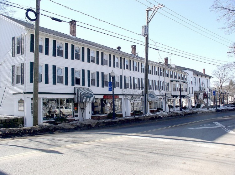
Greenwood Avenue Historic District
Monument and historic site · National Register of Historic Places · 3.9 mi
Historic district in Connecticut, United States

Hugh Cain Fulling Mill and Elias Glover Woolen Mill Archeological Site
Monument and historic site · National Register of Historic Places · 7.0 mi
Archaeological site in Connecticut, United States


John Rider House
Monument and historic site · National Register of Historic Places · 1.8 mi
Historic building in Danbury, Connecticut
27 more on the map.
Parks, trails and playgrounds101


Tarrywile
Park · National Register of Historic Places · 1.9 mi
Park in Danbury, United States of America

Bear Mountain Reservation
Hiking and trails · 3.5 mi
Municipal, Open To Public Without Fee
Bennett Memorial Park
Park · 3.9 mi
It is the policy of the Board of Selectmen to encourage the use of the Bennett Property for the use of Bethel community groups and/or...
Shelter Rock Road, Bethel
Land Conservancy of Ridgefield (Ned's Mountain Road) 4 Parcels
Hiking and trails · 3.9 mi
Private, Open To Public Without Fee

89 more on the map.
Restaurants and cafes142

BarNaan
Restaurant · Indian · 4.0 mi
15 Federal Road, Brookfield
Mo-Th 11:30-21:30; Fr-Sa 11:30-22:30; Su 11:30-21:30
Fiza Restaurant
Restaurant · Pakistani, Indian, Bangladesh · 1.3 mi
7 Backus Avenue
Mo-Th 10:00-20:00; Fr-Sa 10:00-21:00; Su 11:00-18:00

Flobee's Roadside Stand
Diner · American · 5.0 mi
Roadside stand offering burgers, hot dogs, ice cream, soft serve, etc.
680 Danbury Road, Ridgefield
Tu-Su 11:00-20:00
IHOP
Restaurant · Breakfast, Pancake · 2.7 mi
32 Newtown Road, Danbury
Mo-Fr 06:00-21:00; Sa-Su 07:00-21:00
Las Mañanitas
Restaurant · Mexican · 5.3 mi
1250 State Highway 22, Brewster
Su-Th 12:00-21:00; Fr-Sa 12:00-22:00
Maggie McFly's Brookfield
Diner · American · 4.8 mi
195 Federal Road, Brookfield
Mo-Th 11:00-23:00; Fr-Sa 11:00-24:00; Su 10:00-23:00
Mill Plain Diner
Restaurant · American, Diner · 1.2 mi
14 Mill Plain Road, Danbury
Mo-Fr 07:00-21:00; Sa,Su 07:00-20:00
Odeens BBQ Ridgefield Golf Course
Restaurant · Barbecue · 3.9 mi
545 Ridgebury Road, Ridgefield
Mo-Su 08:00-20:00

Starbucks
Cafe · Coffee Shop · 4.4 mi
128 Federal Road, Brookfield
Mo-Fr 04:30-21:00; Sa 05:00-21:00; Su 05:30-21:00
Texas Roadhouse
Restaurant · Steak House · 3.2 mi
74 Newtown Road, Danbury
Mo-Th 15:00-22:00; Fr 15:00-23:00; Sa 11:30-23:00; Su 11:30-22:00
130 more on the map.
History
Danbury was settled by colonists in 1685, when eight families moved from what are now Norwalk and Stamford, Connecticut. The Danbury area was then called Pahquioque by its namesake, the Algonquian-speaking Pahquioque Native Americans (they are believed to have been a band of the Paugussett people), who occupied lands along the Still River. Bands were often identified by such geographic designation but they were associated with the larger nation by culture and language).
One of the original settlers in Danbury was Samuel Benedict, who bought land from the Paquioque in 1685, along with his brother James Benedict, James Beebe, and Judah Gregory. This area was also called Paquiack ("open plain" or "cleared land") by the Paquioque. In recognition of the wetlands, the settlers chose the name Swampfield for their town. In October 1687, the general court decreed the name Danbury. The general court appointed a committee to lay out the new town's boundaries. A survey was made in 1693, and a formal town patent was granted in 1702. It was named Danbury by governor Robert Treat after the Danbury parish in Essex.
From the History section of Danbury, Connecticut on Wikipedia, under CC BY-SA 4.0.
Where to stay19
Howard Johnson by Wyndham Bethel
Motel and hotel · 4.4 mi
21 Stony Hill Road, Bethel
Churches and places of worship65
Ridgebury Congregational Church
Church · United Church Of Christ · National Register of Historic Places · 3.6 mi
605 Ridgebury Road, Ridgefield
Old Southeast Church
Church · National Register of Historic Places · 5.5 mi
St. Andrew's Episcopal Church
Church · National Register of Historic Places · 7.2 mi
Walnut Hill Community Church
Church · Christian · 5.0 mi
156 Walnut Hill Road, Bethel
Bethel United Methodist Church
Church · Methodist · 3.9 mi
141 Greenwood Avenue, Bethel
King Street United Church of Christ
Church · United Church Of Christ · 2.7 mi
201 South King Street, Danbury
Kingdom Hall of Jehovah’s Witnesses
Church · Jehovahs Witness · 5.4 mi
1240 State Highway 22, Brewster
Shopping42
Gas and EV charging35
Schools, colleges and libraries65
Healthcare16
Map of Danbury
250 places. The map loads OpenStreetMap tiles when you open it.
Climate by month
Monthly table
| Month | High | Low | Rain |
|---|---|---|---|
| Jan | 36°F | 18°F | 3.1 in |
| Feb | 39°F | 20°F | 2.7 in |
| Mar | 47°F | 27°F | 3.9 in |
| Apr | 59°F | 37°F | 3.7 in |
| May | 69°F | 46°F | 3.8 in |
| Jun | 78°F | 56°F | 4.5 in |
| Jul | 82°F | 62°F | 4.5 in |
| Aug | 80°F | 60°F | 4.6 in |
| Sep | 74°F | 52°F | 4.8 in |
| Oct | 62°F | 41°F | 4.5 in |
| Nov | 51°F | 31°F | 3.8 in |
| Dec | 41°F | 24°F | 4.2 in |
U.S. Climate Normals 1991-2020 for Danbury Muni Ap (2 mi away), NOAA NCEI.
People and cost of living
American Community Survey 5-year estimates, 2020-2024, U.S. Census Bureau. Estimates have margins of error, larger for small towns.
Disaster history
The county has had 25 federal disaster declarations since 2000, most often for hurricanes.
- 2024-09-20: Severe Storm, Flooding, Landslides, And Mudslides (Severe Storm)
- 2024-08-21: Severe Storms, Flooding, Landslides, And Mudslides (Severe Storm)
- 2021-10-30: Remnants Of Hurricane Ida (Hurricane)
- 2021-08-22: Hurricane Henri (Hurricane)
- 2021-01-12: Tropical Storm Isaias (Hurricane)
- 2020-08-06: Tropical Storm Isaias (Hurricane)
OpenFEMA disaster declarations summaries.
Getting there and nearby towns
Danbury Municipal Airport (DXR) is the nearest airport with scheduled flights listed in OpenStreetMap, 2 miles away.
- Bethel 4 mi southeast, about 7 min by car
- Shelton 19 mi east, about 30 min by car
- Trumbull Center 19 mi southeast, about 30 min by car
- Bridgeport 21 mi southeast, about 33 min by car
- Norwalk 21 mi south, about 34 min by car
- Derby 21 mi east, about 34 min by car
- Stamford 22 mi south, about 36 min by car
- Ansonia 22 mi east, about 35 min by car
- Naugatuck 23 mi east, about 37 min by car
- Waterbury 25 mi northeast, about 41 min by car
Drive times are estimates from straight-line distance, not routes.
Local news
Headlines from INDB, the NEMICO news database.
Reviews, tips and questions
Loading what members have shared...
Sources and licences
- NCES EDGE (Public domain): public schools
- NOAA NCEI U.S. Climate Normals 1991-2020 (Public domain): climate by month
- OpenFEMA (Public domain): disaster declarations
- OpenStreetMap contributors (ODbL 1.0): places, airports, map data
- U.S. Census Bureau (Public domain): population, income, housing, education, commute
- Wikidata (CC0 1.0): elevation, founding date, time zone, website, landmarks and historic places
- Wikimedia Commons (see each image): photos
- Wikipedia (CC BY-SA 4.0): overview and history text
Photo credits
- Danbury Hospital (53563760592), ajay_suresh, CC BY 2.0
- Danburyhart 203, NewFlyer504, CC BY-SA 4.0
- Danbury Fair station site 127, Pedro Xing, CC0
- Danbury, Connecticut downtown aerial view, Quintin Soloviev, CC BY 4.0
- Wooster Square Danbury (2022), CityLimitsJunction, CC0
- Danbury Fair Mall 1, JJBers, CC BY 2.0
- Danbury Fair Mall 2, JJBers, CC BY 2.0
- Sears (Danbury Fair, Danbury, Connecticut) (33285855458), JJBers from Willimantic, Connecticut, USA, CC BY 2.0
- Danbury Fair (53565055205), ajay_suresh, CC BY 2.0
- Osborne Street Victorian, Danbury, Connecticut, CityLimitsJunction, CC0
- Laundromat in Mill Plain, Danbury, CityLimitsJunction, CC0
- Danbury Music Centre (53564808728), ajay_suresh, CC BY 2.0
- Danbury City Hall (53564620781), ajay_suresh, CC BY 2.0
- Danbury, Connecticut (53564808583), ajay_suresh, CC BY 2.0
- Greetings from Danbury, Connecticut - Large Letter Postcard (6002241089), Steve Shook from Moscow, Idaho, USA, CC BY 2.0
- Greeting from The Great Danbury, Connecticut, Fair - Large Letter Postcard (7961039638), Steve Shook from Moscow, Idaho, USA, CC BY 2.0
- DanburyCT BallAndRollerBearingCompany3, Magicpiano, CC BY-SA 4.0
- DanburyCT BallAndRollerBearingCompany1, Magicpiano, CC BY-SA 4.0
- DanburyCT BallAndRollerBearingCompany2, Magicpiano, CC BY-SA 4.0
- View of Danbury Airport from Danbury Fair Mall, AirportExpert, CC0
- Metro-North Siemens Charger at Danbury (1), AirportExpert, CC0
- Metro-North Siemens Charger at Danbury (2), AirportExpert, CC0
- Danbury Ice Arena (53564620451), ajay_suresh, CC BY 2.0
- Danbury Public Library (53564936859), ajay_suresh, CC BY 2.0
- Main Street and Hotel Green, Danbury - 1909 postcard, Unknown author Unknown author, Public domain
- Danbury station postcard, Unknown author Unknown author, Public domain
- Metro-North Siemens Charger at Danbury (3), AirportExpert, CC0
- Danbury Train Station, Danbury, United States (Unsplash), Dmitry Dreyer deemwave, CC0
- Metro-North Siemens Charger at Danbury (4), AirportExpert, CC0
- 23.05.25 Danbury, CT 112 (54570526751), Phil Richards from London, UK, CC BY-SA 2.0
- Danbury Railway Turntable 2016-10-01 - 1, Dmadeo, CC BY-SA 4.0
- Western Connecticut State University (53564936634), ajay_suresh, CC BY 2.0
- RidgefieldCT RidgeburyCongregationalChurch, User:Magicpiano, CC BY-SA 4.0
- Main Street, Danbury, Connecticut, Daniel Case, CC BY-SA 3.0
- Hearthstone Castle in Danbury, CT, Svmrs007, CC BY-SA 4.0
- GreenwoodAveBethelCT, Jerry Dougherty, CC BY 2.5
- BallAndRollerBearingCompanyDanburyCT, Jerry Dougherty, CC BY 2.5
- RidgefieldCT CainGloverMillSite 2, Magicpiano, CC BY-SA 3.0
- Old Southeast Church, Southeast, NY, Daniel Case, CC BY-SA 3.0
- John Rider House, Daniel Case, CC BY-SA 3.0


Page built October 30, 2026. Spotted a mistake? Tell us or suggest a place.