


Naugatuck, Connecticut
Naugatuck is a borough of 31,800 people in Connecticut, founded in 1701.
Why visit Naugatuck
Townapedia lists 32 museums and landmarks, 42 parks and trails, 27 places to eat, 1 place to stay and 19 attractions in and around town.
Highlights include Washington Avenue Bridge, Post University, Salem School and Bank Street Historic District.
July is the warmest month, with average highs of 85°F; January lows average 20°F.
Weather in Naugatuck
Forecast from the National Weather Service. Full forecast
About Naugatuck
Naugatuck (; NAW-gə-tuhk) is a consolidated borough and town in New Haven County, Connecticut, United States. The town, part of the Naugatuck Valley Planning Region, had a population of 31,519 as of the 2020 census.
From the Wikipedia article Naugatuck, Connecticut (this version), under CC BY-SA 4.0.
Things to do19

Washington Avenue Bridge
Bridge · National Register of Historic Places · 4.0 mi
Road bridge in Waterbury, United States of America

Post University
School · 3.6 mi
For-profit university in Waterbury, Connecticut


7 more on the map.
Museums and landmarks32

Salem School
Monument and historic site · National Register of Historic Places · 0.4 mi
Listed on the National Register of Historic Places in New Haven County, Connecticut
124 Meadow St., Naugatuck

Bank Street Historic District
Monument and historic site · National Register of Historic Places · 4.5 mi
Listed on the NRHP
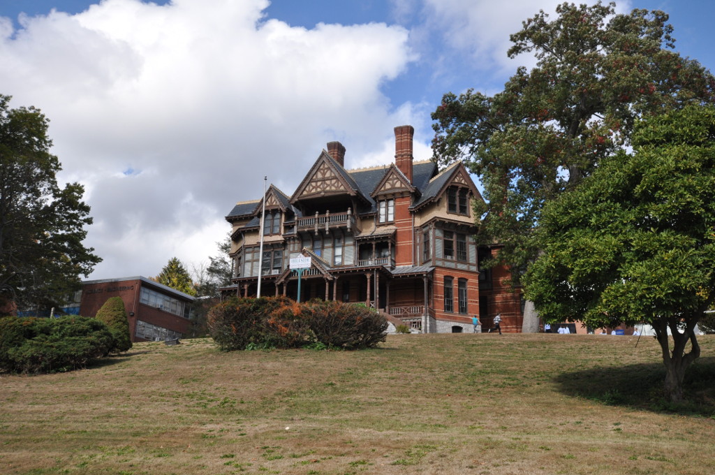
Benedict-Miller House
Monument and historic site · National Register of Historic Places · 5.1 mi
Historic house in Connecticut, United States
Bishop School
Monument and historic site · National Register of Historic Places · 5.3 mi
Historic school building in Waterbury, Connecticut, United States
Bronson B. Tuttle House
Monument and historic site · National Register of Historic Places · 0.6 mi
Historic house in Connecticut, United States

David Hotchkiss House
Monument and historic site · National Register of Historic Places · 3.8 mi
Historic house museum at 61 Waterbury Road in Prospect, Connecticut

Depot Street Bridge
Bridge · National Register of Historic Places · 3.2 mi
Road bridge in Beacon Falls, United States of America

Downtown Waterbury Historic District
Monument and historic site · National Register of Historic Places · 4.8 mi
Historic district in Waterbury, Connecticut, United States

Elton Hotel
Monument and historic site · National Register of Historic Places · 4.8 mi
Historic building in Waterbury, Connecticut, United States


Enoch Hibbard House and George Granniss House
Monument and historic site · National Register of Historic Places · 4.7 mi
Historic houses in Connecticut, United States
George S. Abbott Building
Monument and historic site · National Register of Historic Places · 4.9 mi
Building in Connecticut, United States
Hillside Historic District
Monument and historic site · National Register of Historic Places · 5.0 mi
Historic district in Waterbury, Connecticut, United States
20 more on the map.
Parks, trails and playgrounds42

Hamilton Park
Park · National Register of Historic Places · 4.0 mi
Oldest city park in Waterbury, Connecticut

Country Club Of Waterbury
Golf course · 3.3 mi
Private, Members Or Owners Only
1 Oronoke Road, Waterbury
Beacon Falls Town Recreation Field
Park · 3.3 mi
Municipal, Open To Public Without Fee

30 more on the map.
Restaurants and cafes27

G's Burgers
Restaurant · American, Ice Cream · 1.0 mi
778 New Haven Road, Naugatuck




15 more on the map.
History
Settlement began as early as 1702. Samuel Hickox (1669–1713), credited as Naugatuck’s first settler, established a fulling mill on Fulling Mill Brook in 1709. The locality was known as Judds Meadow until 1752, when it was renamed Salem Bridge.
In 1844, parts of Waterbury, Bethany, and Oxford incorporated as the town of Naugatuck. The Borough of Naugatuck was established in 1893 and became coextensive with the town in 1895.
As the Industrial Revolution accelerated, Naugatuck developed a diverse manufacturing base and became a center of the rubber industry. In 1892, nine firms consolidated to form the United States Rubber Company (later Uniroyal Inc.), organized in Naugatuck, which for decades kept major operations in the borough. In 1936, U.S. Rubber introduced Naugahyde, a vinyl-coated fabric invented by company chemists in Naugatuck; the material was manufactured locally for many years.
The United States Rubber Company also created the Naugatuck Chemical Company in the early 20th century; the business later became Uniroyal Chemical and relocated major operations to Middlebury, Connecticut in the 1970s.
The Risdon Manufacturing Company, established in Naugatuck in the early 1900s, became a leading maker of metal closures and cosmetic packaging and later operated regionally under Crown Risdon.
From the History section of Naugatuck, Connecticut on Wikipedia, under CC BY-SA 4.0.
Where to stay1
Churches and places of worship20
Our Lady of Fatima Roman Catholic Church
Church · Roman Catholic · 2.6 mi
2071 Baldwin Street, Waterbury
Congregational Church of Naugatuck
Church · United Church Of Christ
9 Division Street, Naugatuck
Holy Saviour Polish National Church
Church · Polish National Catholic · 1.1 mi
118 Prospect Street, Naugatuck
Saint Francis of Assisi Roman Catholic Church
Church · Roman Catholic · 0.4 mi
294 Church Street, Naugatuck
Saint Paul's Lutheran Church
Church · Lutheran · 0.8 mi
350 Millville Avenue, Naugatuck
Shopping2
Gas and EV charging11
Schools, colleges and libraries53
Healthcare2
Map of Naugatuck
209 places. The map loads OpenStreetMap tiles when you open it.
Climate by month
Monthly table
| Month | High | Low | Rain |
|---|---|---|---|
| Jan | 38°F | 20°F | 3.6 in |
| Feb | 41°F | 22°F | 3.5 in |
| Mar | 48°F | 28°F | 4.4 in |
| Apr | 60°F | 38°F | 4.7 in |
| May | 71°F | 48°F | 3.7 in |
| Jun | 79°F | 58°F | 4.9 in |
| Jul | 85°F | 64°F | 3.8 in |
| Aug | 84°F | 62°F | 3.8 in |
| Sep | 76°F | 55°F | 4.3 in |
| Oct | 64°F | 43°F | 4.9 in |
| Nov | 52°F | 34°F | 4.3 in |
| Dec | 42°F | 26°F | 4.5 in |
U.S. Climate Normals 1991-2020 for Mt Carmel (10 mi away), NOAA NCEI.
People and cost of living
American Community Survey 5-year estimates, 2020-2024, U.S. Census Bureau. Estimates have margins of error, larger for small towns.
Disaster history
The county has had 27 federal disaster declarations since 2000, most often for severe storms.
- 2024-10-24: Hawthorne Fire (Fire)
- 2024-09-20: Severe Storm, Flooding, Landslides, And Mudslides (Severe Storm)
- 2024-08-21: Severe Storms, Flooding, Landslides, And Mudslides (Severe Storm)
- 2021-10-30: Remnants Of Hurricane Ida (Hurricane)
- 2021-08-22: Hurricane Henri (Hurricane)
- 2021-01-12: Tropical Storm Isaias (Hurricane)
OpenFEMA disaster declarations summaries.
Getting there and nearby towns
Waterbury-Oxford Airport (OXC) is the nearest airport with scheduled flights listed in OpenStreetMap, 4 miles away.
- Waterbury 5 mi north, about 8 min by car
- Oakville 7 mi north, about 12 min by car
- Cheshire Village 8 mi east, about 13 min by car
- Watertown 9 mi northwest, about 14 min by car
- Heritage Village 9 mi west, about 15 min by car
- Quinnipiac University 9 mi southeast, about 15 min by car
- Woodbury Center 9 mi northwest, about 14 min by car
- Ansonia 10 mi south, about 16 min by car
- Derby 11 mi south, about 18 min by car
- Sandy Hook 11 mi southwest, about 18 min by car
Drive times are estimates from straight-line distance, not routes.
Local news
Headlines from INDB, the NEMICO news database.
Reviews, tips and questions
Loading what members have shared...
Sources and licences
- NCES EDGE (Public domain): public schools
- NOAA NCEI U.S. Climate Normals 1991-2020 (Public domain): climate by month
- OpenFEMA (Public domain): disaster declarations
- OpenStreetMap contributors (ODbL 1.0): places, airports, map data
- U.S. Census Bureau (Public domain): population, income, housing, education, commute
- Wikidata (CC0 1.0): elevation, founding date, time zone, website, landmarks and historic places
- Wikimedia Commons (see each image): photos
- Wikipedia (CC BY-SA 4.0): overview and history text
Photo credits
- U.S. Post Office, Naugatuck, CT, Bill Hass, CC BY-SA 3.0
- Naugatuck Green, Connecticut, Kenneth C. Zirkel, CC BY-SA 4.0
- Naugatuck station 037, Pedro Xing, CC0
- Naugatuck Civil War Memorial, Connecticut, Kenneth C. Zirkel, CC BY-SA 4.0
- Naugatuck Town Green, Connecticut, Kenneth C. Zirkel, CC BY-SA 4.0
- Congregational Church, Naugatuck, Connecticut, Kenneth C. Zirkel, CC BY-SA 4.0
- Whittemore Library, Naugatuck, Connecticut, Kenneth C. Zirkel, CC BY-SA 4.0
- Naugatuck Savings Bank, Connecticut, Kenneth C. Zirkel, CC BY-SA 4.0
- Naugatuck station photo postcard, Unknown author Unknown author, Public domain
- Naugatuck station platform at night July 2026 2, 4300streetcar, CC BY 4.0
- Naugatuck Station, Adam Moss, CC BY-SA 2.0
- Naugatuck station platform at night July 2026 1, 4300streetcar, CC BY 4.0
- Another image of Salem School, Naugatuck, CT, Bill Hass, CC BY-SA 3.0
- Salem School, Naugatuck, CT, Bill Hass, CC BY-SA 3.0
- Naugatuck Civil War Monument. On the Green., Bill Hass, CC BY-SA 3.0
- NaugatuckCT BronsonBTuttleHouse, Magicpiano, CC BY-SA 4.0
- Waterbury Branch train near Naugatuck, December 2012, ricky-from-left-field, CC BY 2.0
- Waterbury Branch train near Naugatuck, December 2012 (cropped), ricky-from-left-field, CC BY 2.0
- The Larkin Trail in Whittemore Glen State Park in Naugatuck Connecticut, Morrowlong, CC BY-SA 4.0
- Larkin State Park Trail, Naugatuck CT, John Phelan, CC BY-SA 4.0
- Larkin State Park Trail Mile 1, Naugatuck CT, John Phelan, CC BY-SA 4.0
- NaugatuckSFWestBlockNorthCT8AndRiver, Morrowlong, CC BY-SA 3.0
- NaugatuckTrailNaugatuckStateForestBeaconFallsCT-CTRoute8Border, Morrowlong, CC BY-SA 3.0
- BeaconFalls DepotStreetBridge, Magicpiano, CC BY-SA 4.0
- NathanielRichardsonHouse, Bruce Clouette, Public domain
- ProspectCT CenterSchool, Jerry Dougherty, CC BY 2.5
- United States Post Office-Naugatuck Main - Connecticut 2012-09, Quickhatch, CC BY-SA 3.0
- BeaconFallsCT HomeWoolenCompany1, Magicpiano, CC BY-SA 4.0
- WaterburyCT WashingtonAvenueBridge, Magicpiano, CC BY-SA 4.0
- WaterburyCT HillsideHD 4, Magicpiano, CC BY-SA 4.0
- Downtown Waterbury, CT, Daniel Case, CC BY-SA 3.0
- WaterburyCT BrassMillSite1, Magicpiano, CC BY-SA 4.0
- PalaceTheater-WaterburyCT-1, Koskenart, CC BY-SA 4.0
- WaterburyCT WaterburyClockCompany, Magicpiano, CC BY-SA 4.0
- WaterburyCT HibbardAndGrannissHouses, Magicpiano, CC BY-SA 4.0
- Bank Street Historic District, Waterbury, CT, Daniel Case, CC BY-SA 3.0
- Elton Hotel, Waterbury, CT, Daniel Case, CC BY-SA 3.0
- David Hotchkiss House, LisaHendricks, CC BY-SA 3.0
- NaugatuckCT WhittemoreLibrary, User:Magicpiano, CC BY-SA 4.0
- Grand entrance to the school April 2015 jpg, Robert E. Brown, CC BY-SA 4.0


Page built October 30, 2026. Spotted a mistake? Tell us or suggest a place.