
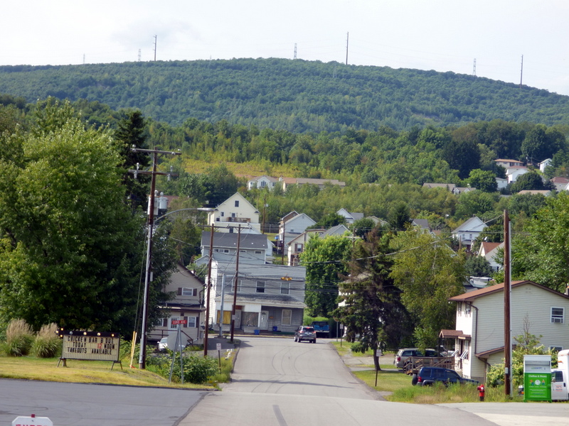


Dickson City, Pennsylvania
Dickson City is a borough of 6,023 people in Lackawanna County, Pennsylvania, founded in 1859.
Why visit Dickson City
Townapedia lists 13 museums and landmarks, 18 parks and trails, 39 places to eat, 6 places to stay and 4 attractions in and around town.
Highlights include Circle Drive-in Theater, Marywood University, Albright Memorial Building and Century Club of Scranton.
July is the warmest month, with average highs of 85°F; January lows average 20°F, and about 45 inches of snow fall in a normal year.
Weather in Dickson City
Forecast from the National Weather Service. Full forecast
About Dickson City
Dickson City is a borough in Lackawanna County, Pennsylvania, United States, 4 miles (6 km) north of Scranton. Coal mining was an important industry in the past. The borough's population peaked at 12,395 in 1930 and was 6,051 at the 2020 census.
From the Wikipedia article Dickson City, Pennsylvania (this version), under CC BY-SA 4.0.
Things to do4


Marywood University
School · 2.4 mi
Private Catholic liberal arts university in Scranton, Pennsylvania. United States
Regal Cinema Dickson City 14 & IMAX
Cinema and theater
3909 Commerce Boulevard, Dickson City

Museums and landmarks13

Albright Memorial Building
Monument and historic site · National Register of Historic Places · 4.1 mi
Library in Scranton, Pennsylvania

Century Club of Scranton
Monument and historic site · National Register of Historic Places · 4.0 mi
Building in Pennsylvania, United States

Dickson Works
Monument and historic site · National Register of Historic Places · 4.0 mi
Historic industrial building in Scranton, Pennsylvania, United States

Florence Apartments
Monument and historic site · National Register of Historic Places · 4.0 mi
Multifamily residential in Pennsylvania, United States of America

Joseph Cassese House
Monument and historic site · National Register of Historic Places · 3.9 mi
Historic house in Pennsylvania, United States

North Scranton Junior High School
Monument and historic site · National Register of Historic Places · 2.8 mi
High school in Pennsylvania, United States

Scranton Armory
Monument and historic site · National Register of Historic Places · 3.8 mi
Arsenal in Pennsylvania, United States of America

Silkman House
Monument and historic site · National Register of Historic Places · 2.3 mi
Historic house located in Pennsylvania, USA

Terence V. Powderly House
Monument and historic site · National Register of Historic Places · 4.0 mi
Historic house in Pennsylvania, United States

Tripp Family Homestead
Monument and historic site · National Register of Historic Places · 3.4 mi
Building in Pennsylvania, United States


Scranton Lace Company
Monument and historic site · National Register of Historic Places · 3.1 mi

Houdini Museum
Museum · 2.8 mi
Biographical museum in Scranton, Pennsylvania, USA
1 more on the map.
Parks, trails and playgrounds18


6 more on the map.
Restaurants and cafes39

Chuck E. Cheese
Restaurant · Pizza · 0.5 mi
1003 Commerce Boulevard, Dickson City
Mo-Fr,Su 11:00-21:00; Sa 10:00-22:00
Olive Garden
Restaurant · Italian
1500 Scranton Carbondale Highway, Scranton
Mo-Th,Su 11:00-22:00; Fr-Sa 11:00-23:00

TGI Fridays
Diner · American · 0.8 mi
620 Scranton Carbondale Highway, Scranton
Mo-Th,Su 11:00-22:00; Fr-Sa 11:00-23:00

Greek American Grill
Restaurant · 0.9 mi
540 Scranton Carbondale Highway
Mo-Th,Su 07:00-21:00; Fr-Sa 07:00-22:00

DK's Corner
Diner · American · 2.1 mi
Mo,We-Sa 10:00-19:00; Tu 10:00-14:00; Su off
27 more on the map.
History
Dickson City was once known as Priceburg. It was the newest village in the valley and one of the most progressive. German immigrants then founded the village of Priceville in 1863, in honor of Eli Price. This section of the town developed rapidly after 1880, when John Jermyn sank the shaft which is now known as the Johnson shaft. Here the population had grown from 329 to 841.
In June 1875, Dickson City was incorporated as a borough, including at the time all of the present borough of Throop. Dickson City received its name from Thomas Dickson, founder of the Dickson Manufacturing Company.
Once dominated by coal mines, this borough has in recent times become the center of a retail corridor focused along Business Route 6 and around the Viewmont Mall. Many of the nation's big-box stores and chain restaurants are represented here.
Most of the newer retail complexes are located along Viewmont Drive and Commerce Boulevard, both built by developers to access the borough's vast dormant coal lands. Some of the centers that were built in the 1990s and early 2000s include Dickson City Crossings, Dickson City Commons, Park Center and Commerce Plaza.
After Route 6 (also named the Scranton/Carbondale Highway), Main Street serves as the borough's other major thoroughfare. It features a slightly older stock of stores, bars, professional offices and homes.
From the History section of Dickson City, Pennsylvania on Wikipedia, under CC BY-SA 4.0.
Where to stay6
Home2 Suites by Hilton Dickson City Scranton
Motel and hotel · 0.5 mi
914 Scranton Carbondale Highway, Dickson City
Churches and places of worship13
Holy Trinity Polish National Catholic Church
Church · Catholic · 1.8 mi
619 Center Street, Throop
Saint Mary's Cathedral
Church · Catholic · 0.9 mi
1090 Carmalt Street, Dickson City
Shopping25
Gas and EV charging5
Schools, colleges and libraries40
Howard Gardner Multiple Intelligence Cs
School · 5.9 mi
1615 East Elm Street, Scranton
Healthcare3
Map of Dickson City
166 places. The map loads OpenStreetMap tiles when you open it.
Climate by month
Monthly table
| Month | High | Low | Rain | Snow |
|---|---|---|---|---|
| Jan | 36°F | 20°F | 2.6 in | 11.7 in |
| Feb | 39°F | 22°F | 2.1 in | 10.9 in |
| Mar | 48°F | 29°F | 2.8 in | 10.1 in |
| Apr | 61°F | 39°F | 3.3 in | 0.8 in |
| May | 72°F | 50°F | 3.3 in | 0.0 in |
| Jun | 80°F | 58°F | 3.8 in | 0.0 in |
| Jul | 85°F | 63°F | 3.6 in | 0.0 in |
| Aug | 82°F | 61°F | 3.9 in | 0.0 in |
| Sep | 75°F | 54°F | 4.2 in | 0.0 in |
| Oct | 63°F | 43°F | 3.7 in | 0.7 in |
| Nov | 51°F | 34°F | 2.9 in | 3.2 in |
| Dec | 40°F | 26°F | 2.8 in | 7.7 in |
U.S. Climate Normals 1991-2020 for Wilkes-Barre Intl Ap 72513 (10 mi away), NOAA NCEI.
People and cost of living
American Community Survey 5-year estimates, 2020-2024, U.S. Census Bureau. Estimates have margins of error, larger for small towns.
Disaster history
Lackawanna County has had 13 federal disaster declarations since 2000, most often for severe storms.
- 2020-03-30: Covid-19 Pandemic (Biological)
- 2020-03-13: Covid-19 (Biological)
- 2018-11-27: Severe Storms And Flooding (Severe Storm)
- 2012-10-29: Hurricane Sandy (Hurricane)
- 2011-09-12: Tropical Storm Lee (Flood)
- 2011-09-08: Remnants Of Tropical Storm Lee (Flood)
OpenFEMA disaster declarations summaries.
Getting there and nearby towns
Wilkes-Barre/Scranton International Airport (AVP) is the nearest airport with scheduled flights listed in OpenStreetMap, 10 miles away.
- Chinchilla 2 mi northwest, about 3 min by car
- Blakely 2 mi northeast, about 3 min by car
- Clarks Summit 4 mi west, about 6 min by car
- Dunmore 4 mi southeast, about 7 min by car
- Clarks Green 4 mi northwest, about 6 min by car
- Scranton 5 mi south, about 8 min by car
- Archbald 5 mi northeast, about 8 min by car
- Dalton 7 mi northwest, about 12 min by car
- Carbondale 10 mi northeast, about 16 min by car
- Factoryville 10 mi northwest, about 16 min by car
Drive times are estimates from straight-line distance, not routes.
Local news
Headlines from INDB, the NEMICO news database.
Reviews, tips and questions
Loading what members have shared...
Sources and licences
- NCES EDGE (Public domain): public schools
- NOAA NCEI U.S. Climate Normals 1991-2020 (Public domain): climate by month
- OpenFEMA (Public domain): disaster declarations
- OpenStreetMap contributors (ODbL 1.0): places, airports, map data
- U.S. Census Bureau (Public domain): population, income, housing, education, commute
- Wikidata (CC0 1.0): elevation, founding date, time zone, website, landmarks and historic places
- Wikimedia Commons (see each image): photos
- Wikipedia (CC BY-SA 4.0): overview and history text
Photo credits
- Dickson City PA, Jared Kofsky/PlaceNJ.com, CC BY-SA 4.0
- Century Club Scranton PA, Smallbones, CC0
- Joseph Cassese House Scranton PA, Smallbones, CC0
- Florence Apts Scranton PA, Smallbones, CC0
- Scranton PA Jr High Main Ave, Smallbones, CC0
- Scranton PA Armory, Smallbones, CC0
- Dickson Works Nov 09, Doug Kerr from Albany, NY, United States, CC BY-SA 2.0
- Tripp House side Scranton PA, Smallbones, CC0
- Silkman House, Scranton, Stanley Jones, Public domain
- Terence Powderly House, Daniel Case, CC BY-SA 3.0
- Scranton, PA, Public Library IMG 1519, Billy Hathorn ( talk ), CC BY-SA 3.0
- Scranton Lace Company Scranton PA, Smallbones, CC0
Page built October 30, 2026. Spotted a mistake? Tell us or suggest a place.