

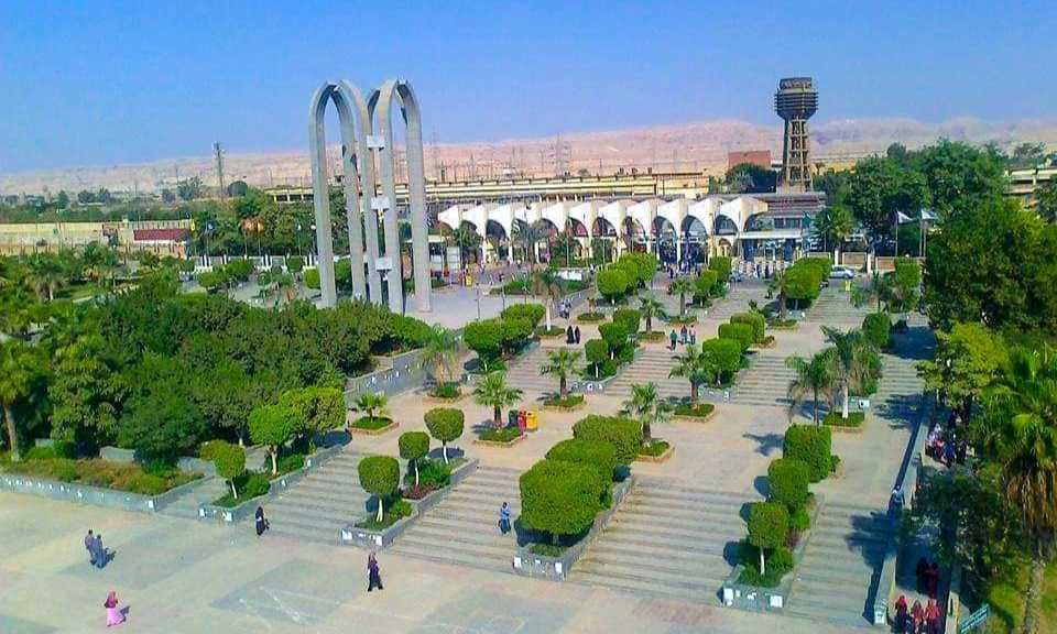


Why visit Al Badrashayn
Townapedia lists 11 museums and landmarks and 1 place to eat in and around town.
Highlights include Bubasteion of Saqqara and Farouk Corner Museum.
Weather in Al Badrashayn
Forecast from MET Norway (CC BY 4.0). Full forecast
About Al Badrashayn
Badrashin (Arabic: البدرشين) is a city, and capital of the eponymous markaz, in Giza Governorate, Egypt.
From the Wikipedia article Badrashin (this version), under CC BY-SA 4.0.
Museums and landmarks11

Bubasteion of Saqqara
Monument and historic site · 4.9 km
Ptolemaic and Roman temple complex in Saqqara, Egypt

Helwan cemetery
Monument and historic site · 3.3 km
Archaeological site in Cairo, Egypt

Mastabet el-Fara'un
Monument and historic site · 5.1 km
Ancient Egyptian mastaba tomb


Pyramid of Djoser
Monument and historic site · 5.4 km
Archeological site in Egypt

Pyramid of Khendjer
Monument and historic site · 4.6 km
Smooth-sided pyramid


Saqqara
Monument and historic site · 3.2 km
Village in Giza Governorate, Egypt

Restaurants and cafes1

Churches and places of worship1

Shopping4

Schools, colleges and libraries6
Map of Al Badrashayn
23 places. The map loads OpenStreetMap tiles when you open it.
Getting there and nearby towns
Cairo International Airport (CAI) is the nearest airport with scheduled flights listed in OpenStreetMap, 33 km away.
- Ḩalwān 3 km east, about 3 min by car
- Giza 19 km north, about 19 min by car
- 6th of October City 21 km west, about 21 min by car
- Cairo 24 km north, about 24 min by car
- New Cairo 28 km northeast, about 28 min by car
- Shubrā al Khaymah 31 km north, about 31 min by car
- Al-'Ubūr 47 km northeast, about 47 min by car
- Badr 54 km northeast, about 54 min by car
- Al ‘Āshir min Ramaḑān 68 km northeast, about 1 h 15 min by car
- Zagazig 85 km north, about 1 h 30 min by car
Drive times are estimates from straight-line distance, not routes.
Local news
Headlines from INDB.
Reviews, tips and questions
Loading what members have shared...
Sources and licences
- GeoNames (CC BY 4.0): population, coordinates, regions and time zone
- OpenStreetMap contributors (ODbL 1.0): places, airports, map data
- Wikidata (CC0 1.0): elevation, founding date, time zone, website, landmarks and historic places
- Wikimedia Commons (see each image): photos
- Wikipedia (CC BY-SA 4.0): overview and history text
Photo credits
- Date harvest, Doaa Adel, CC BY-SA 4.0
- جامعة حلوان, Hamed.ragab.shoma, CC BY-SA 4.0
- متحف ركن مالك فاروق 1, IslamAboAmer, CC BY-SA 4.0
- Imhotep-Museum (Sakkara) 02, Olaf Tausch, CC BY 3.0
- Sakkara 01, Olaf Tausch, CC BY 3.0
- Khendjer-complexe-1, MONNIER Franck ([email protected]), CC BY 2.5
- Saqqara, Ancient Egypt, Vyacheslav Argenberg, CC BY 4.0
- Memphis, Ramses II, Ancient Egypt, Vyacheslav Argenberg, CC BY 4.0
- Memphis200401, No machine-readable author provided. Neithsabes assumed (based on copyright claims)., Public domain
- Museo Mit Rahina-Memphis (2), Alberto-g-rovi, CC BY 3.0
- Museo Mit Rahina-Memphis (1), Alberto-g-rovi, CC BY 3.0
- Égypte, Memphis (Mit Rahina), Musée en plein air, Statue de Ramsès II, c.1279-1213 (XIXe dynastie) (49639403488), Marie Thérèse Hébert & Jean Robert Thibault from Québec, Canada, CC BY-SA 2.0
- Memphis Museum 25, Olaf Tausch, CC BY 3.0
- Memphis Museum 06, Olaf Tausch, CC BY 3.0
- Memphis Museum 21, Olaf Tausch, CC BY 3.0
- Memphis Museum 27, Olaf Tausch, CC BY 3.0
- Memphis Museum 22, Olaf Tausch, CC BY 3.0
- Memphis Museum 07, Olaf Tausch, CC BY 3.0
- Memphis Museum 08, Olaf Tausch, CC BY 3.0
- Memphis Museum 26, Olaf Tausch, CC BY 3.0
- Memphis Museum 21a, Olaf Tausch, CC BY 3.0
- Memphis Museum 20, Olaf Tausch, CC BY 3.0
- Memphis Museum 24, Olaf Tausch, CC BY 3.0
- Memphis Museum 23, Olaf Tausch, CC BY 3.0
- Égypte, Memphis (Mit Rahina), Musée en plein air, Statue en granite rouge (49639403133), Marie Thérèse Hébert & Jean Robert Thibault from Québec, Canada, CC BY-SA 2.0
- Égypte, Memphis (Mit Rahina), Musée en plein air, Statue en granite rouge (49640200747), Marie Thérèse Hébert & Jean Robert Thibault from Québec, Canada, CC BY-SA 2.0
- 2006 Saqqara, Jon Evans, CC BY 2.0
- Mit Rahinah, Al Badrashin, Giza Governorate, Egypt - panoramio (5), EliziR, CC BY-SA 3.0
- Égypte, Memphis (Mit Rahina), Musée en plein air, Statue de Ramsès II, c.1279-1213 (XIXe dynastie) (49639403268), Marie Thérèse Hébert & Jean Robert Thibault from Québec, Canada, CC BY-SA 2.0
- Égypte, Memphis (Mit Rahina), Musée en plein air, Sarcophage (couvercle) (49640204007), Marie Thérèse Hébert & Jean Robert Thibault from Québec, Canada, CC BY-SA 2.0
- Égypte, Memphis (Mit Rahina), Musée en plein air, Sarcophage (49639930396), Marie Thérèse Hébert & Jean Robert Thibault from Québec, Canada, CC BY-SA 2.0
- Statue of Ramses II in Memphis Museum 孟菲斯博物館拉姆瑟斯二世像 - panoramio (1), lienyuan lee, CC BY 3.0
- Statue of Ramses II in Memphis Museum 孟菲斯博物館拉姆瑟斯二世像 - panoramio, lienyuan lee, CC BY 3.0
- Sphinx in Memphis Museum 孟菲斯博物館獅身人面像 - panoramio, lienyuan lee, CC BY 3.0
- The Alabaster Sphinx 雪花狮身人面像 - panoramio, lienyuan lee, CC BY 3.0
- Égypte, Memphis (Mit Rahina), Musée en plein air, Sphinx de Memphis, Nouvel Empire (c.1550-1069 BC) (49639405438), Marie Thérèse Hébert & Jean Robert Thibault from Québec, Canada, CC BY-SA 2.0
- Memphis BW 1, Berthold Werner, CC BY-SA 3.0
- Memphis BW 2, Berthold Werner, CC BY 3.0
- Esfinge de Memphis (2), Alberto-g-rovi, CC BY 3.0
- Esfinge de Memphis (1), Alberto-g-rovi, CC BY 3.0
- Bubasteion, Saqqara (2), Richard Mortel, CC BY 2.0


Page built November 8, 2026. Spotted a mistake? Tell us or suggest a place.