
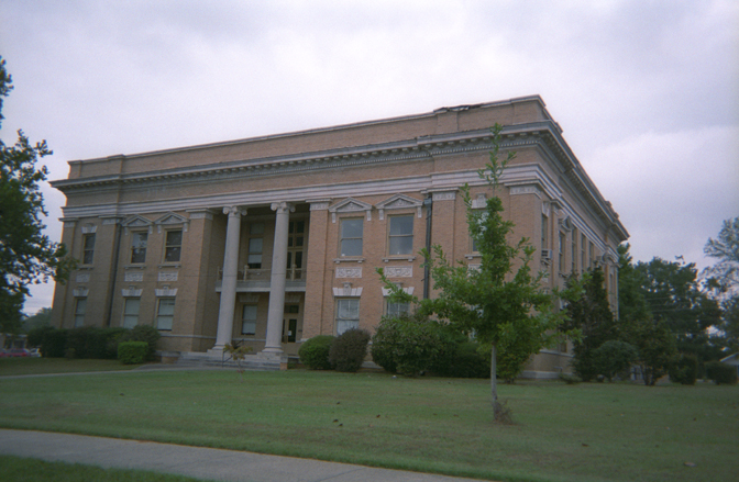


Ellisville, Mississippi
Ellisville is a city of 4,521 people in Jones County, Mississippi.
Why visit Ellisville
Townapedia lists 5 museums and landmarks, 5 parks and trails, 17 places to eat and 2 attractions in and around town.
Highlights include Amos Deason House and Amos Deason Home.
July is the warmest month, with average highs of 93°F; January lows average 35°F.
Weather in Ellisville
Forecast from the National Weather Service. Full forecast
About Ellisville
Ellisville is a town in and the first county seat of Jones County, Mississippi, United States. As of the 2020 census, Ellisville had a population of 4,652. The Jones County Courthouse is located here, as is much of the county government.
From the Wikipedia article Ellisville, Mississippi (this version), under CC BY-SA 4.0.
Things to do2


Museums and landmarks5

Amos Deason House
Monument and historic site · National Register of Historic Places · 1.1 mi
House in Ellisville, Mississippi
Parks, trails and playgrounds5

Restaurants and cafes17

Casadores Mexican Grill
Restaurant · Mexican · 0.9 mi
100 Jessamine Street, Ellisville
Su-Sa 11:00-21:00


Domino's
Fast food · Pizza · 0.9 mi
800 Hill Street, Ellisville
Mo-Th 10:00-23:00; Fr-Sa 10:00-24:00; Su 10:00-23:00
Little Caesars
Fast food · Pizza · 0.9 mi
500 Hill Street, Ellisville
Mo-Th 10:00-21:30; Fr 10:00-22:00; Sa 10:00-21:30; Su 10:00-21:00
McDonald's
Fast food · Burger · 0.9 mi
701 Hill Street, Ellisville
Mo-Th 05:30-23:59; Fr 05:30-23:59; Sa 00:00-01:00, 05:30-23:59; Su...
5 more on the map.
History
The town is named for Powhatan Ellis, a former U.S. senator for Mississippi who identified as a descendant of Pocahontas and her father, Chief Powhatan in Virginia. Ellisville was designated as the county seat, and it became the major commercial and population center of Jones County through the early decades of development in the nineteenth century.
During the Civil War, Ellisville and Jones County were a center of pro-Union resistance. The county had mostly yeomen farmers and cattle herders, who were not slaveholders. Slaves constituted 12% of the county's population in 1860, the lowest proportion of slaves of any county in the state in 1860, as conditions generally did not support cultivation of large cotton plantations. Many local men resented going to war to support slaveholders, and worried about the survival of their families, where women and children worked to keep subsistence farms going. They resented Confederate tax collectors who took the goods and stores their families needed to live.
From the History section of Ellisville, Mississippi on Wikipedia, under CC BY-SA 4.0.
Churches and places of worship13
Ellisville First United Methodist Church
Church · Methodist · 1.0 mi
202 South Church Street, Ellisville
Tula Rosa Congregational Methodist Church
Church · Methodist · 1.5 mi
Augusta Road, Ellisville
Ellisville First Assembly of God
Church · Pentecostal · 1.2 mi
312 US 11, Ellisville
Pleasant Grove Missionary Baptist Church
Church · Baptist · 2.7 mi
Dacetown Road, Ellisville
Shopping5
Gas and EV charging5
Schools, colleges and libraries5
Healthcare5
Jones County Health Department
Clinic and pharmacy · 2.7 mi
5168 US 11, Ellisville
Map of Ellisville
62 places. The map loads OpenStreetMap tiles when you open it.
Climate by month
Monthly table
| Month | High | Low | Rain | Snow |
|---|---|---|---|---|
| Jan | 60°F | 35°F | 6.1 in | 0.0 in |
| Feb | 65°F | 38°F | 5.1 in | 0.0 in |
| Mar | 72°F | 45°F | 5.5 in | 0.0 in |
| Apr | 79°F | 52°F | 5.1 in | 0.0 in |
| May | 85°F | 60°F | 4.3 in | 0.0 in |
| Jun | 91°F | 68°F | 5.5 in | 0.0 in |
| Jul | 93°F | 70°F | 5.4 in | 0.0 in |
| Aug | 93°F | 70°F | 5.5 in | 0.0 in |
| Sep | 89°F | 64°F | 3.9 in | 0.0 in |
| Oct | 80°F | 52°F | 3.5 in | 0.0 in |
| Nov | 70°F | 42°F | 4.1 in | 0.0 in |
| Dec | 62°F | 37°F | 5.8 in | 0.0 in |
U.S. Climate Normals 1991-2020 for Laurel Hcn (7 mi away), NOAA NCEI.
People and cost of living
American Community Survey 5-year estimates, 2020-2024, U.S. Census Bureau. Estimates have margins of error, larger for small towns.
Disaster history
Jones County has had 23 federal disaster declarations since 2000, most often for hurricanes.
- 2026-02-06: Severe Winter Storm (Winter Storm)
- 2026-01-24: Severe Winter Storm (Winter Storm)
- 2023-08-12: Severe Storms, Straight-Line Winds, And Tornadoes. (Severe Storm)
- 2021-10-22: Hurricane Ida (Hurricane)
- 2021-08-28: Hurricane Ida (Hurricane)
- 2020-10-28: Hurricane Zeta (Hurricane)
OpenFEMA disaster declarations summaries.
Getting there and nearby towns
Hesler-Noble Field (LUL) is the nearest airport with scheduled flights listed in OpenStreetMap, 6 miles away.
- Laurel 7 mi northeast, about 12 min by car
- Soso 11 mi north, about 18 min by car
- Ovett 13 mi southeast, about 21 min by car
- Sharon 15 mi northeast, about 25 min by car
- Petal 17 mi south, about 28 min by car
- Glendale 17 mi south, about 27 min by car
- Arnold Line 20 mi southwest, about 33 min by car
- Hattiesburg 21 mi south, about 34 min by car
- Collins 21 mi west, about 34 min by car
- Columbia 43 mi southwest, about 1 h 15 min by car
Drive times are estimates from straight-line distance, not routes.
Local news
Headlines from INDB, the NEMICO news database.
Reviews, tips and questions
Loading what members have shared...
Sources and licences
- NOAA NCEI U.S. Climate Normals 1991-2020 (Public domain): climate by month
- OpenFEMA (Public domain): disaster declarations
- OpenStreetMap contributors (ODbL 1.0): places, airports, map data
- U.S. Census Bureau (Public domain): population, income, housing, education, commute
- Wikidata (CC0 1.0): elevation, founding date, time zone, website, landmarks and historic places
- Wikimedia Commons (see each image): photos
- Wikipedia (CC BY-SA 4.0): overview and history text
Photo credits
- Jones County Mississippi Courthouse, Calvin Beale, Public domain
- Historic Hotel Alice and Ballroom - Ellisville, Mississippi, Paul Lowry, CC BY 2.0
- The Varsity Theater - Ellisville, Mississippi, Paul Lowry, CC BY 2.0
- Ellisville, Mississippi Post Office, Paul Lowry, CC BY 2.0
- Bennie & Mae's Ice Cream Shop - Ellisville, Mississippi, Paul Lowry, CC BY 2.0
- Ellisville Fire Station and City Hall, Paul Lowry, CC BY 2.0
- ISS062-E-144103 - View of Earth, Earth Science and Remote Sensing Unit, NASA Johnson Space Center, Public domain
- ISS062-E-143128 - View of Earth, Earth Science and Remote Sensing Unit, NASA Johnson Space Center, Public domain
- ISS053-E-178267 - View of Earth, Earth Science and Remote Sensing Unit , Lyndon B. Johnson Space Center, Public domain
- ISS043-E-128494 - View of Earth, Earth Science and Remote Sensing Unit , Lyndon B. Johnson Space Center, Public domain
- ISS059-E-78691 - View of Earth, Earth Science and Remote Sensing Unit, NASA Johnson Space Center, Public domain
- ISS043-E-128495 - View of Earth, Earth Science and Remote Sensing Unit , Lyndon B. Johnson Space Center, Public domain
- ISS043-E-240681 - View of Earth, Earth Science and Remote Sensing Unit , Lyndon B. Johnson Space Center, Public domain
- ISS062-E-144104 - View of Earth, Earth Science and Remote Sensing Unit, NASA Johnson Space Center, Public domain
- ISS043-E-240682 - View of Earth, Earth Science and Remote Sensing Unit , Lyndon B. Johnson Space Center, Public domain
- The Amos Deason Home, Librarylady2726, CC BY-SA 3.0
- Bynum-Anderson House, Bulverdejack, CC BY-SA 4.0
- Bynum Home 03, Bulverdejack, CC BY-SA 4.0


Page built October 30, 2026. Spotted a mistake? Tell us or suggest a place.