




Elmsford, New York
Elmsford is a village of 5,186 people in Westchester County, New York.
Why visit Elmsford
Townapedia lists 35 museums and landmarks, 12 parks and trails, 18 places to eat, 6 places to stay and 2 attractions in and around town.
Highlights include Irvington Town Hall, Beaver Hill, Armour-Stiner House and Bar Building.
July is the warmest month, with average highs of 86°F; January lows average 23°F, and about 33 inches of snow fall in a normal year.
Weather in Elmsford
Forecast from the National Weather Service. Full forecast
About Elmsford
Elmsford is a village in Westchester County, New York, United States. It is part of the New York metropolitan area. Roughly one square mile, the village is fully contained within the borders of the town of Greenburgh. As of the 2020 census, Elmsford had a population of 5,239.
From the Wikipedia article Elmsford, New York (this version), under CC BY-SA 4.0.
Things to do2

Irvington Town Hall
Cinema and theater · National Register of Historic Places · 3.0 mi
Theatre in Irvington, New York

Museums and landmarks35
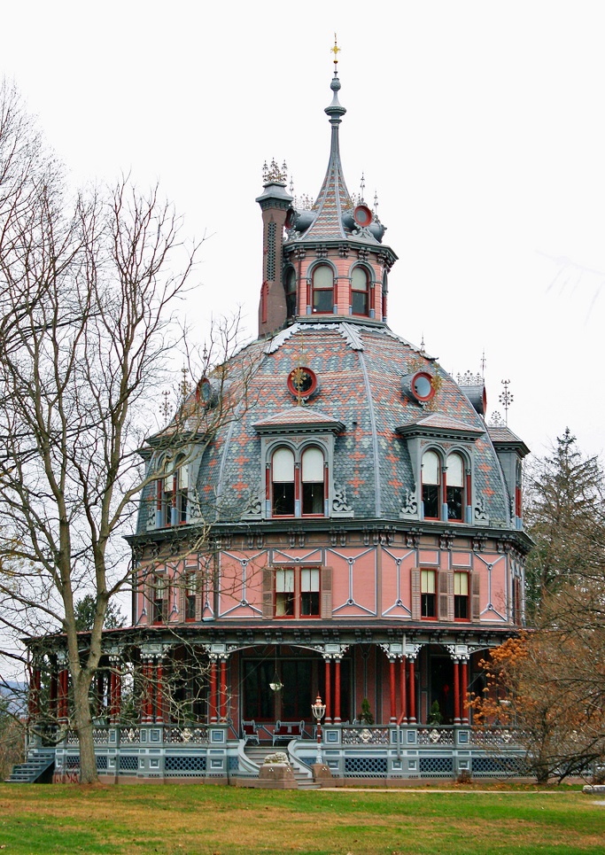
Armour-Stiner House
Monument and historic site · National Register of Historic Places · 3.3 mi
Historic house in Irvington, New York, United States

Bar Building
Monument and historic site · National Register of Historic Places · 2.9 mi
Historic commercial building in New York, United States

East Irvington School
Monument and historic site · National Register of Historic Places · 1.8 mi
School building in New York, United States of America

Edward Harden Mansion
Monument and historic site · National Register of Historic Places · 3.0 mi
Historic house in New York, United States

Elijah Miller House
Museum · National Register of Historic Places · 2.3 mi
Historic house in New York, United States

Elmsford Reformed Church and Cemetery
Monument and historic site · National Register of Historic Places
Historic church in New York, United States

Evangeline Booth House
Monument and historic site · National Register of Historic Places · 2.5 mi
Historic house in Hartsdale, New York, USA

Glenwolde Park Historic District
Monument and historic site · National Register of Historic Places · 2.5 mi
Historic district in Tarrytown, New York

Good Counsel Complex
Monument and historic site · National Register of Historic Places · 2.8 mi
In White Plains, New York, United States

Hammond House
Monument and historic site · National Register of Historic Places · 1.5 mi
Historic house in New York, United States

Hartsdale Pet Cemetery
Monument and historic site · National Register of Historic Places · 2.4 mi
Pet cemetery in Greenburgh, New York

Hartsdale station
Monument and historic site · National Register of Historic Places · 3.1 mi
Railway station in New York, US
23 more on the map.
Parks, trails and playgrounds12


Patriot's Park
Park · National Register of Historic Places · 3.0 mi
Westchester County, New York



Restaurants and cafes18

Captain Lawrence Brewing Company
Brewery and winery · 1.1 mi
444 Saw Mill River Road, Elmsford
We-Th 16:00-22:00; Fr 12:00-22:00; Sa 12:00-20:00; Su 12:00-19:00

Royal Palace
Restaurant · Indian · 1.2 mi
Indian Restaurant
77 Knollwood Road, White Plains
Mo-Th 11:30-21:30; Fr-Sa 11:30-22:00; Su 11:30-21:00
Racanelli's Original Pizza & Brew
Restaurant · Italian · 1.2 mi
85 Knollwood Road, Greenburgh
Tu-Su 11:30-21:00


Crosswest Office Building
Cafe · Burger, Coffee Shop · 0.8 mi
399 Knollwood Road, White Plains


6 more on the map.
History
Elmsford was largely farmland throughout its early history. The construction of railroads in the late 19th century brought new prominence to the area, and in 1910 it was incorporated as a village.
The area was known from colonial times as "Storm's Bridge" and later, "Hall's Corners", names derived from the principal landowners of the times. In 1870, the growing village was officially renamed "Elmsford" in honor of a local landmark, a giant elm tree which no longer exists. The names Elmsford and Storm's Bridge are reminders of the nearby Saw Mill River, which once had significant tributaries flowing through the village.
A longstanding legend holds that Elmsford is the birthplace of the term "cocktail". According to the tale, a local colonial tavern (sometimes said to be established by town father Isaac Storm) had run out of wooden stirrers during the war and started using the quills of roosters' tailfeathers to stir their drinks; a more embellished version holds that the roosters were plundered from nearby Tory farmers.
Much of Elmsford developed around the New York and Putnam Railroad station, with train service beginning in the 1870s. Commuter rail service ended in 1958, and freight service ended in 1975. The railroad bed is now the South County Trailway and North County Trailway. The train station building is now a restaurant.
From the History section of Elmsford, New York on Wikipedia, under CC BY-SA 4.0.
Where to stay6
Churches and places of worship10
Christ Episcopal Church
Church · National Register of Historic Places · 2.7 mi
Church of St. Barnabas
Church · National Register of Historic Places · 2.8 mi
First Baptist Church of Tarrytown
Church · National Register of Historic Places · 2.7 mi
Foster Memorial AME Zion Church
Church · National Register of Historic Places · 3.1 mi
Union Church of Pocantico Hills
Church · National Register of Historic Places · 3.0 mi
Kingdom Hall of Jehovah’s Witnesses
Church · Jehovahs Witness · 1.5 mi
49 Gibson Avenue, White Plains
Shopping5
Gas and EV charging5
Schools, colleges and libraries48
Healthcare2
Map of Elmsford
143 places. The map loads OpenStreetMap tiles when you open it.
Climate by month
Monthly table
| Month | High | Low | Rain | Snow |
|---|---|---|---|---|
| Jan | 40°F | 23°F | 3.9 in | 9.4 in |
| Feb | 43°F | 24°F | 3.3 in | 10.9 in |
| Mar | 51°F | 31°F | 4.4 in | 5.8 in |
| Apr | 63°F | 40°F | 4.3 in | 0.7 in |
| May | 73°F | 50°F | 4.3 in | 0.0 in |
| Jun | 81°F | 59°F | 4.6 in | 0.0 in |
| Jul | 86°F | 64°F | 4.5 in | 0.0 in |
| Aug | 84°F | 63°F | 4.4 in | 0.0 in |
| Sep | 77°F | 56°F | 4.6 in | 0.0 in |
| Oct | 65°F | 45°F | 4.4 in | 0.0 in |
| Nov | 54°F | 36°F | 3.9 in | 0.3 in |
| Dec | 44°F | 29°F | 4.7 in | 5.6 in |
U.S. Climate Normals 1991-2020 for Dobbs Ferry-Ardsley Hcn (3 mi away), NOAA NCEI.
People and cost of living
American Community Survey 5-year estimates, 2020-2024, U.S. Census Bureau. Estimates have margins of error, larger for small towns.
Disaster history
Westchester County has had 21 federal disaster declarations since 2000, most often for hurricanes.
- 2024-01-30: Severe Storm And Flooding (Flood)
- 2021-09-05: Remnants Of Hurricane Ida (Hurricane)
- 2021-09-02: Remnants Of Hurricane Ida (Hurricane)
- 2021-08-22: Hurricane Henri (Hurricane)
- 2020-10-02: Tropical Storm Isaias (Hurricane)
- 2020-03-20: Covid-19 Pandemic (Biological)
OpenFEMA disaster declarations summaries.
Getting there and nearby towns
Westchester County Airport (HPN) is the nearest airport with scheduled flights listed in OpenStreetMap, 6 miles away.
- Tarrytown 3 mi west, about 5 min by car
- Ardsley 3 mi southwest, about 5 min by car
- White Plains 4 mi southeast, about 6 min by car
- Dobbs Ferry 4 mi southwest, about 7 min by car
- Sleepy Hollow 4 mi northwest, about 7 min by car
- Scarsdale 5 mi southeast, about 7 min by car
- Harrison 5 mi southeast, about 9 min by car
- Briarcliff Manor 6 mi north, about 10 min by car
- Eastchester 7 mi south, about 11 min by car
- Yonkers 8 mi south, about 13 min by car
Drive times are estimates from straight-line distance, not routes.
Local news
Headlines from INDB, the NEMICO news database.
Reviews, tips and questions
Loading what members have shared...
Sources and licences
- NCES EDGE (Public domain): public schools
- NOAA NCEI U.S. Climate Normals 1991-2020 (Public domain): climate by month
- OpenFEMA (Public domain): disaster declarations
- OpenStreetMap contributors (ODbL 1.0): places, airports, map data
- U.S. Census Bureau (Public domain): population, income, housing, education, commute
- Wikidata (CC0 1.0): elevation, founding date, time zone, website, landmarks and historic places
- Wikimedia Commons (see each image): photos
- Wikipedia (CC BY-SA 4.0): overview and history text
Photo credits
- Elmsford dog pound jeh, Jim.henderson, CC0
- East Irvington School, Beyond My Ken, CC BY 3.0
- 2 and 8 North Grove Street, Tarrytown, NY, Daniel Case, CC BY-SA 3.0
- Armour-Stiner House (1), csouza_79, CC BY 2.0
- Evangeline Booth House, PointsofNoReturn, CC BY-SA 4.0
- Patriot's Park, Tarrytown-Sleepy Hollow, NY, Daniel Case, CC BY-SA 3.0
- Lyndhurst Tarrytown NY - front facade, Unknown author, CC BY-SA 3.0
- HartsdaleNY LeoFriedlanderStudio, User:Magicpiano, CC BY-SA 4.0
- Washington Irving Memorial Irvington, Beyond My Ken, CC BY-SA 4.0
- Mapleton, Joshua Koerner, CC BY-SA 3.0
- White Plains Rural Cemetery 2012-09-23 12-26 jeh, jim.henderson, CC BY-SA 3.0
- First Baptist Church of Tarrytown, NY, Daniel Case, CC BY-SA 3.0
- Hartford-hall, Dmadeo, CC BY-SA 4.0
- Tarrytown Music Hall 2010, Ed from Queens, USA. Cropped and color-corrected slightly prior to upload by Daniel Case, CC BY 2.0
- Elijahmillerhouse, NortyNort ( talk ), CC BY-SA 3.0
- Christ Episcopal Church, Tarrytown, NY, Daniel Case, CC BY-SA 3.0
- WhitePlainsNY GoodCounselChapel, User:Magicpiano, CC BY-SA 4.0
- Hartsdale Pet Cemetery October 2012, Anthony22, CC BY-SA 3.0
- McVickar House, Irvington, NY, Daniel Case, CC BY-SA 3.0
- HarrisonNY StonyHillCemetery2, Magicpiano, CC BY-SA 4.0
- HStation, Cmvahlkamp, Public domain
- Lord and Burnham Building, Daniel Case, CC BY-SA 3.0
- Jacob Purdy House, GaoKyle, CC BY-SA 4.0
- Percy Grainger Home and Studio, Jesús Jiménez Flores, CC BY-SA 3.0
- Church of St Barnabas, Irvington, NY, Daniel Case, CC BY-SA 3.0
- Kykuit, Tarrytown, NY - front facade, The original uploader was Daderot at English Wikipedia ., CC BY-SA 3.0
- TarrytownNY GlenwoldeParkHD 1, Magicpiano, CC BY-SA 4.0
- Villa-lewaro crop, Dmadeo ; cropped by Beyond My Ken ( talk ) 19:28, 23 March 2011 (UTC), CC BY-SA 4.0
- Foster Memorial AME Zion Church, Daniel Case, CC BY-SA 3.0
- TarrytownNY FormerWashingtonIrvingHighSchool, Magicpiano, CC BY-SA 4.0
- Bar Building 2012-09-23 jeh, jim.henderson, CC BY-SA 3.0
- Hammond House, Hawthorne, NY, Daniel Case, CC BY-SA 3.0
- GreenburghNY RomerVanTasselHouse, Magicpiano, CC BY-SA 4.0
- Odell House 1, PointsofNoReturn, CC BY-SA 4.0
- Edward Harden Mansion, Sleepy Hollow, NY, Daniel Case, CC BY-SA 3.0
- Peoples National Bank and Trust Company Building 31 Mamaroneck Av jeh, jim.henderson, CC BY-SA 3.0
- ArmoryWhitePlains, KForce, CC BY-SA 3.0
- WhitePlainsNY YWCA Housing, User:Magicpiano, CC BY-SA 4.0


Page built October 30, 2026. Spotted a mistake? Tell us or suggest a place.