


Fairland, Maryland
Fairland is a community of 26,231 people in Montgomery County, Maryland.
Why visit Fairland
Townapedia lists 3 museums and landmarks, 37 parks and trails, 43 places to eat and 2 places to stay in and around town.
Highlights include Ammendale Normal Institute, Milimar, Columbia Park and National Capital Curling Center.
July is the warmest month, with average highs of 89°F; January lows average 26°F.
Weather in Fairland
Forecast from the National Weather Service. Full forecast
About Fairland
Fairland is a census-designated place and an unincorporated area in Montgomery County, Maryland, United States. It had a population of 25,396 per the 2020 census.
From the Wikipedia article Fairland, Maryland (this version), under CC BY-SA 4.0.
Museums and landmarks3
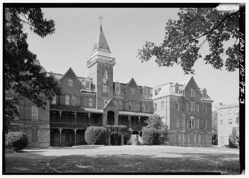
Ammendale Normal Institute
Monument and historic site · National Register of Historic Places · 3.3 mi
Historical Catholic novitiate and school, operated by the Christian Brothers in Beltsville, Maryland, United States

Milimar
Monument and historic site · National Register of Historic Places · 3.7 mi
Historic home located in Silver Spring, Montgomery County, Maryland, United States


Rachel Carson House
Monument and historic site · National Register of Historic Places · 3.5 mi
Where Rachel Carson wrote Silent Spring, listed on the U.S. National Register of Historic Places
Parks, trails and playgrounds37

Columbia Park
Park · 1.5 mi
Columbia Local Park’s recreational features include a playground, several ball fields, and tennis courts.
14900 Old Columbia Pike, Burtonsville

National Capital Curling Center
Sports field and stadium · 1.7 mi
13810 Old Gunpowder Road, West Laurel


Maydale Conservation Park
Hiking and trails · 1.9 mi
Maydale Conservation Park, a parcel of land dedicated to environmental preservation, is home to the Maydale Nature Classroom, two ponds,...
1638 Maydale Drive, Silver Spring
The Gardens Ice House
Sports field and stadium · 1.6 mi
13810 Old Gunpowder Road
25 more on the map.
Restaurants and cafes43

Cuba De Ayer
Restaurant · Cuban · 2.1 mi
Lunch Served Tues - Fri 11:30 am - 3:00 pm
15446 Old Columbia Pike, Burtonsville
Tu-Th, Su 11:30-21:00; Fr-Sa 11:30-22:00; Mo closed

Ahadu Ethiopian Cuisine
Restaurant · Ethiopian · 2.2 mi
15510 Old Columbia Pike, Burtonsville
Mo-Su 12:00-21:00
Open in Google Maps · +1-240-722-6900; +1-202-717-4654; +1-240-722-6924
Barra Brava Cevicheria Peruana
Restaurant · Peruvian · 2.1 mi
15420 Old Columbia Pike, Burtonsville
Mo-Th 10:00-21:00; Fr-Sa 10:00-00:00; Su 08:00-21:00
Tropicana
Restaurant · Jamaican
13886 Old Columbia Pike, Silver Spring
Mo-Sa 11:00-21:30; Su 11:00-18:00
Gong Cha and Fuji Teriyaki
Restaurant · Asian, Bubble Tea · 1.8 mi
12058 Cherry Hill Road, Silver Spring
31 more on the map.
Where to stay2

Churches and places of worship21
Abyssinia Baptist Church
Church · Baptist · 1.2 mi
3106 Fairland Road, Silver Spring
Renaissance Baptist Church
Church · Baptist · 1.8 mi
3411 Spencerville Road, Burtonsville
Saint Gregorios Indian Orthodox Church
Church · Oriental Orthodox · 0.6 mi
2337 Fairland Road, Silver Spring
Shopping6
Gas and EV charging8
Schools, colleges and libraries55
Healthcare3
Map of Fairland
178 places. The map loads OpenStreetMap tiles when you open it.
Climate by month
Monthly table
| Month | High | Low | Rain |
|---|---|---|---|
| Jan | 43°F | 26°F | 3.5 in |
| Feb | 46°F | 28°F | 2.7 in |
| Mar | 55°F | 35°F | 4.2 in |
| Apr | 67°F | 45°F | 3.8 in |
| May | 76°F | 55°F | 4.4 in |
| Jun | 84°F | 64°F | 4.4 in |
| Jul | 89°F | 69°F | 4.2 in |
| Aug | 87°F | 68°F | 3.8 in |
| Sep | 80°F | 61°F | 4.7 in |
| Oct | 68°F | 50°F | 4.4 in |
| Nov | 57°F | 39°F | 3.5 in |
| Dec | 47°F | 31°F | 3.9 in |
U.S. Climate Normals 1991-2020 for Laurel 3 W Hcn (3 mi away), NOAA NCEI.
People and cost of living
American Community Survey 5-year estimates, 2020-2024, U.S. Census Bureau. Estimates have margins of error, larger for small towns.
Disaster history
Montgomery County has had 15 federal disaster declarations since 2000, most often for hurricanes.
- 2026-01-24: Severe Winter Storm (Winter Storm)
- 2020-03-26: Covid-19 Pandemic (Biological)
- 2020-03-13: Covid-19 (Biological)
- 2016-03-04: Severe Winter Storm And Snowstorm (Snowstorm)
- 2012-11-20: Hurricane Sandy (Hurricane)
- 2012-10-28: Hurricane Sandy (Hurricane)
OpenFEMA disaster declarations summaries.
Getting there and nearby towns
College Park Airport (CGS) is the nearest airport with scheduled flights listed in OpenStreetMap, 7 miles away.
- Calverton 2 mi south, about 3 min by car
- Colesville 3 mi west, about 4 min by car
- Cloverly 3 mi northwest, about 4 min by car
- Burtonsville 3 mi north, about 5 min by car
- Beltsville 3 mi southeast, about 5 min by car
- College Park 6 mi south, about 10 min by car
- Adelphi 6 mi south, about 9 min by car
- Aspen Hill 7 mi west, about 11 min by car
- Chillum 8 mi south, about 13 min by car
- East Riverdale 9 mi south, about 14 min by car
Drive times are estimates from straight-line distance, not routes.
Local news
Headlines from INDB, the NEMICO news database.
Reviews, tips and questions
Loading what members have shared...
Sources and licences
- NCES EDGE (Public domain): public schools
- NOAA NCEI U.S. Climate Normals 1991-2020 (Public domain): climate by month
- OpenFEMA (Public domain): disaster declarations
- OpenStreetMap contributors (ODbL 1.0): places, airports, map data
- U.S. Census Bureau (Public domain): population, income, housing, education, commute
- Wikidata (CC0 1.0): elevation, founding date, time zone, website, landmarks and historic places
- Wikimedia Commons (see each image): photos
- Wikipedia (CC BY-SA 4.0): overview and history text
Photo credits
- 2019-08-07 09 30 22 View south along U.S. Route 29 (Columbia Pike) at the exit for Maryland State Route 200 WEST (TO Interstate 270) in Fairland, Montgomery County, Maryland, Famartin, CC BY-SA 4.0
- 2019-08-07 09 31 40 View south along U.S. Route 29 (Columbia Pike) at the exits for Maryland State Route 200 EAST (TO Interstate 95) and Fairland Road in Fairland, Montgomery County, Maryland, Famartin, CC BY-SA 4.0
- Hip Hop Fish and Chicken restaurant Fairland MD 2024-06-19 08-48-27, G. Edward Johnson, CC BY 4.0
- 2019-09-03 09 53 19 View north along U.S. Route 29 (Columbia Pike) from the overpass for the ramp from northbound U.S. Route 29 to westbound Maryland State Route 200 in Fairland, Montgomery County..., Famartin, CC BY-SA 4.0
- 2019-09-03 09 53 05 View south along U.S. Route 29 (Columbia Pike) from the overpass for the ramp from northbound U.S. Route 29 to westbound Maryland State Route 200 in Fairland, Montgomery County..., Famartin, CC BY-SA 4.0
- Briggs Chaney Center parking lot Fairland MD 2024-06-19 08-49-12 1, G. Edward Johnson, CC BY 4.0
- 2019-09-03 10 02 43 View south along U.S. Route 29 (Columbia Pike) from the overpass for Briggs Chaney Road in Fairland, Montgomery County, Maryland, Famartin, CC BY-SA 4.0
- 7-Eleven Pizza Hut Fairland MD 2024-06-19 08-50-01, G. Edward Johnson, CC BY 4.0
- 2008 11 06 - Fairland - US29 viewed from Briggs Chaney Rd 2, Andrew Bossi, CC BY-SA 2.5
- 2008 11 06 - Fairland - US29 viewed from Briggs Chaney Rd 1, Andrew Bossi, CC BY-SA 2.5
- U.S. Route 29 at Briggs Chaney Road grade separation project in Fairland, Andrew Bossi, CC BY-SA 2.5
- Ammendale SE 1990, Jack Boucher, Public domain
- Milimar, Farragutful, CC BY-SA 3.0
- Rachel carson house md, Eli.pousson, CC BY-SA 3.0
- St. John the Baptist SSMD 01, Farragutful, CC BY-SA 3.0
- Saint John's Episcopal Church (Beltsville, Maryland), Farragutful, CC BY-SA 3.0
- St andrew cathedral ss, Farragutful, CC BY-SA 3.0
- 2007-05-10 - BriggsChaney-OldColumbia - SE corner looking east, Andrew Bossi, CC BY-SA 2.5
- 2007-05-10 - BriggsChaney-OldColumbia - SW corner looking northwest 2, Andrew Bossi, CC BY-SA 2.5
- 2007-05-10 - West side looking east 2, Andrew Bossi, CC BY-SA 2.5
- 2007-05-10 - West side looking east 3, Andrew Bossi, CC BY-SA 2.5
- 2007-05-10 - BriggsChaney-OldColumbia - East side looking east 1, Andrew Bossi, CC BY-SA 2.5
- 2007-05-10 - BriggsChaney-OldColumbia - East side looking east 2, Andrew Bossi, CC BY-SA 2.5
- 2007-05-10 - West side looking east 4, Andrew Bossi, CC BY-SA 2.5
- 2007-05-10 - BriggsChaney-OldColumbia - West side looking east, Andrew Bossi, CC BY-SA 2.5
- 2007-05-10 - West side looking south 2, Andrew Bossi, CC BY-SA 2.5
- 2007-05-10 - West side looking southeast, Andrew Bossi, CC BY-SA 2.5
- 2007-05-10 - West side looking north, Andrew Bossi, CC BY-SA 2.5
- 2007-05-10 - BriggsChaney-OldColumbia - NE corner looking south, Andrew Bossi, CC BY-SA 2.5
- 2007-05-10 - West side looking west 2, Andrew Bossi, CC BY-SA 2.5
- 2007-01-09 - IMG 6686 - looking EB, Andrew Bossi, CC BY-SA 2.5
- 2007-04-05 - IMG 7235 - Looking N, Andrew Bossi, CC BY-SA 2.5
- 2007-04-05 - West side looking west 5, Andrew Bossi, CC BY-SA 2.5
- 2007-01-15 - IMG 6738 - Looking EB, Andrew Bossi, CC BY-SA 2.5
- 2006-09-08 - Briggs-Chaney West Intersection - Eastbound - New Span, Andrew Bossi, CC BY-SA 2.5
- 2007-04-05 - West side looking north 1, Andrew Bossi, CC BY-SA 2.5
- 2006-09-08 - Briggs-Chaney at Automobile Blvd - Castle Blvd - Facing westward 04, Andrew Bossi, CC BY-SA 2.5
- 2006-09-08 - Briggs-Chaney at Automobile Blvd - Castle Blvd - Facing eastward, note intersection blocking, Andrew Bossi, CC BY-SA 2.5
- 2007-01-09 - IMG 6677 - Looking SB, Andrew Bossi, CC BY-SA 2.5
- 2007-01-09 - IMG 6649 - Looking SB, Andrew Bossi, CC BY-SA 2.5


Page built October 30, 2026. Spotted a mistake? Tell us or suggest a place.