


Falcon Heights, Minnesota
Falcon Heights is a city of 5,085 people in Ramsey County, Minnesota.
Why visit Falcon Heights
Townapedia lists 61 museums and landmarks, 53 parks and trails, 117 places to eat, 1 place to stay and 25 attractions in and around town.
Highlights include 10th Avenue Bridge, Bridges No. L-5853 and 92247, Bell Museum and Luther Seminary.
July is the warmest month, with average highs of 81°F; January lows average 6°F, and about 40 inches of snow fall in a normal year.
Weather in Falcon Heights
Forecast from the National Weather Service. Full forecast
About Falcon Heights
Falcon Heights is a suburb of Saint Paul and a city in Ramsey County, Minnesota, United States. The population was 5,369 at the 2020 census. It became a village on April 1, 1949, and a city in 1973.
From the Wikipedia article Falcon Heights, Minnesota (this version), under CC BY-SA 4.0.
Things to do25

10th Avenue Bridge
Bridge · National Register of Historic Places · 3.4 mi
Bridge in Minneapolis, Minnesota

Bridges No. L-5853 and 92247
Bridge · National Register of Historic Places · 1.5 mi
Bridges in Saint Paul, Minnesota, United States

Franklin Avenue Bridge
Bridge · National Register of Historic Places · 2.9 mi
Bridge in Minneapolis, Minnesota

Celtic Junction Arts Center
Cinema and theater · 1.5 mi
836 North Prior Avenue, Saint Paul
Mo-Th 16:00-21:30; Fr-Sa 19:00-22:30

Hamline University
School · 1.6 mi
Private liberal arts college in Saint Paul, Minnesota
Concordia University St. Paul
School · 2.8 mi
Private Lutheran university in St. Paul, Minnesota

I-35W Mississippi River bridge
Bridge · 3.5 mi
Destroyed bridge in Minneapolis, Minnesota
I-35W Saint Anthony Falls Bridge
Bridge · 3.5 mi
Bridge in Minneapolis, Minnesota
Lake Street-Marshall Bridge
Bridge · 3.0 mi
Bridge connecting Minneapolis and Saint Paul, Minnesota
Nazareth Hall Preparatory Seminary
School · 3.5 mi
High school seminary in Saint Paul, Minnesota
Northern Pacific Bridge Number 9
Bridge · 3.3 mi
Bridge in Minneapolis, Minnesota
13 more on the map.
Museums and landmarks61


Luther Seminary
Monument and historic site · National Register of Historic Places · 1.1 mi
Lutheran seminary in Saint Paul, Minnesota, US

Andrew R. McGill House
Monument and historic site · National Register of Historic Places · 1.1 mi
Historic house in Minnesota, United States

B. O. Cutter House
Monument and historic site · National Register of Historic Places · 3.2 mi
Historic house in Minnesota, United States

Bandana Square
Monument and historic site · National Register of Historic Places · 1.6 mi
Historic district in Saint Paul, Minnesota

Casiville Bullard House
Monument and historic site · National Register of Historic Places · 2.1 mi
Historic residence in Saint Paul, MN

Charles Thompson Memorial Hall
Monument and historic site · National Register of Historic Places · 2.8 mi
Historic clubhouse of Deaf culture in Saint Paul, Minnesota

Dr. Ward Beebe House
Monument and historic site · National Register of Historic Places · 3.3 mi
Historic house in St Paul, Minnesota
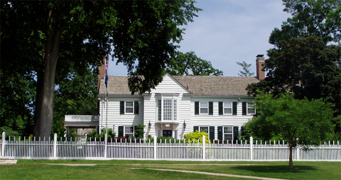
Eastcliff
Monument and historic site · National Register of Historic Places · 3.1 mi
Historic house in St. Paul, Minnesota

Fire Station No. 19
Monument and historic site · National Register of Historic Places · 2.7 mi
Former fire station in Minneapolis, Minnesota, United States
Heman Gibbs Farmstead
Monument and historic site · National Register of Historic Places · 0.7 mi
Building in Falcon Heights, Minnesota, United States

Horatio P. Van Cleve House
Monument and historic site · National Register of Historic Places · 3.5 mi
Historic house in Minnesota, United States
49 more on the map.
Parks, trails and playgrounds53


Como Park Zoo and Conservatory
Park · National Register of Historic Places · 1.3 mi
Zoo and conservatory in Saint Paul, Minnesota, United States


Tower Hill Park
Park · National Register of Historic Places · 2.3 mi
Public park in Minneapolis, Minnesota, United States
Mississippi Gorge Regional Park
Park · 3.3 mi
Park areas in the U.S. state of Minneapolis
Reservoir Woods Park
Park · 2.6 mi
Park in Roseville, Minnesota, United States

41 more on the map.
Restaurants and cafes117

Brito's Burrito
Restaurant · Mexican · 1.4 mi
1757 Lexington Avenue North
Mo-Fr 10:00-21:00; Sa-Su 09:00-21:00

Black Coffee and Waffle Bar
Cafe · Breakfast, Brunch · 1.7 mi
1595 MN-36, Roseville
Mo-Th 11:00-19:00; Fr-Sa 11:00-20:00; Su 11:00-18:00
Caribou Coffee
Cafe · Coffee Shop · 1.4 mi
1127 Larpenteur Avenue West, Roseville
Mo-Th 05:30-20:30; Fr 05:30-21:00; Sa 06:00-20:00; Su 06:00-20:30
Centro Roseville
Restaurant · Mexican · 1.6 mi
1901 MN 36, Roseville
Su-Th 11:00-22:00; Fr-Sa 11:00-24:00

Dock & Paddle at Como Lakeside Pavilion
Diner · American · 1.6 mi
1360 Lexington Parkway North
Sa-Su 09:00-17:00; Fr 11:00-19:00
Ichiddo Ramen
Restaurant · Japanese · 1.3 mi
2100 Snelling Avenue North, Roseville
Mo-Th 11:00-21:00; Fr-Sa 11:30-22:00; Su 11:30-21:00
Key's Cafe
Restaurant · Breakfast, Brunch, American, Coffee, Pie, Cookie, Cake · 1.4 mi
1682 Lexington Avenue North, Roseville
Mo-Tu 06:30-20:00; We-Fr 06:30-21:00; Sa 07:00-21:00; Su 07:00-20:00
Lanna Thai
Restaurant · Thai · 1.1 mi
2295 Como Avenue, Saint Paul
Mo-Th 11:00-21:00, Fr-Sa 11:00-22:00, Su 11:00-20:00
Mi-Sant Kitchen & Bakery
Restaurant · Vietnamese · 1.6 mi
1881 Highway 36, Roseville
Mo-Sa 09:00-20:00
Original Malt Shop
Restaurant · American, Ice Cream · 1.4 mi
1125 Larpenteur Avenue West, Roseville
Mo-Th 11:00-20:00; Fr-Sa 11:00-21:00; Su 11:30-20:00
105 more on the map.
History
Heman Gibbs settled in the 1850s near the modern intersection of Cleveland and Larpenteur Avenues. His homestead is on the National Register of Historic Places and his home is a county museum.
On September 2, 1901, then-Vice President Theodore Roosevelt first publicly used the African proverb "Speak softly and carry a big stick" in a speech at the Minnesota State Fairgrounds, which was still a part of St. Paul at the time. Roosevelt became president just two weeks later, upon the assassination of William McKinley, and built the phrase into his concept of Big Stick Diplomacy.
Between the 1910s and 1930s, Curtiss Northwest Airport was located at the intersection of Snelling and Larpenteur Avenues. The airfield was important in Minnesota aviation history, hosting Charles Lindbergh, Speed Holman, and Phoebe Fairgrave. Part of the land is now a city park named Curtiss Field.
In the 1930s, a real estate agent named Faulkner developed land owned by a 3M executive and named this development—Falcon Heights—after himself. The first house arose in 1937.
In 1949 residents rejected annexation by Roseville or St. Paul, and voted to incorporate themselves. The expanded Falcon Heights included the University of Minnesota Golf Course and Test Fields as well as the Minnesota State Fairgrounds. Two-thirds of Falcon Heights is public land, chiefly the university and state fair (Minnesota State Fair).
From the History section of Falcon Heights, Minnesota on Wikipedia, under CC BY-SA 4.0.
Where to stay1
Churches and places of worship25
Church of St. Agnes
Church · National Register of Historic Places · 3.2 mi
Church of St. Bernard
Church · National Register of Historic Places · 3.4 mi
First Congregational Church
Church · National Register of Historic Places · 3.3 mi
Grace Evangelical Lutheran Church
Church · National Register of Historic Places · 2.9 mi
Norway Lutheran Church
Church · National Register of Historic Places · 1.0 mi
Pilgrim Baptist Church
Church · National Register of Historic Places · 3.2 mi
Saint Anthony Park United Church of Christ
Church · United Church Of Christ · 0.9 mi
2129 Commonwealth Avenue, Saint Paul
Centennial United Methodist Church
Church · United Methodist · 1.1 mi
2200 West Hillside Avenue, Saint Paul
Shopping40
Gas and EV charging9
Schools, colleges and libraries55
Healthcare10
American Academy of Health and Wellness
Clinic and pharmacy · 1.6 mi
2233 Hamline Avenue North, Roseville
Medical Aid East
Clinic and pharmacy · 0.5 mi
1424 Cosgrove Street, Falcon Heights
Map of Falcon Heights
250 places. The map loads OpenStreetMap tiles when you open it.
Climate by month
Monthly table
| Month | High | Low | Rain | Snow |
|---|---|---|---|---|
| Jan | 21°F | 6°F | 0.7 in | 8.3 in |
| Feb | 26°F | 9°F | 0.8 in | 12.3 in |
| Mar | 39°F | 22°F | 1.6 in | 4.0 in |
| Apr | 55°F | 36°F | 3.0 in | 2.1 in |
| May | 67°F | 48°F | 4.2 in | 0.0 in |
| Jun | 77°F | 58°F | 4.6 in | 0.0 in |
| Jul | 81°F | 63°F | 4.5 in | 0.0 in |
| Aug | 79°F | 60°F | 4.5 in | 0.0 in |
| Sep | 71°F | 52°F | 3.3 in | 0.0 in |
| Oct | 57°F | 39°F | 2.9 in | 0.5 in |
| Nov | 40°F | 25°F | 1.5 in | 3.0 in |
| Dec | 26°F | 12°F | 1.1 in | 10.2 in |
U.S. Climate Normals 1991-2020 for U Of Mn St Paul (0 mi away), NOAA NCEI.
People and cost of living
American Community Survey 5-year estimates, 2020-2024, U.S. Census Bureau. Estimates have margins of error, larger for small towns.
Disaster history
Ramsey County has had 10 federal disaster declarations since 2000, most often for floods.
- 2020-04-07: Covid-19 Pandemic (Biological)
- 2020-03-13: Covid-19 (Biological)
- 2019-06-12: Severe Winter Storm, Straight-Line Winds, And Flooding (Flood)
- 2014-07-21: Severe Storms, Straight-Line Winds, Flooding, Landslides, And Mudslides (Flood)
- 2011-05-10: Severe Storms And Flooding (Flood)
- 2010-04-19: Flooding (Flood)
OpenFEMA disaster declarations summaries.
Getting there and nearby towns
St. Paul Downtown Airport (STP) is the nearest airport with scheduled flights listed in OpenStreetMap, 7 miles away.
- Roseville 2 mi northeast, about 3 min by car
- St. Paul 4 mi southeast, about 7 min by car
- Minneapolis 5 mi west, about 8 min by car
- Little Canada 5 mi northeast, about 8 min by car
- Columbia Heights 5 mi northwest, about 9 min by car
- New Brighton 6 mi north, about 10 min by car
- Arden Hills 6 mi north, about 9 min by car
- Shoreview 7 mi north, about 11 min by car
- Maplewood 7 mi east, about 12 min by car
- West St. Paul 7 mi southeast, about 12 min by car
Drive times are estimates from straight-line distance, not routes.
Local news
Headlines from INDB, the NEMICO news database.
Reviews, tips and questions
Loading what members have shared...
Sources and licences
- NCES EDGE (Public domain): public schools
- NOAA NCEI U.S. Climate Normals 1991-2020 (Public domain): climate by month
- OpenFEMA (Public domain): disaster declarations
- OpenStreetMap contributors (ODbL 1.0): places, airports, map data
- U.S. Census Bureau (Public domain): population, income, housing, education, commute
- Wikidata (CC0 1.0): elevation, founding date, time zone, website, landmarks and historic places
- Wikimedia Commons (see each image): photos
- Wikipedia (CC BY-SA 4.0): overview and history text
Photo credits
- Larpenteur Avenue in Falcon Heights, Runner1928, CC BY-SA 3.0
- Bockman Hall, McGhiever, CC BY-SA 3.0
- Franklin Avenue Bridge Minneapolis, Mulad, Public domain
- Como Park Zoo and Conservatory-2006, RxS at English Wikipedia, Public domain
- Bridge L-5853 restored, McGhiever, CC BY-SA 4.0
- Cedar Avenue Bridge Minneapolis, Unknown author, Public domain
- Church of St Agnes 2013, McGhiever, CC BY-SA 3.0
- B. O. Cutter House, McGhiever, CC BY-SA 4.0
- 1stcongchurch, Appraiser, CC BY-SA 4.0
- Muskego3, Appraiser, CC BY-SA 4.0
- Horatio P. Van Cleve House, McGhiever, CC BY-SA 3.0
- Church of St Bernard, McGhiever, CC BY-SA 4.0
- Grace University Lutheran Church Minneapolis 20, AlexiusHoratius, CC BY-SA 3.0
- Casiville Bullard House, McGhiever, CC BY-SA 3.0
- Eastcliff, RxS at English Wikipedia, Public domain
- BandanaSq, RxS at English Wikipedia, Public domain
- Fire Station No. 19, McGhiever, CC BY-SA 4.0
- Dr Ward Beebe House 2013, McGhiever, CC BY-SA 3.0
- Andrew R. McGill House 2020, McGhiever, CC BY-SA 4.0
- Minnesota Governor's Residence, Unknown author, Public domain
- St. Anthony Park Branch Library, McGhiever, CC BY 4.0
- Pilgrim Baptist Church, St Paul, McGhiever, CC BY 4.0
- 2023-0929 Malcolm Willey House, Bobak Ha'Eri, CC BY 3.0
- Woodbury Fisk House, McGhiever, CC BY-SA 4.0
- Northrop Mall - panoramio, Jon Platek, CC BY-SA 3.0
- Tower Hill Park from University Avenue and Malcolm Avenue, Minneapolis, Runner1928, CC BY-SA 4.0
- Triune Masonic Temple 2013, McGhiever, CC BY-SA 3.0
- Minnesota State Fair 2017 - ticket booth 03, Runner1928, CC BY-SA 4.0
- President's Day - Flickr - Crown Star Images, Greg Gjerdingen from Willmar, USA, CC BY 2.0
- 1961 Oldsmobile Starfire Convertible (35559286495), Greg Gjerdingen from Willmar, USA, CC BY 2.0
- 1961 Oldsmobile Starfire Convertible (35571292545), Greg Gjerdingen from Willmar, USA, CC BY 2.0
- 1961 Oldsmobile Starfire Convertible (34708292784), Greg Gjerdingen from Willmar, USA, CC BY 2.0
- 1969 AMC Rebel SST (29782000240), Greg Gjerdingen from Willmar, USA, CC BY 2.0
- 1984 Buick Regal - 46886971875 (cropped), Greg Gjerdingen, CC BY 2.0
- 1984 Buick Regal - 46886971875, Greg Gjerdingen, CC BY 2.0
- 1984 Buick Regal, Greg Gjerdingen, CC BY 2.0
- 1960 AMC Rambler American (35381702172), Greg Gjerdingen from Willmar, USA, CC BY 2.0
- 1941 Willys (34779841024), Greg Gjerdingen from Willmar, USA, CC BY 2.0
- 1960 AMC Rambler American (35162933320), Greg Gjerdingen from Willmar, USA, CC BY 2.0
- 1969 AMC Rebel SST (29449761974), Greg Gjerdingen from Willmar, USA, CC BY 2.0


Page built October 30, 2026. Spotted a mistake? Tell us or suggest a place.