


Why visit Grant
Townapedia lists 24 museums and landmarks, 67 parks and trails, 12 places to eat, 2 places to stay and 6 attractions in and around town.
Highlights include Point Douglas-St. Louis River Road Bridge, Bridge No. 5721, Albert Lammers House and Captain Austin Jenks House.
July is the warmest month, with average highs of 79°F; January lows average 5°F.
Weather in Grant
Forecast from the National Weather Service. Full forecast
About Grant
Grant is a city in Washington County, Minnesota. The population was 3,966 at the 2020 census.
From the Wikipedia article Grant, Minnesota (this version), under CC BY-SA 4.0.
Things to do6

Point Douglas-St. Louis River Road Bridge
Bridge · National Register of Historic Places · 4.0 mi
Road bridge in Stillwater Township, Minnesota
Bridge No. 5721
Bridge · National Register of Historic Places · 2.7 mi
Bridge in United States of America

Stillwater Bridge
Bridge · National Register of Historic Places · 5.5 mi
Vertical-lift bridge connecting Stillwater, Minnesota and Houlton, Wisconsin over the St. Croix River

Wildwood Amusement Park
Monument and historic site · 2.9 mi
Former amusement park and picnic grounds in Mahtomedi, Minnesota, United States


Museums and landmarks24

Albert Lammers House
Monument and historic site · National Register of Historic Places · 5.7 mi
House in Stillwater, Minnesota

Captain Austin Jenks House
Monument and historic site · National Register of Historic Places · 5.4 mi
Historic house in Minnesota, United States

Charles P. Noyes Cottage
Monument and historic site · National Register of Historic Places · 4.5 mi
Building in White Bear Lake, Minnesota, United States
Chicago, Milwaukee and St. Paul Freight House
Monument and historic site · National Register of Historic Places · 5.5 mi
Railway station in Stillwater, the United States of America

Cyrus B. Cobb House
Monument and historic site · National Register of Historic Places · 4.7 mi
White Bear Lake, Minnesota

E. H. Hobe House-Solheim
Monument and historic site · National Register of Historic Places · 6.0 mi
Historic house in Minnesota, United States

First National Bank of White Bear
Monument and historic site · National Register of Historic Places · 4.8 mi
Building in White Bear Lake, Minnesota, United States
Henry Stussi House
Monument and historic site · National Register of Historic Places · 3.2 mi
Historic house in Minnesota, United States

Isaac Staples' Sawmill
Monument and historic site · National Register of Historic Places · 5.3 mi
Historic building in Stillwater, Minnesota, United States
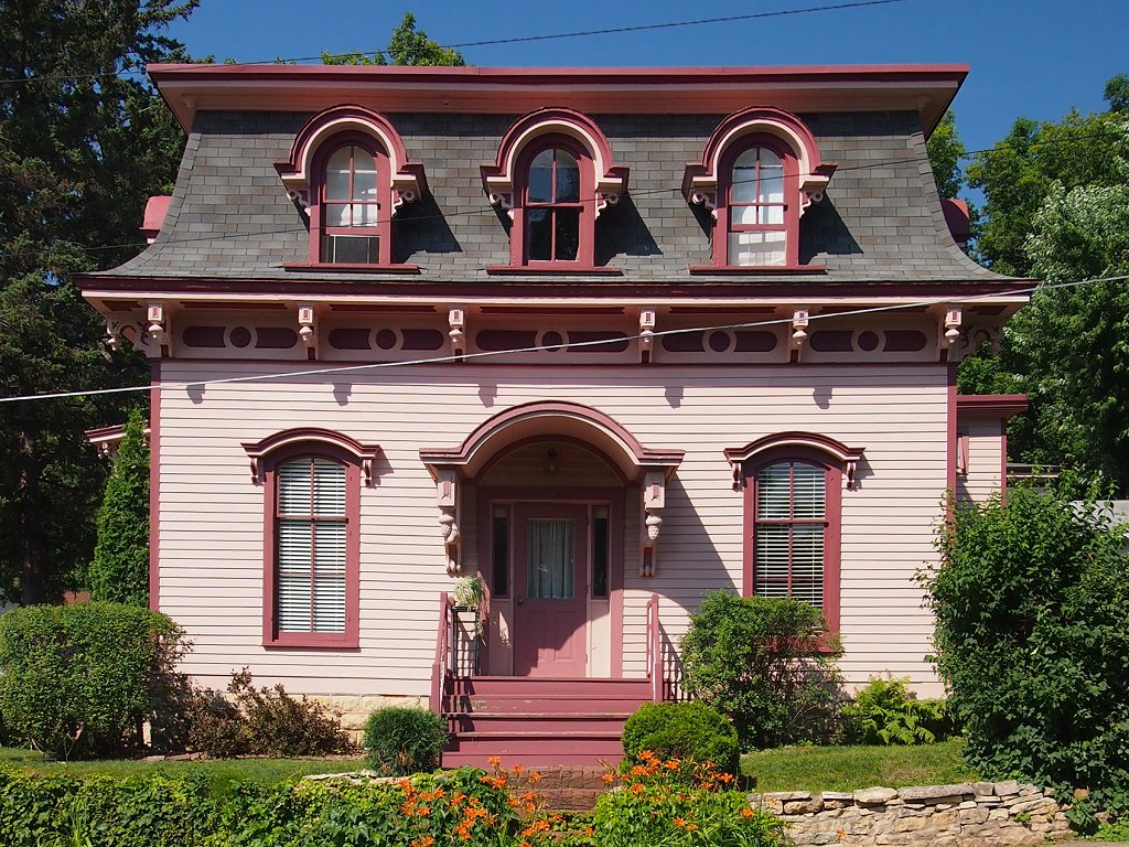
Ivory McKusick House
Monument and historic site · National Register of Historic Places · 5.2 mi
Historic house in Minnesota, United States
Minnesota Territorial Prison
Monument and historic site · National Register of Historic Places · 5.3 mi
Former prison in Stillwater, Minnesota

Moritz Bergstein Shoddy Mill and Warehouse
Monument and historic site · National Register of Historic Places · 5.8 mi
Building in Stillwater, Minnesota, United States
12 more on the map.
Parks, trails and playgrounds67




55 more on the map.
Restaurants and cafes12






History
The city was named for President Ulysses S. Grant. From time to time, western villages in Grant Township separated as incorporated cities. Grant Township incorporated itself as the City of Grant in November 1996.
From the History section of Grant, Minnesota on Wikipedia, under CC BY-SA 4.0.
Where to stay2
Churches and places of worship6
Shopping1
Gas and EV charging2
Schools, colleges and libraries42
Healthcare2
Map of Grant
164 places. The map loads OpenStreetMap tiles when you open it.
Climate by month
Monthly table
| Month | High | Low | Rain |
|---|---|---|---|
| Jan | 22°F | 5°F | 0.8 in |
| Feb | 28°F | 8°F | 0.9 in |
| Mar | 41°F | 20°F | 1.6 in |
| Apr | 55°F | 34°F | 3.0 in |
| May | 67°F | 47°F | 4.2 in |
| Jun | 76°F | 58°F | 4.8 in |
| Jul | 79°F | 62°F | 4.4 in |
| Aug | 78°F | 60°F | 4.4 in |
| Sep | 71°F | 51°F | 3.3 in |
| Oct | 58°F | 38°F | 2.7 in |
| Nov | 41°F | 25°F | 1.8 in |
| Dec | 28°F | 12°F | 1.2 in |
U.S. Climate Normals 1991-2020 for Stillwater 2Sw (4 mi away), NOAA NCEI.
People and cost of living
American Community Survey 5-year estimates, 2020-2024, U.S. Census Bureau. Estimates have margins of error, larger for small towns.
Disaster history
Washington County has had 8 federal disaster declarations since 2000, most often for floods.
- 2020-04-07: Covid-19 Pandemic (Biological)
- 2020-03-13: Covid-19 (Biological)
- 2019-06-12: Severe Winter Storm, Straight-Line Winds, And Flooding (Flood)
- 2011-05-10: Severe Storms And Flooding (Flood)
- 2010-03-19: Flooding (Flood)
- 2005-09-13: Hurricane Katrina Evacuation (Hurricane)
OpenFEMA disaster declarations summaries.
Getting there and nearby towns
St. Paul Downtown Airport (STP) is the nearest airport with scheduled flights listed in OpenStreetMap, 12 miles away.
- Dellwood 3 mi northwest, about 5 min by car
- Stillwater 4 mi east, about 7 min by car
- White Bear Lake 5 mi west, about 8 min by car
- Hugo 6 mi northwest, about 10 min by car
- North St. Paul 6 mi southwest, about 10 min by car
- Lake Elmo 7 mi south, about 10 min by car
- Oakdale 7 mi south, about 11 min by car
- Maplewood 7 mi southwest, about 12 min by car
- Vadnais Heights 8 mi west, about 13 min by car
- Bayport 8 mi southeast, about 13 min by car
Drive times are estimates from straight-line distance, not routes.
Local news
Headlines from INDB, the NEMICO news database.
Reviews, tips and questions
Loading what members have shared...
Sources and licences
- NCES EDGE (Public domain): public schools
- NOAA NCEI U.S. Climate Normals 1991-2020 (Public domain): climate by month
- OpenFEMA (Public domain): disaster declarations
- OpenStreetMap contributors (ODbL 1.0): places, airports, map data
- U.S. Census Bureau (Public domain): population, income, housing, education, commute
- Wikidata (CC0 1.0): elevation, founding date, time zone, website, landmarks and historic places
- Wikimedia Commons (see each image): photos
- Wikipedia (CC BY-SA 4.0): overview and history text
Photo credits
- Pt Douglas-St Louis River Road Bridge, McGhiever, CC BY-SA 4.0
- Bridge No. 5721, McGhiever, CC BY-SA 3.0
- Henry Stussi House, McGhiever, CC BY-SA 4.0
- Isaac Staples Sawmill, McGhiever, CC BY-SA 4.0
- Moritz Bergstein Shoddy Mill & Warehouse, McGhiever, CC BY-SA 4.0
- Freight House 1, Elkman, CC BY-SA 3.0
- Cyrus Cobb House resized, Elkman, CC BY-SA 3.0
- Roscoe Hersey 1, Elkman, CC BY-SA 3.0
- First National Bank of White Bear, McGhiever, CC BY-SA 4.0
- Pest House, McGhiever, CC BY-SA 4.0
- Stillwater Minnesota, Autoshade~commonswiki, Public domain
- Downtown Stillwater Main St N 100 block, McGhiever, CC BY-SA 4.0
- Nelson School 2015, McGhiever, CC BY-SA 4.0
- E. H. Hobe House, McGhiever, CC BY-SA 3.0
- Ivory McKusick House, McGhiever, CC BY-SA 3.0
- Capt. Austin Jenks House, McGhiever, CC BY-SA 4.0
- Boom site 4, Elkman, CC BY-SA 3.0
- Warden's House 3, Elkman, CC BY-SA 3.0
- Mortimer Webster House, McGhiever, CC BY-SA 4.0
- Albert Lammers House, McGhiever, CC BY-SA 3.0
- Stillwater Courthouse, Iulus Ascanius at English Wikipedia, Public domain
- Charles Noyes Cottage 3, Elkman, CC BY-SA 3.0
- William Sauntry House, McGhiever, CC BY-SA 3.0
- Washington County Heritage Center, Stillwater Minnesota, Heritage Preservation Department - MNHS, CC BY-SA 2.0


Page built October 30, 2026. Spotted a mistake? Tell us or suggest a place.