

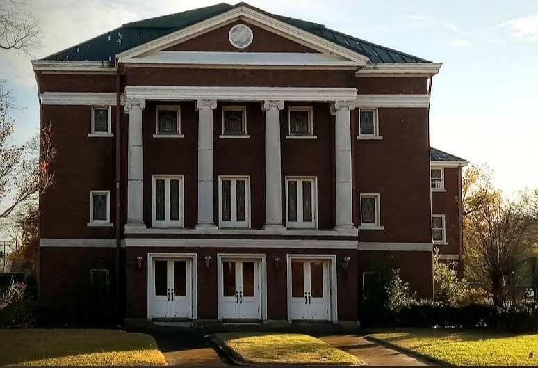


Helena-West Helena, Arkansas
Helena-West Helena is a city of 8,935 people in Phillips County, Arkansas, founded in 2006.
Why visit Helena-West Helena
Townapedia lists 53 museums and landmarks, 16 parks and trails, 16 places to eat, 8 places to stay and 3 attractions in and around town.
Highlights include Delta Cultural Center and Almer Store.
July is the warmest month, with average highs of 90°F; January lows average 32°F.
Weather in Helena-West Helena
Forecast from the National Weather Service. Full forecast
About Helena-West Helena
Helena–West Helena (; ) is the county seat of and the largest city within Phillips County, Arkansas, United States. The current city was consolidated, effective January 1, 2006, from the two Arkansas cities of Helena and West Helena. Helena is sited on lowlands between the Mississippi River and the eastern side of Crowley's Ridge. West Helena is located on the western side of Crowley's Ridge, a geographic anomaly in the typically flat Arkansas Delta.
From the Wikipedia article Helena–West Helena, Arkansas (this version), under CC BY-SA 4.0.
Things to do3


Museums and landmarks53
Delta Cultural Center
Museum · National Register of Historic Places · 2.0 mi
History museum in Helena, Arkansas
141 Cherry Street, Helena

Almer Store
Monument and historic site · National Register of Historic Places · 1.8 mi
United States historic place
824 Columbia Street, Helena
Beech Street Historic District
Monument and historic site · National Register of Historic Places · 1.5 mi
Historic district in Helena–West Helena, Arkansas

Centennial Baptist Church
Monument and historic site · Baptist · National Register of Historic Places · 1.7 mi
Church building in Arkansas, United States of America


Cherry Street Historic District
Monument and historic site · National Register of Historic Places · 2.0 mi
Historic district in Arkansas, United States
Perry Street Historic District
Monument and historic site · National Register of Historic Places · 1.8 mi
Historic district in Arkansas, United States
Temple Beth El Cemetery
Monument and historic site · National Register of Historic Places · 2.0 mi
Cemetery in Helena, Arkansas
Allin House
Monument and historic site · National Register of Historic Places · 1.6 mi
United States historic place
Altman House
Monument and historic site · National Register of Historic Places · 1.3 mi
United States historic place
Chicago Mill Company Office Building
Monument and historic site · National Register of Historic Places · 2.2 mi
Office building in Helena-West Helena, United States of America
Coolidge House
Monument and historic site · National Register of Historic Places · 1.5 mi
Historic house in Arkansas, United States
Denison House
Monument and historic site · National Register of Historic Places · 1.5 mi
Listed on the NRHP in Arkansas
41 more on the map.
Parks, trails and playgrounds16

Freeman Playground
Playground · 1.6 mi
The mission of the Freeman Playground is to provide children and families of all ability levels with a safe, healthy, and fun place to play.
803 Beech Street, Helena-West Helena



4 more on the map.
Restaurants and cafes16




Sonic
Fast food · Burger · 2.8 mi
849 North Sebastian Street, West Helena
Mo-Sa 06:00-23:00; Su 07:00-23:00
Subway
Fast food · Sandwich · 2.6 mi
770 North Sebastion Street, West Helena
Mo-Th 09:00-22:00; Fr-Sa 09:00-23:00; Su 09:00-22:00
Taco Bell
Fast food · Tex-Mex · 2.5 mi
761 North Sebastian Street, West Helena
Mo-Th 10:00-01:00; Fr-Sa 10:00-02:00; Su 10:00-01:00
4 more on the map.
History
The area comprising modern downtown Helena, next to the Mississippi River, was originally part of a land speculation deal between Sylvanus Phillips (the county's namesake) and St. Louis businessman William Russell in around 1815. Phillips had lived in the area as early as 1797, and moved to the area of Helena following a brief stint at Arkansas Post in 1799. The land was formally platted by New York surveyor Nicholas Rightor in 1820, and by 1833, the city of Helena was founded. Local legend holds that the town was named are the deceased daughter of Sylvanus.
Like other river towns in the Arkansas Delta (such at Hopefield, Osceola, and Napoleon) Helena became known as a place that attracted thieves, gamblers, and other outlaws who inhabited frontier America. In 1834, British geologist George William Featherstonhaugh was appointed by the War Department to make a geological survey of the state of Arkansas. Before the trip, while stopping in Bolivar, TN, Featherstonhaugh was warned against going to Helena, it being described by the locals as "a sink of crime and infamy."
From the History section of Helena–West Helena, Arkansas on Wikipedia, under CC BY-SA 4.0.
Where to stay8
Isle Casino Hotel Lula Hotel & Casino - A Caesars Rewards Destination
Motel and hotel · 3.2 mi
777 Isle of Capri Pkwy, Lula
Churches and places of worship25
New Light Missionary Baptist Church
Church · National Register of Historic Places · 1.8 mi
Saint Mary Catholic Church
Church · Roman Catholic · 1.7 mi
123 Columbia Street, Helena
Carter Chapel
Church · African Methodist Episcopal · 1.7 mi
515 Columbia Street, Helena
First United Methodist Church
Church · Methodist · 1.8 mi
502 Porter Street, Helena
Shopping5
Gas and EV charging3
Schools, colleges and libraries16
Healthcare1
Map of Helena-West Helena
146 places. The map loads OpenStreetMap tiles when you open it.
Climate by month
Monthly table
| Month | High | Low | Rain | Snow |
|---|---|---|---|---|
| Jan | 49°F | 32°F | 4.6 in | 0.2 in |
| Feb | 54°F | 35°F | 4.2 in | 0.0 in |
| Mar | 63°F | 43°F | 5.0 in | 0.0 in |
| Apr | 73°F | 52°F | 5.7 in | 0.0 in |
| May | 81°F | 62°F | 4.9 in | 0.0 in |
| Jun | 88°F | 70°F | 3.5 in | 0.0 in |
| Jul | 90°F | 73°F | 3.4 in | 0.0 in |
| Aug | 90°F | 72°F | 2.8 in | 0.0 in |
| Sep | 85°F | 65°F | 2.6 in | 0.0 in |
| Oct | 74°F | 52°F | 3.5 in | 0.0 in |
| Nov | 62°F | 42°F | 4.4 in | 0.0 in |
| Dec | 52°F | 35°F | 5.1 in | 0.1 in |
U.S. Climate Normals 1991-2020 for Helena (2 mi away), NOAA NCEI.
People and cost of living
American Community Survey 5-year estimates, 2020-2024, U.S. Census Bureau. Estimates have margins of error, larger for small towns.
Disaster history
Phillips County has had 13 federal disaster declarations since 2000, most often for severe storms.
- 2026-01-24: Severe Winter Storm (Winter Storm)
- 2025-04-05: Severe Storms, Tornadoes, And Flooding (Severe Storm)
- 2020-08-27: Hurricane Laura (Hurricane)
- 2020-07-10: Severe Storms And Straight-Line Winds (Tornado)
- 2020-04-03: Covid-19 Pandemic (Biological)
- 2020-03-13: Covid-19 (Biological)
OpenFEMA disaster declarations summaries.
Getting there and nearby towns
Thompson-Robbins Airport (HEE) is the nearest airport with scheduled flights listed in OpenStreetMap, 4 miles away.
- Marvell 17 mi west, about 27 min by car
- Marianna 19 mi northwest, about 30 min by car
- Clarksdale 24 mi south, about 38 min by car
- Tunica Resorts 26 mi northeast, about 43 min by car
- Marks 28 mi southeast, about 44 min by car
- Forrest City 35 mi north, about 56 min by car
- Senatobia 37 mi east, about 59 min by car
- Hernando 42 mi northeast, about 1 h by car
- Horn Lake 44 mi northeast, about 1 h 15 min by car
- Southaven 47 mi northeast, about 1 h 15 min by car
Drive times are estimates from straight-line distance, not routes.
Local news
Headlines from INDB, the NEMICO news database.
Reviews, tips and questions
Loading what members have shared...
Sources and licences
- NCES EDGE (Public domain): public schools
- NOAA NCEI U.S. Climate Normals 1991-2020 (Public domain): climate by month
- OpenFEMA (Public domain): disaster declarations
- OpenStreetMap contributors (ODbL 1.0): places, airports, map data
- U.S. Census Bureau (Public domain): population, income, housing, education, commute
- Wikidata (CC0 1.0): elevation, founding date, time zone, website, landmarks and historic places
- Wikimedia Commons (see each image): photos
- Wikipedia (CC BY-SA 4.0): overview and history text
Photo credits
- Helena-West Helena collage, Brandonrush, CC BY-SA 3.0
- First Presbyterian Church Helena-West Helena, Haze Haven, CC BY-SA 4.0
- Delta Cultural Center-HelenaAR, Unknown author, Public domain
- Helena AR 2012-04-01 015, Thomas R Machnitzki ([email protected]), CC BY 3.0
- DowntownHelenabluesfest, Joshczupryk at English Wikipedia, Public domain
- Centennial Baptist Church, Helena-West Helena, AR, Brandonrush, CC BY-SA 3.0
- HelenaConfederateCemetary, joshczupryk, Public domain
- Helena AR 2012-04-01 012, Thomas R Machnitzki ([email protected]), CC BY 3.0
- Helena Library and Museum, Valis55, CC BY-SA 3.0
- Estevan Hall, Valis55, CC BY-SA 3.0
- Federal Building-United States Post Office and Court House, Helena, AR, Valis55, CC BY-SA 3.0
- Faust House, Helena-West Helena, AR, Brandonrush, CC BY-SA 3.0
- Maple Hill Cemetery Helena AR 002, Thomas R Machnitzki ([email protected]), CC BY 3.0
- William A. Short House, Valis55, CC BY-SA 3.0
- Pillow House, Helena-West Helena, AR, Brandonrush, CC BY-SA 3.0
- Myers House, Helena-West Helena, AR, Brandonrush, CC BY-SA 3.0
- Horner House, Helena-West Helena, AR, Brandonrush, CC BY-SA 3.0
- Helena AR 011, Thomas R Machnitzki ([email protected]), CC BY 3.0
- Gemmill-Faust House, Valis55, CC BY-SA 3.0
- Nelson House, Helena, AR, Valis55, CC BY-SA 3.0
- Moore-Hornor House, Valis55, CC BY-SA 3.0
- White House, Helena, AR, Valis55, CC BY-SA 3.0
- Battery B Site, Battle of Helena, Valis55, CC BY-SA 3.0
- Battery B Site, Battle of Helena, Historical Marker, Valis55, CC BY-SA 3.0
- Altman House, Valis55, CC BY-SA 3.0
- Beech Street Historic District, 7 of 9, Valis55, CC BY-SA 3.0
- Beech Street Historic District, 4 of 9, Valis55, CC BY-SA 3.0
- Beech Street Historic District, 9 of 9, Valis55, CC BY-SA 3.0
- Beech Street Historic District, 8 of 9, Valis55, CC BY-SA 3.0
- Beech Street Historic District, 1 of 9, Valis55, CC BY-SA 3.0
- Beech Street Historic District, 5 of 9, Valis55, CC BY-SA 3.0
- Beech Street Historic District, 2 of 9, Valis55, CC BY-SA 3.0
- Beech Street Historic District, 6 of 9, Valis55, CC BY-SA 3.0
- Beech Street Historic District, 3 of 9, Valis55, CC BY-SA 3.0
- James C. Tappan House, Valis55, CC BY-SA 3.0
- Denison House, Valis55, CC BY-SA 3.0
- Coolidge House, Valis55, CC BY-SA 3.0
- W.H. Grey Grave & Memorial, Haze Haven, CC BY-SA 4.0
- E.S. Ready House, Valis55, CC BY-SA 3.0
- West House, Helena, AR, Valis55, CC BY-SA 3.0


Page built October 30, 2026. Spotted a mistake? Tell us or suggest a place.