


Hudson, Massachusetts
Hudson is a community of 15,719 people in Middlesex County, Massachusetts.
Why visit Hudson
Townapedia lists 32 museums and landmarks, 44 parks and trails, 56 places to eat, 1 place to stay and 17 attractions in and around town.
Highlights include Taylor Memorial Bridge, Addition Hill, Berlin Town Hall and Bolton Center Historic District.
July is the warmest month, with average highs of 87°F; January lows average 15°F.
Weather in Hudson
Forecast from the National Weather Service. Full forecast
About Hudson
Hudson is a census-designated place (CDP) comprising the densely developed central part of the town of Hudson in Middlesex County, Massachusetts, United States. The population of the CDP was 15,749 at the 2020 census, out of 20,092 in the entire town.
From the Wikipedia article Hudson (CDP), Massachusetts (this version), under CC BY-SA 4.0.
Things to do17

Taylor Memorial Bridge
Bridge · 0.7 mi
Pedestrian bridge in Hudson, Massachusetts

5 more on the map.
Museums and landmarks32

Berlin Town Hall
Monument and historic site · National Register of Historic Places · 3.7 mi
Town hall in Berlin, Massachusetts, United States

Bolton Center Historic District
Monument and historic site · National Register of Historic Places · 3.6 mi
Historic district in Massachusetts, United States
Brigham Cemetery
Monument and historic site · National Register of Historic Places · 3.5 mi
Historic cemetery in Marlborough, Massachusetts, United States
Brown–Stow House
Monument and historic site · National Register of Historic Places · 3.6 mi
Building in Massachusetts, United States
Bullard House
Monument and historic site · National Register of Historic Places · 3.8 mi
Historic house in Massachusetts, United States
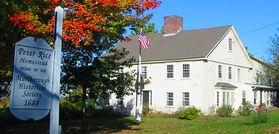
Capt. Peter Rice House
Monument and historic site · National Register of Historic Places · 3.1 mi
Building in Massachusetts, United States

Colonel Adelbert Mossman House
Monument and historic site · National Register of Historic Places · 0.6 mi
Historic house in Massachusetts, United States
Goodale Homestead
Monument and historic site · National Register of Historic Places · 3.2 mi
Building in Massachusetts, United States

Hapgood House
Monument and historic site · National Register of Historic Places · 3.4 mi
Building in Massachusetts, United States


John Cotting House
Monument and historic site · National Register of Historic Places · 3.3 mi
Building in Massachusetts, United States
Maplewood Cemetery
Monument and historic site · National Register of Historic Places · 2.7 mi
Cemetery in Marlborough, Massachusetts
Marlborough Center Historic District
Monument and historic site · National Register of Historic Places · 3.2 mi
Historic district in Massachusetts, United States
20 more on the map.
Parks, trails and playgrounds44




32 more on the map.
Restaurants and cafes56

Bolton Street Tavern
Restaurant · Pub · 1.9 mi
587 Bolton Street, Marlborough
Mo-We 11:00-24:00; Th 11:00-01:00; Fr-Sa 11:00-02:00; Su 10:00-24:00

Wild Hare Café, Restaurant & Brewery
Cafe · Coffee Shop, Bakery, Breakfast, Lunch, Sandwich, Salad, Pastry
43 Broad Street, Hudson
Tu-Su 07:00-15:00

Medusa Brewing Company
Bar and pub
111 Main Street, Hudson
Tu-Th 15:00-22:00; Fr-Sa 12:00-22:00; Su 12:00-20:00


The Vintage Cafe
Cafe
246 Main Street
We-Fr 07:30-14:30; Sa,Su 08:30-14:30
Clover Road Brewing
Bar and pub
Tu-We 16:00-21:30; Th 16:00-22:30; Fr 15:00-22:30; Sa 12:00-22:30;...
44 more on the map.
Where to stay1
Churches and places of worship11
Shopping15
Gas and EV charging11
Schools, colleges and libraries35
Advanced Math And Science Academy Charter School
School · 4.1 mi
201 Forest Street, Marlborough
Assabet Valley Vocational High School
School · 1.7 mi
215 Fitchburg Street, Marlborough
Healthcare3
Map of Hudson
225 places. The map loads OpenStreetMap tiles when you open it.
Climate by month
Monthly table
| Month | High | Low | Rain |
|---|---|---|---|
| Jan | 37°F | 15°F | 3.6 in |
| Feb | 41°F | 16°F | 3.3 in |
| Mar | 48°F | 24°F | 4.6 in |
| Apr | 62°F | 34°F | 4.4 in |
| May | 73°F | 45°F | 3.7 in |
| Jun | 81°F | 55°F | 4.2 in |
| Jul | 87°F | 60°F | 4.0 in |
| Aug | 85°F | 58°F | 4.4 in |
| Sep | 78°F | 49°F | 3.9 in |
| Oct | 66°F | 38°F | 5.1 in |
| Nov | 54°F | 29°F | 3.8 in |
| Dec | 43°F | 21°F | 4.8 in |
U.S. Climate Normals 1991-2020 for Maynard 2 (7 mi away), NOAA NCEI.
People and cost of living
American Community Survey 5-year estimates, 2020-2024, U.S. Census Bureau. Estimates have margins of error, larger for small towns.
Disaster history
Middlesex County has had 26 federal disaster declarations since 2000, most often for severe storms.
- 2023-09-15: Hurricane Lee (Hurricane)
- 2020-03-27: Covid-19 Pandemic (Biological)
- 2020-03-13: Covid-19 (Biological)
- 2018-07-19: Severe Winter Storm And Snowstorm (Snowstorm)
- 2015-04-13: Severe Winter Storm, Snowstorm, And Flooding (Severe Storm)
- 2013-04-19: Severe Winter Storm, Snowstorm, And Flooding (Severe Storm)
OpenFEMA disaster declarations summaries.
Getting there and nearby towns
Minute Man Airfield (MMN) is the nearest airport with scheduled flights listed in OpenStreetMap, 6 miles away.
- Framingham 9 mi southeast, about 14 min by car
- Worcester 15 mi southwest, about 24 min by car
- Fitchburg 19 mi northwest, about 31 min by car
- Belmont 20 mi east, about 31 min by car
- Burlington 20 mi northeast, about 32 min by car
- Lowell 21 mi northeast, about 34 min by car
- Arlington 21 mi east, about 33 min by car
- Brookline 22 mi east, about 36 min by car
- Dedham 22 mi southeast, about 36 min by car
- Cambridge 23 mi east, about 37 min by car
Drive times are estimates from straight-line distance, not routes.
Local news
Headlines from INDB, the NEMICO news database.
Reviews, tips and questions
Loading what members have shared...
Sources and licences
- NCES EDGE (Public domain): public schools
- NOAA NCEI U.S. Climate Normals 1991-2020 (Public domain): climate by month
- OpenFEMA (Public domain): disaster declarations
- OpenStreetMap contributors (ODbL 1.0): places, airports, map data
- U.S. Census Bureau (Public domain): population, income, housing, education, commute
- Wikidata (CC0 1.0): elevation, founding date, time zone, website, landmarks and historic places
- Wikimedia Commons (see each image): photos
- Wikipedia (CC BY-SA 4.0): overview and history text
Photo credits
- Hudson Town Hall, Marcbela (Marc N. Belanger), Public domain
- Mass Central Rail Trail, Hudson MA, John Phelan, CC BY-SA 4.0
- Assabet River Rail Trail, Hudson MA, John Phelan, CC BY-SA 3.0
- Lancaster Railroad Trestle, Mill Pond, Hudson, MA 001, Unknown author Unknown author, Public domain
- Hudson station building (1), May 2017, Pi.1415926535, CC BY-SA 3.0
- Hudson station building (2), May 2017, Pi.1415926535, CC BY-SA 3.0
- Hudson station building (3), May 2017, Pi.1415926535, CC BY-SA 3.0
- ARRT bridge in Hudson (1), March 2022, Pi.1415926535, CC BY-SA 4.0
- Wood Square, Hudson, with streetcars - postcard, Unknown author Unknown author, Public domain
- Assabet River Rail Trail in Hudson, March 2022, Pi.1415926535, CC BY-SA 4.0
- Hudson Worsted Company rail trestle (2), March 2022, Pi.1415926535, CC BY-SA 4.0
- Hudson Worsted Company rail trestle (3), March 2022, Pi.1415926535, CC BY-SA 4.0
- Underside of ARRT bridge in Hudson, March 2022, Pi.1415926535, CC BY-SA 4.0
- ARRT bridge in Hudson (3), March 2022, Pi.1415926535, CC BY-SA 4.0
- The Square, Hudson Massachusetts - postcard, Unknown photographer, Public domain
- Hudson Worsted Company rail trestle (1), March 2022, Pi.1415926535, CC BY-SA 4.0
- Assabet River in Hudson west of ARRT, March 2022, Pi.1415926535, CC BY-SA 4.0
- Assabet River in Hudson east of ARRT, March 2022, Pi.1415926535, CC BY-SA 4.0
- Hudson Worsted Company mill, March 2022, Pi.1415926535, CC BY-SA 4.0
- Deck of ARRT bridge in Hudson, March 2022, Pi.1415926535, CC BY-SA 4.0
- ARRT bridge in Hudson (2), March 2022, Pi.1415926535, CC BY-SA 4.0
- Stone post, Assabet River Rail Trail, Hudson MA, John Phelan, CC BY-SA 4.0
- Caboose on the Assabet River Rail Trail in Hudson June 2026, 4300streetcar, CC BY 4.0
- Caboose, Assabet River Rail Trail, Hudson MA, John Phelan, CC BY-SA 4.0
- Central Mass Branch tracks in Hudson, March 2022, Pi.1415926535, CC BY-SA 4.0
- Assabet River Rail Trail south of Washington St, Hudson MA, John Phelan, CC BY 3.0
- Stone marker, Assabet River Rail Trail, Hudson MA, John Phelan, CC BY-SA 4.0
- Pan Burying Ground, Tim Pierce, CC BY-SA 3.0
- John Cotting House, Tim Pierce, CC BY-SA 3.0
- MarlboroughMA WeeksCemetery, User:Magicpiano, CC BY-SA 4.0
- Capt Peter Rice House, Lee Wright / Marlborough Historical Society (www.HistoricMarlborough.org), CC BY 4.0
- BoltonMA WhitcombInnAndFarm, User:Magicpiano, CC BY-SA 4.0
- Colonel Adelbert Mossman House, Tim Pierce, CC BY-SA 3.0
- MarlboroughMA SpringHillCemetery, User:Magicpiano, CC BY-SA 4.0
- MarlboroughMA PleasantStreetHD, User:Magicpiano, CC BY-SA 4.0
- Temple Building Marlborough, Marcbela (Marc N. Belanger), Public domain
- First Parish, Bolton MA, John Phelan, CC BY-SA 4.0
- Rocklawn Cemetery, Tim Pierce, CC BY-SA 3.0
- StowMA HapgoodHouse, User:Magicpiano, CC BY-SA 4.0
- Warren Block Marlborough, Marcbela (Marc N. Belanger), Public domain


Page built October 30, 2026. Spotted a mistake? Tell us or suggest a place.