


Dedham, Massachusetts
Dedham is a community of 25,237 people in Norfolk County, Massachusetts, founded in 1635.
Why visit Dedham
Townapedia lists 88 museums and landmarks, 90 parks and trails, 86 places to eat, 4 places to stay and 14 attractions in and around town.
Highlights include Blue Hills Ski Area, William James College, Bellevue Standpipe and Endicott Estate.
July is the warmest month, with average highs of 86°F; January lows average 21°F.
Weather in Dedham
Forecast from the National Weather Service. Full forecast
About Dedham
Dedham is a town in, and the county seat of, Norfolk County, Massachusetts, United States. Located on Boston's southwestern border, the population was 25,364 at the 2020 census.
From the Wikipedia article Dedham, Massachusetts (this version), under CC BY-SA 4.0.
Things to do14

Blue Hills Ski Area
Ski area · 3.8 mi
Ski area in Canton, Massachusetts

William James College
School · 3.5 mi
Private school of psychology in Newton, Massachusetts


Henderson Arts Center
Cinema and theater · 1.1 mi
Noble and Greenough School's Henderson Arts Center includes Vinik Theatre, Foster Gallery, Goins Family Dance Studio, the Smith Music...
10 Campus Drive, Dedham
2 more on the map.
Museums and landmarks88

Bellevue Standpipe
Monument and historic site · National Register of Historic Places · 2.7 mi
Water tower in Boston, Massachusetts, United States

Endicott Estate
Monument and historic site · National Register of Historic Places · 0.9 mi
Historic house in Massachusetts, United States
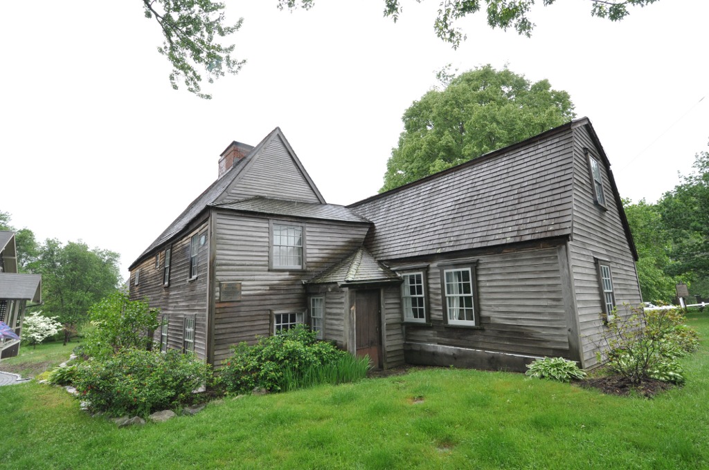
Fairbanks House
Museum · National Register of Historic Places · 0.6 mi
Circa 1637 Historic House Museum
511 East Street, Dedham

Fairview Cemetery
Monument and historic site · National Register of Historic Places · 2.0 mi
Cemetery in Hyde Park, Boston, Massachusetts

Adams-Nervine Asylum
Monument and historic site · National Register of Historic Places · 4.8 mi
Building in Massachusetts, United States
Alfred Douglass House
Monument and historic site · National Register of Historic Places · 4.8 mi
Historic house in Massachusetts, United States

Almont Apartments
Monument and historic site · National Register of Historic Places · 4.8 mi
Historic building in Boston, Massachusetts, USA
Ames Schoolhouse
Monument and historic site · National Register of Historic Places
School building in Dedham, Massachusetts
Amos Fuller House
Monument and historic site · National Register of Historic Places · 4.1 mi
House in Needham, Massachusetts
Arnold Arboretum
Monument and historic site · National Register of Historic Places · 4.6 mi
Botanical garden of the Harvard University


Benjamin Caryl House
Monument and historic site · National Register of Historic Places · 4.7 mi
Historic house in Massachusetts, United States
Blue Hill Meteorological Observatory
Monument and historic site · National Register of Historic Places · 4.1 mi
Weather observatory in Milton, United States
76 more on the map.
Parks, trails and playgrounds90


Boston Nature Center and Wildlife Sanctuary
Park · 4.7 mi
Protected Landscape in Massachusetts


78 more on the map.
Restaurants and cafes86

Boston Ale House
Diner · American · 3.0 mi
1885
Sa-Su 11:00-22:00; Mo-We 15:00-22:00; Th 15:00-23:00; Fr 11:30-23:00

Eggs & Thai Cafe
Restaurant · Thai
Hig6h St.28 High Street, Dedham
Tu-Th 11:00-21:00, Fr-Sa 11:00-21:30, Su 11:00-21:00
IHOP
Restaurant · Breakfast, Pancake · 0.8 mi
260 Providence Highway, Dedham
Mo-Th 07:00-22:00; Fr 07:00-24:00; Sa 00:00-24:00; Su 00:00-22:00
Islington Pizza
Restaurant · Pizza, Pasta · 2.0 mi
315 Washington Street
Mo-We 10:00-20:00; Th, Fr 10:00-21:00; Sa 11:00-21:00

Recreo Coffee & Roasterie
Cafe · Breakfast, Coffee Shop · 3.0 mi
1876 Centre Street, West Roxbury
Mo-Fr 07:00-16:00; Sa-Su 08:00-16:00
Talk and Wok Cafe
Restaurant · Chinese · 2.9 mi
1277 River Street, Hyde Park
Tu-Th 11:00-22:30; Fr 11:00-23:30; Sa 11:30-23:30; Su 12:00-22:30
West Napoli Pizza
Restaurant · American, Italian, Italian Pizza · 2.8 mi
1946 Centre Street
Mo-Sa 11:00-21:00
Wild Blossom
Restaurant · Chinese · 2.0 mi
301 Washington Street
Mo-Th, Su 11:00-21:45; Fr, Sa 11:00-22:45

74 more on the map.
Where to stay4
Holiday Inn Boston - Dedham Hotel & Conference Center
Motel and hotel · 1.1 mi
55 Ariadne Road, Dedham
Churches and places of worship33
Shopping23
Gas and EV charging22
Schools, colleges and libraries92
Academy Of the Pacific Rim Charter Public School
School · 2.4 mi
1 Westinghouse Plaza, Hyde Park
Healthcare10
VA Boston Healthcare System - West Roxbury Division
Hospital · 2.0 mi
1400 Veterans of Foreign Wars Parkway, Boston
ConvenientMD Urgent Care
Clinic and pharmacy · 1.0 mi
983 Boston-Providence Turnpike
Map of Dedham
250 places. The map loads OpenStreetMap tiles when you open it.
Climate by month
Monthly table
| Month | High | Low | Rain |
|---|---|---|---|
| Jan | 40°F | 21°F | 3.4 in |
| Feb | 42°F | 22°F | 2.8 in |
| Mar | 49°F | 30°F | 3.7 in |
| Apr | 61°F | 39°F | 4.0 in |
| May | 71°F | 48°F | 3.3 in |
| Jun | 80°F | 57°F | 3.9 in |
| Jul | 86°F | 63°F | 3.0 in |
| Aug | 84°F | 61°F | 3.6 in |
| Sep | 77°F | 52°F | 3.8 in |
| Oct | 66°F | 41°F | 4.5 in |
| Nov | 55°F | 34°F | 3.7 in |
| Dec | 44°F | 26°F | 4.1 in |
U.S. Climate Normals 1991-2020 for Norwood Mem Ap (4 mi away), NOAA NCEI.
People and cost of living
American Community Survey 5-year estimates, 2020-2024, U.S. Census Bureau. Estimates have margins of error, larger for small towns.
Disaster history
Norfolk County has had 25 federal disaster declarations since 2000, most often for snowstorms.
- 2023-09-15: Hurricane Lee (Hurricane)
- 2022-04-18: Severe Winter Storm And Snowstorm (Snowstorm)
- 2020-03-27: Covid-19 Pandemic (Biological)
- 2020-03-13: Covid-19 (Biological)
- 2018-07-19: Severe Winter Storm And Snowstorm (Snowstorm)
- 2018-06-25: Severe Winter Storm And Flooding (Severe Storm)
OpenFEMA disaster declarations summaries.
Getting there and nearby towns
Norwood Memorial Airport (OWD) is the nearest airport with scheduled flights listed in OpenStreetMap, 4 miles away.
- Brookline 6 mi north, about 9 min by car
- Quincy 9 mi east, about 14 min by car
- Cambridge 9 mi north, about 15 min by car
- Braintree Town 9 mi east, about 15 min by car
- Boston 10 mi northeast, about 17 min by car
- Belmont 10 mi north, about 17 min by car
- Arlington 12 mi north, about 19 min by car
- Chelsea 13 mi northeast, about 21 min by car
- Brockton 14 mi southeast, about 22 min by car
- Abington 15 mi southeast, about 23 min by car
Drive times are estimates from straight-line distance, not routes.
Local news
Headlines from INDB, the NEMICO news database.
Reviews, tips and questions
Loading what members have shared...
Sources and licences
- NCES EDGE (Public domain): public schools
- NOAA NCEI U.S. Climate Normals 1991-2020 (Public domain): climate by month
- OpenFEMA (Public domain): disaster declarations
- OpenStreetMap contributors (ODbL 1.0): places, airports, map data
- U.S. Census Bureau (Public domain): population, income, housing, education, commute
- Wikidata (CC0 1.0): elevation, founding date, time zone, website, landmarks and historic places
- Wikimedia Commons (see each image): photos
- Wikipedia (CC BY-SA 4.0): overview and history text
Photo credits
- Town Hall and Senior Center, Dedham, Massachusetts, Kenneth C. Zirkel, CC BY 4.0
- St. Paul's Episcopal Church, Dedham, Massachusetts, Kenneth C. Zirkel, CC BY 4.0
- First Church and Parish, Dedham, Massachusetts, Kenneth C. Zirkel, CC BY 4.0
- Dedham Public Library, Massachusetts, Kenneth C. Zirkel, CC BY 4.0
- Norfolk County Registry of Deeds, Dedham, Massachusetts, Kenneth C. Zirkel, CC BY 4.0
- Norfolk County Courthouse, Dedham, Massachusetts, Kenneth C. Zirkel, CC BY 4.0
- Insurance Building, 4 Pearl Street, Dedham, Massachusetts, Kenneth C. Zirkel, CC BY-SA 4.0
- Dedham District Court, Massachusetts, Kenneth C. Zirkel, CC BY 4.0
- First Church of Christ, Scientist (Dedham, Massachusetts), Kenneth C. Zirkel, CC BY 4.0
- Dedham Public Safety complex, Massachusetts, Kenneth C. Zirkel, CC BY 4.0
- Ames Schoolhouse, Dedham, MA rear of building, Kenneth C. Zirkel, CC BY 4.0
- 601 High Street, Dedham, Massachusetts, Kenneth C. Zirkel, CC BY 4.0
- Dedham station photo postcard, Unknown author Unknown author, Public domain
- New N&D Group Headquarters Building in Dedham, Jabartlett7, CC BY-SA 4.0
- Dedham station site, November 2015, Pi.1415926535, CC BY-SA 3.0
- Dedham Branch ROW near Avery Street, November 2015, Pi.1415926535, CC BY-SA 3.0
- Dedham Branch embankment off Avery Street, November 2015, Pi.1415926535, CC BY-SA 3.0
- Dedham Branch retaining wall off Avery Street, November 2015, Pi.1415926535, CC BY-SA 3.0
- Married Couple Kiss in St. Mary's Church in Dedham, MA, Briancua, CC BY-SA 4.0
- Baptism at St. Mary's Church in Dedham, Massachusetts, Briancua, CC BY-SA 4.0
- Dedham Branch ROW near Linden Place, November 2015, Pi.1415926535, CC BY-SA 3.0
- BellevueStandpipe, Biruitorul ( talk ), Public domain
- Fairview Cemetery Boston MA 01, Jameslwoodward, CC BY-SA 3.0
- EndicottEstate2, Biruitorul, Public domain
- FairbanksHouse2013, User:Magicpiano, CC BY-SA 4.0
- Truman Parkway Boston MA, Jameslwoodward, CC BY-SA 3.0
- NewtonMA HouseAt230WinchesterStreet, User:Magicpiano, CC BY-SA 4.0
- NewtonMA DrHenryJacobBigelowHouse, User:Magicpiano, CC BY-SA 4.0
- NeedhamMA JamesSmithHouse, User:Magicpiano, CC BY-SA 4.0
- Christ Church Hyde Park Boston MA 02, Jameslwoodward, CC BY-SA 3.0
- Fred Holland Day House, Norwood MA, John Phelan, CC BY 3.0
- Benjamin Caryl House, Tim Pierce, CC BY-SA 3.0
- BostonMA AlmontApartments, Magicpiano, CC BY-SA 3.0
- Stony Brook Reservation Parkways Boston MA, Jameslwoodward, CC BY-SA 3.0
- VFW Parkway near the Educational Complex, West Roxbury MA, John Phelan, CC BY-SA 3.0
- NeedhamMA TownsendHouse, User:Magicpiano, CC BY-SA 4.0
- Neoponset Valley Parkway MA 02, Jameslwoodward, CC BY-SA 3.0
- Norwood Memorial Municipal Building, Norwood MA, John Phelan, CC BY 3.0
- Pauls Bridge MA north side 02, Jameslwoodward, CC BY-SA 3.0
- Brush Hill HD MA 01, Jameslwoodward, CC BY-SA 3.0


Page built October 30, 2026. Spotted a mistake? Tell us or suggest a place.