
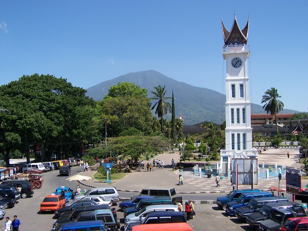


Bukittinggi, Indonesia
Bukittinggi is a town of 121,028 people in West Sumatra, Indonesia, founded in December 22, 1784.
Why visit Bukittinggi
Townapedia lists 14 museums and landmarks, 11 parks and trails, 78 places to eat, 58 places to stay and 8 attractions in and around town.
Highlights include Limpapeh Bridge, Museum Rumah Kelahiran Bung Hatta and Jam Gadang.
Weather in Bukittinggi
Forecast from MET Norway (CC BY 4.0). Full forecast
About Bukittinggi
Bukittinggi (Minangkabau: Bukiktinggi, Jawi: بوكيت تيڠڬي, formerly Dutch: Fort de Kock) is the third largest city in West Sumatra, Indonesia, with a population of 111,312 in 2010 and 121,028 in 2020. The official estimate as of mid 2025 lists a population of 125,920 (consisting of 62,809 males and 63,111 females). The city covers an area of 24.84 km2. It is located in the Minangkabau Highlands, 90 km by road from the West Sumatran capital city of Padang.
From the Wikipedia article Bukittinggi (this version), under CC BY-SA 4.0.
Travel tips from other travellers: Bukittinggi on Wikivoyage (CC BY-SA 4.0).
Things to do8


Museums and landmarks14

Museum Rumah Kelahiran Bung Hatta
Museum · 1.0 km
37 Jl. Soekarno Hatta, Bukittinggi
Mo-Sa 09:00-15:00; Su "Reservasi terlebih dahulu"; PH "Reservasi...

Jam Gadang
Monument and historic site
Colonial clocktower and major landmark of the city of Bukittinggi, West Sumatra, Indonesia




Koto Gadang Traditional Hall
Monument and historic site · 1.8 km
Balai Adat ini didirikan oleh anak negeri Koto Gadang untuk memperingati jasa J. Datoek Kajo, Larashoofd van X Koto dan ex...


2 more on the map.
Parks, trails and playgrounds11



Restaurants and cafes78

Nasi Kapau UNi Lis
Restaurant · Indonesian · 0.6 km
Jalan Pemuda
Mo-Su 09:00-18:00
Martabak Kaka Since 1923
Restaurant · 0.8 km
75 Jalan Ahmad Yani
Mo-Su 14:30-22:30

66 more on the map.
History
The city has its origins in five villages that served as the basis for a marketplace. It was known as Fort de Kock in colonial times in reference to the Dutch outpost established here in 1825 during the Padri War.
The fort was founded by Captain Bauer at the top of Jirek hill and later named after the then Lieutenant Governor-General of the Dutch East Indies, Hendrik Merkus de Kock. The first road connecting the region with the west coast was built between 1833 and 1841 via the Anai Gorge, easing troop movements, cutting the costs of transportation and providing an economic stimulus for the agricultural economy.
In 1856 a teacher-training college (Kweekschool) was founded in the city, the first in Sumatra, as part of a policy to provide education opportunities to the indigenous population. A rail line connecting the city with Payakumbuh and Padang was constructed between 1891 and 1894.
During the Japanese occupation of West Sumatra in World War II, the city was the headquarters for the Japanese 25th Army, the force that occupied Sumatra. The headquarters was moved to the city in April 1943 from Singapore and remained until the Japanese surrender in August 1945.
From the History section of Bukittinggi on Wikipedia, under CC BY-SA 4.0.
Where to stay58
The Hills Bukittinggi Hotel & Convention
Motel and hotel
Jalan Laras Dt Bandaro, Bukittinggi
Churches and places of worship34
Masjid Al-Falah Jambu Air
Place of worship · 1.9 km
Jalan Padang Panjang - Bukittinggi
Masjid Jami' Tigo Baleh
Place of worship · Sunni · 2.6 km
Jalan Parik Antang, Bukittinggi
Masjid Jamiak Gunjo
Place of worship · 2.2 km
Jl Nj. Dt. Mangkuto Ameh, Bukittinggi
Shopping14
Gas and EV charging7
Schools, colleges and libraries24
SMA Negeri 5 Bukittinggi
School · 2.7 km
Jl. Nj. Dt. Mangkuto Ameh, Koto Selayan, Bukittinggi
Healthcare19
Map of Bukittinggi
250 places. The map loads OpenStreetMap tiles when you open it.
Getting there and nearby towns
Minangkabau International Airport (PDG) is the nearest airport with scheduled flights listed in OpenStreetMap, 54 km away.
- Padangpanjang 17 km south, about 17 min by car
- Payakumbuh 31 km east, about 31 min by car
- Pariaman 44 km southwest, about 44 min by car
- Solok 63 km southeast, about 1 h by car
- Padang 71 km south, about 1 h 15 min by car
- Sijunjung 80 km southeast, about 1 h 15 min by car
Drive times are estimates from straight-line distance, not routes.
Local news
Headlines from INDB.
Reviews, tips and questions
Loading what members have shared...
Sources and licences
- GeoNames (CC BY 4.0): population, coordinates, regions and time zone
- OpenStreetMap contributors (ODbL 1.0): places, airports, map data
- Wikidata (CC0 1.0): elevation, founding date, time zone, website, landmarks and historic places
- Wikimedia Commons (see each image): photos
- Wikipedia (CC BY-SA 4.0): overview and history text
Photo credits
- Daily Bukittinggi, No machine-readable author provided. Hanafiannoy assumed (based on copyright claims)., Public domain
- KeBukittingi 6254, sbamueller, CC BY-SA 2.0
- Jam Gadang in 2011, Iwansw, CC BY-SA 3.0
- Memorial Fort de Kock, Tdevries, CC BY-SA 3.0
- Tri Daya Eka Dharma Museum, sbamueller, CC BY-SA 2.0
- SMA N 1 UNGGUL BUKITTINGGI TAMPAK DEPAN, Dwi Chania, CC BY-SA 4.0
- Mohammad Hatta Birth Place and Museum, Bukittinggi, West Sumatra 2017-02-13 01, Crisco 1492, CC BY-SA 4.0
- Masjid Raya Bukittinggi Okt 2020, Rhmtdns, CC BY-SA 4.0
- Bukittinggi 20190810, Rhmtdns, CC BY-SA 4.0
- Monumen Polisi Wanita, Official Website of The Ministry of Education and Culture, Public domain


Page built November 3, 2026. Spotted a mistake? Tell us or suggest a place.