




Why visit Ilion
Townapedia lists 14 museums and landmarks, 4 parks and trails, 4 places to eat and 1 attraction in and around town.
Highlights include Balloon Farm and Frankfort Town Hall.
July is the warmest month, with average highs of 81°F; January lows average 11°F.
Weather in Ilion
Forecast from the National Weather Service. Full forecast
About Ilion
Ilion is a village in Herkimer County, New York, United States. Located in the Mohawk Valley region, the population was 7,646 at the 2020 census.
From the Wikipedia article Ilion, New York (this version), under CC BY-SA 4.0.
Things to do1

Museums and landmarks14

Balloon Farm
Monument and historic site · National Register of Historic Places · 2.8 mi
Historic home located at Frankfort in Herkimer County, New York

Frankfort Town Hall
Monument and historic site · National Register of Historic Places · 2.5 mi
Rathaus in New York, United States of America

Herkimer County Courthouse
Monument and historic site · National Register of Historic Places · 2.8 mi
County courthouse in New York, United States of America

Herkimer County Historical Society
Monument and historic site · National Register of Historic Places · 2.8 mi
Historic house in New York, United States

Herkimer County Jail
Monument and historic site · National Register of Historic Places · 2.8 mi
Prison in New York, United States of America

Palatine German Frame House
Monument and historic site · National Register of Historic Places · 1.2 mi
Historic house in New York, United States

Remington House
Monument and historic site · National Register of Historic Places · 2.8 mi
Listed on the NRHP in New York
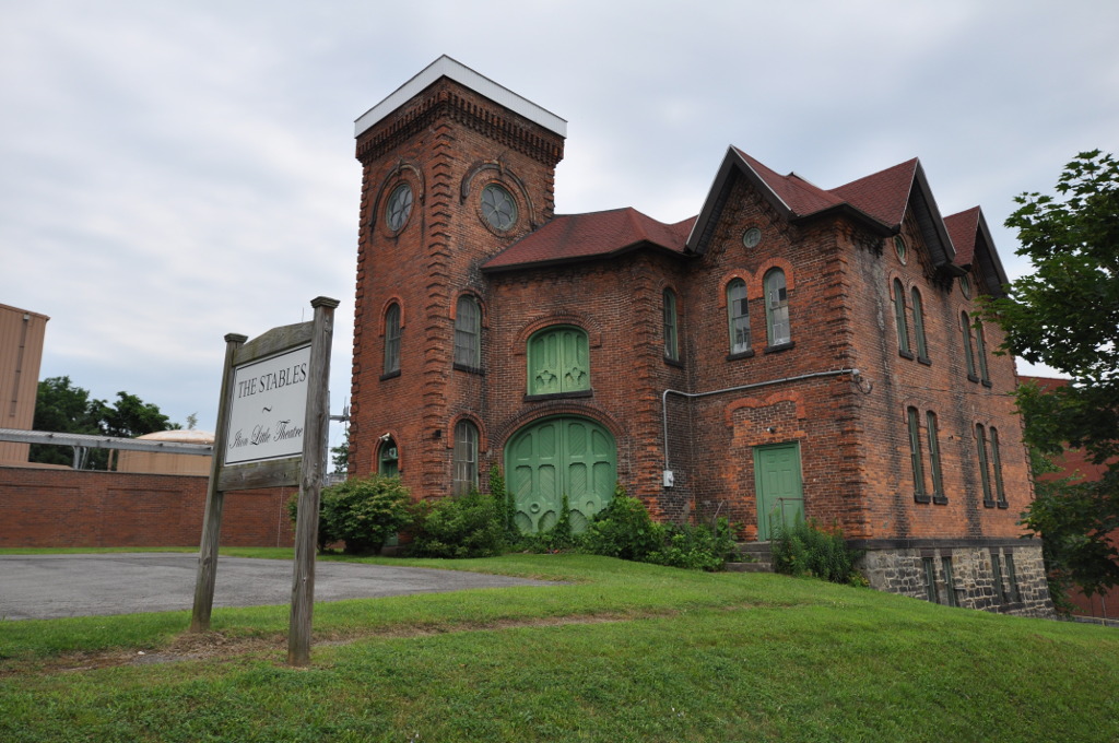
Remington Stables
Monument and historic site · National Register of Historic Places
Historic stable building located at Ilion, New York, United States
Thomas Richardson House
Monument and historic site · National Register of Historic Places · 0.7 mi
Historic house in New York, United States

United States Post Office
Monument and historic site · National Register of Historic Places · 2.4 mi
Government building in Frankfort, New York
United States Post Office
Monument and historic site · National Register of Historic Places
Government building in Ilion, New York


United States Post Office
Monument and historic site · National Register of Historic Places · 2.8 mi
Government building in Herkimer, New York
2 more on the map.
Parks, trails and playgrounds4

Restaurants and cafes4


History
The area where Ilion is located was first settled by Palatine Germans under the Burnetsfield Patent around 1725. Settlers first took plots along Steele Creek, which flows into the Mohawk River. Gradually they built many mills along the creek. After the American Revolution, a small community was set up in the area named "New London". This area of the village still has buildings which use the name "London".
The community began to flourish starting around 1816 when Eliphalet Remington created his first rifle. He developed the Remington Arms manufacturing company. The community was stimulated in growth by the completion in 1825 of the Erie Canal, which completed area trade and connection with products from the Great Lakes region.
In 1843 a post office was desired, so the people had to choose a name. Remington refused to be the namesake of the village, and it was eventually named Ilion.
The village of Ilion was incorporated in 1852. Ilion is one of only twelve villages in New York still incorporated under a charter, the others having incorporated or re-incorporated under the provisions of Village Law.
In December 2023 RemArms LLC announced that the Remington Arms factory located in the village will be permanently closed in March 2024, eliminating 300 jobs. The property was sold to a developer in December 2024. On March 4, 2025, the Remington Arms factory ceased operations for good.
From the History section of Ilion, New York on Wikipedia, under CC BY-SA 4.0.
Churches and places of worship9
First United Methodist Church
Church · National Register of Historic Places
The Reformed Church
Church · National Register of Historic Places · 2.8 mi
Shopping1
Gas and EV charging3
Schools, colleges and libraries17
Healthcare2
Map of Ilion
55 places. The map loads OpenStreetMap tiles when you open it.
Climate by month
Monthly table
| Month | High | Low | Rain |
|---|---|---|---|
| Jan | 30°F | 11°F | 3.1 in |
| Feb | 32°F | 12°F | 3.1 in |
| Mar | 40°F | 20°F | 3.4 in |
| Apr | 54°F | 32°F | 3.7 in |
| May | 68°F | 44°F | 4.0 in |
| Jun | 76°F | 54°F | 4.8 in |
| Jul | 81°F | 58°F | 5.1 in |
| Aug | 79°F | 56°F | 4.5 in |
| Sep | 73°F | 48°F | 4.0 in |
| Oct | 59°F | 38°F | 4.8 in |
| Nov | 47°F | 28°F | 3.8 in |
| Dec | 35°F | 18°F | 3.6 in |
U.S. Climate Normals 1991-2020 for Little Falls City Rsch Hcn (9 mi away), rain and snow from New Hartford 0.8 S, NOAA NCEI.
People and cost of living
American Community Survey 5-year estimates, 2020-2024, U.S. Census Bureau. Estimates have margins of error, larger for small towns.
Disaster history
Herkimer County has had 20 federal disaster declarations since 2000, most often for severe storms.
- 2020-03-20: Covid-19 Pandemic (Biological)
- 2020-03-13: Covid-19 (Biological)
- 2019-12-19: Severe Storms, Straight-Line Winds, And Flooding (Severe Storm)
- 2017-07-12: Severe Winter Storm And Snowstorm (Snowstorm)
- 2014-07-08: Severe Storms And Flooding (Severe Storm)
- 2013-07-12: Severe Storms And Flooding (Flood)
OpenFEMA disaster declarations summaries.
Getting there and nearby towns
Dolgeville Airport (1F6) is the nearest airport with scheduled flights listed in OpenStreetMap, 17 miles away.
- Frankfort 2 mi northwest, about 4 min by car
- Herkimer 3 mi northeast, about 4 min by car
- Utica 11 mi northwest, about 18 min by car
- Richfield Springs 11 mi south, about 18 min by car
- New Hartford 13 mi west, about 21 min by car
- Dolgeville 15 mi northeast, about 24 min by car
- Clinton 17 mi west, about 28 min by car
- Clark Mills 18 mi west, about 29 min by car
- Oriskany 18 mi northwest, about 29 min by car
- St. Johnsville 18 mi east, about 30 min by car
Drive times are estimates from straight-line distance, not routes.
Local news
Headlines from INDB, the NEMICO news database.
Reviews, tips and questions
Loading what members have shared...
Sources and licences
- NCES EDGE (Public domain): public schools
- NOAA NCEI U.S. Climate Normals 1991-2020 (Public domain): climate by month
- OpenFEMA (Public domain): disaster declarations
- OpenStreetMap contributors (ODbL 1.0): places, airports, map data
- U.S. Census Bureau (Public domain): population, income, housing, education, commute
- Wikidata (CC0 1.0): elevation, founding date, time zone, website, landmarks and historic places
- Wikimedia Commons (see each image): photos
- Wikipedia (CC BY-SA 4.0): overview and history text
Photo credits
- IlionNY PostOffice, Magicpiano, CC BY-SA 4.0
- IlionNY FirstMethodistChurch, Magicpiano, CC BY-SA 4.0
- IlionNY RemingtonStables, Magicpiano, CC BY-SA 4.0
- IlionPlaque, Mbdfar, CC BY 4.0
- USGS Steele Creek gauge Ilion, United States Geological Survey, Public domain
- IlionNY ThomasRichardsonHouse, Magicpiano, CC BY-SA 4.0
- U.S. Post Office Frankfort NY, Allan Green, CC BY-SA 4.0
- HerkimerNY PostOffice, Magicpiano, CC BY-SA 4.0
- Frankfort, New York Town Hall, Doug Kerr, CC BY-SA 2.0
- Remington House, Kinne Corners, NY, US, Jud McCranie, CC BY-SA 4.0
- Herkimer County Jail Sep 09, Doug Kerr from Upstate New York, CC BY-SA 2.0
- Herkimer County Courthouse Sept 09, Doug Kerr from Upstate New York, CC BY-SA 2.0
- Herkimer County Historical Society Sep 09, Doug Kerr from Upstate New York, CC BY-SA 2.0
- Balloon Farm Sep 2009, Doug Kerr from Upstate New York, CC BY-SA 2.0
- HerkimerNY PalatineGermanFrameHouse, Magicpiano, CC BY-SA 4.0
- Mohawk Valley flood relief 130704-Z-ZZ999-008, U.S. Army photo by Lt. Col. Christopher Panzer, New York National Guard Joint Force Headquarters/RELEASED, Public domain
- Mohawk Valley flood relief 130704-Z-ZZ999-009, U.S. Army photo by Lt. Col. Christopher Panzer, New York National Guard Joint Force Headquarters/RELEASED, Public domain
- New York National Guard responds to Mohawk Valley floods 130705-Z-ZZ999-012, U.S. Army National Guard photo by Lt. Col. Christopher Panzer/Released, Public domain
- Mohawk Valley Flood Relief 130705-Z-ZZ999-016, U.S. Army National Guard photo by Lt. Col. Christopher Panzer/Released, Public domain
- Mohawk Valley Flood Relief 130705-Z-ZZ999-015, U.S. Army National Guard photo by Lt. Col. Christopher Panzer/Released, Public domain
- Mohawk Valley flood relief 130705-Z-ZZ999-013, U.S. Army National Guard photo by Lt. Col. Christopher Panzer/Released, Public domain
- Mohawk Valley flood relief 130705-Z-ZZ999-014, U.S. Army National Guard photo by Lt. Col. Christopher Panzer/Released, Public domain
- Mohawk Valley flood relief 130705-Z-ZZ999-017, U.S. Army National Guard photo by Lt. Col. Christopher Panzer/Released, Public domain
- Mohawk Valley flood relief 130704-Z-ZZ999-102, U.S. Army photo by Maj. Sean Flynn, New York National Guard Joint Force Headquarters, Public domain
- Mohawk Valley flood relief 130704-Z-ZZ999-101, U.S. Army photo by Lt. Col. Christopher Panzer, New York National Guard Joint Force Headquarters/RELEASED, Public domain
- Mohawk Valley flood relief 130705-Z-ZZ999-003, U.S. Army National Guard photo by Lt. Col. Christopher Panzer/Released, Public domain
- Mohawk Valley Flood Relief 130705-Z-ZZ999-018, U.S. Army National Guard photo by Lt. Col. Christopher Panzer/Released, Public domain
- Mohawk Valley flood relief 130704-Z-ZZ999-004, U.S. Army photo by Lt. Col. Christopher Panzer, New York National Guard Joint Force Headquarters, Public domain


Page built October 30, 2026. Spotted a mistake? Tell us or suggest a place.