


Bhālswa Jahangirpur, India
Bhālswa Jahangirpur is a town of 197,148 people in Delhi, India.
Why visit Bhālswa Jahangirpur
Townapedia lists 8 museums and landmarks, 20 parks and trails, 33 places to eat, 6 places to stay and 2 attractions in and around town.
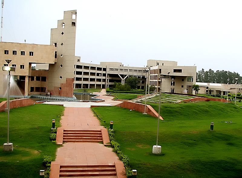
Highlights include Delhi Technological University, Coronation Park and Municipal Park.
Weather in Bhālswa Jahangirpur
Forecast from MET Norway (CC BY 4.0). Full forecast
Things to do2
Delhi Technological University
School · 5.1 km
State public university in North West, Delhi, India

Museums and landmarks8


Parks, trails and playgrounds20




Yamuna biodiversity park
Park · 4.7 km
9770-hectare biodiversity area in Delhi

8 more on the map.
Restaurants and cafes33

Food Six
Restaurant · Chinese, Pizza, Coffee Shop, Tea, Ice Cream, Burger, Indian, Sandwich, Cake · 0.7 km
K Block Jahangirpuri road, Delhi
Mo-Su 09:00-21:00



21 more on the map.
Where to stay6
Churches and places of worship56
Jai Baliya Baba Sheshnag Mandir
Place of worship · 1.8 km
335/1 Gali Number 8, Delhi
Shopping7
Organic Harvest, wazir pur
Grocery · 1.9 km
Bus Depot, A Block, 1st Floor, HAFED Complex, adjoining Wazir Pur, New Delhi, Delhi 110035, delhi
Gas and EV charging5
Schools, colleges and libraries28
Healthcare72
Map of Bhālswa Jahangirpur
237 places. The map loads OpenStreetMap tiles when you open it.
Getting there and nearby towns
Hindon Airport (HDO) is the nearest airport with scheduled flights listed in OpenStreetMap, 19 km away.
- Mukandpur 2 km east, about 2 min by car
- Libāspur 3 km northwest, about 3 min by car
- Kamal Pur Majra Burari 3 km northeast, about 3 min by car
- Delhi 11 km southeast, about 11 min by car
- New Delhi 14 km south, about 14 min by car
- Delhi Cantonment 15 km south, about 15 min by car
- Najafgarh 23 km southwest, about 23 min by car
- Ghāziābād 28 km east, about 28 min by car
- Faridabad 39 km south, about 39 min by car
- Meerut 59 km northeast, about 59 min by car
Drive times are estimates from straight-line distance, not routes.
Local news
Headlines from INDB.
Reviews, tips and questions
Loading what members have shared...
Sources and licences
- GeoNames (CC BY 4.0): population, coordinates, regions and time zone
- OpenStreetMap contributors (ODbL 1.0): places, airports, map data
- Wikidata (CC0 1.0): elevation, founding date, time zone, website, landmarks and historic places
- Wikimedia Commons (see each image): photos
Photo credits
- DelhiCollegeOfEngineering BawanaCampus, Hemant Badhani Original uploader was Gnusbiz at en.wikipedia, CC BY 2.0
- Coronation Park, Delhi 51, Harshanh, CC BY-SA 4.0
- Shalimar Gardens, Delhi, 1814-15, Sita Ram, Public domain
- Bhalaswa metro station, AutobotIndian, CC BY 4.0
- Maqbara Paik (7987886607), Varun Shiv Kapur from New Delhi, India, CC BY 2.0
- Maqbara Paik (7987891622), Varun Shiv Kapur from New Delhi, India, CC BY 2.0
- Eicher Truck at Azadpur Vegetable Market, Prateek Rungta from Delhi, India, CC BY 2.0
- Thela Gaadi (5823921855), Prateek Rungta from Delhi, India, CC BY 2.0
- Quila Park, Near Bharola, Azadpur 03, Harshanh, CC BY-SA 4.0
- Quila Park, Near Bharola, Azadpur 01, Harshanh, CC BY-SA 4.0
- Quila Park, Near Bharola, Azadpur 02, Harshanh, CC BY-SA 4.0
- Quila Park, Near Bharola, Azadpur 10, Harshanh, CC BY-SA 4.0
- Quila Park, Near Bharola, Azadpur 04, Harshanh, CC BY-SA 4.0
- Badli Sarai (7987889382), Varun Shiv Kapur from New Delhi, India, CC BY 2.0
- Badli Sarai (7987884417), Varun Shiv Kapur from New Delhi, India, CC BY 2.0
- Haiderpur Badli Mor Interchange Station, Kishy-edits, CC BY-SA 3.0
- Quila Park, Near Bharola, Azadpur 06, Harshanh, CC BY-SA 4.0
- Quila Park, Near Bharola, Azadpur 05, Harshanh, CC BY-SA 4.0
- Quila Park, Near Bharola, Azadpur 09, Harshanh, CC BY-SA 4.0
- Quila Park, Near Bharola, Azadpur 08, Harshanh, CC BY-SA 4.0
- Quila Park, Near Bharola, Azadpur 07, Harshanh, CC BY-SA 4.0
- Sheesh Mahal, Shalimar Bagh, Delhi 19, Harshanh, CC BY-SA 4.0
- Sheesh Mahal, Shalimar Bagh, Delhi- 12, Harshanh, CC BY-SA 4.0
- Sheesh Mahal, Shalimar Bagh, Delhi- 10, Harshanh, CC BY-SA 4.0
- Sheesh Mahal, Shalimar Bagh, Delhi- 11, Harshanh, CC BY-SA 4.0
- Sheesh Mahal, Shalimar Bagh, Delhi- 02, Harshanh, CC BY-SA 4.0
- Sheesh Mahal, Shalimar Bagh, Delhi- 01, Harshanh, CC BY-SA 4.0
- Sheesh Mahal, Shalimar Bagh, Delhi- 03, Harshanh, CC BY-SA 4.0
- Sheesh Mahal, Shalimar Bagh, Delhi- 04, Harshanh, CC BY-SA 4.0
- Sandstone closeup - Sheesh Mahal, Shalimar Bagh, Delhi 05, Harshanh, CC BY-SA 4.0
- Sheesh Mahal, Shalimar Bagh, Delhi 18, Harshanh, CC BY-SA 4.0
- Sheesh Mahal, Shalimar Bagh, Delhi- 13, Harshanh, CC BY-SA 4.0
- Sheesh Mahal, Shalimar Bagh, Delhi- 14, Harshanh, CC BY-SA 4.0
- Sheesh Mahal, Shalimar Bagh, Delhi- 15, Harshanh, CC BY-SA 4.0
- Sheesh Mahal, Shalimar Bagh, Delhi 16, Harshanh, CC BY-SA 4.0
- Sheesh Mahal, Shalimar Bagh, Delhi 17, Harshanh, CC BY-SA 4.0
- Sheesh Mahal, Shalimar Bagh, Delhi- 08, Harshanh, CC BY-SA 4.0
- Sheesh Mahal, Shalimar Bagh, Delhi- 06, Harshanh, CC BY-SA 4.0
- Sheesh Mahal, Shalimar Bagh, Delhi- 07, Harshanh, CC BY-SA 4.0
- Sheesh Mahal, Shalimar Bagh, Delhi- 09, Harshanh, CC BY-SA 4.0
- Sheesh Mahal, Shalimar Bagh, Delhi 32, Harshanh, CC BY-SA 4.0


Page built November 2, 2026. Spotted a mistake? Tell us or suggest a place.